Atlas of the antiquity
Jump to navigation
Jump to search

|
Wikimedia Commons Atlas of the World The Wikimedia Atlas of the World is an organized and commented collection of geographical, political and historical maps available at Wikimedia Commons. Discussion • Update the atlas • Index of the Atlas • Atlas in categories • Other atlases on line |
The introductions of the country, dependency and region entries are in the native languages and in English. The other introductions are in English.
|
Antiquity |
Atlas of the antiquity
The Atlas of the antiquity has to be filled with maps. More information: Update the atlas.
|
Ancient Egypt
[edit]
|
Ancient Egypt, from the delta to the fifth cataract, shows selection of the most important cities |
Ancient Greece
[edit].svg)
|
Pelasgian Presence mentioned by ancient writers |
.svg)
|
The life of Orpheus |

|
The life of Orpheus (svg, translatable) |
.svg)
|
Expulsion of the Pieres from the region of Olympus to the region of Pangaion by the Macedonians |
.svg)
|
Karanus of Macedon |

|
The Beginnings of Historic Greece. 700 - 600 B.C. |
| [[|border|251x400px]] | Hellenic Battles,700-168 BC |
.svg)
|
Hellenic Battles,700-168 BC [svg] |
.jpg)
|
The archaic period in Greece (750 BC – 480 BC) |

|
old Map of Ancient Greece |

|
old Map of Ancient Greece |

|
Graecia Vetus |

|
Ancient Greece, Northern part |

|
Ancient Greece, southern regions |
.svg)
|
Ancient Greece, northern regions |

|
Ancient Greek colonies on the northern coast of the Black Sea |

|
Persian Wars of the 5th Cent BCE |

|
Persian invasion of Greece (480 BC-479 BC) |
.png)
|
Dionysius of Syracuse's military attempts to place Alcetas in the throne of the Molossians, 385 BC |

|
Greek cities in the Adriatic coast |

|
371 BC - 362 BC, Theban Hegemony |
.svg)
|
Expansion of Macedon, 431 BC, 336 BC |

|
Ancient Epirus |
.svg)
|
Epirus & Environs (svg) |

|
Epirus & Environs |
_(English).jpg)
|
Pyrrhic Wars, (280–275 BC) |

|
Antigonus II Gonatas, northern border at 250 bc |

|
Antigonus II Gonatas, northern border at 240 bc |

|
Mediterranean at 218 BC |

|
2nd Macedonian War, 200 BC |
Ancient Rome
[edit]
|
Expansion of Rome, 2nd century BC |

|
Route of Hannibal's invasion |

|
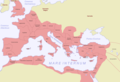
Extent of the Roman Empire in 218 BC (dark red), 133 BC (light red), 44 BC (orange), AD 14 (yellow), later acquisitions (green) and Trajan's Eastern conquests (light green) |

|
Roman provinces in the central Balkans |

|
Roman Provinces |

|
Roman era Balkans |

|
Roman Empire boundaries between 60-400 AD |

|
boundaries of the western and eastern Roman empires after the death of Theodosius I, in 395 AD |

|
Praetorian Prefectures of the Roman Empire (395 AD) |

|
"barbarian" invasions of the Roman Empire showing the major incursions from 100 to 500 CE |
Dacia
[edit]
|
Roman era Balkans |

|
Dacia 82 B.C. |

|
Dacia in Ist century A.D. |
.svg)
|
The Roman province of Dacia |
Thrace
[edit]
|
Thracian language extent according to Duridanov |
.png)
|
Ancient Thrace |

|
ancient Thrace,map made in 1585 |
.svg)
|
Odrysian kingdom 431 BC |
.svg)
|
Paeonia & Environs |
.svg)
|
Paeonia & Environs |

|
Paeonia |

|
Paionia |

|
Tribes in Thrace & Celtic migrations |
.svg)
|
Celtic migrations |
.svg)
|
Tribes in Thrace |

|
Tribes in Thrace |
.jpg)
|
Triballi |
Illyria
[edit].svg)
|
Illyrian Etnogenesis |
.png)
|
Prehistoric Illyrians;Sites and Cultures |
.jpg)
|
Prehistoric Illyrians;Sites and Cultures |
.svg)
|
Illyrian tribes |
.svg)
|
Illyrians, Illyria Barbara, Illyria Graeca, Illyrians Proper and Environs |
.png)
|
Approximate extent of the Illyrian territories prior to Roman conquest |
.svg)
|
Illyrian tribes (svg) |

|
Illyrian tribes |

|
(svg) Illyrians Proper |
.svg)
|
Dardania & Environs |
.png)
|
Kingdom of Agron of the Ardiaei (250 BC - 230 BC) |

|
Kingdom of Teuta 230 - 228 BC |
.png)
|
Roman Client state governed by Demetrius of Pharos (228 - 220 BC) |
| [[|border|251x400px]] | Kingdom of Gentius (181 BC - 167 BC) |
.svg)
|
Great Illyrian Revolt |
-
 Geography of the Ancient Rome: Roman Empire, 116AD ; provinces, mediterranean shores (Mare Nostrum).
 -
 Chernyakhov culture, 4th century, in orange color. Genuine Goth people mix with Getes(Scythic tribes), as known previously by the Greeks.
 -
 Locator of Dacia ; from 2nd century to 376 it is the first settlement kingdom for the Goths at the borderline of the Empire.
 -
 'Gothic' migrations according to Madison Grant (1916)


Notes and references
[edit]|
General remarks:
|