| |
|

|
Sicily
|
|
|
|
|
|
|
|
Sicilia
|
|
|
|
| Italiano
|
Sicilia - Regione Sicilia
La Sicilia è una regione autonoma a statuto speciale, facente parte dell'Italia insulare. Coi suoi 25.710 km² è la regione più estesa d'Italia, nonché la più grande isola del Mar Mediterraneo. È abitata da circa 5.1 milioni di persone, ed ha come capoluogo Palermo. È una delle mete turistiche più importanti d'Italia e nel Settecento era l'ultima tappa del Grand Tour, il viaggio che i giovani aristocratici inglesi compivano in Europa per istruirsi.
|
| Sicilianu
|
Sicilia - Riggiuni Sicilia
La Sicilia è n'ìsula taliana ntô Mari Miditirràniu. Si stenni pi 25,708 km² di supirfici e havi 5.098.034 abbitanti (1998). È la cchiù granni riggiuni d'Italia e rapprisenta un dudicèsimu di lu tirritoriu talianu.
Cci nni càmpanu circa 5,1 milioni di persuni. Lu nùmmuru d'abbitanti è lu terzu cchiù àutu di tutti li riggiuna di l'Italia. Havi na dinzitati di pupulazzioni di 198 abbitanti p'ogni km².
Palermu è la capitali cu na pupulazzioni di quasi 700.000 abbitanti. La Sicilia si cumponi di 9 pruvincî e havi un tutali di 390 cumuna di li quali 199, lu 51%, hannu menu di 5.000 abbitanti. La pupulazzioni risidenti nta sti cumuna cu menu di 5.000 abbitanti rapprisenta lu 10% di tutta la pupulazzioni dâ riggiuni.
|
| English
|
Sicily - Region of Sicily
Sicily (Sicilia in Italian and Sicilian) is an autonomous region of Italy and the largest island in the Mediterranean Sea, with an area of 25,708 km² (9,926 sq. miles) and five million inhabitants. It lies north of ► Tunisia and ► Malta.
|
| Other languages
|
Deutsch: Sizilien ist die größte Insel im Mittelmeer. Sie liegt südwestlich vor der „Stiefelspitze“ der Apennin-Halbinsel, und ihr Westende ist nur 160 km von der Küste Tunesiens entfernt. Politisch bildet Sizilien gemeinsam mit einigen kleineren Inseln eine autonome Region der Republik Italien und ist in neun Provinzen mit insgesamt 390 Gemeinden aufgeteilt. Hauptstadt ist Palermo. Weitere Informationen unter de:Portal:Sizilien.
Français: La Sicile est une région autonome d'Italie et la plus grande île de la Méditerranée. Outre l'italien qui est la langue officielle, la plupart des habitants parlent aussi le sicilien, langue d'origine latine avec des influences arabe, germanique, espagnole, française et italienne. À l'intérieur même du dialecte Sicilien, on trouve d'autres dialectes, différents suivant les endroits de la Sicile. Sa capitale est la ville de Palerme.
|
|
| Short name
|
Sicily
|
| Official name
|
Region of Sicily
|
| Status
|
Autonomous region of ► Italy
|
| Capital
|
Palermo
Palermu
|
| Population
|
4,999,891 inhabitants
|
| Area
|
25,708 km²
|
| Major languages
|
Italian, Sicilian
|
| Major religions
|
Roman Catholicism
|
| More information
|
Sicily, Geography of Sicily, History of Sicily and Politics of Sicily
|
| More images
|
Sicily - Sicily (Category).
|
|


 General map
 Cities
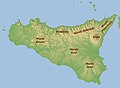 Mountains
 Rivers


