The Independent State of Papua New Guinea is a country in Oceania, occupying the eastern half of the island of New Guinea and numerous offshore islands (the western portion of the island is occupied by the ► Indonesian provinces of Papua and West Irian Jaya). It is located in the southwestern Pacific Ocean, in a region defined since the early 19th century as Melanesia., and has maritime borders with ► Micronesia, ► Nauru, the ► Solomon Islands and ► Australia. In the east lies the autonomous province of ► Bougainville. Its capital, and one of its few major cities, is Port Moresby. It is one of the most diverse countries on Earth, with over 850 indigenous languages and at least as many traditional societies, out of a population of just under 6 million. It is also one of the most rural, with only 18 per cent of its people living in urban centres. The country is also one of the world's least explored, culturally and geographically, and many undiscovered species of plants and animals are thought to exist in the interior of Papua New Guinea.
Map of Papua New Guinea, with location of most important cities.
Location map of the 22 provinces of Papua New Guinea, including the capital district and the autonomous region of Bougainville (since 2012).
Location map of the 20 provinces of Papua New Guinea, including the capital district and the autonomous region of Bougainville (before 2012).
Administrative map of Papua New Guinea (2004), with names of archipelagos, and the former subdivision into 20 provinces, including the capital district and the former province (now an autonomous region) of Bougainville (Northern Solomons).
Topographic and administrative map of Papua New Guinea (1985), with names of archipelagos, and the former subdivision into 20 provinces, including the capital district and the former province (now an autonomous region) of Bougainville (Northern Solomons).
Topographic and administrative map of Papua New Guinea (1989), with names of archipelagos, and the former subdivision into 20 provinces, including the capital district and the former province (now an autonomous region) of Bougainville (Northern Solomons).
Southern Highlands Province (before 2012), including the newer Hela Province (since 2012)
Western Highlands Province (before 2012), including the newer Jiwaka Province (since 2012)
Momase Region
Momase Region
Morobe Province
Madang Province
East Sepik Province
West Sepik (or Sandaun) Province
Islands Region
Islands Region
Manus Province
New Ireland Province
East New Britain Province
West New Britain Province
Autonomous Region of Bougainville (Northern Solomons)
Other maps
Map of Bougainville (Northern Solomons)
Basic divisions of New Guinea island, including parts from en:Indonesia and Papua New Guinea (before 2012).
History maps
This section holds a short summary of the history of the area of present-day Papua New Guinea, illustrated with maps, including historical maps of former countries and empires that included present-day Papua New Guinea.
Division of the Germany colonies in Oceania after World War I
Old maps
This section holds copies of original general maps more than 70 years old.
Map of New Guinea ('Nova Guinea'), Spanish/Portuguese, c.1600; as reproduced in G. Collingridge's 1906 work, "The First Discovery of Australia and New Guinea"
Notes and references
General remarks:
The WIKIMEDIA COMMONS Atlas of the World is an organized and commented collection of geographical, political and historical maps available at Wikimedia Commons. The main page is therefore the portal to maps and cartography on Wikimedia. That page contains links to entries by country, continent and by topic as well as general notes and references.
Every entry has an introduction section in English. If other languages are native and/or official in an entity, introductions in other languages are added in separate sections. The text of the introduction(s) is based on the content of the Wikipedia encyclopedia. For sources of the introduction see therefore the Wikipedia entries linked to. The same goes for the texts in the history sections.
Historical maps are included in the continent, country and dependency entries.
The status of various entities is disputed. See the content for the entities concerned.
The maps of former countries that are more or less continued by a present-day country or had a territory included in only one or two countries are included in the atlas of the present-day country. For example the Ottoman Empire can be found in the Atlas of Turkey.


.svg)

_2012.png)
.png)


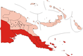 Papua Region
 National Capital District
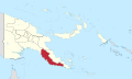 Central Province
 Gulf Province
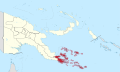 Milne Bay Province
 Northern (or Oro) Province
 Western (or Fly) Province
.svg)


.svg)


 Highlands Region
 Chimbu (or Simbu) Province
 Enga Province
 Eastern Highlands Province
 Southern Highlands Province (since 2012)
 Hela Province (since 2012)
 Western Highlands Province (since 2012)
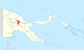 Jiwaka Province (since 2012)
 Southern Highlands Province (before 2012), including the newer Hela Province (since 2012)
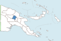 Western Highlands Province (before 2012), including the newer Jiwaka Province (since 2012)


 Momase Region
 Morobe Province
 Madang Province
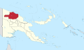 East Sepik Province
 West Sepik (or Sandaun) Province


 Islands Region
 Manus Province
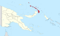 New Ireland Province
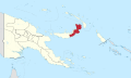 East New Britain Province
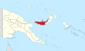 West New Britain Province
 Autonomous Region of Bougainville (Northern Solomons)
.svg)


.svg)


