ليمن دولة تقع جنوب شبه الجزيرة العربية في جنوب غرب آسيا. يحدها من الشمال السعودية ومن الشرق عُمان. لها ساحل جنوبي على بحر العرب و الجمهورية اليمنيةساحل غربي على البحر الأحمر. كانت حتى عام 1990 تتشكل من دولتين عرفتا باسمي الجمهورية العربية اليمنية في الشمال وجمهورية اليمن الديمقراطية الشعبية في الجنوب.
The Republic of Yemen is a Middle Eastern country located on the Arabian Peninsula in Southwest Asia. Yemen is composed of former North and South Yemen. It borders the Arabian Sea and Gulf of Aden on the south, the Red Sea on the west, ► Oman to the northeast and the rest of the country borders ► Saudi Arabia. It has maritime borders with ► Eritrea, ► Djibouti and ► Somalia, esp. ► Somaliland. Its territory includes the remote island of Socotra, about 350 kilometres (217 mi) to the south off the coast of East Africa.
This section holds a short summary of the history of the area of present-day Yemen, illustrated with maps, including historical maps of former countries and empires that included present-day Yemen.
Karib'il Watar's war against the kingdom of Awsan (about 685 or 450 BC)
This section holds copies of original general maps more than 70 years old.
Image:Aden gulf 1860.jpg
Other maps
Ethnic map
Notes and references
General remarks:
The WIKIMEDIA COMMONS Atlas of the World is an organized and commented collection of geographical, political and historical maps available at Wikimedia Commons. The main page is therefore the portal to maps and cartography on Wikimedia. That page contains links to entries by country, continent and by topic as well as general notes and references.
Every entry has an introduction section in English. If other languages are native and/or official in an entity, introductions in other languages are added in separate sections. The text of the introduction(s) is based on the content of the Wikipedia encyclopedia. For sources of the introduction see therefore the Wikipedia entries linked to. The same goes for the texts in the history sections.
Historical maps are included in the continent, country and dependency entries.
The status of various entities is disputed. See the content for the entities concerned.
The maps of former countries that are more or less continued by a present-day country or had a territory included in only one or two countries are included in the atlas of the present-day country. For example the Ottoman Empire can be found in the Atlas of Turkey.


 Abyan
Abyan Ad Dali
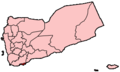 Adan
Adan al-Bayda
 al-Hudaydah
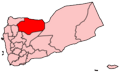 al-Jawf
 al-Mahrah
 al-Mahwit
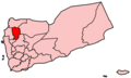 Amran
Amran Dhamar
 Hadhramaut
 Hajjiah
 Ibb
Ibb Lahij
Lahij Marib
Marib Sadah
Sadah Sanaa
Sanaa Shabhaw
 Taizz
Taizz


