Atlas of Nepal

From Wikimedia Commons, the free media repository
Jump to navigation Jump to search
Wikimedia Commons Atlas of the World

The Wikimedia Atlas of the World is an organized and commented collection of geographical, political and historical maps available at Wikimedia Commons.
Discussion • Update the atlas • Index of the Atlas • Atlas in categories • Other atlases on line
The introductions of the country, dependency and region entries are in the native languages and in English. The other introductions are in English.
 
Atlas-country
Nepal


नेपाल

नेपाली नेपाल - सङ्घीय लोकतान्त्रिक गणतन्त्र नेपाल[1]

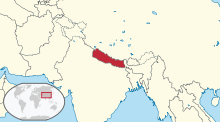
नेपाल दक्षिण एशियामा हिमालयको काखमा अवस्थित एक भूपरिबेस्ठित अधिराज्य हो। उत्तरमा तिब्बत (चीन) र बाँकी दिशामा भारत सित यसको सिमाना गांसिएको छ। नेपालमा कुल जनसङ्ख्याको ८०% भन्दा बढी हिन्दू धर्मका अनुयायीहरु छन्। अनुपातमा सानो भएपनि यो मुलुक समथल तराई देखि उच्च हिमाली भूभाग जस्ता भौगोलिक बिभिधताले भरिपूर्ण छ। सगरमाथा सहित विश्वका सबैभन्दा अग्ला १० मध्ये ८ शिखर नेपालमै छन्। राजधानि काठमाण्डौ लगायत, बिराटनगर, बिरगञ्ज, पोखरा, भैरहवा, नेपालगञ्ज आदि देशका प्रमुख सहरहरु हुन्।

English Nepal - Federal Democratic Republic of Nepal

The Federal Democratic Republic of Nepal, is a landlocked Himalayan country in South Asia, bordered by ► China (► Tibet) to the north and by ► India to the south, east and west. Nepal is a kingdom of various geographical features, and is culturally rich. More than 80% of Nepalese follow Hinduism, which is higher than the percentage of Hindus in India, making it the single most Hinduic nation in the world. For a small territory, the Nepali landscape is uncommonly diverse, ranging from the humid Terai in the south to the lofty Himalayas in the north. Nepal boasts eight of the world's ten highest mountains, including Mount Everest on the border with China. Kathmandu is the capital and largest city.


Short name  Nepal
Official name Federal Democratic Republic of Nepal
Status Independent country, united since 1768
Location South Asia
Capital काठमाण्डौ[2]
Population 29,996,478 inhabitants
Area 147,181 square kilometres (56,827 sq mi)
Major languages Nepali (official), Maithili, Bhojpuri, Tharu (Dagaura/Rana), Tamang
Major religions Hinduism, Buddhism, Islam
More information Nepal, Geography of Nepal, History of Nepal and Politics of Nepal
More images Nepal - Nepal (Category).

General maps

Map of Nepal
Map of Nepal
Topographic map
Geographic regions
Numbered zones of Nepal
Districts of Nepal
Development regions

History maps

This section holds a short summary of the history of the area of present-day Nepal, illustrated with maps, including historical maps of former countries and empires that included present-day Nepal.

Maurya and Gupta Empires
[[|border|251x400px]] Mauryan Empire (250 BCE)
Mauryan Empire
Mauryan Empire
Gupta Empire (400 AD)
Gupta Empire
Gupta Empire
Delhi Sultanate (13th century)
Sher Shah's Empire (around 1500)

Old maps

This section holds copies of original general maps more than 70 years old.

Hindustan in 1812 by Arrowsmith and Lewis

Ethno-linguistic maps

Languages of South Asia
Indo-arian languages

Other maps

Population density
Ethnic map

Satellite maps

Satellite map
Satellite map of Nepal and region


Notes and references

General remarks:

  • The WIKIMEDIA COMMONS Atlas of the World is an organized and commented collection of geographical, political and historical maps available at Wikimedia Commons. The main page is therefore the portal to maps and cartography on Wikimedia. That page contains links to entries by country, continent and by topic as well as general notes and references.
  • Every entry has an introduction section in English. If other languages are native and/or official in an entity, introductions in other languages are added in separate sections. The text of the introduction(s) is based on the content of the Wikipedia encyclopedia. For sources of the introduction see therefore the Wikipedia entries linked to. The same goes for the texts in the history sections.
  • Historical maps are included in the continent, country and dependency entries.
  • The status of various entities is disputed. See the content for the entities concerned.
  • The maps of former countries that are more or less continued by a present-day country or had a territory included in only one or two countries are included in the atlas of the present-day country. For example the Ottoman Empire can be found in the Atlas of Turkey.
  1. Romanization: Nepāl - Sanghiya Loktāntrik Ganatantra Nepāl.
  2. Romanization: Kathmandu.

Entries available in the atlas

General pages
World
Continents and oceans
Themes
Historical eras
States with wide recognition
States with limited recognition
Dependencies and other overseas territories
Country subdivisions
Belgium
China (mainland)
India
Pakistan
Spain
United Kingdom
United States
Other
Disputed subnational territories
Other regions
Cities
Former sovereign states
Former dependencies and overseas territories
Former disputed territories


References