Atlas of the Middle Ages
Jump to navigation
Jump to search

|
Wikimedia Commons Atlas of the World The Wikimedia Atlas of the World is an organized and commented collection of geographical, political and historical maps available at Wikimedia Commons. Discussion • Update the atlas • Index of the Atlas • Atlas in categories • Other atlases on line |
The introductions of the country, dependency and region entries are in the native languages and in English. The other introductions are in English.
|
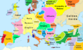
Middle Ages |
Atlas of the Middle Ages
Selected modern and old maps showing the history of the Early Middle Ages.
|

See' Hiberno-Saxon & Celtic art.
Context
[edit]Purpose
[edit]The main purpose for this page is to give a visual geographic reference regarding the rise, evolution and fall of countries in Europe from Antiquity to the Modern era. The birth of the modern European nation-state is a later phenomemon (generally evolved from the 17th century Peace of Westphalia, to the rise of modern European nationalism in the mid 1800's.)
Borders for most historical maps are largely arbitrary and in many cases are merely approximate.
Timelines
[edit]- Late Antiquity
- until 375
- Events: Maps will display basis situation for the Roman provinces ;
- Migration Period
- 376 - 476
- Events: Last 100 years before the last Emperor in the West ;
- in 376, Goths move & will win a victory over roman legions (378 : near Hadrianopolis).
- timeline is here quite reduced from the Timeline of the Migrations Period ;
- Early Middle Ages
- High Middle Ages
- 950 - 1250
- Events: in fr. hist.grphy., this might be a golden age in Western Europe, known as Moyen Âge central.
for instance Ordre de Cluny spreads its knowledge (Cluniac movement is portrayed as a follow-up of renaissance by Otto I).
This deals with the idea of a "Medieval civilization" that severed its ties with the former Roman times (refer to History of ideas), despite a Latin Europe still remains in cultural matters ;
- Late Middle Ages
- Renaissance Period starts
- from 1401
- Events: Quattrocento precedes High Renaissance in Art, which is Cinquecento.
- Nota bene :
- The Renaissance involves much historiography; see w:Early Modern Times
Maps before
[edit]-
 Generic Völkerwanderung map (2nd-5th century CE).
 -
 twice : range from 250 (Goths, Dacia) to 534 (Vandals, Africa)
 -
 French counterpart map of the previous, 100-500AD
 -
 Nodal growth of the Alemanic kingdom from 268 to 378 (explanations on the pic file)
 -
 Roman provinces, 395AD, at the death of Emperor Theodosius I
 -
 Roman provinces, 395AD, at the death of Emperor Theodosius I (more detailed and accurate version)
 -
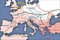
 Europe AD400 : Huns move from the East & will enter Germania. Goths splitted (Tervingen / Greuthungen) & feld through roman provinces.
 -
 400-410 : Roman Britain, see Old maps of the United Kingdom
 -
 Europe AD450 - all of a sudden, the Empire of the Huns has risen over Germania + ... .
 -
 Vandals had settled in Carthage and built up a fleet ; in 455, led by Geiseric they invade the sea and heavily sack Rome.
 -
 Maps of Roman Gaul still accurate to describe where foederati people settle : Franks in Belgica, Visigoths in Aquitanica, Burgundi in East Gallia.


Maps : Early Middle Ages
[edit]-
![Ostrogothic Kingdom during the reign of Theodoric. He took Italy from usurper Odoacer after a battle in 493. Formerly Ostrogoths were massed in diocesis Illyricum. [ locator ]](https://upload.wikimedia.org/wikipedia/commons/thumb/f/f9/Ostrogothic_Kingdom.png/120px-Ostrogothic_Kingdom.png) Ostrogothic Kingdom during the reign of Theodoric. He took Italy from usurper Odoacer after a battle in 493. Formerly Ostrogoths were massed in diocesis Illyricum.
Ostrogothic Kingdom during the reign of Theodoric. He took Italy from usurper Odoacer after a battle in 493. Formerly Ostrogoths were massed in diocesis Illyricum.
[ locator ] -
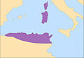
 Acme of Visigothic kingdom around 500. Franks are to take over former Gallia Aquitania during Battle of Vouillé, 507.
 -
 Britain divided by kinglets at the brink of 6th Century.
 -
 two maps (AD526 ; AD600) : Migrations period ended in Western Europe (yet, a follow-up concerns the Byzantine Empire in Eastern parts) .
 -
 Justinian reconquers parts AD527 to AD565; end of Vandals' kingdom & Ostrogothic kingdom. Andalucia retaken to the visigoths.
 -
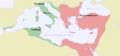 Same as previous map, year 550.
 -
![Roman Hispania conquered at the death of Justinian, 565AD. [Category:Maps of Roman Hispania]](https://upload.wikimedia.org/wikipedia/commons/thumb/4/4b/Hispania_565.png/120px-Hispania_565.png)
-
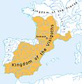
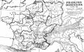 "Domains of the Franks", AD511 to 561, built-up out of the tiny Domain of Soissons (486).
 -
 Dark Age of Camelot around 600 recovers a time of legends as Anglo-Saxon heptarchy compete & Brython tribes offer resistance.
 -
 Natives & Anglo-Saxons settlements, 600. Compare with previous
 -
-
 802 : "Medieval" Britain started - same map in WP:FR, 800 .
 -
 Carolingian Empire 814AD rules in the West + Central Europe, at the death of Charlemagne.
 -
![Identified powers in this World, around 820AD. [ use ].](https://upload.wikimedia.org/wikipedia/commons/thumb/7/71/Old_World_820.png/120px-Old_World_820.png)
-
 Map of Europe in 814, at the death of Charlemagne and Krum
 -
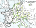 Carolingian Empire, now Western Empire treaty of Verdun AD843 splited the heritage between kin brothers.
 -

-
 Ye ole map of Saxon England, as seen from the Chronicle (not dated, ed. 1830)
 -
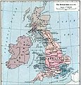
 Alfred the Great, facing a Danish invasion in 871, unites Heptarchy (in 30yrs). Birth of England, its medieval history starts.
See categ. + Fhoy Miore invasions of Ireland, 850 -
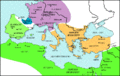
 Crowned 893 , tsar Simeon the Great expands his Bulgarian Empire.
 -
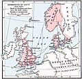
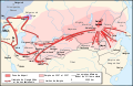
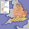 The Great Heathen Army of 865. Establishment of the Danelaw.
 -
 The Great Army of 892.
 -
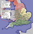 The Capture of the Danelaw by Wessex 902-920.
 -
 Scandinavian name places in England.
 -
 Map of Europe in 900
![Ostrogothic Kingdom during the reign of Theodoric. He took Italy from usurper Odoacer after a battle in 493. Formerly Ostrogoths were massed in diocesis Illyricum. [ locator ]](/wiki/File:Ostrogothic_Kingdom.png)


![Roman Hispania conquered at the death of Justinian, 565AD. [Category:Maps of Roman Hispania]](/wiki/File:Hispania_565.png)


![Identified powers in this World, around 820AD. [ use ].](/wiki/File:Old_World_820.png)


-TsarSimeon-byTodorBozhinov.png)


Maps after
[edit]- Note : fr - Moyen Âge central.
-

-
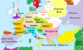
 Europe 998AD turned to be a "Christian West" in which millenarian fears have prevailed.
 -
-
 Political map of Europe 1000AD : though Speculation that the world will end in the year 1000 is confined to a few uneasy French monks, their views concerning An mil & later An de grâce (since the apocalypsis didn't came) became later dominant.
 -
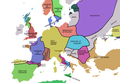
 Europe 1092AD High Middle Ages countries in Europe. See the difference with Late antiquity provinces
 -
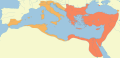
 1097 : situation of Europe at the First Crusade.
 -
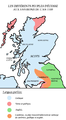 1100 : peoples dwelling in Scotland (Source map in English)
 -
![First founded crusader states in w:1100AD [ Commons category 12th century CE ]](https://upload.wikimedia.org/wikipedia/commons/thumb/3/36/Map_Crusader_states_ca._1100.jpg/49px-Map_Crusader_states_ca._1100.jpg) First founded crusader states in w:1100AD [ Commons category 12th century CE ]
First founded crusader states in w:1100AD [ Commons category 12th century CE ] -

-
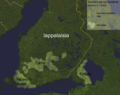 around 1150 : birth of Finland begin with various settlements
 -
 1142AD : left frame zooms on Frankish states in Levant, as were their fisrt names.
 -
 Northmannii settle kingdoms and pursue conquests for their own : in the 12th century, they founded the kingdom of Sicily (& later Napoli), taken from the Moors.
 -
 Known world as seen in 1154 by Al-Idrisi : works in Sicily & offers an atlas to his new northman ruler. Mappa Mundi still accurate til the Age of Discovery
 -
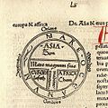 < COMPARISON Vision of Earth in the Middle Ages traces back to Isidore of Seville copies in monasteries. Still used in that first printed version, T and O map (Guntherus Ziner, Augsburg, 1472).
 -

-
 Gengis Khan empire - fr map


- Notes :
fr - Bas Moyen Âge.
en - Timeline voluntarily set apart from wikipedia article (see explanations above).
-
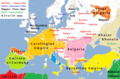
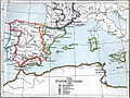 1360 : Castillan Reconquista, that just added Murcia taifa, pauses for a century ; Crown of Aragon completes its own Reconquista with Valencian territories. Sole kingdom of Granada remains Nasrid :
2 yrs later Muhammed V starts achieving the Alhambra. -
 Europe in 1370


See also
[edit]
Notes and references
[edit]|
General remarks:
|