Atlas of Madagascar

From Wikimedia Commons, the free media repository
Jump to navigation Jump to search
Wikimedia Commons Atlas of the World

The Wikimedia Atlas of the World is an organized and commented collection of geographical, political and historical maps available at Wikimedia Commons.
Discussion • Update the atlas • Index of the Atlas • Atlas in categories • Other atlases on line
The introductions of the country, dependency and region entries are in the native languages and in English. The other introductions are in English.
 
Atlas-country
Madagascar


Madagasikara
Madagascar

Malagasy Madagasikara - Repoblikan'i Madagasikara

Repoblikan'i Madagasikara dia tany (fitambarana nosy) eo amin'ny Ranomasimbe Indiana, atsinanan'i Afrika.

Français Madagascar - République de Madagascar

La République de Madagascar est un État insulaire, situé dans la partie occidentale de l'océan Indien, au large de l'Afrique de l'est dont il est séparé par le canal du Mozambique. Sa capitale est Antananarivo (Tananarive).

English 
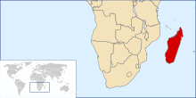
Madagascar - Republic of Madagascar

The Republic of Madagascar is an island nation in the Indian Ocean, off the southeastern coast of Africa, near ► Mozambique. It is surrounded by the island countries of ► Comoros, ► Mayotte (French), ► Seychelles, ► Réunion (French) and ► Mauritius. The main island, also called Madagascar, is the fourth largest island in the world, and is home to five percent of the world's plant and animal species (more than 80 percent of which are indigenous to Madagascar). Most notable are the lemur infraorder of primates, the carnivorous fossa, three endemic bird families and six endemic baobab species.


Short name  Madagascar
Official name Republic of Madagascar
Status Independent country since 1960
Location Southern Africa
Capital Antananarivo
Population 25,680,342 inhabitants
Area 597,041 square kilometres (230,519 sq mi)
Major languages Malagasy and French (both official)
Major religions Indigenous beliefs, Roman Catholicism, Protestantism
More information Madagascar, Geography of Madagascar, History of Madagascar and Politics of Madagascar
More images Madagascar - Madagascar (Category).

General maps

Carte de Madagascar
Map of Madagascar
Carte de Madagascar
Map of Madagascar (in French)
SVG outline map of Madagascar
Provinces de Madagascar
Provinces of Madagascar
Cartes topographiques de Madagascar
Topographic maps of Madagascar

Old maps

This section holds copies of original general maps more than 70 years old.

Carte de Madagascar depuis « Meyers Konversationslexikon » 1888
Map of Madagascar from Meyers Konversationslexikon, 1888

Other maps

Densité de la population
Population density

Satellite maps

Carte satellite (septembre 2003)
Satellite map
Carte satellite
satellite map

Notes and references

General remarks:

  • The WIKIMEDIA COMMONS Atlas of the World is an organized and commented collection of geographical, political and historical maps available at Wikimedia Commons. The main page is therefore the portal to maps and cartography on Wikimedia. That page contains links to entries by country, continent and by topic as well as general notes and references.
  • Every entry has an introduction section in English. If other languages are native and/or official in an entity, introductions in other languages are added in separate sections. The text of the introduction(s) is based on the content of the Wikipedia encyclopedia. For sources of the introduction see therefore the Wikipedia entries linked to. The same goes for the texts in the history sections.
  • Historical maps are included in the continent, country and dependency entries.
  • The status of various entities is disputed. See the content for the entities concerned.
  • The maps of former countries that are more or less continued by a present-day country or had a territory included in only one or two countries are included in the atlas of the present-day country. For example the Ottoman Empire can be found in the Atlas of Turkey.

Entries available in the atlas

General pages
World
Continents and oceans
Themes
Historical eras
States with wide recognition
States with limited recognition
Dependencies and other overseas territories
Country subdivisions
Belgium
China (mainland)
India
Pakistan
Spain
United Kingdom
United States
Other
Disputed subnational territories
Other regions
Cities
Former sovereign states
Former dependencies and overseas territories
Former disputed territories