The Republic of Namibia is a country in southern Africa on the Atlantic coast. It shares borders with ► Angola, and ► Zambia to the north, ► Botswana to the east, and ► South Africa to the south. It gained independence from South Africa in 1990 and its capital city is Windhoek.
Die Republiek van Namibië (vroeër bekend as Suidwes-Afrika) is 'n land in suidwestelike Afrika, aan die Atlantiese kus. Dit word deur Angola en Zambië in die noorde, Botswana in die weste, en Suid-Afrika in die suide begrens.
This section holds a short summary of the history of the area of present-day Namibia, illustrated with maps, including historical maps of former countries and empires that included present-day Namibia.
Plan Odendaal (1964)
SWAPO and South Africa Defence Force operations in Angola and Namibia, 1981-1984
Old maps
This section holds copies of original general maps more than 70 years old.
Historical map of the Cape States, Bibliothek allgemeinen und praktischen Wissens für Militäranwärter Band I, 190, Historiese kaart van die Kaap
German South West Africa in 1904, Duits Suidwest-Afrika in 1904
Homelands in 1978, Tuislande in 1978, "Reservate" in 1978
Distribution of Afrikaans in Namibia by Region 2011
Distribution of Afrikaans in Namibia
Distribution of Caprivi languages in Namibia
Distribution of Kavango languages in Namibia
Distribution of Nama (Damara) in Namibia
Distribution of Oshiwambo in Namibia
Distribution of Otjiherero in Namibia
Satellite maps
Satellite map, Satelietkaart, Satellitenkarte
Notes and references
General remarks:
The WIKIMEDIA COMMONS Atlas of the World is an organized and commented collection of geographical, political and historical maps available at Wikimedia Commons. The main page is therefore the portal to maps and cartography on Wikimedia. That page contains links to entries by country, continent and by topic as well as general notes and references.
Every entry has an introduction section in English. If other languages are native and/or official in an entity, introductions in other languages are added in separate sections. The text of the introduction(s) is based on the content of the Wikipedia encyclopedia. For sources of the introduction see therefore the Wikipedia entries linked to. The same goes for the texts in the history sections.
Historical maps are included in the continent, country and dependency entries.
The status of various entities is disputed. See the content for the entities concerned.
The maps of former countries that are more or less continued by a present-day country or had a territory included in only one or two countries are included in the atlas of the present-day country. For example the Ottoman Empire can be found in the Atlas of Turkey.


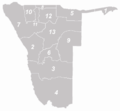 Regions of Namibia, Regio's van Namibië, Regionen in Namibia
 Regions and constituencies, Regionen und Wahlkreise
 Caprivi (1)
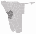 Erongo (2)
 Hardap (3)
 Karas (4)
 Kavango (5)
 Khomas (6)
 Kunene (7)
 Ohangwena (8)
 Omaheke (9)
 Omusati (10)
 Oshana (11)
 Oshikoto (12)
 Otjozondjupa (13)


_in_Namibia.png)


