Atlas of Guinea-Bissau

From Wikimedia Commons, the free media repository
Jump to navigation Jump to search
Wikimedia Commons Atlas of the World

The Wikimedia Atlas of the World is an organized and commented collection of geographical, political and historical maps available at Wikimedia Commons.
Discussion • Update the atlas • Index of the Atlas • Atlas in categories • Other atlases on line
The introductions of the country, dependency and region entries are in the native languages and in English. The other introductions are in English.
 
Atlas-country
Guinea-Bissau


Guiné-Bissau

Português Guiné-Bissau - República da Guiné-Bissau

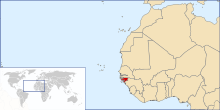
A República da Guiné-Bissau, com 36 125 km² de superfície, situa-se na Costa Ocidental de África, estendendo-se, no litoral, desde o Cabo Roxo até à ponta Cagete. Tem fronteira, a norte, com o Senegal, a este e sudeste com a Guiné e a sul e oeste com o Oceano Atlântico. Além do território continental, o país integra ainda cerca de 80 ilhas que constituem o arquipélago dos Bijagós, separado do Continente pelos canais do Geba, Pedro Álvares, Bolama e Canhabaque.

English Guinea-Bissau - Republic of Guinea-Bissau

The Republic of Guinea-Bissau is a country in western Africa, and one of the smallest nations in continental Africa. It is bordered by ► Senegal to the north, and ► Guinea to the south and east, with the Atlantic Ocean to its west. Formerly the Portuguese colony of Portuguese Guinea, upon independence, the name of its capital, Bissau, was added to the country's official name in order to prevent confusion between itself and the Republic of Guinea.


Short name  Guinea-Bissau
Official name Republic of Guinea-Bissau
Status Independent country since 1973, recognized 1974
Location West Africa
Capital Bissau
Population 1,520,830 inhabitants
Area 36,125 square kilometres (13,948 sq mi)
Major languages Portuguese (official), Kriol, Fula, Mandinka, Balanta
Major religions Animism, Islam, Catholicism
More information Guinea-Bissau, Geography of Guinea-Bissau, History of Guinea-Bissau and Politics of Guinea-Bissau
More images Guinea-Bissau - Guinea-Bissau (Category).

General maps

Map of Guinea-Bissau
Regions of Guinea-Bissau
Sectors of Guinea-Bissau

Satellite maps

Satellite map
Satellite map

Notes and references

General remarks:

  • The WIKIMEDIA COMMONS Atlas of the World is an organized and commented collection of geographical, political and historical maps available at Wikimedia Commons. The main page is therefore the portal to maps and cartography on Wikimedia. That page contains links to entries by country, continent and by topic as well as general notes and references.
  • Every entry has an introduction section in English. If other languages are native and/or official in an entity, introductions in other languages are added in separate sections. The text of the introduction(s) is based on the content of the Wikipedia encyclopedia. For sources of the introduction see therefore the Wikipedia entries linked to. The same goes for the texts in the history sections.
  • Historical maps are included in the continent, country and dependency entries.
  • The status of various entities is disputed. See the content for the entities concerned.
  • The maps of former countries that are more or less continued by a present-day country or had a territory included in only one or two countries are included in the atlas of the present-day country. For example the Ottoman Empire can be found in the Atlas of Turkey.

Entries available in the atlas

General pages
World
Continents and oceans
Themes
Historical eras
States with wide recognition
States with limited recognition
Dependencies and other overseas territories
Country subdivisions
Belgium
China (mainland)
India
Pakistan
Spain
United Kingdom
United States
Other
Disputed subnational territories
Other regions
Cities
Former sovereign states
Former dependencies and overseas territories
Former disputed territories