| |
|
Atlas-country

|
Norway
|
|
|
|
|
|
|
|
Norge / Noreg
|
|
|
|
| Norsk (Bokmål)
|
Norge - Kongeriket Norge
Kongeriket Norge er et skandinavisk land vest på den skandinaviske halvøy. Til lands grenser Norge mot Sverige, Finland og Russland i øst. Landet er langt og smalt, og kysten strekker seg langs Nordatlanteren med havområder som Skagerrak, Nordsjøen, Norskehavet og Barentshavet, hvor også Norges kjente fjorder befinner seg. Øya Jan Mayen i nordves.svgt er administrert som en del av hovedlandet og grenser til havs mot islandsk farvann. Øygruppen Svalbard er under norsk suverenitet med de begrensninger Svalbardtraktaten setter, men er i likhet med Jan Mayen en del av kongeriket. Bouvetøya i Sydatlanteren er derimot et norsk biland. Norge gjør også krav på Peter 1.s øy i det sørlige Stillehavet og territoriet Dronning Maud Land i Antarktis, men begge disse omfattes av Antarktis-traktaten, som legger territoriale krav i Antarktis på is. På grunn av uenighet om delelinjen mellom norsk og russisk territorialfarvann i Barentshavet, finnes det et område som inntil videre blir administrert av begge statene, det såkalte omstridte området.
|
| Norsk (Nynorsk)
|
Noreg - Kongeriket Noreg
Kongeriket Noreg er eit nordisk land vest på den skandinaviske halvøya. Til lands grenser Noreg mot Sverige i aust, Finland og Russland i nordaust, og til havs mot Danmark i sør og Storbritannia i sørvest. Noreg er langt og smalt, og kysten strekkjer seg langsmed Nordatlanteren med havområda Skagerrak, Nordsjøen, Norskehavet og Barentshavet. Den arktiske øygruppa Svalbard er under norsk suverenitet med dei avgrensingane som gjeld i Svalbardtraktaten, men Svalbard er til liks med øya Jan Mayen ein del av kongeriket. Bouvetøya i Søratlanteren er derimot eit norsk biland. Noreg gjer òg krav på Peter 1.s øy i det sørlege Stillehavet og territoriet Dronning Maud Land i Antarktis, men begge desse er omfatta av Antarktistraktaten som legg territoriale krav i Antarktis på is.
|
| Sámegiella
|
Norga - Norga gonagasriika
Norga gonagasriika lea riika Eurohpas. Norgga oaivegávpot lea Oslo. Norggas lea oktasaš eanarádji Ruoŧain, Suomain ja Ruošain ja mearrarádji Dánmárkkuin ja Ovttastuvvan gonagasriikkain.
|
| English
|
Norway - Kingdom of Norway
The Kingdom of Norway is a Nordic country on the western portion of the Scandinavian Peninsula, located in Europe, and bordering ► Sweden, ► Finland, and ► Russia. Norway has a very elongated shape; the country's extensive coastline along the North Atlantic Ocean is home to its famous fjords. The Kingdom of Norway also includes the Arctic island territories of ► Svalbard and ► Jan Mayen. Norwegian sovereignty over Svalbard is based on the Svalbard Treaty, but that treaty does not apply to Jan Mayen. ► Bouvet Island in the South Atlantic Ocean and a claim for Peter I Island in the South Pacific Ocean are also external dependencies, but these are not part of the Kingdom. Norway also claims Queen Maud Land in Antarctica, where it has established the Troll Permanent Research Station. To the west of Norway are located ► Iceland and the ► Faroe Islands.
|
|
|
|
| Short name
|
Norway
|
| Official name
|
Kingdom of Norway
|
| Status
|
Independent country since 1905
|
| Location
|
North Europe
|
| Capital
|
Oslo
|
| Population
|
5,372,355 inhabitants
|
| Area
|
385,180 square kilometres (148,720 sq mi)
|
| Languages
|
Norwegian (Bokmål and Nynorsk) (official), Sami
|
| Religions
|
Protestantism
|
| More information
|
Norway, Geography of Norway, History of Norway and Politics of Norway
|
| More images
|
Norway - Norway (Category).
|
|


 Nord-Norge
 Sørlandet
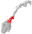 Trøndelag
 Vestlandet
 Østlandet


 Location of Innlandet
 Location of Møre og Romsdal
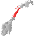 Location of Nordland
 Location of Oslo
 Location of Rogaland
 Location of Troms og Finnmark
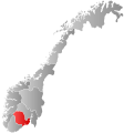 Location of Vestfold og Telemark
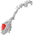 Location of Vestland
 Location of Viken


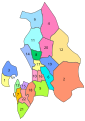 Akershus municipalities
 Aust-Agder municipalities
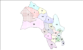 Buskerud municipalities
 Finnmark municipalities
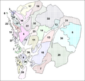 Hordaland municipalities
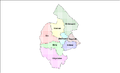 Jamtland municipalities
 More og Romsdal municipalities
 Nordland municipalities
 Nord-Trondelag municipalities
 Oppland municipalities
 Ostfold municipalities
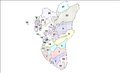 Rogaland municipalities
 Vest-Agder municipalities
 Vestfold municipalities


.PNG)


