Atlas of Haiti

From Wikimedia Commons, the free media repository
Jump to navigation Jump to search
Wikimedia Commons Atlas of the World

The Wikimedia Atlas of the World is an organized and commented collection of geographical, political and historical maps available at Wikimedia Commons.
Discussion • Update the atlas • Index of the Atlas • Atlas in categories • Other atlases on line
The introductions of the country, dependency and region entries are in the native languages and in English. The other introductions are in English.
 
Atlas-country
Haiti


Haïti
Ayiti

Français Haïti - République d'Haïti

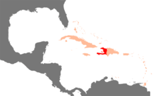
La République d'Haïti et un pays dans les Grandes Antilles. Haïti occupe le tiers occidental de l'île d'Hispaniola, en mer des Caraïbes, l'autre partie constituant le territoire de la République dominicaine. Port-au-Prince en est la capitale.

Krèyol ayisyen Ayiti - Repiblik Ayiti

Repiblik Ayiti se yon peyi ki sitye nan pati lwès zile Ispanyola nan lamè Karayib, lòt pati Ispanyola okipe pa Repiblik dominikèn. Kapital Ayiti se Pòtoprens. Ansyen non Ayiti se Sen Domeng Ansyen koloni Franse, se te youn nan premye peyi yo nan Amerik yo, apre Etazini, pou deklare endepandans. Se peyi pi pòv la nan emisfè lwès.

English Haiti - Republic of Haïti

The Republic of Haiti occupies three-eighths of the Caribbean island of Hispaniola. The country also includes many smaller islands such as La Gonâve, La Tortue (Tortuga), Les Cayemites, Île de Anacaona, and La Grande Caye. The uninhabited ► Navassa Island is claimed by both Haiti and the United States. 'Haiti' being the indigenous Taíno name for the island means "Land of big Mountains", and it is a very mountainous country. Its highest point is Chaine de la Selle, which has a height of 2,680 meters. Haiti shares the island of Hispaniola with the ► Dominican Republic. To the west of Haiti lies ► Cuba, to the north lie the ► Turks and Caicos Islands. The total area of Haiti is 27,750 km² (10,714 sq mi) and its capital is Port-au-Prince.


Short name  Haiti
Official name Republic of Haïti
Status Independent country since 1804
Location Caribbean
Capital Port-au-Prince
Pòtoprens
Population 11,743,017 inhabitants
Area 27,750 square kilometres (10,710 sq mi)
Major languages French, Haitian Creole (both official)
Major religions Roman Catholicism, Protestantism, Vodun
More information Haiti, Geography of Haiti, History of Haiti and Politics of Haiti
More images Haiti - Haiti (Category).

General maps

Carte administrative d'Haïti
Administrative map of Haiti
Topographic map in French
Carte topographique en français.
Carte routière d'Haïti
Road map of Haïti
Départements d'Haïti
Departments of Haiti
Départements d'Haïti
Departments of Haiti
Départements d'Haïti (en créole)
Departments of Haiti (in Haitian)
Arrondissements d'Haïti
Arrondissements of Haiti
Communes d'Haïti
Communes of Haiti
Topographie de Hispaniola
Topography of Hispaniola
Carte satellite d'Haïti
Satellite map

Old maps

This section holds copies of original general maps more than 70 years old.

Carte de Hispaniola du XV:e sièclex400px 98px

Notes and references

General remarks:

  • The WIKIMEDIA COMMONS Atlas of the World is an organized and commented collection of geographical, political and historical maps available at Wikimedia Commons. The main page is therefore the portal to maps and cartography on Wikimedia. That page contains links to entries by country, continent and by topic as well as general notes and references.
  • Every entry has an introduction section in English. If other languages are native and/or official in an entity, introductions in other languages are added in separate sections. The text of the introduction(s) is based on the content of the Wikipedia encyclopedia. For sources of the introduction see therefore the Wikipedia entries linked to. The same goes for the texts in the history sections.
  • Historical maps are included in the continent, country and dependency entries.
  • The status of various entities is disputed. See the content for the entities concerned.
  • The maps of former countries that are more or less continued by a present-day country or had a territory included in only one or two countries are included in the atlas of the present-day country. For example the Ottoman Empire can be found in the Atlas of Turkey.

Entries available in the atlas

General pages
World
Continents and oceans
Themes
Historical eras
States with wide recognition
States with limited recognition
Dependencies and other overseas territories
Country subdivisions
Belgium
China (mainland)
India
Pakistan
Spain
United Kingdom
United States
Other
Disputed subnational territories
Other regions
Cities
Former sovereign states
Former dependencies and overseas territories
Former disputed territories