Los Estados Unidos Mexicanos o comunmente México, es un país localizado en Norteamérica. Limita con Estados Unidos de América al norte, al sureste con Guatemala y Belice, al este con el golfo de México y el mar Caribe y al oeste con el océano Pacífico. En extensión territorial ocupa la quinta posición en el continente americano, y el décimo quinto a nivel mundial. Con una población aproximada de 106 millones, México es el segundo país más poblado de Latinoamérica y al mismo tiempo, el que tiene la mayor población indígena del continente americano. La sede de los poderes de la Federación y capital del país es México, Distrito Federal.
The United Mexican States or commonly Mexico is a country located in North America, bordered at the north by the ► United States, and at the south by Central America with ► Guatemala and ► Belize. To the west from Mexico ► Cuba and ► Jamaica are located. Its capital is Mexico City which is one of the largest cities on earth. Covering almost 2 million km² Mexico is one of the largest countries in America and the 15th in the world. It is also the 11th most populous country with approximately 106 million people and the most populous Spanish-speaking country in the world.
Short name
Mexico
Official name
United Mexican States
Status
Independent country since 1810, recognized 1821
Location
North America
Capital
Mexico City
Population
125,016,451 inhabitants
Area
1,972,550 square kilometres (761,610 sq mi)
Major languages
Spanish and 63 indigenous amerindian languages are national languages[1]
This section holds a short summary of the history of the area of present-day Mexico, illustrated with maps, including historical maps of former countries and empires that included present-day Mexico.
1840: Republic of the Rio Grande declared independence
1840: Republic of the Rio Grande rejoins Mexico
1842: Soconusco rejoins Mexico
1845: United States annexes Texas
1846: Yucatan declares independence
1848: Mexican Cession
1848: Yucatan rejoins Mexico
1853: United States buys Gadsden Purchase
1857: New constitution
1863: Champeche split from Yucatan
1864: Nuevo Leon split from Coahuila
1869: Hidalgo split from state of Mexico
1869: Morelo split from state of Mexico
1884: Tepic territory created
1902: Quintana Roo territory created
1917: Tepic become states of Nayarit
1931: Baja California Sur territory created
1952: Baja California becomes sta
1974: Baja California Sur and Quintana Roo become states
Old maps
This section holds copies of original general maps more than 70 years old.
Mexico in 1847
Other maps
Major volcanoes of Mexico
[[|border|251x400px]]
Languages of Mexico
Minor languages of Mexico
Population density
Electoral circonscriptions
State governments by party
Notes and references
General remarks:
The WIKIMEDIA COMMONS Atlas of the World is an organized and commented collection of geographical, political and historical maps available at Wikimedia Commons. The main page is therefore the portal to maps and cartography on Wikimedia. That page contains links to entries by country, continent and by topic as well as general notes and references.
Every entry has an introduction section in English. If other languages are native and/or official in an entity, introductions in other languages are added in separate sections. The text of the introduction(s) is based on the content of the Wikipedia encyclopedia. For sources of the introduction see therefore the Wikipedia entries linked to. The same goes for the texts in the history sections.
Historical maps are included in the continent, country and dependency entries.
The status of various entities is disputed. See the content for the entities concerned.
The maps of former countries that are more or less continued by a present-day country or had a territory included in only one or two countries are included in the atlas of the present-day country. For example the Ottoman Empire can be found in the Atlas of Turkey.


 1824: creating United Mexican States
 1824: Federal District created
 1824: Tlaxcala territory created
 1830: Sonora y Sinaloa split in two
 1835: Aguascalientes territory created
 1836: Texas declared independence
 1840: Republic of the Rio Grande declared independence
 1840: Republic of the Rio Grande rejoins Mexico
 1842: Soconusco rejoins Mexico
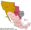 1845: United States annexes Texas
 1846: Yucatan declares independence
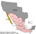 1848: Mexican Cession
 1848: Yucatan rejoins Mexico
 1853: United States buys Gadsden Purchase
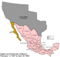 1857: New constitution
 1863: Champeche split from Yucatan
 1864: Nuevo Leon split from Coahuila
 1869: Hidalgo split from state of Mexico
 1869: Morelo split from state of Mexico
 1884: Tepic territory created
 1902: Quintana Roo territory created
 1917: Tepic become states of Nayarit
 1931: Baja California Sur territory created
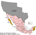 1952: Baja California becomes sta
 1974: Baja California Sur and Quintana Roo become states


