This section holds maps of the administrative divisions.
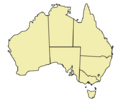
Map of Australian states and territories
Australia
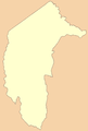
Australian Capital Territory
New South Wales
Northern Territory
Queensland
South Australia
Tasmania
Victoria
Western Australia
Australian Capital Territory
New South Wales
Northern Territory
Queensland
South Australia
Tasmania
Victoria
Western Australia
History maps
This section holds a short summary of the history of the area of present-day Australia, illustrated with maps, including historical maps of former countries and empires that included present-day Australia.
Australia discoveries by Europeans before 1813
In 1770 Captain James Cook rediscovers the region and claims it for Britain. This leads in 1778 to the formation of the colony of New South Wales. This map shows Australia as part of the British Empire.
In the upcoming decennia parts of the colony become separate colonies: Van Diemen's Land in 1825 (later named Tasmania), South Australia in 1836, New Zealand in 1841, Victoria in 1851 and Queensland in 1859. Many but by no means all of the first settlers are convicts, condemned for offenses that today would often be thought trivial. The mid-19th century brings government policies to emancipate convicts and the government assists the immigration of free persons. Since 1850 the colonies are granted self-government.
In 1891 a proces of re-unification starts, that leads in 1901 to the merger of the colonies of New South Wales, Queensland, South Australia, Tasmania, Victoria and West Australia into the Commonwealth of Australia, which becomes an independent country with a federal parliamentary democracy. Although Australia became independent in 1901, the British government keeps some powers on the country to the Treaty of Westminster, ratified in 1942. This map shows the development of the Australian states and territories since the Federation.
Census of 1921
Old maps
This section holds copies of original general maps more than 70 years old.
First map of Australia (Jave la Grande) from Nicholas Vallard's atlas, 1547
Le pôle antarctique, by Jacques de Vauxx, Premières Œuvres (traité d'hydrographie), 1583
Geographical distribution of the Queensland population self-identified as having Indigenous status (Aboriginal, Torres Strait Islanders or both) by Indigenous Locations (ILOC), according to the 2016 census
Geographical distribution of the Queensland population self-identified as having Indigenous status (Aboriginal, Torres Strait Islanders or both) by Local Government Areas (LGA), according to the 2016 census
Geographical distribution of the Queensland population self-identified as having Indigenous status (Aboriginal, Torres Strait Islanders or both) by State Suburbs (SSC), according to the 2016 census (uninhabited mesh blocks (MB) excluded)
Geographical distribution of the population self-identified as having Indigenous status (Aboriginals only) by Indigenous Locations (ILOC), according to the 2016 census
Geographical distribution of the Queensland population self-identified as having Indigenous status (Torres Strait Islanders only) by Indigenous Locations (ILOC), according to the 2016 census
Geographical distribution of the population self-identified as having both Aboriginal and Torres Strait Islander Indigenous status by Indigenous Locations (ILOC), according to the 2016 census
The prevalent 1st response about ancestry of the Queensland people self-identified as having Indigenous status (Aboriginal, Torres Strait Islanders or both) in Statistical Areas 1 (SA1) with more then 5% of Indigenous population
The languages most often spoken at home by people self-identified as having Indigenous status (Aboriginal, Torres Strait Islanders or both) in Statistical Areas 1 (SA1) with more then 5% of Indigenous population
Geographical distribution of the population self-identified as having Indigenous status (Aboriginal, Torres Strait Islanders or both) and spoken at home on one of Indigenous Australian languages by Statistical Areas 1 (SA1)
The prevalent religious affiliation of the people self-identified as having Indigenous status (Aboriginal, Torres Strait Islanders or both) in Statistical Areas 1 (SA1) with more then 5% of self-identified Indigenous population
Notes and references
General remarks:
The WIKIMEDIA COMMONS Atlas of the World is an organized and commented collection of geographical, political and historical maps available at Wikimedia Commons. The main page is therefore the portal to maps and cartography on Wikimedia. That page contains links to entries by country, continent and by topic as well as general notes and references.
Every entry has an introduction section in English. If other languages are native and/or official in an entity, introductions in other languages are added in separate sections. The text of the introduction(s) is based on the content of the Wikipedia encyclopedia. For sources of the introduction see therefore the Wikipedia entries linked to. The same goes for the texts in the history sections.
Historical maps are included in the continent, country and dependency entries.
The status of various entities is disputed. See the content for the entities concerned.
The maps of former countries that are more or less continued by a present-day country or had a territory included in only one or two countries are included in the atlas of the present-day country. For example the Ottoman Empire can be found in the Atlas of Turkey.

_-_AUS_-_UNOCHA.svg)


 Australia
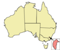 Australian Capital Territory
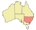 New South Wales
 Northern Territory
 Queensland
 South Australia
 Tasmania
 Victoria
 Western Australia


 Australian Capital Territory
 New South Wales
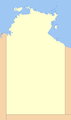 Northern Territory
 Queensland
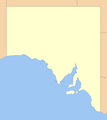 South Australia
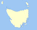 Tasmania
 Victoria
 Western Australia


 Geographical distribution of the Queensland population self-identified as having Indigenous status (Aboriginal, Torres Strait Islanders or both) by Indigenous Locations (ILOC), according to the 2016 census
 Geographical distribution of the Queensland population self-identified as having Indigenous status (Aboriginal, Torres Strait Islanders or both) by Local Government Areas (LGA), according to the 2016 census
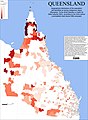 Geographical distribution of the Queensland population self-identified as having Indigenous status (Aboriginal, Torres Strait Islanders or both) by State Suburbs (SSC), according to the 2016 census (uninhabited mesh blocks (MB) excluded)
 Geographical distribution of the population self-identified as having Indigenous status (Aboriginals only) by Indigenous Locations (ILOC), according to the 2016 census
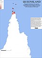 Geographical distribution of the Queensland population self-identified as having Indigenous status (Torres Strait Islanders only) by Indigenous Locations (ILOC), according to the 2016 census
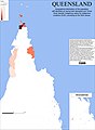 Geographical distribution of the population self-identified as having both Aboriginal and Torres Strait Islander Indigenous status by Indigenous Locations (ILOC), according to the 2016 census
 The prevalent 1st response about ancestry of the Queensland people self-identified as having Indigenous status (Aboriginal, Torres Strait Islanders or both) in Statistical Areas 1 (SA1) with more then 5% of Indigenous population
 The languages most often spoken at home by people self-identified as having Indigenous status (Aboriginal, Torres Strait Islanders or both) in Statistical Areas 1 (SA1) with more then 5% of Indigenous population
 Geographical distribution of the population self-identified as having Indigenous status (Aboriginal, Torres Strait Islanders or both) and spoken at home on one of Indigenous Australian languages by Statistical Areas 1 (SA1)
 The prevalent religious affiliation of the people self-identified as having Indigenous status (Aboriginal, Torres Strait Islanders or both) in Statistical Areas 1 (SA1) with more then 5% of self-identified Indigenous population


