Greece (officially the Hellenic Republic) , is a country in south-eastern Europe, situated on the southern end of the Balkan peninsula. It is bordered by ► Bulgaria, the ► North Macedonia, ► Albania to the north, and by ► Turkey to the east. The Aegean Sea lies to the east of mainland Greece, while the Ionian Sea lies to the west. Both parts of the eastern Mediterranean basin feature a vast number of islands. Greece includes the autonomous monastic republic of ► Athos.
Ελληνικά
Η Ελλάδα (ή Ελλάς, επίσημη ονομασία Ελληνική Δημοκρατία), είναι χώρα στην νοτιοανατολική Ευρώπη, στο νοτιότερο άκρο της Βαλκανικής χερσονήσου, στην Ανατολική Μεσόγειο. Συνορεύει στην ξηρά, βόρεια με την ► ΠΓΔΜ και την ► Βουλγαρία , στα βορειοδυτικά με την ► Αλβανία και στα βορειοανατολικά με την ► Τουρκία. Βρέχεται ανατολικά από το Αιγαίο Πέλαγος, στα δυτικά και νότια από το Ιόνιο και από την Μεσόγειο Θάλασσα. Θεωρείται λίκνο του Δυτικού πολιτισμού. Η Ελλάδα έχει μια μακρά και πλούσια ιστορία κατά την οποία άσκησε μεγάλη πολιτισμική επίδραση σε τρεις ηπείρους. Στην Ελλάδα ανήκει και η ► Αθωνική Πολιτεία του Αγίου Όρους.
Short name
Greece
Official name
Hellenic Republic
Status
Independent country since 1821, member of the ► European Union since 1981
This section holds a short summary of the history of the area of present-day Greece, illustrated with maps, including historical maps of former countries and empires that included present-day Greece.
Roman Empire divided 395, showing the dioceses and praetorian prefectures of Gaul, Italy, Illyricum and Oriens (east), roughly analogous to the four Tetrarch zones of influence after Diocletian's reforms.
The division of the Empire after the death of Theodosius I, ca.395 AD superimposed on modern borders.
Map of the two orthodox patriarcates of Athens (blue) and Constantinople (orange, yellow)
Map of Corinthian Isthmus, German, as well as SVG-Version
Satellite maps
Satellite map of Greece
Satellite map of Greece
Notes and references
General remarks:
The WIKIMEDIA COMMONS Atlas of the World is an organized and commented collection of geographical, political and historical maps available at Wikimedia Commons. The main page is therefore the portal to maps and cartography on Wikimedia. That page contains links to entries by country, continent and by topic as well as general notes and references.
Every entry has an introduction section in English. If other languages are native and/or official in an entity, introductions in other languages are added in separate sections. The text of the introduction(s) is based on the content of the Wikipedia encyclopedia. For sources of the introduction see therefore the Wikipedia entries linked to. The same goes for the texts in the history sections.
Historical maps are included in the continent, country and dependency entries.
The status of various entities is disputed. See the content for the entities concerned.
The maps of former countries that are more or less continued by a present-day country or had a territory included in only one or two countries are included in the atlas of the present-day country. For example the Ottoman Empire can be found in the Atlas of Turkey.


.svg)
.svg)


.svg)

.svg)
.png)

.svg)


.svg)

_en.svg)


.svg)
.svg)


.svg)
.jpg)
_(English).svg)
_(English).svg)


.svg)


.svg)
_no_region_markers.svg)
.svg)


_(English).jpg)


.PNG)


.PNG)


.jpg)
.jpg)


.png)
.jpg)


 Αττική (Attiki)English: Attica
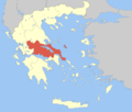 Στερεά Ελλάδα (Sterea Ellada)English: Central Greece
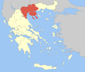 Κεντρική Μακεδονία (Kentriki Makedonia)English: Central Macedonia
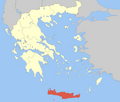 Κρήτη (Kriti)English: Crete
 Ανατολική Μακεδονία και Θράκη (Anatoliki Makedonia kai Thraki)English: East Macedonia and Thrace
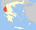 Ήπειρος (Ipiros)English: Epirus
 Ιόνια Νησιά (Ionia Nisia)English: Ionian Islands
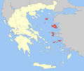 Βόρειο Αιγαίο (Voreio Aigaio)English: North Aegean
 Πελοπόννησος (Peloponnisos)English: Peloponnesus
 Νότιο Αιγαίο (Notio Aigaio)English: South Aegean
 Θεσσαλία (Thessalia)English: Thessaly
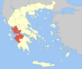 Δυτική Ελλάδα (Dytiki Ellada)English: Western Greece
 Δυτική Μακεδονία (Dytiki Makedonia)English: West Macedonia


 Αιτωλοακαρνανία (Aitoloakarnania)English: Aetolia-Acarnania
 Αθήνα (Athina)English: Athens
 Ανατολική Αττική (Anatoliki Attiki)English: East Attica
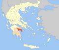 Αργολίδα (Argolida) (alt. Argolis)
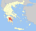 Αρκαδία (Arkadia)
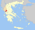 Άρτα (Arta)
 Αχαΐα (Achaia)
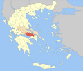 Βοιωτία (Voiotia)English: Boeotia
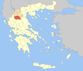 Γρεβενά (Grevena)
 Δράμα (Drama)
 Δωδεκάνησος (Dodekanisos)English: Dodecanese
 Δυτική Αττική (Dytiki Attiki)English: West Attica
 Εύβοια (Evvoia)English: Euboea
 Έβρος (Evros)
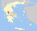 Ευρυτανία (Evrytania)
 Ζάκυνθος (Zakynthos)
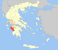 Ηλεία (Ileia)English: Elis
 Ημαθία (Imathia)
 Ηράκλειο (Iraklio)English: Heraklion
 Θεσπρωτία (Thesprotia)
 Θεσσαλονίκη (Thessaloniki)
 Ιωάννινα (Ioannina)
 Καβάλα (Kavala)
 Καρδίτσα (Karditsa)
 Καστοριά (Kastoria)
 Κέρκυρα (Kerkyra)English: Corfu
 Κεφαλληνία και Ιθάκη (Kefallinia kai Ithaki)English: Kafalonia and Ithaca
 Κοζάνη (Kozani)
 Κορινθία (Korinthia)English: Corinthia
 Κιλκίς (Kilkis)
 Κυκλάδες (Kyklades)English: Cyclades
 Λακωνία (Lakonia)English: Laconia
 Λάρισα (Larisa)
 Λασίθι (Lasithi)
 Λευκάδα (Lefkada) (alt. Lefkas)
 Μαγνησία (Magnisia)English: Magnesia
 Μεσσηνία (Messinia)English: Messenia
 Πέλλα (Pella)
 Πιερία (Pieria)
 Πειραιάς (Peiraias)English: Piraeus
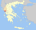 Πρέβεζα (Preveza)
 Ρέθυμνο (Rethymno)
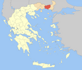 Ροδόπη (Rodopi)English: Rhodope
 Σάμος (Samos)
 Σέρρες (Serres)
 Ξάνθη (Xanthi)
 Τρίκαλα (Trikala)
 Φλώρινα (Florina)
 Φθιώτιδα (Fthiotida)English: Phthiotis
 Φωκίδα (Fokida)English: Phocis
 Χαλκιδική (Chalkidiki)
 Χανιά (Chania)
 Χίος (Chios)


