El Estado Plurinacional de Bolivia es un país ubicado en el centro de América del Sur. Sus capitales son las ciudades de La Paz (sede de gobierno) y Sucre (constitucional). En extensión territorial ocupa la octava posición en el continente americano, y el vigésimo séptimo a nivel mundial. Limita al norte y al este con Brasil, al sur con Paraguay y Argentina , y al oeste con Chile y el Perú. Su capital es Sucre y su sede de gobierno es La Paz. Fue fundada inicialmente con el nombre de "República Bolívar" en honor a su libertador.
The Plurinational State of Bolivia, named after Simón Bolívar, is a landlocked country in central South America. It is bordered by ► Brazil on the north and east, ► Paraguay and ► Argentina on the south, and ► Chile and ► Peru on the west.
Short name
Bolivia
Official name
Plurinational State of Bolivia
Status
Independent country since 1825
Location
South America
Capital
Sucre
Population
11,633,371 inhabitants
Area
1,098,581 square kilometres (424,164 sq mi)
Major languages
Spanish, Quechua, Aymara, Guaraní, and 33 other indigenous languages (all official)
This section holds a short summary of the history of the area of present-day Bolivia, illustrated with maps, including historical maps of former countries and empires that included present-day Bolivia.
The WIKIMEDIA COMMONS Atlas of the World is an organized and commented collection of geographical, political and historical maps available at Wikimedia Commons. The main page is therefore the portal to maps and cartography on Wikimedia. That page contains links to entries by country, continent and by topic as well as general notes and references.
Every entry has an introduction section in English. If other languages are native and/or official in an entity, introductions in other languages are added in separate sections. The text of the introduction(s) is based on the content of the Wikipedia encyclopedia. For sources of the introduction see therefore the Wikipedia entries linked to. The same goes for the texts in the history sections.
Historical maps are included in the continent, country and dependency entries.
The status of various entities is disputed. See the content for the entities concerned.
The maps of former countries that are more or less continued by a present-day country or had a territory included in only one or two countries are included in the atlas of the present-day country. For example the Ottoman Empire can be found in the Atlas of Turkey.


 Departments of Bolivia
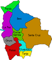 Departments of Bolivia
 Beni
Beni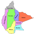 Beni provinces
 Chuquisaca
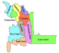 Chuquisaca provinces
 Cochabamba
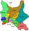 Cochabamba provinces
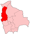 La Paz
 La Paz provinces
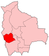 Oruro
Oruro Oruro provinces
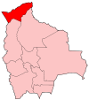 Pando
Pando Pando provinces
 Potosi
 Potosí provinces
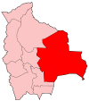 Santa Cruz
 Santa Cruz provinces
 Tarija
 Tarija provinces


.svg)


.svg)


