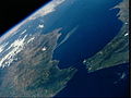
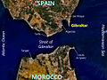
Gibraltar is a UK overseas territory located near the southernmost tip of the Iberian Peninsula, overlooking the Strait of Gibraltar. The territory shares a land border with the province of Cádiz in ► Andalusia, ► Spain to the north. To the south lies ► Morocco. Gibraltar has historically been an important base for the British Armed Forces and is the site of a British naval base. It is probably most famous for the geological formation, the Rock of Gibraltar.
Short name
Gibraltar
Official name
Gibraltar
Status
► British overseas territory, British since 1704, recongized in 1713, but claimed by Spain
This section holds a short summary of the history of the area of present-day Gibraltar, illustrated with maps, including historical maps of former countries and empires that included present-day Gibraltar.
Historical map of the promontory of Gibraltar, Meyers Konversationslexikons (1885-90)
The WIKIMEDIA COMMONS Atlas of the World is an organized and commented collection of geographical, political and historical maps available at Wikimedia Commons. The main page is therefore the portal to maps and cartography on Wikimedia. That page contains links to entries by country, continent and by topic as well as general notes and references.
Every entry has an introduction section in English. If other languages are native and/or official in an entity, introductions in other languages are added in separate sections. The text of the introduction(s) is based on the content of the Wikipedia encyclopedia. For sources of the introduction see therefore the Wikipedia entries linked to. The same goes for the texts in the history sections.
Historical maps are included in the continent, country and dependency entries.
The status of various entities is disputed. See the content for the entities concerned.
The maps of former countries that are more or less continued by a present-day country or had a territory included in only one or two countries are included in the atlas of the present-day country. For example the Ottoman Empire can be found in the Atlas of Turkey.


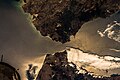
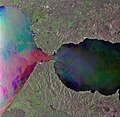
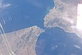
 Satellite map of Gibraltar
 Satellite map of Gibraltar
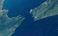
 Satellite map of Gibraltar


.jpg)
_-_2.jpg)
.jpg)
.jpg)


.jpg)


.jpg)


.jpg)