La République Togolaise' est un pays d’Afrique de l'Ouest ayant des frontières communes avec le Bénin à l’est, le Burkina Faso au nord, et le Ghana à l’ouest. Sa façade sud est ouverte sur le golfe du Bénin. La population est estimée en 2006 à environ 5,4 millions d’habitants pour une densité de 95 hab/km².
The Togolese Republic is a country in West Africa bordering ► Ghana in the west, ► Benin in the east and ► Burkina Faso in the north. In the south, it has a short Gulf of Guinea coast, on which the capital Lomé is located.
Political map of Togo, Savannes marked (in German)
Prefectures of Savannes
Kara region
Political map of Togo, Kara marked (in German)
Prefectures of Kara
Centrale region
Political map of Togo, Centrale marked (in German)
Prefectures of Centrale
Plateaux region
Political map of Togo, Plateaux marked (in German)
Prefectures of Plateaux
Maritime region
Political map of Togo, Maritime marked (in German)
Prefectures of Maritime
History maps
This section holds a short summary of the history of the area of present-day Togo, illustrated with maps, including historical maps of former countries and empires that included present-day Togo.
Division du Togo en 1918 Division of Togo in 1918
Old maps
This section holds copies of original general maps more than 70 years old.
The WIKIMEDIA COMMONS Atlas of the World is an organized and commented collection of geographical, political and historical maps available at Wikimedia Commons. The main page is therefore the portal to maps and cartography on Wikimedia. That page contains links to entries by country, continent and by topic as well as general notes and references.
Every entry has an introduction section in English. If other languages are native and/or official in an entity, introductions in other languages are added in separate sections. The text of the introduction(s) is based on the content of the Wikipedia encyclopedia. For sources of the introduction see therefore the Wikipedia entries linked to. The same goes for the texts in the history sections.
Historical maps are included in the continent, country and dependency entries.
The status of various entities is disputed. See the content for the entities concerned.
The maps of former countries that are more or less continued by a present-day country or had a territory included in only one or two countries are included in the atlas of the present-day country. For example the Ottoman Empire can be found in the Atlas of Turkey.


 Savannes region
 Political map of Togo, Savannes marked (in German)
 Prefectures of Savannes

 Kara region
 Political map of Togo, Kara marked (in German)
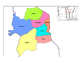 Prefectures of Kara

 Centrale region
 Political map of Togo, Centrale marked (in German)
 Prefectures of Centrale

 Plateaux region
 Political map of Togo, Plateaux marked (in German)
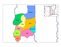 Prefectures of Plateaux

 Maritime region
 Political map of Togo, Maritime marked (in German)
 Prefectures of Maritime


