Рэспубліка Беларусь — краіна ва Усходняй Еўропе, буйнейшая па тэрыторыі ў Еўропе краіна бяз выхаду да мора. Мяжуе з Польшчай на захадзе, Лiтвой на паўночным захадзе, Латвіяй на поўначы, Расiяй на ўсходзе і Украінай на поўдні.
Республика Беларусь, Белору́ссия — государство в Восточной Европе, с 2 апреля 1997 член Союза России и Белоруссии. В 1922—1991 бывшая Белорусская Советская Социалистическая Республика была членом-учредителем СССР. Страна также является членом-учредителем ООН, СНГ, ОДКБ, Евразэса, а также членом других международных объединений.
The Republic of Belarus is a landlocked country in Eastern Europe, bordering ► Russia, ► Ukraine, ► Poland, ► Lithuania, and ► Latvia. Its capital is Minsk, and other important cities include Brest, Grodno, Gomel, Mogilev and Vitebsk. One third of the country's surface is covered in forests.
Administrative divisions of Belarus (with numbers)
Administrative regions
Brest region (Брэсцкая вобласць)
Homyel region (Гомельская вобласць)
Hrodna region (Гродзенская вобласць)
Mahilyow region (Магілёўская вобласць)
Minsk region (Мiнская вобласць)
Vitsebsk region (Віцебская вобласць)
History maps
This section holds a short summary of the history of the area of present-day Belarus, illustrated with maps, including historical maps of former countries and empires that included present-day Belarus.
Possible extent of (proto-)Celtic influence 800-400 BC
Celts in Europe
Proto-Germanic people's
Map showing the pre-Migration Age distribution of the Germanic tribes in Proto-Germanic times, and stages of their expansion up to 50 BC, AD 100 and AD 300.
State of the Antes in the 6th century (around 560), according to the book of Francis Dvornik
Early Rus'
Varangian routes
Map showing changes in borders of the Mongol Empire from founding by Genghis Khan in 1206, Genghis Khan's death in 1227 to the rule of Kublai Khan (1260–1294). (Uses modern day borders)
Map showing changes in the territory of Lithuania including present-day Belarus from the 13th century to the present day
Lithuania in the 13th and 15th century
Map of Lithuania
In 1386 Poland and Lithuania formed a Polish-Lithuanian personal union, succeeded in 1569 by the Polish-Lithuanian Commonwealth. Large parts of present-day Belarus and Ukraine were part of Poland-Lithuania. This map shows the borders in 1466
Polish-Lithuanian Commonwealth 1569
Location of the Polish Lithuanian Commonwealth
Polish Lithuanian Commonwealth compared with present borders
Polish Lithuanian Commonwealth
Polish-Swedish Union 1592-1599
Commonwealth 1600
Commonwealth 1635
Commonwealth 1658
Commonwealth 1686
Commonwealth, division in voivodships
Commonwealth 1701
Commonwealth 1701
7 years war 1756-1762
The divisions of the Commonwealth
Commonwealth after 1st partition
Polish-Russian War 1792
Commonwealth after 2nd partition
Poland 1794
The third partition meant the end of the Polish-Lithuanian Commonwealth and the final division between Prussia, Russia and Austria after 3rd partition
The WIKIMEDIA COMMONS Atlas of the World is an organized and commented collection of geographical, political and historical maps available at Wikimedia Commons. The main page is therefore the portal to maps and cartography on Wikimedia. That page contains links to entries by country, continent and by topic as well as general notes and references.
Every entry has an introduction section in English. If other languages are native and/or official in an entity, introductions in other languages are added in separate sections. The text of the introduction(s) is based on the content of the Wikipedia encyclopedia. For sources of the introduction see therefore the Wikipedia entries linked to. The same goes for the texts in the history sections.
Historical maps are included in the continent, country and dependency entries.
The status of various entities is disputed. See the content for the entities concerned.
The maps of former countries that are more or less continued by a present-day country or had a territory included in only one or two countries are included in the atlas of the present-day country. For example the Ottoman Empire can be found in the Atlas of Turkey.


 Administrative regions
 Brest region (Брэсцкая вобласць)
 Homyel region (Гомельская вобласць)
 Hrodna region (Гродзенская вобласць)
 Mahilyow region (Магілёўская вобласць)
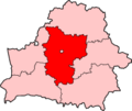 Minsk region (Мiнская вобласць)
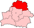 Vitsebsk region (Віцебская вобласць)


.PNG)


.png)
_rus.png)


_Map_1918.jpg)
