Atlas of Somaliland

From Wikimedia Commons, the free media repository
Jump to navigation Jump to search
Wikimedia Commons Atlas of the World

The Wikimedia Atlas of the World is an organized and commented collection of geographical, political and historical maps available at Wikimedia Commons.
Discussion • Update the atlas • Index of the Atlas • Atlas in categories • Other atlases on line
The introductions of the country, dependency and region entries are in the native languages and in English. The other introductions are in English.
 
Atlas-country
Somaliland


Soomaaliland
جمهورية أرض الصومال

Soomaaliga Soomaaliland - Jamhuuriyadda Soomaaliland

Jamhuuriyadda Soomaaliland Somaliland waa dal ku yaal bariga Afrika, Geeska Afrika, kuna yaal xeebta koonfureed ee Gacanka Cadmeed. Waxay xuduud la wadaagtaa dhinaca waqooyi oo ay la wadaagto dawladda Jabuuti. Konfur iyo barriba Soomaaliya iyo galbeedba Itoobiya. Ma jiro dal si rasmi ah u aqoonsanaya jiritaankiisa, inkasta oo Jamhuuriyadda Somaliland ay ku dhisan tahay dhulka, marka laga hadlayo baarlamaanka, xukuumada, ciidamada iyo siyaasadda gudaha iyo dibadda.

العربية [1]جمهورية أرض الصومال - جمهورية ارض الصومال


جمهورية أرض الصومال هي دولة تقع في شرق افريقيا منطقة القرن الافريقي مطلة على الشاطئ الجنوبي خليج عدن . لها حدود مشتركة من الشمال مع دولة جيبوتي. من الجنوب و الشرق مع الصومال و من الغرب مع إثيوبيا. لا يوجد أي دولة تعترف رسميا بوجودها مع أن جمهورية أرض الصومال قائمة على أرض الواقع، من حيث البرلمان، الإدارة، القوات و السياسة الداخلية و الخارجية.

English Somaliland - Republic of Somaliland

The Republic of Somaliland (Soomaaliland, أرض الصومال Arḍ aṣ-Ṣūmāl) is an unrecognized de facto sovereign state located in the Horn of Africa. In May 18, 1991, Somaliland declared independence from ► Somalia. The Republic of Somaliland claims to include six administrative regions with governor as highest ranking leader of each region. The Republic of Somaliland considers itself to be the successor state of the former British Somaliland protectorate. The area encompasses roughly the former British Somaliland protectorate, an area of about 176,120 square kilometres (68,000 sq mi), which was briefly an independent country for five days in June 26, 1960. It is bordered by ► Ethiopia on the south, ► Djibouti on the west, the Gulf of Aden on the north, and the Puntland state of Somalia on the east. It has maritime borders with ► Yemen. The capital of Somaliland is Hargeisa.


Short name  Somaliland
Official name Republic of Somaliland
Status Withdrawal from a political union with the trust territory of Somalia Italiana in 1991
Location Horn of Africa
Capital Hargeisa
Population 5,700,000 (Est. 2021) inhabitants
Area 176,120 square kilometres (68,000 sq mi)
Major languages Somali, Arabic, and English (all official)
Major religions Islam and Traditional Religions
More information Somaliland, Geography of Somaliland, History of Somaliland and Politics of Somaliland
More images Somaliland - Somaliland (Category).

General maps

Geographic map of Somaliland
Blank map of Somaliland
Blank districts map of Somaliland
Map of Somaliland
Map of Somaliland
Map of Somaliland
Location map of Somaliland

History maps

This section holds a short summary of the history of the area of present-day Somaliland, illustrated with maps, including historical maps of former countries and empires that included present-day Somaliland.

Gulf of Aden and the Somaliland, 1860
Colonial partition of the Horn of Africa around 1900
1906 Map of a portion of Somaliland
Somaliland Italian invasion WWII
Map of Somaliland
Flag map of Somaliland
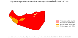
Köppen–Geiger climate classification map for Somaliland
Current political situation in Somalia
Map of Somaliland Somaliland physical map.
Regions of Somaliland
Somaliland regions (numbered)
Somaliland administrative divisions, regions and districts

Satellite maps

Satellite map

Notes and references

General remarks:

  • The WIKIMEDIA COMMONS Atlas of the World is an organized and commented collection of geographical, political and historical maps available at Wikimedia Commons. The main page is therefore the portal to maps and cartography on Wikimedia. That page contains links to entries by country, continent and by topic as well as general notes and references.
  • Every entry has an introduction section in English. If other languages are native and/or official in an entity, introductions in other languages are added in separate sections. The text of the introduction(s) is based on the content of the Wikipedia encyclopedia. For sources of the introduction see therefore the Wikipedia entries linked to. The same goes for the texts in the history sections.
  • Historical maps are included in the continent, country and dependency entries.
  • The status of various entities is disputed. See the content for the entities concerned.
  • The maps of former countries that are more or less continued by a present-day country or had a territory included in only one or two countries are included in the atlas of the present-day country. For example the Ottoman Empire can be found in the Atlas of Turkey.
  1. Romanization: Ard as-Sūmāl - (Jumhūrīyat Ard as-Sūmāl.

Entries available in the atlas

General pages
World
Continents and oceans
Themes
Historical eras
States with wide recognition
States with limited recognition
Dependencies and other overseas territories
Country subdivisions
Belgium
China (mainland)
India
Pakistan
Spain
United Kingdom
United States
Other
Disputed subnational territories
Other regions
Cities
Former sovereign states
Former dependencies and overseas territories
Former disputed territories


Other maps

Ethnic groups, 2002

Notes and references

General remarks:

  • The WIKIMEDIA COMMONS Atlas of the World is an organized and commented collection of geographical, political and historical maps available at Wikimedia Commons. The main page is therefore the portal to maps and cartography on Wikimedia. That page contains links to entries by country, continent and by topic as well as general notes and references.
  • Every entry has an introduction section in English. If other languages are native and/or official in an entity, introductions in other languages are added in separate sections. The text of the introduction(s) is based on the content of the Wikipedia encyclopedia. For sources of the introduction see therefore the Wikipedia entries linked to. The same goes for the texts in the history sections.
  • Historical maps are included in the continent, country and dependency entries.
  • The status of various entities is disputed. See the content for the entities concerned.
  • The maps of former countries that are more or less continued by a present-day country or had a territory included in only one or two countries are included in the atlas of the present-day country. For example the Ottoman Empire can be found in the Atlas of Turkey.

Entries available in the atlas

General pages
World
Continents and oceans
Themes
Historical eras
States with wide recognition
States with limited recognition
Dependencies and other overseas territories
Country subdivisions
Belgium
China (mainland)
India
Pakistan
Spain
United Kingdom
United States
Other
Disputed subnational territories
Other regions
Cities
Former sovereign states
Former dependencies and overseas territories
Former disputed territories


References