Category:Aerial photographs of Fukui prefecture
Jump to navigation
Jump to search

Media in category "Aerial photographs of Fukui prefecture"
The following 51 files are in this category, out of 51 total.
-
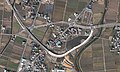
 Aerial photographs of Oi-Takahama interchange.jpg 1,200 × 600; 626 KB
-
 Aerial photographs of Ono interchange, Fukui.jpg 2,000 × 1,200; 1.62 MB
-
 Akao Otsutsumi water reservoir Aerial photograph.1977.jpg 1,138 × 832; 381 KB
-
 Ao-Shima Island Obama, Fukui Aerial Photograph.jpg 1,476 × 1,967; 831 KB
-
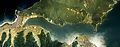 Aoto-no-irie Bay Aerial photograph.1975.jpg 7,883 × 3,055; 17.38 MB
-
 Awara Golf Club, Awara Fukui Aerial photograph.2008.jpg 3,322 × 4,429; 5.63 MB
-
 EC-Eiheiji-guchi Station-Aerial photography 1948.jpg 1,079 × 903; 596 KB
-
 EchizenKaigan.jpg 1,280 × 960; 202 KB
-
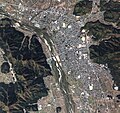
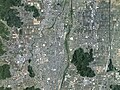
 Fukui city aerial 01.jpg 3,008 × 2,000; 1,010 KB
-
 Fukui city aerial 02.jpg 3,008 × 2,000; 1.2 MB
-
 Fukui city aerial 03.jpg 3,000 × 1,996; 1.4 MB
-
 Fukui city aerial 04.jpg 3,008 × 2,000; 1.2 MB
-
 Fukui city center area Aerial photograph.1975.jpg 6,894 × 6,787; 41.14 MB
-
 Fukui city center area Aerial photograph.2021.jpg 13,839 × 14,999; 155.21 MB
-
 Fukui Prefectural Hospital sky.JPG 2,816 × 2,112; 1.56 MB
-
 Fukui prefectural office sky.JPG 3,648 × 2,736; 5.43 MB
-
 Fukui prison - aerial photograph.jpg 600 × 450; 228 KB
-
 Fukui-Izumi ski resort.jpg 2,177 × 1,156; 2.42 MB
-
 Hakusan Train Depot.jpg 2,308 × 1,536; 906 KB
-
 Hayase aerial photograph 2013.jpg 1,264 × 948; 292 KB
-
 Hiruga aerial photograph 2018.jpg 2,904 × 1,936; 2.06 MB
-
 Jr west fukui station sky.JPG 2,272 × 1,704; 1.53 MB
-
 Katsuyama city center area Aerial photograph.1977.jpg 4,381 × 3,438; 10.7 MB
-
 Katsuyama city center area Aerial photograph.2014.jpg 8,740 × 8,216; 54.24 MB
-
 Kumagawa-juku post town district Aerial photograph.1975.jpg 3,002 × 2,172; 6.7 MB
-
 Kuzuryu Dam Lake Aerial photograph.1977.jpg 8,190 × 4,271; 31.61 MB
-
 Lake Kitagata Lagoon Aerial photograph.2008.jpg 6,142 × 7,644; 15.92 MB
-
 Mikata five lakes Aerial photograph.1975.jpg 3,427 × 4,999; 11.98 MB
-
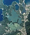 Mikata five lakes Aerial photograph.2018.jpg 11,051 × 12,950; 48.61 MB
-
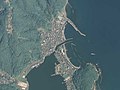
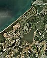
 Mizushima Island Tsuruga, Fukui Aerial Photograph.jpg 1,495 × 1,084; 391 KB
-
 Obama city center area Aerial photograph.1975.jpg 5,067 × 3,485; 12.55 MB
-
 Obama city center area Aerial photograph.2013.jpg 5,445 × 6,824; 30.15 MB
-
 Obama City General Ground.jpg 1,506 × 1,001; 662 KB
-
 Ohara Dam lake (Katsuyama, Fukui) 1977.jpg 436 × 326; 58 KB
-
 Oi NPP 1975.jpg 1,918 × 1,436; 503 KB
-
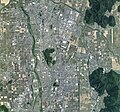
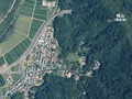
 Ono Basin in Winter.jpg 1,530 × 861; 344 KB
-
 Ono, Fukui prefecture city center area Aerial photograph.1977.jpg 5,819 × 5,055; 25.21 MB
-
 Ono, Fukui prefecture city center area Aerial photograph.2014.jpg 8,781 × 8,172; 53.98 MB
-
 Sabae city center area Aerial photograph.1975.jpg 5,527 × 3,575; 14.04 MB
-
 Sabae city center area Aerial photograph.2021.jpg 12,165 × 11,404; 95.73 MB
-
 Sagaki aerial photograph 2018.png 1,613 × 1,206; 4.84 MB
-

-
 Takefu district Echizen city Aerial photograph.1975.jpg 5,288 × 5,494; 25.48 MB
-
 Takefu district Echizen city Aerial photograph.2021.jpg 12,038 × 9,015; 74.3 MB
-
 Tojinbo 2008-04-30.jpg 1,602 × 1,202; 1.71 MB
-
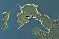
 Tsunegami Peninsula Aerial photograph.1975.jpg 7,181 × 6,626; 20.35 MB
-
 Tsunegami Peninsula Aerial photograph.2013.jpg 5,413 × 6,149; 4.4 MB
-
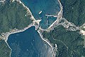
 Tsunekami fishing port town Aerial photograph.2018.jpg 5,549 × 3,699; 3.67 MB
-
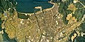 Tsuruga city center area Aerial photograph.1975.jpg 6,818 × 3,432; 17.11 MB
-
 Tsuruga city center area Aerial photograph.2013.jpg 6,383 × 6,327; 35.86 MB
-
 USA-R68-1-56.jpg 3,937 × 3,779; 1.67 MB


_1977.jpg)


.png)


