Maps of Lithuania
Jump to navigation
Jump to search
Countries of Europe: Albania · Andorra · Armenia‡ · Austria · Azerbaijan‡ · Belarus · Belgium · Bosnia and Herzegovina · Bulgaria · Croatia · Cyprus‡ · Czech Republic · Denmark · Estonia · Finland · France‡ · Georgia‡ · Germany · Greece · Hungary · Iceland · Republic of Ireland · Italy · Kazakhstan‡ · Latvia · Lithuania · Luxembourg · Malta · Monaco · Netherlands‡ · North Macedonia · Norway · Poland · Portugal‡ · Romania · Russia‡ · San Marino · Slovakia · Slovenia · Spain‡ · Sweden · Switzerland · Turkey‡ · Ukraine · United Kingdom · Vatican City
Specific status: Faroe Islands · Gibraltar · Isle of Man – Limited recognition: Abkhazia‡ · Kosovo
‡: partly located in Europe
Specific status: Faroe Islands · Gibraltar · Isle of Man – Limited recognition: Abkhazia‡ · Kosovo
‡: partly located in Europe
Maps of Lithuania
- Maps are also available as part of the
 Wikimedia Atlas of the World project in the Atlas of Lithuania.
-
 Location of Lithuania
 -
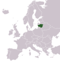 Location of Lithuania in Europe
 -
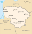 Map from CIA World Factbook
 -
 Physical map


Location of Cities - should NOT be used[edit]
The boundaries of counties in these maps are outdated. They changed in 2000. Updated maps are below (or browse category).
-
 Elektrenai in Lithuania
 -
 Klaipeda in Lithuania
 -
 Alytus in Lithuania
 -
 Druskininkai in Lithuania
 -
 Kalvarija in Lithuania
 -
 Kaunas in Lithuania
 -
 Marijampole in Lithuania
 -
 Palanga in Lithuania
 -
 Panevezys in Lithuania
 -
 Siauliai in Lithuania
 -
 Silute in Lithuania


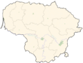
Locations of the cities - current[edit]
-
 Blank
Blank -
 Alytus
 -
 Anykščiai
 -
 Birštonas
 -
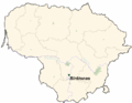
 Dieveniškės
 -
 Druskininkai
 -
 Elektrėnai
 -
 Jonava
 -
 Joniškis
 -
 Juknaičiai
 -
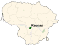 Kaunas
 -
 Kėdainiai
 -
 Klaipėda
 -
 Krekenava
 -
 Kurkliai
 -
 Marijampolė
 -
 Mažeikiai
 -
 Palanga
 -
 Panevėžys
 -
 Prienai
 -
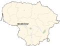
 Rokiškis
 -
 Rozalimas
 -
 Salantai
 -
 Saugos
 -
 Smalininkai
 -
 Šiauliai
 -
 Šilutė
 -
 Telšiai
 -
 Trakai
 -
 Ukmergė
 -
 Valkininkai
 -
 Varėna
 -
 Vievis
 -
 Vilnius


Location of Counties[edit]
-
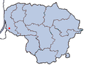
 All counties
 -
 Alytus County
 -
 Utena County
 -
 Šiauliai County
 -
 Panevėžys County
 -
 Telšiai County
 -
 Tauragė County
 -
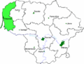 Klaipėda County
 -
 Marijampolė County
 -
 Kaunas County
 -
 Vilnius County


Historical maps[edit]
-
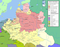
 Polish-Lithuanian Commonwealth in 17th and 18th century
 -
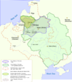
 Polish-Lithuanian Commonwealth - administrative division
 -
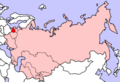 Location of Lithuanian SSR in the Soviet Union
 -
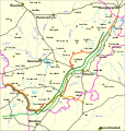 Line of Demarcation between Lithuania and Poland
 -
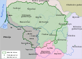
 Teritory of Lithuanian states during the history
 -
 Lithuania after 3rd partitions (1795)
 -
 Rusian empire parts in the current territory of Lithuania (1867-1915)
 -
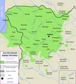 Lithuanian language in the 16th Century
 -
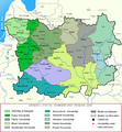 Lithuanian administrative divisions in the 17th c.
 -
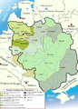 Lithuanian state expansion in the 13-15th c.


Satellite Photos[edit]
-
 Curonian Lagoon
 -
 Satellite image of Lithuania in March 2003

