Maps of Belgium
Jump to navigation
Jump to search
Countries of Europe: Albania · Andorra · Armenia‡ · Austria · Azerbaijan‡ · Belarus · Belgium · Bosnia and Herzegovina · Bulgaria · Croatia · Cyprus‡ · Czech Republic · Denmark · Estonia · Finland · France‡ · Georgia‡ · Germany · Greece · Hungary · Iceland · Republic of Ireland · Italy · Kazakhstan‡ · Latvia · Lithuania · Luxembourg · Malta · Monaco · Netherlands‡ · North Macedonia · Norway · Poland · Portugal‡ · Romania · Russia‡ · San Marino · Slovakia · Slovenia · Spain‡ · Sweden · Switzerland · Turkey‡ · Ukraine · United Kingdom · Vatican City
Specific status: Faroe Islands · Gibraltar · Isle of Man – Limited recognition: Abkhazia‡ · Kosovo
‡: partly located in Europe
Specific status: Faroe Islands · Gibraltar · Isle of Man – Limited recognition: Abkhazia‡ · Kosovo
‡: partly located in Europe
Belgium: België - Belgique - Belgien
- Maps are also available as part of the
 Wikimedia Atlas of the World project in the Atlas of Belgium.

- Belgium is a federal Kingdom in Europe
- België is een federaal koninkrijk in Europa
- La Belgique est un royaume fédéral d'Europe
- Belgien ist ein föderales Königreich in Europa
- Il Belgio è una monarchia federale in Europa
Geographical maps[edit]
-
 Location map for Belgium
 -
 Location map for Belgium in Europe
 -
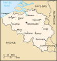
 Map of Belgium from CIA World Factbook
 -
 French version of the map
 -
 Esperanto version of the map
 -
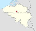
 Belgium, red spot for Liège
 -
 Belgium in french, red spot for Liège
 -
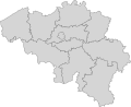
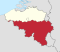
 Map of Belgian regions and provinces
 -
 Map of Belgian regions and provinces (French)
 -
 Map of Belgian regions and provinces (Spanish)
 -
 Vlaams Gewest (geel), Région Wallonne (rouge), Brussels Hoofdstedelijk Gewest (blauw)
 -
 Vlaamse Gemeenschap (geel), Communauté française de Belgique (rouge), Deutschsprachige Gemeinschaft Belgiens (blau)
 -
 Satellite image of Belgium in July 2001
 -
 Map of the frontier area between Begium and the Netherlands near Fort Eben-Emael
 -
 Les hautes fagnes in eastern belgium
 -
 Map of fortresses around Liege in Belgium
 -
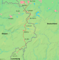 Map of the Venn railway between Belgium and Germany
 -
 Map of Belgium


Vlaanderen[edit]
-
 Vlaams Gewest
 -
 Provincies Vlaanderen


Provincie Antwerpen[edit]
-
 Provincie Antwerpen
 -
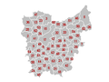
 Gemeenten van de provincie Antwerpen
_location.svg)

Provincie Limburg[edit]
-
 Provincie Limburg
 -
 Gemeenten van de provincie Limburg
_location.svg)

Provincie Oost-Vlaanderen[edit]
-
 Provincie Oost-Vlaanderen
 -
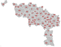
 Gemeenten van de provincie Oost-Vlaanderen
_location.svg)

Provincie Vlaams-Brabant[edit]
-
 Provincie Vlaams-Brabant
 -
 Gemeenten van de provincie Vlaams-Brabant
_location.svg)

Provincie West-Vlaanderen[edit]
-
 Provincie West-Vlaanderen
 -
 Gemeenten van de provincie West-Vlaanderen
_location.svg)

Région wallonne[edit]
-
 Région Wallone
 -
 Provinces de Wallonie


See also: Category:Wallonia
Province du Brabant Wallon[edit]
-
 Province du Brabant Wallon
 -
 Communes
_location.svg)

Maps of province of Brabant Wallon
Province de Hainaut[edit]
-
 Province de Hainaut
 -
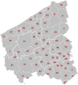
 Communes
_location.svg)

Province de Liège[edit]
-
 Province de Liège
 -
 Communes
_location.svg)

Province de Luxembourg[edit]
-
 Province de Luxembourg
 -
 Communes
_location.svg)

Maps of province of Luxembourg
Province de Namur[edit]
-
 Province de Namur
 -
 Communes
_location.svg)

Brussels Hoofdstedelijk Gewest - Région de Bruxelles-Capitale[edit]
w:nl:Brussels Hoofdstedelijk Gewest - w:fr:Région de Bruxelles-Capitale
-
 Région/Gewest
 -
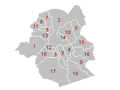 Gemeenten van het Gewest


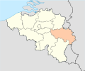
Deutschsprachige Gemeinschaft Belgiens[edit]
w:de:Deutschsprachige Gemeinschaft Belgiens
-
 Deutschsprachige Gemeinschaft
 -
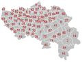
 Die 9 Gemeinden

