Mapes d'Andorra
(Redirected from Maps of Andorra)
Countries of Europe: Albania · Andorra · Armenia‡ · Austria · Azerbaijan‡ · Belarus · Belgium · Bosnia and Herzegovina · Bulgaria · Croatia · Cyprus‡ · Czech Republic · Denmark · Estonia · Finland · France‡ · Georgia‡ · Germany · Greece · Hungary · Iceland · Republic of Ireland · Italy · Kazakhstan‡ · Latvia · Lithuania · Luxembourg · Malta · Monaco · Netherlands‡ · North Macedonia · Norway · Poland · Portugal‡ · Romania · Russia‡ · San Marino · Slovakia · Slovenia · Spain‡ · Sweden · Switzerland · Turkey‡ · Ukraine · United Kingdom · Vatican City
Specific status: Faroe Islands · Gibraltar · Isle of Man – Limited recognition: Abkhazia‡ · Kosovo
‡: partly located in Europe
Specific status: Faroe Islands · Gibraltar · Isle of Man – Limited recognition: Abkhazia‡ · Kosovo
‡: partly located in Europe
- Maps are also available as part of the
 Wikimedia Atlas of the World project in the Atlas of Andorra.
Localització[edit]

From CIA World Factbook[edit]
-
 Map of Andorra in English
 -
 Map of Andorra translated to Spanish
 -
 Map of Andorra translated to French
 -
 Map of Andorra translated to Japanese


Parroquias / parishes[edit]
-
 Map of the parishes of Andorra.
 -
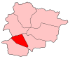 Andorra la Vella parish in Andorra
 -
 Canillo parish in Andorra
 -
 Encamp parish in Andorra
 -
 Escaldes-Engordany parish in Andorra
 -
 La Massana parish in Andorra
 -
 Ordino parish in Andorra
 -
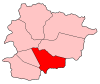
 Sant Julià de Lòria parish in Andorra


