Maps of the Netherlands
Jump to navigation
Jump to search
Countries of Europe: Albania · Andorra · Armenia‡ · Austria · Azerbaijan‡ · Belarus · Belgium · Bosnia and Herzegovina · Bulgaria · Croatia · Cyprus‡ · Czech Republic · Denmark · Estonia · Finland · France‡ · Georgia‡ · Germany · Greece · Hungary · Iceland · Republic of Ireland · Italy · Kazakhstan‡ · Latvia · Lithuania · Luxembourg · Malta · Monaco · Netherlands‡ · North Macedonia · Norway · Poland · Portugal‡ · Romania · Russia‡ · San Marino · Slovakia · Slovenia · Spain‡ · Sweden · Switzerland · Turkey‡ · Ukraine · United Kingdom · Vatican City
Specific status: Faroe Islands · Gibraltar · Isle of Man – Limited recognition: Abkhazia‡ · Kosovo
‡: partly located in Europe
Specific status: Faroe Islands · Gibraltar · Isle of Man – Limited recognition: Abkhazia‡ · Kosovo
‡: partly located in Europe
 |
- Maps are also available as part of the
 Wikimedia Atlas of the World project in the Atlas of the Netherlands.
Images showing locations of provincies in the Netherlands[edit]
 |
 |
 |
 |
 |
 |
 |
 |
 |
 |
 |
 |
 |
-
 Overview
 -
 Drenthe
 -
 Flevoland
 -
 Friesland
 -
 Gelderland
 -
 Groningen
 -
 Limburg
 -
 Noord-Brabant
 -
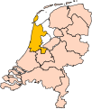 Noord-Holland
 -
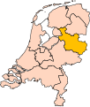 Overijssel
 -
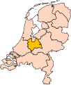 Utrecht
 -
 Zeeland
 -
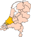 Zuid-Holland


Images showing locations of gemeentes in the Netherlands[edit]

Location of Rotterdam in the Netherlands
Gelderland[edit]
- Aalten
- Berkelland
- Bronckhorst
- Doetinchem
- Lochem
- Montferland
- Oost Gelre
- Oude IJsselstreek
- Zevenaar
- Zutphen