Maps of Finland
Jump to navigation
Jump to search
Countries of Europe: Albania · Andorra · Armenia‡ · Austria · Azerbaijan‡ · Belarus · Belgium · Bosnia and Herzegovina · Bulgaria · Croatia · Cyprus‡ · Czech Republic · Denmark · Estonia · Finland · France‡ · Georgia‡ · Germany · Greece · Hungary · Iceland · Republic of Ireland · Italy · Kazakhstan‡ · Latvia · Lithuania · Luxembourg · Malta · Monaco · Netherlands‡ · North Macedonia · Norway · Poland · Portugal‡ · Romania · Russia‡ · San Marino · Slovakia · Slovenia · Spain‡ · Sweden · Switzerland · Turkey‡ · Ukraine · United Kingdom · Vatican City
Specific status: Faroe Islands · Gibraltar · Isle of Man – Limited recognition: Abkhazia‡ · Kosovo
‡: partly located in Europe
Specific status: Faroe Islands · Gibraltar · Isle of Man – Limited recognition: Abkhazia‡ · Kosovo
‡: partly located in Europe
- Maps are also available as part of the
 Wikimedia Atlas of the World project in the Atlas of Finland.
-
 Location map for Finland
 -
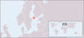
 Location map for Finland in Europe
 -
 Location map for Åland
 -
 CIA map of Finland
 -
 SVG map for locator use
 -
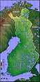 Topographic map
 -

-
 Demographic map


Satellite maps[edit]


Provinces of Finland[edit]
-
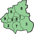
 Map of Finland with provinces
 -
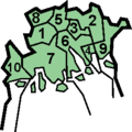
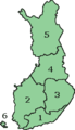 Map of Finland with provinces (numbered)
 -
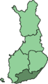
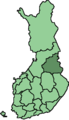
 Province of Eastern Finland (Itä-Suomen lääni)
 -
 Province of Lapland (Lapin lääni)
 -
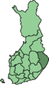
 Province of Oulu (Oulun lääni)
 -
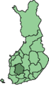
 Province of Southern Finland (Etelä-Suomen lääni)
 -
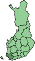
 Province of Western Finland (Länsi-Suomen lääni)
 -
 Province of Åland (Ahvenanmaan lääni)

.png)


Regions of Finland[edit]
-
 Blank map of regions (SVG)
 -
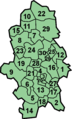
 Numbered locator map of regions (SVG)
 -
 Etelä-Karjala (South Karelia)
 -
 Etelä-Pohjanmaa (Southern Ostrobothnia)
 -
 Etelä-Savo (Southern Savonia)
 -
 Itä-Uusimaa (Eastern Uusimaa)
 -
 Kainuu
 -
 Kanta-Häme (Tavastia Proper)
 -
 Keski-Pohjanmaa (Central Ostrobothnia)
 -
 Keski-Suomi (Central Finland)
 -
 Kymenlaakso
 -
 Lappi (Lapland)
 -
 Pirkanmaa
 -
 Pohjanmaa (Ostrobothnia)
 -
 Pohjois-Karjala (North Karelia)
 -
 Pohjois-Pohjanmaa (Northern Ostrobothnia)
 -
 Pohjois-Savo (Northern Savonia)
 -
 Päijät-Häme (Päijänne Tavastia)
 -
 Satakunta
 -
 Uusimaa
 -
 Varsinais-Suomi (Finland Proper)
 -
 Åland (Ahvenanmaa)


Location of municipalities within the regions[edit]
-
 Municipalities of Åland (Ahvenanmaa)
 -
 Municipalities of Etelä-Karjala (South Karelia)
 -
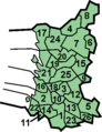
 Municipalities of Etelä-Pohjanmaa (Southern Ostrobothnia)
 -
 Municipalities of Etelä-Savo (Southern Savonia)
 -
 Municipalities of Itä-Uusima (East Uusimaa)
 -
 Municipalities of Kainuu
 -
 Municipalities of Kanta-Häme (Tavastia Proper)
 -
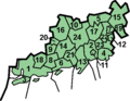
 Municipalities of Keski-Pohjanmaa (Central Ostrobothnia)
 -
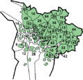
 Municipalities of Keski-Suomi (Central Finland)
 -
 Municipalities of Kymenlaakso
 -
 Municipalities of Lappi (Lapland)
 -
 Municipalities of Päijät-Häme
 -
 Municipalities of Pirkanmaa
 -
 Municipalities of Pohjanmaa (Ostrobothnia)
 -
 Municipalities of Pohjois-Karjala (North Karelia)
 -
 Municipalities of Pohjois-Pohjanmaa (Northern Ostrobothnia)
 -
 Municipalities of Pohjois-Savo (Northern Savonia)
 -
 Municipalities of Satakunta
 -
 Municipalities of Uusimaa
 -
 Municipalities of Varsinais-Suomi (Finland Proper)


Districts of Helsinki city[edit]
-
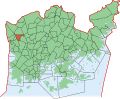
 All districts of Helsinki city
 -
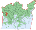
 District of Kannelmäki
 -
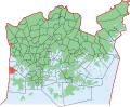
 District of Lassila
 -
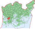
 District of Malminkartano
 -
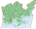
 District of Konala
 -
 District of Reimarla
 -
 District of Marttila
 -
 District of Pitäjänmäki
 -
 District of Pohjois-Haaga
 -
 District of Etelä-Haaga
 -
 District of Munkkivuori
 -
 District of Vanha Munkkiniemi
 -
 District of Kuusisaari
 -
 District of Lehtisaari
 -
 District of Lauttasaari
 -
 District of Kivihaka
 -
 District of Ruskeasuo
 -
 District of Meilahti
 -
 District of Laakso
 -
 District of Taka-Töölö
 -
 District of Etu-Töölö
 -
 District of Ruoholahti
 -
 District of Kruununhaka
 -
 District of Kluuvi


Historical maps[edit]
-
 Map of Mannerheim line, the main defense line along the Karelian Isthmus in Winter War.
 -
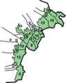
 Numbered Map of the historical provinces of Finland

