Maps of Norway
Jump to navigation
Jump to search
Countries of Europe: Albania · Andorra · Armenia‡ · Austria · Azerbaijan‡ · Belarus · Belgium · Bosnia and Herzegovina · Bulgaria · Croatia · Cyprus‡ · Czech Republic · Denmark · Estonia · Finland · France‡ · Georgia‡ · Germany · Greece · Hungary · Iceland · Republic of Ireland · Italy · Kazakhstan‡ · Latvia · Liechtenstein · Lithuania · Luxembourg · Malta · Moldova · Monaco · Montenegro · Netherlands‡ · North Macedonia · Norway · Poland · Portugal‡ · Romania · Russia‡ · San Marino · Serbia · Slovakia · Slovenia · Spain‡ · Sweden · Switzerland · Turkey‡ · Ukraine · United Kingdom · Vatican City
Specific status: Akrotiri and Dhekelia‡ · Faroe Islands · Gibraltar · Bailiwick of Guernsey · Isle of Man · Jersey · Svalbard – Limited recognition: Abkhazia‡ · Gagauzia · Kosovo · South Ossetia‡ · Transnistria · Northern Cyprus‡ · United Nations Buffer Zone in Cyprus‡
‡: partly located in Europe
Specific status: Akrotiri and Dhekelia‡ · Faroe Islands · Gibraltar · Bailiwick of Guernsey · Isle of Man · Jersey · Svalbard – Limited recognition: Abkhazia‡ · Gagauzia · Kosovo · South Ossetia‡ · Transnistria · Northern Cyprus‡ · United Nations Buffer Zone in Cyprus‡
‡: partly located in Europe
- Maps are also available as part of the
 Wikimedia Atlas of the World project in the Atlas of Norway.
-
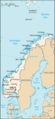
 Location map for Norway
 -
 Map of Norway with Svalbard and Bjørnøya
 -
 Map of the mainland of Norway
 -
 Map of the mainland of Norway with Norwegian caption
 -
 Satellite image of Norway in February 2003


Location maps[edit]
Location maps are available for all the counties (fylker) and some of the municipalities. They all have the same name syntax. Image:Name kart.png where name is the name of the place. Some of the filenames contain special characters, like æ, ø and å.
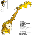
Maps of the counties (2017)[edit]
-
 SVG map based on the following two maps
 -
 Blank map
 -
 Location of Akershus
 -
 Location of Aust-Agder
 -
 Location of Buskerud
 -
 Location of Finnmark
 -
 Location of Hedmark
 -
 Location of Hordaland
 -
 Location of Møre og Romsdal
 -
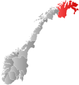
 Location of Nordland
 -
 Location of Nord-Trøndelag
 -
 Location of Oppland
 -
 Location of Oslo
 -
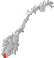
 Location of Rogaland
 -
 Location of Sogn og Fjordane
 -
 Location of Sør-Trøndelag
 -
 Location of Telemark
 -
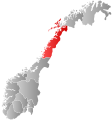
 Location of Troms
 -
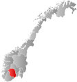
 Location of Vest-Agder
 -
 Location of Vestfold
 -
 Location of Østfold


