User talk:Don-kun
|
Unser Ratgeber Erste Schritte und unsere FAQ können Dir nach Deiner Anmeldung hilfreich sein. Sie erklären, wie Du die Benutzeroberfläche anpassen und zum Beispiel auf Deine Muttersprache umstellen kannst. Auch erklären sie, wie Du Dateien hochladen kannst. Daneben erläutern sie unsere grundlegende Lizenzpolitik. Du benötigst keine besonderen technischen Kenntnisse, um hier mitzumachen. Sei mutig hier beizutragen und gehe von den guten Absichten anderer aus. Dies ist ein Wiki - es ist wirklich einfach. Mehr Informationen bekommst Du im Gemeinschaftsportal. Du kannst Fragen im Forum oder im IRC-Chat #wikimedia-commons stellen, den du auch direkt hier öffnen kannst. Du kannst auch einen Administrator auf seiner Diskussionsseite ansprechen. Sofern Du eine spezielle Frage zum Urheberrecht hast, frage auf der Seite Diskussionsseite:Lizenzen. |
| |
| (P.S. Möchtest Du diese Nachricht kommentieren?) | ||
--Kimse (talk) 23:36, 4 August 2008 (UTC)
- THX. ^^ --Don-kun ( ) 10:05, 7 August 2008 (UTC)
Caucasus[edit]
I've seen your great maps and was inspired to try it by myself. Maybe you can take a look at File:Kaukasus 150n.svg (it's in German) and give me some advice. --Don-kun (talk) 16:27, 26 March 2009 (UTC)
- Hi Don-kun. Nice work ! I have not a lot of advice for you ; your map is already good. May be, about the font : you have used Arial and Times New Roman, but they are "obsolete" now (because they don't look in Commons like in Inkscape). We recommend to use DejaVu Sans Condensed and DejaVu Serif Condensed instead.
- To do maps, we (the "we" is the Atelier graphique, the french Kartenwerkstatt) use some tutorials and a set (in french).
- Last thing, the habit is to name a map in english, and end by a language code suffix. Example : Caucasus 150 map-de.svg.
- Sémhur (talk) 09:00, 28 March 2009 (UTC)
Kaukasus-Karten[edit]
Hallo Don-kun,
du hattest diese und diese Karte für die Schnelllöschung vorgeschlagen. Kannst du mir nur kurz die Links für die ersetzen Versionen geben, falls es welche gibt? Falls nein, könntest du die Karten einfach korrigieren anstatt sie schnelllöschen zu lassen? Ein etwas konfuser --Jcornelius (talk) 19:34, 3 May 2009 (UTC)
- Nein, es gibt weder neue Versionen noch korrigierte. Ich weiß einfach nicht, wie es zu dieser Zeit wirklich aussah, die Karte die ich als Grundlage genommen habe widerspricht dem Buch über Georgien, das ich habe. Ich kann also ziemlich sicher sagen, dass die Karte falsch ist (was mir leider zu spät auffiel), aber eine bessere Version habe ich nicht. Sie sollte aber auch nciht verwendet werden, daher löschen. Grüße --Don-kun (talk) 19:40, 3 May 2009 (UTC)
Tip: Categorizing images[edit]

Thanks a lot for contributing to the Wikimedia Commons! Here's a tip to make your uploads more useful: Why not add some categories to describe them? This will help more people to find and use them.
Here's how:
1) If you're using the UploadWizard, you can add categories to each file when you describe it. Just click "more options" for the file and add the categories which make sense:

2) You can also pick the file from your list of uploads, edit the file description page, and manually add the category code at the end of the page.
[[Category:Category name]]
For example, if you are uploading a diagram showing the orbits of comets, you add the following code:
[[Category:Astronomical diagrams]][[Category:Comets]]
This will make the diagram show up in the categories "Astronomical diagrams" and "Comets".
When picking categories, try to choose a specific category ("Astronomical diagrams") over a generic one ("Illustrations").
Thanks again for your uploads! More information about categorization can be found in Commons:Categories, and don't hesitate to leave a note on the help desk.BotMultichillT 05:46, 4 May 2009 (UTC)
- Image:Shanghai Yuyuan 2006 3.JPG is uncategorized since 3 May 2009.
- Image:Shanghai Yuyuan 2006 2.JPG is uncategorized since 3 May 2009.
- Image:Shanghai panorama.JPG is uncategorized since 3 May 2009.
- Image:Xian wall 2006 2.JPG is uncategorized since 3 May 2009.
- Image:Xian wall 2006.JPG is uncategorized since 3 May 2009.
- Image:MalaysiaThai.svg was uncategorized on 22 December 2009 CategorizationBot (talk) 10:40, 23 December 2009 (UTC)
- Image:South east asia topographic map.svg was uncategorized on 6 March 2010 CategorizationBot (talk) 10:39, 7 March 2010 (UTC)
- Image:Veilchenweg 2011-11 012.jpg was uncategorized on 22 November 2011 CategorizationBot (talk) 11:38, 23 November 2011 (UTC)
- Image:Veilchenweg 2011-11 037.jpg was uncategorized on 22 November 2011 CategorizationBot (talk) 11:38, 23 November 2011 (UTC)
- Image:Veilchenweg 2011-11 018.jpg was uncategorized on 22 November 2011 CategorizationBot (talk) 11:38, 23 November 2011 (UTC)
- Image:Veilchenweg 2011-11 021.jpg was uncategorized on 22 November 2011 CategorizationBot (talk) 11:38, 23 November 2011 (UTC)
- Image:Veilchenweg 2011-11 030.jpg was uncategorized on 22 November 2011 CategorizationBot (talk) 11:38, 23 November 2011 (UTC)
- Image:Veilchenweg 2011-11 026.jpg was uncategorized on 22 November 2011 CategorizationBot (talk) 11:38, 23 November 2011 (UTC)
- Image:Veilchenweg 2011-11 016.jpg was uncategorized on 22 November 2011 CategorizationBot (talk) 11:38, 23 November 2011 (UTC)
- Image:Veilchenweg 2011-11 033.jpg was uncategorized on 22 November 2011 CategorizationBot (talk) 11:38, 23 November 2011 (UTC)
- Image:Veilchenweg 2011-11 010.jpg was uncategorized on 22 November 2011 CategorizationBot (talk) 11:38, 23 November 2011 (UTC)
- Image:Veilchenweg 2011-11 002.jpg was uncategorized on 22 November 2011 CategorizationBot (talk) 11:38, 23 November 2011 (UTC)
- Image:Veilchenweg 2011-11 043.jpg was uncategorized on 22 November 2011 CategorizationBot (talk) 11:38, 23 November 2011 (UTC)
- Image:Veilchenweg 2011-11 022.jpg was uncategorized on 22 November 2011 CategorizationBot (talk) 11:38, 23 November 2011 (UTC)
- Image:Veilchenweg 2011-11 045.jpg was uncategorized on 22 November 2011 CategorizationBot (talk) 11:38, 23 November 2011 (UTC)
- Image:Veilchenweg 2011-11 046.jpg was uncategorized on 22 November 2011 CategorizationBot (talk) 11:38, 23 November 2011 (UTC)
- Image:Veilchenweg 2011-11 029.jpg was uncategorized on 22 November 2011 CategorizationBot (talk) 11:38, 23 November 2011 (UTC)
- Image:Veilchenweg 2011-11 004.jpg was uncategorized on 22 November 2011 CategorizationBot (talk) 11:38, 23 November 2011 (UTC)
- Image:Veilchenweg 2011-11 034.jpg was uncategorized on 22 November 2011 CategorizationBot (talk) 11:38, 23 November 2011 (UTC)
- Image:Veilchenweg 2011-11 048.jpg was uncategorized on 22 November 2011 CategorizationBot (talk) 11:38, 23 November 2011 (UTC)
- Image:Veilchenweg 2011-11 032.jpg was uncategorized on 22 November 2011 CategorizationBot (talk) 11:38, 23 November 2011 (UTC)
- Image:Veilchenweg 2011-11 014.jpg was uncategorized on 22 November 2011 CategorizationBot (talk) 11:38, 23 November 2011 (UTC)
- Image:Veilchenweg 2011-11 001.jpg was uncategorized on 22 November 2011 CategorizationBot (talk) 11:38, 23 November 2011 (UTC)
- Image:Veilchenweg 2011-11 028.jpg was uncategorized on 22 November 2011 CategorizationBot (talk) 11:38, 23 November 2011 (UTC)
- Image:Veilchenweg 2011-11 041.jpg was uncategorized on 22 November 2011 CategorizationBot (talk) 11:38, 23 November 2011 (UTC)
- Image:Veilchenweg 2011-11 020.jpg was uncategorized on 22 November 2011 CategorizationBot (talk) 11:38, 23 November 2011 (UTC)
- Image:Veilchenweg 2011-11 047.jpg was uncategorized on 22 November 2011 CategorizationBot (talk) 11:38, 23 November 2011 (UTC)
- Image:Veilchenweg 2011-11 015.jpg was uncategorized on 22 November 2011 CategorizationBot (talk) 11:38, 23 November 2011 (UTC)
- Image:Veilchenweg 2011-11 039.jpg was uncategorized on 22 November 2011 CategorizationBot (talk) 11:38, 23 November 2011 (UTC)
- Image:Veilchenweg 2011-11 036.jpg was uncategorized on 22 November 2011 CategorizationBot (talk) 11:38, 23 November 2011 (UTC)
- Image:Veilchenweg 2011-11 027.jpg was uncategorized on 22 November 2011 CategorizationBot (talk) 11:38, 23 November 2011 (UTC)
- Image:Veilchenweg 2011-11 042.jpg was uncategorized on 22 November 2011 CategorizationBot (talk) 11:38, 23 November 2011 (UTC)
- Image:Veilchenweg 2011-11 031.jpg was uncategorized on 22 November 2011 CategorizationBot (talk) 11:38, 23 November 2011 (UTC)
- Image:Veilchenweg 2011-11 049.jpg was uncategorized on 22 November 2011 CategorizationBot (talk) 11:38, 23 November 2011 (UTC)
- Image:Veilchenweg 2011-11 024.jpg was uncategorized on 22 November 2011 CategorizationBot (talk) 11:38, 23 November 2011 (UTC)
- Image:Veilchenweg 2011-11 003.jpg was uncategorized on 22 November 2011 CategorizationBot (talk) 11:38, 23 November 2011 (UTC)
- Image:Veilchenweg 2011-11 013.jpg was uncategorized on 22 November 2011 CategorizationBot (talk) 11:38, 23 November 2011 (UTC)
- Image:Veilchenweg 2011-11 011.jpg was uncategorized on 22 November 2011 CategorizationBot (talk) 11:38, 23 November 2011 (UTC)
- Image:Veilchenweg 2011-11 035.jpg was uncategorized on 22 November 2011 CategorizationBot (talk) 11:38, 23 November 2011 (UTC)
- Image:Veilchenweg 2011-11 044.jpg was uncategorized on 22 November 2011 CategorizationBot (talk) 11:38, 23 November 2011 (UTC)
- Image:Veilchenweg 2011-11 019.jpg was uncategorized on 22 November 2011 CategorizationBot (talk) 11:38, 23 November 2011 (UTC)
- Image:Veilchenweg 2011-11 017.jpg was uncategorized on 22 November 2011 CategorizationBot (talk) 11:38, 23 November 2011 (UTC)
- Image:Veilchenweg 2011-11 038.jpg was uncategorized on 22 November 2011 CategorizationBot (talk) 11:38, 23 November 2011 (UTC)
- Image:Veilchenweg 2011-11 023.jpg was uncategorized on 22 November 2011 CategorizationBot (talk) 11:38, 23 November 2011 (UTC)
- Image:Veilchenweg 2011-11 040.jpg was uncategorized on 22 November 2011 CategorizationBot (talk) 11:38, 23 November 2011 (UTC)
- Image:Veilchenweg 2011-11 025.jpg was uncategorized on 22 November 2011 CategorizationBot (talk) 11:38, 23 November 2011 (UTC)
Pulko[edit]
you can erase it no problem!! --PulkoCitron (talk) 13:17, 7 May 2009 (UTC)
Was ever an permission email sent to OTRS? If yes, could you please ask an OTRS volunteer what's happening. --Túrelio (talk) 18:55, 3 June 2009 (UTC)
- I asked one. There seems to be a problem and he send a Mail to the artist but didnt got a response until now. I'll try to fix it :) --Don-kun (talk) 19:09, 3 June 2009 (UTC)
- Oh, this may be a misunderstanding. It's your job as uploader to prepare a permission email and ask the rights holder to sent it to OTRS. Thereafter someone from the OTRS team puts the OTRS ticket on the image. You'll find templates in different languages here: Commons:Email templates. --Túrelio (talk) 19:16, 3 June 2009 (UTC)
- Yes, the artist send a mail to the OTRS-Team, but there was a problem (which I don't know), so the OTRS volunteer send a mail to the artist, but got no answer. --Don-kun (talk) 20:20, 3 June 2009 (UTC)
- Oh, this may be a misunderstanding. It's your job as uploader to prepare a permission email and ask the rights holder to sent it to OTRS. Thereafter someone from the OTRS team puts the OTRS ticket on the image. You'll find templates in different languages here: Commons:Email templates. --Túrelio (talk) 19:16, 3 June 2009 (UTC)

|
File:Engel_mit_Teddy.jpeg has been listed at Commons:Deletion requests so that the community can discuss whether it should be kept or not. We would appreciate it if you could go to voice your opinion about this at its entry.
If you created this file, please note that the fact that it has been proposed for deletion does not necessarily mean that we do not value your kind contribution. It simply means that one person believes that there is some specific problem with it, such as a copyright issue. Please see Commons:But it's my own work! for a guide on how to address these issues. |
Yann (talk) 19:24, 3 June 2009 (UTC)
 |
File:Salatin Askerova.jpg has been marked as a possible copyright violation. Wikimedia Commons only accepts free content—that is, images and other media files that can be used by anyone, for any purpose. Traditional copyright law does not grant these freedoms, and unless noted otherwise, everything you find on the web is copyrighted and not permitted here. For details on what is acceptable, please read Commons:Licensing. You may also find Commons:Copyright rules useful, or you can ask questions about Commons policies at the Commons:Help desk. If you are the copyright holder and the creator of the file, please read Commons:But it's my own work! for tips on how to provide evidence of that.
The file you added has been deleted. If you have written permission from the copyright holder, please have them send us a free license release via COM:VRT. If you believe that the deletion was not in accordance with policy, you may request undeletion. (It is not necessary to request undeletion if using VRT; the file will be automatically restored at the conclusion of the process.) Warning: Wikimedia Commons takes copyright violations very seriously and persistent violators will be blocked from editing.
|
The same with the other photos of Azerbaijanis from WWII. --Don-kun (talk) 09:19, 5 June 2009 (UTC)
Hallo, Don-kun. Die "scannered" Bilde habe ich selbst gemacht. Aber die Bilde, mit denen ich die Quelle gegeben habe, sind frei to Copyright.--Interfase (talk) 10:28, 5 June 2009 (UTC)
- Selbstgemacht ist es aber nicht, wenn du es selbst gescannt hast. Du musst der Fotograf der Bilder sein, um die Urheberrechte zu haben. Und das bist du wohl kaum, wenn die Bilder 60 Jahre alt sind. Wenn das Copyright abgelaufen ist (hängt von der Rechtslage in dem Land ab), muss ein entsprechender Baustein drunter und keine GNU-Lizenz, denn die behauptet ja die Existenz eines Copyrights. Kläre am besten nochmal ab, ob das Urheberrecht wirklich abgelaufen ist. --Don-kun (talk) 10:35, 5 June 2009 (UTC)
File:Commons-tan Wikipe-tan Wikiquote-tan.jpeg may be deleted[edit]
The File:Commons-tan Wikipe-tan Wikiquote-tan.jpeg which you uploaded has been tagged {{OTRS pending}} for more than 30 days. This tag indicates that an email setting out permission to use the file was sent to the OTRS team. Unfortunately, we cannot find any record that such an email has been received, and accordingly the file remains without permission. Unless the OTRS team receives evidence that permission has been granted within 15 days of today's date, the file will be deleted. If you have already sent the permission, please re-send it to "permissions-commons![]() wikimedia.org" now. At the same time, please leave a message at the OTRS noticeboard so that a volunteer can follow this up. Alternatively, you can contact an OTRS volunteer directly. HersfoldOTRSBot(talk) 21:17, 7 June 2009 (UTC)
wikimedia.org" now. At the same time, please leave a message at the OTRS noticeboard so that a volunteer can follow this up. Alternatively, you can contact an OTRS volunteer directly. HersfoldOTRSBot(talk) 21:17, 7 June 2009 (UTC)
File:Uniform Asuka.JPG may be deleted[edit]
|
| |
Uniform Asuka.JPG which you uploaded has been tagged with {{OTRS pending}} for more than 30 days. This tag indicates that an email setting out permission to use the file was sent to the Volunteer Response Team. Unfortunately, we cannot find any record that such an email has been received, and accordingly the file remains without permission. Unless the Volunteer Response Team receives evidence that permission has been granted within 15 days of today's date, the file will be deleted. If you have already sent the permission, please re-send it to permissions-commons@wikimedia.org now. Please quote the file name ("Uniform Asuka.JPG") in your email. At the same time, please leave a message at the VRT noticeboard so that a volunteer can follow this up or contact a VRT member directly.
| |
HersfoldOTRSBot(talk) 23:30, 8 June 2009 (UTC)
Miyazaki-like illustrations[edit]
Hi,
I noticed your copyvio taggings on File:Hommage à Miyazaki - Mon voisin Totoro.jpg and the two others.
The thing is, those files are not fan-arts ; it seems they are authorised derivative works, as they illustrate an official book on Miyazaki art published in France. The artist was convinced by a fellow fr.wp editor to release those pictures under a free license (he is the uploader, though he has not sent a permission by OTRS yet ; he shall do it soon enough).
Though, I do not know if it is okay ; maybe you are right and those are copyvios. I cannot tell. Maybe it would be better to open a deletion request ?
Cheers, Jean-Fred (talk) 11:04, 6 August 2009 (UTC)
- Well, the characters are copyrighted by their creator (Ghibli/Miyazaki/don't know). So the artist may be allowed to draw them, but he also needs a permission from the copyright holder to release them under a free licence. That he has the right to draw the pictures and to publish them in a book doesn't mean that he has the right to publish pictures of the characters under a free licence. --Don-kun (talk) 13:48, 6 August 2009 (UTC)
- I agree on every point. But maybe he does have permission? I also doubt it, but well, maybe. Okki has made contact with him, wait and see. Jean-Fred (talk) 15:20, 6 August 2009 (UTC)
- If he has the permission, he has to proove it. --Don-kun (talk) 08:02, 7 August 2009 (UTC)
- I agree on every point. But maybe he does have permission? I also doubt it, but well, maybe. Okki has made contact with him, wait and see. Jean-Fred (talk) 15:20, 6 August 2009 (UTC)
Map of Alania[edit]
What you mean "it's difficult to find some reliable sources in this area"? As you can see, my map of Alania is based on history atlas whose author is a doctor of historical sciences from Russia: http://commons.wikimedia.org/wiki/File:Alania_10_12.png#Sources I also do not think that it is our job to decide "which map may be right" but to present all opinions about the subject. I presented the opinion of one Russian historian in my map and that have nothing to do with opinion of Georgian historians which also should be presented. I am against any kind of censorship in this area and, as I said, it is not up to us to decide which opinion is valid and which is not. PANONIAN (talk) 07:50, 7 August 2009 (UTC)
- Thats right. I meant that we should look if the opinions may match together. For example does the map from the atlas show Alania from 10. - 12. century, or does it show one state of Alania in these three centuries. If that is the case, it does not need to be an antithesis to the other maps. --Don-kun (talk) 08:01, 7 August 2009 (UTC)
- Or more directly: Does the original map (I cant't read it, because I can't read Russia) claim to show the expansion of Alania during the hole three centuries, or does it only claim to show one of the expansions Alania occupied during that three centuries (maybe the largest). --Don-kun (talk) 08:07, 7 August 2009 (UTC)
- Well, good point. The opinions can always match together (I know that from views about Serbian-Albanian relations in history). As for original map in Russian, it has this description: "Alania from 7th to 12th century" (that is title of the whole map). As for territory on the map that represent Alania, it has this description: "Territory of Alanian state, according to historical and archaeological documents", so it does not specify which century exactly it represent. But, there are another descriptions on the map that mention locations of "christian temples from 10th-12th century" and "Khazarian khanate from 11th century". However, I read some of the history text from this page: http://iratta.com/2007/03/03/alanija_v_viixii_vv.html - the text say that Christianity came to Alania in the 10th century and that in 10th-11th century Christian temples were built in Alania, and according to this map such temples were located in South Ossetia as well, which means that it would be correct to say that map represent Alanian borders in the 10th century: http://iratta.com/uploads/posts/atlas/09/karta.jpg However, there is another map that represent Alania in the 13th-14th century (after Turkic tribes invaded its northern part) and on this map South Ossetia is still part of Alania: http://iratta.com/2007/03/04/alanija_v_xiiixiv_vv.html - the description for the territory on the map is following: "territory of independent upper Alania". In another words, my map would still represent Alania between 10th and 12th century, i.e. after Christianity came to Alania in the 10th century and before Turkic tribes invaded Alania in the 12th-13th century. However, as you can see on my map, when I compared borders of Alania and modern South Ossetia, the result was that parts of modern South Ossetia (including South Ossetian capital Tskhinvali) were ruled by Georgia: http://commons.wikimedia.org/wiki/File:Alania_10_12.png - so that might be possible common ground of Alanian and Georgian historical views - part of South Ossetia belonged to Alania and another part to Georgia. PANONIAN (talk) 09:33, 7 August 2009 (UTC)
- And interestingly, Euratlas does not show that Georgia ruled South Ossetia in this time, see: http://www.euratlas.com/history_europe/europe_map_1000.html and: http://www.euratlas.com/history_europe/europe_map_1100.html PANONIAN (talk) 09:42, 7 August 2009 (UTC)
- Of course, there is always possible explanation that borders often changed during this time, so that parts of South Ossetia in question were in some parts of this time period controled by Alania and in some parts by Georgia and that historians from both countries represent only those parts of this history period when their country was larger. PANONIAN (talk) 09:56, 7 August 2009 (UTC)
- And interestingly, Euratlas does not show that Georgia ruled South Ossetia in this time, see: http://www.euratlas.com/history_europe/europe_map_1000.html and: http://www.euratlas.com/history_europe/europe_map_1100.html PANONIAN (talk) 09:42, 7 August 2009 (UTC)
- Well, good point. The opinions can always match together (I know that from views about Serbian-Albanian relations in history). As for original map in Russian, it has this description: "Alania from 7th to 12th century" (that is title of the whole map). As for territory on the map that represent Alania, it has this description: "Territory of Alanian state, according to historical and archaeological documents", so it does not specify which century exactly it represent. But, there are another descriptions on the map that mention locations of "christian temples from 10th-12th century" and "Khazarian khanate from 11th century". However, I read some of the history text from this page: http://iratta.com/2007/03/03/alanija_v_viixii_vv.html - the text say that Christianity came to Alania in the 10th century and that in 10th-11th century Christian temples were built in Alania, and according to this map such temples were located in South Ossetia as well, which means that it would be correct to say that map represent Alanian borders in the 10th century: http://iratta.com/uploads/posts/atlas/09/karta.jpg However, there is another map that represent Alania in the 13th-14th century (after Turkic tribes invaded its northern part) and on this map South Ossetia is still part of Alania: http://iratta.com/2007/03/04/alanija_v_xiiixiv_vv.html - the description for the territory on the map is following: "territory of independent upper Alania". In another words, my map would still represent Alania between 10th and 12th century, i.e. after Christianity came to Alania in the 10th century and before Turkic tribes invaded Alania in the 12th-13th century. However, as you can see on my map, when I compared borders of Alania and modern South Ossetia, the result was that parts of modern South Ossetia (including South Ossetian capital Tskhinvali) were ruled by Georgia: http://commons.wikimedia.org/wiki/File:Alania_10_12.png - so that might be possible common ground of Alanian and Georgian historical views - part of South Ossetia belonged to Alania and another part to Georgia. PANONIAN (talk) 09:33, 7 August 2009 (UTC)
- Well, the first thing I wonder about in these maps is that Abkhazia is there. But Abkhazia was part of the Georgian Kingdom after 1001 (or earlier, depends on the definition, it was ruled by a Bagrationi since 978). So thats kind a strange part of all these maps and a matter for me to ask, if they may only state the situation before 978 or before 1001.
- The second is, that I won't rely on the maps from Euroatlas. They seem to be too unsure to clear the belonging of south Ossetia in that time. And were there Khazars after the 10th century? I thought Pechenegs invaded the area in that time and Khazars didn't play such a role after that.
- Third thing are my sources. The maps from Andrew Andersen (problem is, I don't realy know who he is) like these two http://commons.wikimedia.org/wiki/File:Georgia_map_830-1020.gif http://commons.wikimedia.org/wiki/File:Geor_david.gif ; an a book from the German de:Heinz Fähnrich. He mentions wars in Inner Kartli only before 978, and no after that. So it seems, that south Ossetia was part of Georgian states until then. Late he mentions the conquest of the en:Darial Gorge by Dawit IV. (1089-1125) and that since him until the mongol invasion the countries north of the Caucasus (including Alania) were Georgian vasalls. --Don-kun (talk) 11:03, 7 August 2009 (UTC)
- He may be User:Andrew Andersen. --Don-kun (talk) 11:08, 7 August 2009 (UTC)
- Sorry to answering you now, but I was bussy with other things. I am not quite an expert for Caucasian history, and my map might not be 100% correct since it is based on Russian source only, but I hope that it will not be deleted on the basis that it is based on a source that is legitimate for usage in Wikimedia (author of original Russian map is an doctor of historical sciences) and on the basis that my source is not an extremist or chauvinist web site or media, whose content would not be appropriate for usage here. In another words, this map could reamain here as a representation of view of Russian/Ossetian historians about the subject and the question in which Wikipedia articles this map will be used is another subject since Wikimedia Commons is here only too keep media files and nothing more. Regarding some of the sources that you mentioned, the fact that Andrew Andersen has his own web site does not mean that his maps are more accurate than mine, especially because he did not elaborated sources for each of his maps (while I did elaborated sources for most of my maps, and I will try to elaborate sources for all of them when I find time). My mistake was that I did not elaborated source for this map of Alania, so it was in fact proposed for deletion on the basis that it is unsourced (and it was indeed until I provided description of my source). In the future, I will try not to make such mistakes. PANONIAN (talk) 16:28, 11 August 2009 (UTC)
- I totally agree with you. And I only linked the page of Andersen because I think its important to know who he is if we use his maps. And in Detail his maps and the statements of Fähnrich doesn't match in every point. So I will correct my maps too (thats easy, they're Vectormaps ;) and I will look for some more opinions. armenica.org (who may not be neutral too) have also many maps and they name some sources. --Don-kun (talk) 17:24, 11 August 2009 (UTC)
- Sorry to answering you now, but I was bussy with other things. I am not quite an expert for Caucasian history, and my map might not be 100% correct since it is based on Russian source only, but I hope that it will not be deleted on the basis that it is based on a source that is legitimate for usage in Wikimedia (author of original Russian map is an doctor of historical sciences) and on the basis that my source is not an extremist or chauvinist web site or media, whose content would not be appropriate for usage here. In another words, this map could reamain here as a representation of view of Russian/Ossetian historians about the subject and the question in which Wikipedia articles this map will be used is another subject since Wikimedia Commons is here only too keep media files and nothing more. Regarding some of the sources that you mentioned, the fact that Andrew Andersen has his own web site does not mean that his maps are more accurate than mine, especially because he did not elaborated sources for each of his maps (while I did elaborated sources for most of my maps, and I will try to elaborate sources for all of them when I find time). My mistake was that I did not elaborated source for this map of Alania, so it was in fact proposed for deletion on the basis that it is unsourced (and it was indeed until I provided description of my source). In the future, I will try not to make such mistakes. PANONIAN (talk) 16:28, 11 August 2009 (UTC)
- He may be User:Andrew Andersen. --Don-kun (talk) 11:08, 7 August 2009 (UTC)
Die Karte des Kaukasus[edit]
Könntest du mir sagen,welche Quelle du benutzt hast,um diese Karte zu erstellen:
http://upload.wikimedia.org/wikipedia/commons/8/8e/Caucasus_750n_de.png --იბერია (talk) 14:43, 8 August 2009 (UTC)
- Für das was dich interessiert den Fähnrich. Während der Herrschaft der Perser und auch später der Araber kamen Chasaren und Alanen über den Kaukasus. --Don-kun (talk) 15:27, 8 August 2009 (UTC)
Jamal Rahimov[edit]
Hallo. Sehen Sie bitte diese Bild. Habe ich alles richtig gemacht? --Interfase (talk) 15:26, 19 February 2010 (UTC)
- Das Bild darf hier nicht hochgeladen werden. Die Lizenz (CC-by-sa-nc) ist hier nicht zulässig. --Don-kun (talk) 15:34, 19 February 2010 (UTC)
Topographic maps[edit]
Hello! I used your map of the caucasus to create maps like this one. Now I am asked to make such maps about Siam, but I cannot find a topographic map I could use. Can you make a topographic map of south-east Asia, that I can use then? From Kunming in the north to Sumatra would be enought, maybe Borneo an Java too. Greetings --Don-kun (talk) 18:41, 18 February 2010 (UTC)
- Hello, not right now, but another time I will think about it. You may also do a request at Kartenwerkstatt. Bis bald ! Bourrichon (talk) 14:05, 23 February 2010 (UTC)
http://commons.wikimedia.org/wiki/File:Animacion-com-plastilina-y-clay-animation-pelicula-Kuzmich-153.jpg[edit]
Hello! I do not understand what the problem with my file http://commons.wikimedia.org/wiki/File:Animacion-com-plastilina-y-clay-animation-pelicula-Kuzmich-153.jpg
Explain please! I'm a new user in Wikipedia and do not understand all the legal nuances. There are doubts in my authorship of this file? or doubt that I convey the right for general use? What should I do in this situation?
Maps of Caucasus[edit]
Hi. You made very good work with historical maps of Caucasus. Can you also create some historical maps related to more recent history, let say 16th-18th century, i.e. time of Persian and Ottoman rule in Caucasus? I think that this time period is not present enough in history maps related to the Caucasus. PANONIAN (talk) 23:48, 5 April 2010 (UTC)
- I want to make more maps of the Caucasus, about 2 maps per century, and so I will come to 16th-18th century anytime (but Georgia under Tamar and under Mongols would be first). But now I make some maps of South-East-Asia, so it will take some time until I'll be back to the Caucasus ;) --Don-kun (talk) 08:16, 6 April 2010 (UTC)
- Ok, take your time. It is just that I am interested in 16th-18th century maps of Caucasus and I cannot find anywhere good and detailed maps of that time period (althought, I haw some not very detailed from The Times History of Europe). I suppose I have to wait until you made them. :) PANONIAN (talk) 21:33, 6 April 2010 (UTC)
Georgian Church[edit]
Hi, sorry to disturb, but are you sure this is a photo of a Tbilisi church? :)--Gaeser (talk) 07:24, 8 April 2010 (UTC)
- No. In Tbilisi, Telavi or near one of these cities. --Don-kun (talk) 12:11, 9 April 2010 (UTC)
Raruto, is not Naruto. They are different series.[edit]

Raruto, is not Naruto. They are different series; differents drawings made by different authors. That's because there are not problems with copyright. Thank you, and regards from Spain.
- Its obviously a derivated series, so the permission from the copyright holder of Naruto is needed. --Don-kun (talk) 13:14, 10 June 2010 (UTC)
Date-Parameter[edit]
Da kommt das Aufnahmedatum (wenigstens ein ungefähres) rein, nicht das Hochladedatum. --91.64.58.117 10:17, 30 June 2010 (UTC)
- Datum der Aufnahme oder Veröffentlichung. Und die Veröffentlichung war an diesem Datum. Ein Aufnahmedatum ist nicht bekannt, auch nicht ungefähr. --Don-kun (talk) 10:33, 30 June 2010 (UTC)
David IV map[edit]
Hi! File:David IV map de.png <--- this is a great picture, i'll translate it into Georgian, but picture is so fantastic! Georgian wikipedia will have 2 pictures from you my friend =))) Thanks a lott--თეკა (talk) 19:57, 6 October 2010 (UTC)
Dias aus Mecklenburg[edit]
Hallo Don-kun, ich habe hier mal etwas nachgebessert. Falls es dir nicht gefällt, bitte zurücksetzen! Zu allen Bildern wurde hier gerade dazu aufgerufen, mitzusuchen und zu kategorisieren. Zwei Bilder sind seitenverkehrt - oder alle? Vielleicht kannst du helfen. (Oder deine Oma;) Gruß. --Schiwago (talk) 11:35, 8 October 2010 (UTC)
- PS: Quatsch, alle nicht, die Beschriftung auf der Lok ist ja OK. --Schiwago (talk) 11:36, 8 October 2010 (UTC)
- Danke für die Bilder. Falls du noch weitere findest, kannst du uns ja gerne auf der Portaldisk anschreiben. Vielleicht können wir helfen. Viele Grüße -- Niteshift (talk) 11:56, 8 October 2010 (UTC)
- Nein, mehr gibts nicht. Aber schaut doch mal bei User:Don-kun/gallery DDR rein, vielleicht könnt ihr da noch mehr zuordnen. --Don-kun (talk) 18:10, 8 October 2010 (UTC)
- Ah, wie ich sehe habt ihr die Gallerie schon gefunden :) --Don-kun (talk) 18:16, 8 October 2010 (UTC)
- Nein, mehr gibts nicht. Aber schaut doch mal bei User:Don-kun/gallery DDR rein, vielleicht könnt ihr da noch mehr zuordnen. --Don-kun (talk) 18:10, 8 October 2010 (UTC)
- Danke für die Bilder. Falls du noch weitere findest, kannst du uns ja gerne auf der Portaldisk anschreiben. Vielleicht können wir helfen. Viele Grüße -- Niteshift (talk) 11:56, 8 October 2010 (UTC)
Fotos of your mother[edit]
Hi, could your mother send an e-mail to OTRS. That would protect here, but also Commons. Those pictures are very valuable. I think here is an information in German: w:de:Wikipedia:Support-Team.--Juan de Vojníkov (talk) 21:59, 21 October 2010 (UTC)
- Of course not, my Grandmother does not have an Email-Account. But a Commons admin (namely 32x) said, that would be OK. --Don-kun (talk) 04:13, 22 October 2010 (UTC)
I see, your grandmother. I am sorry. Well its up your grandmother, not the Commons admin of course. So if you thing so, why not. Possibility could be a letter to Wikimedia Deuchland. But well, thank you very much and your grandmom too for such pictures.--Juan de Vojníkov (talk) 05:43, 22 October 2010 (UTC)
- I asked some people who contributed many pictures on Commons before, among them one admin, and we all thought that a letter or something like that would be too extensive, especially as in that case I am the heir to the copyrights (not the only, but there are not many). --Don-kun (talk) 08:30, 22 October 2010 (UTC)
HI, tell me please what a city on the photo? --фрашкард (talk) 07:38, 4 November 2010 (UTC)
and File:Aserbaidschan 1987 001.jpg.--фрашкард (talk) 07:40, 4 November 2010 (UTC)
- I don't know. --Don-kun (talk) 10:08, 4 November 2010 (UTC)
:File:Dresden_Hbf0005.tif[edit]
TIFF muss es ja bei den Bildern wohl wirklich nicht sein, ich würde dir zu .jpg mit ganz geringer Kompression raten. Nach 16bit pro Kanal sieht das ja bei den Abstufungen im Himmel auch nicht aus. Aber vielleicht hast du ja deine Gründe. --Kolossos (talk) 22:12, 12 November 2010 (UTC)
- Ich wollte das mal probieren, hab es nach ein paar tiff-Bildern dann aber auch aufgegeben ;) --Don-kun (talk) 22:23, 12 November 2010 (UTC)
File:Sub High 2 Cover.jpg[edit]
Uploaded by Dehph and it was a cover of a comic book or sth. It was OTRS-pending-and-almost-done for more than 3 weeks now. Masur (talk) 07:52, 14 December 2010 (UTC)
- Jcb claimed that OTRS was received, but it was not right or something. Masur (talk) 12:46, 14 December 2010 (UTC)
Bilder deiner Großmutter[edit]
Hallo Don-Kun, Wäre es möglich, anstatt der Angabe meine Großmutter den Namen deiner Großmutter zu nennen. So wäre es auf jeden Fall bei Publikationen außerhalb von Wikipedia sinvoller. Weiterhin wollte ich fragen, ob es möglich ist, die Bilder gleich mit korrektem Standort hochzuladen. Das wäre auf jeden Fall hilfreich bei der Verwendung hier. Solltest du Probleme haben, kann ich dir zumindest im sächsischen Raum helfen. Ein paar deiner Bilder würde ich auch gerne qualitativ aufwerten und dann damit die Bilder ersetzen (ich hab mit Kleinbildretuschierung jetzt genug Erfahrung sammeln können). In diesem Zusammenhang auch die Frage, ob du bestimmte Bilder nochmal nachscannen könntest in einer höheren DpI. Gruß vom Sandmann4u (talk) 10:01, 10 May 2011 (UTC)
- Sie möchte nicht namentlich genannt werden (könnte man sich auch denken). Der Name ist ja auch nicht notwendig, da die Bilder alle PD sind. Ich habe zu jedem Bild auch alle Informationen angegeben, die ich habe. Weitere Angaben müssen dann die machen, die auf dem Bild etwas erkennen. Das hat bei den Eisenbahnbildern und denen aus MeckPom schon gut funktioniert. Nachscannen geht auch nicht mehr, zumindest wäre es mit großem Aufwand verbunden. Ich bezweifle auch, dass es viel bringt, da die Dias selbst schon keine so gute Qualität hatten. --Don-kun (talk) 10:08, 10 May 2011 (UTC)
Würde ja reichen Frau x. Müller/Meier/schulze oder ein Synonym/Küntlername. Be Veröffentlichung Großmutter von..., naja. Dass du von Dias gescannt hast, wusste ich nicht, das ist natürlich etwas schwieriger und rechtfertigt dass dann wohl nicht. Trotzdem die Frage, ob ich entsprechende Änderungen vornehmen darf, um die Bilder in ein etwas professionelleres Bild zu rücken. Sandmann4u (talk) 12:49, 10 May 2011 (UTC)
- Ja natürlich darfst du ändern, ist ja PD :D Wenn du viel änderst, vielleicht besser als neue Datei hochladen, nicht als neue Version. --Don-kun (talk) 13:46, 10 May 2011 (UTC)
How can I know which image(s) is legal or free-to-be-copy?[edit]
I've been upload some images onto WikiMedia or Wikipedia. But I've seen you mark it as copyrights problems. So I want to know which is legal to upload onto Wikimedia.
Thanks for your answer.
Signature
--125.234.144.88 13:36, 11 May 2011 (UTC)8:37 (GMT +7) at local time
- I don't know which images you mean. But it is legal when you are the creator of the image or the copyright owner. Or the image is in public domain, for example because of its age (in most cases after 70 years after the creators death). Commons:Licensing gives more detailed information. --Don-kun (talk) 14:28, 11 May 2011 (UTC)
File:DD Hbf Gleisplan.png[edit]
Bitte Jahreszahl festlegen, da hat sich andauernd was geändert.Sandmann4u (talk) 13:14, 12 May 2011 (UTC)
- Das ist (eigentlich) noch in Arbeit, insofern offen. Sollte ein aktueller Plan, nach der Umgestaltung werden. Der Kartenwünscher hat sich aber nicht mehr gerührt. --Don-kun (talk) 13:16, 12 May 2011 (UTC)
FP Promotion[edit]
 |
★ This image has been promoted to Featured picture! ★
The image File:JackXArik.png, that you nominated on Commons:Featured picture candidates/File:JackXArik.png has been promoted. Thank you for your contribution. If you would like to nominate another image, please do so. |
/FPCBot (talk) 05:01, 26 July 2011 (UTC)
Can you explain why you uploaded a completely differnt picture as a new version? Would't be a new file better? --Don-kun (talk) 08:19, 5 August 2011 (UTC)
Please follow the link: www.sumqayit-ih.gov.az. Thanks. --►Cek Li Taran 06:40, 6 August 2011 (UTC)
FP Promotion[edit]
 |
★ This image has been promoted to Featured picture! ★
The image File:Work in Progress.JPG, that you nominated on Commons:Featured picture candidates/File:Work in Progress.JPG has been promoted. Thank you for your contribution. If you would like to nominate another image, please do so. |
/FPCBot (talk) 21:02, 7 August 2011 (UTC)
FP Promotion[edit]
 |
★ This image has been promoted to Featured picture! ★
The image File:Lesson 1 Private Tutor.jpg, that you nominated on Commons:Featured picture candidates/File:Lesson 1 Private Tutor.jpg has been promoted. Thank you for your contribution. If you would like to nominate another image, please do so. |
/FPCBot (talk) 13:03, 20 August 2011 (UTC)
Some stroopwafels for you![edit]

|
Einige Struppwaffeln für Dich! Sargoth (talk) 17:16, 22 August 2011 (UTC) |
File:Guram Gagoshidze (Chobi) - Vazha-Pshavela, 1991.jpg[edit]
THE COPYRIGHT HOLDER - Lasha Gagoshidze send for permissions-commons@wikimedia.org his permission.
Thank you very much for attention to this artwork.
best,--Lakbe (talk) 09:18, 17 September 2011 (UTC)
Comment on deletion nomination[edit]
This comment is personal and stupid! And i ignore it (you). -- Gegensystem (talk) 07:15, 20 September 2011 (UTC)
- You are free to ignore it, its just as bad as your arguments. --Don-kun (talk) 09:23, 20 September 2011 (UTC)
- Even I´ve arguments, you don´t. You make statements, wich are completely useless. -- Gegensystem (talk) 15:14, 20 September 2011 (UTC)
Lieber Don-kun! Hättest Du vielleicht Zeit und Lust, auf Bais dieser[2] von Dir erstellten Liniennetzkarte einen maßstabsgerechten Plan für die Linie 28E der Straßenbahn Lissabon[3] herzustellen? Du müsstest aus der vorhandenen Datei eigentlich nur die Linien 15E, 18E und 25E ausblenden. Die Linie 12E würde ich drinlassen, weil ihr Verlauf ja auch im Text erklärt wird. Man könnte dann durch die neue Datei den besherigen handgezeichneten Plan ersetzen. Diesen finde ich etwas verwirrend, weil er nicht nur das gesamte Liniennetz der Lissabonner Straßenbahn zeigt, sondern auch alle Gleisanlagen (viele davon nicht mehr in Betrieb), die mit Stand 1995 noch vorhanden waren. Viele Grüße! Ansgar[4]
- Wir sind mit dem Kartenwunsch (s. wo die Karte eingebunden ist) auch noch nicht fertig ;) Es geht aber nicht immer so schnell voran. --Don-kun (talk) 09:00, 28 October 2011 (UTC)
- Danke für die Info! Ansgar[5]
|
|
File:KumotoChuurippu01.jpg has been listed at Commons:Deletion requests so that the community can discuss whether it should be kept or not. We would appreciate it if you could go to voice your opinion about this at its entry.
If you created this file, please note that the fact that it has been proposed for deletion does not necessarily mean that we do not value your kind contribution. It simply means that one person believes that there is some specific problem with it, such as a copyright issue. Please see Commons:But it's my own work! for a guide on how to address these issues. |
Fangusu (talk) 05:24, 31 October 2011 (UTC)
OTRS[edit]
Guten Morgen, kannst du mal prüfen, welches OTRS-Ticket hier das richtige ist? File:Karte Klisidi-Gramenos V1 C.jpg/File talk:Karte Klisidi-Gramenos V1 C.jpg --32X (talk) 06:20, 14 December 2011 (UTC) Ich empfinde es als beschämend, dass außer Paulae niemand dem Hinweis bei der Erstellung des Königsheim-Artikels nachkam. Tu was!
- In gewisser Weise beide ;) Und Königsheim ist nun garnicht mein Metier ... --Don-kun (talk) 09:37, 14 December 2011 (UTC)
Weil es beim letzten Mal so gut geklappt hat, habe ich gleich noch eine Anfrage für dich: User talk:32X#File:DJane Micaela Schäfer.jpg. --32X (talk) 17:14, 10 January 2012 (UTC)
YArt uploads[edit]
Thank you for arranging the uploads of two works of art, File:JackXArik.png and File:Lesson_1_Private_Tutor.jpg, both nominated on Commons as candidates picture of the year. I appreciate your participation in collecting art for sharing with others. Blue Rasberry (talk) 00:40, 2 June 2012 (UTC)
- Thanks! :) --Don-kun (talk) 16:26, 2 June 2012 (UTC)
Du hast Post[edit]
es geht um das --LutzBruno (talk) 15:49, 12 June 2012 (UTC)
|
|
File:Tram tracks map Lisbon.png has been listed at Commons:Deletion requests so that the community can discuss whether it should be kept or not. We would appreciate it if you could go to voice your opinion about this at its entry.
If you created this file, please note that the fact that it has been proposed for deletion does not necessarily mean that we do not value your kind contribution. It simply means that one person believes that there is some specific problem with it, such as a copyright issue. Please see Commons:But it's my own work! for a guide on how to address these issues. |
-- Tuválkin ✉ 13:41, 13 July 2012 (UTC)
File for deletion - user is neko png[edit]
Content added on talk page, the image was uploaded to pixiv under an anonymous account under the creative commons share alike license, requiring no attribution.given this, it is not a violation of the commons upload rules.
Copyright status: File:Streckennetzplan Straßenbahn Dresden 2012.svg[edit]
| This media may be deleted. |
Thanks for uploading File:Streckennetzplan Straßenbahn Dresden 2012.svg. I notice that the file page either doesn't contain enough information about the license or it contains contradictory information about the license, so the copyright status is unclear.
If you created this file yourself, then you must provide a valid copyright tag. For example, you can tag it with {{self|GFDL|cc-by-sa-all}} to release it under the multi-license GFDL plus Creative Commons Attribution-ShareAlike All-version license or you can tag it with {{PD-self}} to release it into the public domain. (See Commons:Copyright tags for the full list of license tags that you can use.) If you did not create the file yourself or if it is a derivative of another work that is possibly subject to copyright protection, then you must specify where you found it (e.g. usually a link to the web page where you got it), you must provide proof that it has a license that is acceptable for Commons (e.g. usually a link to the terms of use for content from that page), and you must add an appropriate license tag. If you did not create the file yourself and the specific source and license information is not available on the web, you must obtain permission through the VRT system and follow the procedure described there. Note that any unsourced or improperly licensed files will be deleted one week after they have been marked as lacking proper information, as described in criteria for deletion. If you have uploaded other files, please confirm that you have provided the proper information for those files, too. If you have any questions about licenses please ask at Commons:Village pump/Copyright or see our help pages. Thank you. |
Blond (talk) 17:23, 22 October 2012 (UTC)
|
|
File:Baku Platzs.jpg has been listed at Commons:Deletion requests so that the community can discuss whether it should be kept or not. We would appreciate it if you could go to voice your opinion about this at its entry.
If you created this file, please note that the fact that it has been proposed for deletion does not necessarily mean that we do not value your kind contribution. It simply means that one person believes that there is some specific problem with it, such as a copyright issue. Please see Commons:But it's my own work! for a guide on how to address these issues. |
Takabeg (talk) 08:04, 25 January 2013 (UTC)
File:F Wolf straße Dezember 2011 005.jpg[edit]
Ja, der Neustädter Bahnhof wird noch der Inneren Neustadt zugeschlagen. Aber eben "nur das Bahnhofsgelände", so wie's für mich ausschaut. Also nicht etwa auch noch zur Hälfte die Lößnitzstraße (die Bebauung da vorn an der Hansastraße z.B. ausdrücklich nicht, macht die rote Linie extra einen Schlenker drum), und auch nicht die F.-Wolf-Str. zur Hälfte, sondern nur die Bahnanlagen. Ist das nicht etwas dünne für eine Kategorisierung als Innere Neustadt, wenn von dem Bild nur links die Böschung noch zur Inneren Neustadt gezählt wird, nicht die Straßen, nicht die Unterführung, nicht der Bahndamm rechts. Grüße --X-Weinzar (talk) 21:56, 9 May 2013 (UTC)
- Wo die Grenze genau verläuft weiß man natürlich nicht. Aber das Grundstück, das zur Inneren Neustadt gehört, macht einen recht großen Teil des Bildes aus. Ich würds daher im Zweifel auch dort einordnen. --Don-kun (talk) 04:47, 10 May 2013 (UTC)
- Na gut, von mir aus ;-) --X-Weinzar (talk) 05:35, 10 May 2013 (UTC)
Your photo of Baku monument[edit]
Hallo, Don-kun. You uploaded very interesting photos of 1987. Thats vry good because they show a history of my caountry, of my city Baku. But. Some of them should be deleted. Several are already deleted. Like this one. In Azerbaijan we have not Freedom of panorema. Tut mir leid. But... We have a solution. I ask you to upload them in Russian Wikipedia. So I can use them in articles of Russian Wikipedia. For, example this monument. I think this image will also be deleted, because its author Nijat Mammadov dead in 1966. Monument was built in 1958, pantheon around it in 1968. You can upload this image here. And use this description:
You can do it for another yor images also. If you need for translation tell me. Thanks, --Interfase (talk) 15:39, 18 June 2013 (UTC)
- I do not speak Russian, so I will not upload anything to Russian Wikipedia. But you could do it yourself, if you like. --Don-kun (talk) 20:30, 18 June 2013 (UTC)
- OK. Danke. --Interfase (talk) 09:00, 19 June 2013 (UTC)
File:Caucasus_250_AD_map_de.png[edit]
Hallo Don-kun, diese Karte erscheint mir unrichtig, was die Lage der Gordyene (lat. auch Corduene) betrifft. Meines Wissens lag sie weiter im Osten, wo sich heute die türkische Provinz Hakkari befindet, südlich des Bohtan Çayı und östlich des Tigris. So ist sie jedenfalls in meinen historischen Atlanten eingezeichnet.--91.39.84.126 20:54, 19 October 2013 (UTC) Oops ich war nicht angemeldet. --Hajo-Muc (talk) 20:57, 19 October 2013 (UTC)
- Die genaue Ausdehnung stammt aus der Karte bei armenica. In meinem Putzger ist Gordyene zwar nicht mit Grenzen, aber der Beschriftung nach in der gleichen Region eingetragen. Wenn man wie in de:Carduene ein Ausdehnung bis Diyarbakir annimmt, kommt das auch hin. Östlich des Trigris liegts ja ohnehin. Welche Atlanten hast du? --Don-kun (talk) 09:37, 20 October 2013 (UTC)
Thank you for participating in Wiki Loves Monuments 2013! Please help with this survey.Dear Don-kun, Thanks to the participation of people like you, the contest gathered more than 365,000 pictures of cultural heritage objects from more than 50 countries around the world, becoming the largest photography competition to have ever taken place. You can find all your pictures in your upload log, and are of course very welcome to keep uploading images and help develop Wikimedia Commons, even though you will not be able to win more prizes (just yet). If you'd like to start editing relevant Wikipedia articles and share your knowledge with other people, please go to the Wikipedia Welcome page for more information, guidance, and help. To make future contests even more successful than this year, we would like to invite you to share your experiences with us in a short survey. Please fill in this short survey in your own language, and help us learn what you liked and didn't like about Wiki Loves Monuments 2013. Kind regards, |

|
Thank you for taking part in the Wiki Loves Monuments participants' survey!Dear Don-kun, Thank you for taking part in the Wiki Loves Monuments participants' survey. Your answers will help us improve the organization of future photo contests! In case you haven't filled in the questionnaire yet, you can still do so during the next 7 days. And by the way: the winning pictures of this year's international contest have been announced. Enjoy! Kind regards, |
|
Borrado de mis imágenes de anime.[edit]
Hola señor Don-kun... Le quisiera preguntar por que a borrado las imagines de anime que subi a Wikicommons... Son de mi trabajo, yo hago montajes con laas imagines entre otras cosas... ¿Por que las a borrado?... Adios. ♣ Little Monster ♣ 16:13, 6 May 2014 (UTC)
- Sorry, but I don't speak Spanish. If its about the deletion of the images you uploaded, the reason is also explained in Spanisch, if you choose this language. --Don-kun (talk) 16:49, 6 May 2014 (UTC)
Wiki Loves Earth 2014 - Ein Wiki-Beitrag für den Naturschutz[edit]

Hallo Don-kun,
vor einer Woche endete der zweimonatige Fotowettbewerb Wiki Loves Earth. Du hast daran aktiv teilgenommen und wir möchten Dir dafür herzlich danken.
Mit rund 14.500 Fotos hat Deutschland einen Anteil von 20 % an diesem internationalen Projekt erbracht, an dem sich 15 Länder beteiligten. Sehr erfreulich ist die hohe Zahl an 729 Teilnehmern allein in Deutschland. Einen Überblick zu den Fotos und Teilnehmern findest du auf unserer WLE-Projektseite.
Gegenwärtig ist die deutsche Jury dabei, diesen wertvollen Fotobestand zu geschützten Naturlandschaften und Naturdenkmalen zu sichten. Am kommenden Wochenende wird in Hamburg die entscheidende Jury-Sitzung stattfinden. Wir wünschen auch Dir mit Deinem Foto-Beitrag dabei viel Glück und Erfolg.
Der nächste Fotowettbewerb steht bereits vor der Tür. Im September findet nun schon zum vierten Mal der Wettbewerb Wiki Loves Monuments statt, wo die Kulturdenkmale im Vordergrund stehen. Doch du musst mit dem Fotografieren nicht bis zum September warten. Vielleicht kannst du den Sommer nutzen um entsprechend den offiziellen Denkmallisten geeignete Motive aufzuspüren. Ebenso kannst du gerne dabei helfen, die hochgeladenen Fotos zu kategorisieren oder in Wikipedia-Artikel und Listen einzubinden.
Wir freuen uns auf Deine weiteren Beiträge für Wikimedia-Projekte.
Viel Spaß dabei wünscht Dir das Orga-Team.
( Bernd Gross)
Wiki Loves Monuments 2014 startet in Kürze[edit]

Hallo Don-kun,
in Kürze ist es wieder soweit. Der nun schon traditionelle Fotowettbewerb Wiki Loves Monuments wird im September zum vierten Mal stattfinden. In ähnlicher Form hatte unlängst der Wettbewerb "Wiki Loves Earth" eine erfolgreiche Premiere. Zu allen bisherigen vier Wettbewerben haben seit 2011 gut 3000 unterschiedliche Teilnehmer (User) ihren Beitrag geleistet. Du warst dabei, und bist auch herzlich eingeladen, am bevorstehenden WLM-Wettbewerb wieder dabei zu sein.
Allein in Deutschland wurden in den letzten drei Jahren im Rahmen von WLM rund 100.000 Fotos zu den insgesamt ca. 850.000 Kulturdenkmalen bundesweit hochgeladen. Jährlich haben sich mehrere Hundert Wiki-Fotographen daran beteiligt. Auch im kommenden Denkmalmonat wird dies gewiss wieder der Fall sein. Der Tag des offenen Denkmals am 14. September bietet bundesweit vielfältige Möglichkeiten, Denkmale nicht nur von außen, sondern auch von innen zu fotografieren. Denkmallisten sind dabei ein wichtiger Orientierungspunkt und zugleich auch Ziel der Einbindung der Fotos. Auch in diesem Jahr sind wieder neue Denkmallisten hinzugekommen, die hilfreich bei der Planung von individuellen oder Gruppen-Fototouren sind und auf eine Bebilderung warten, wie z.B. zu Görlitz oder Zittau. Unter den Landeshauptstädten fehlt nur noch Stuttgart. Aber auch hier ist Licht in Sicht.
In der Mitte Deutschlands hat die Denkmallandschaft der thüringischen Landeshauptstadt Erfurt nun das Licht der Wikipedia-Welt entdeckt. Mehr als 50 Tabellen enthalten 3.700 Denkmale. Allein die wunderschön restaurierte Altstadt umfasst 1.800 Denkmale. Eine von WMDE geförderte WLM-Fototour nach Erfurt am Wochenende vom 29. – 31. August lädt herzlich ein, diese einzigartige Kulturlandschaft zu dokumentieren. Mehr Informationen findest Du auf der Projektseite.
Wir freuen uns auf Deine weiteren Beiträge für Wikimedia-Projekte.
Viel Spaß beim größten Fotowettbewerb der Wiki(m/p)edia wünscht Dir das Orga-Team.
( Bernd Gross, 16. August 2014)
Impressive cartoon[edit]

You are a talented artist -- I am impressed by your new cartoon. I included it on this open letter -- I hope that pleases you. Unfortunately that site does not make it easy for me to attribute the photo; I included the info at the bottom of the letter text, which is the best way I could think of. I hope that is acceptable to you.
Nice work! -Pete F (talk) 19:11, 21 August 2014 (UTC)
- Hallo Don-kun, dem kann ich mich nur anschließen. Vielen Dank für diese sehr gelungene Karikatur, die die aktuelle Lage recht gut widerspiegelt. Viele Grüße, AFBorchert (talk) 08:31, 22 August 2014 (UTC)
- Danke, Thanks! I am surprised of all the positive feedback (and no negative), which I didn't expect. I'm motivated to draw some other cartoon I had the ideas for. --Don-kun (talk) 18:08, 22 August 2014 (UTC)
- By the way, I used the image in this blog post yesterday: Opportunity Knocks to Rebuild Wikimedia Board -Pete F (talk) 19:10, 1 May 2015 (UTC)
- Danke, Thanks! I am surprised of all the positive feedback (and no negative), which I didn't expect. I'm motivated to draw some other cartoon I had the ideas for. --Don-kun (talk) 18:08, 22 August 2014 (UTC)
Wiki Loves Monuments 2014 - Ein Wiki-Beitrag für die Denkmaltopographie[edit]

Hallo Don-kun,
vor zehn Tagen endete der vierte Fotowettbewerb Wiki Loves Monuments. Du hast daran aktiv teilgenommen und wir möchten Dir dafür herzlich danken.
Mit mehr als 35 Tausend Fotos hat Deutschland wie in den Vorjahren ein gutes Ergebnis erreicht und einen Anteil von 14 % an diesem internationalen Projekt erbracht, an dem sich 40 Länder beteiligten. Sehr erfreulich ist die hohe Zahl an 651 Teilnehmern allein in Deutschland. Schon zum Abschluss des Wettbewerbs waren rund 6000 Fotos (=17 %) in Listen und Artikel eingebunden. Einen detaillierten Überblick zu den Fotos, den Bundesländern und Teilnehmern findest du auf unserer WLM-Projektseite.
Die deutsche Jury hat nun die eingereichten Beiträge übernommen und ist gegenwärtig dabei, diesen wertvollen Fotobestand zu den Kulturdenkmalen zu sichten. Am nächsten Wochenende wird in Hamburg die entscheidende Jury-Sitzung stattfinden. Wir wünschen auch Dir mit Deinem Foto-Beitrag dabei viel Glück und Erfolg. Du darfst gespannt sein und all Deine Freunde bitten, Dir die Daumen zu drücken.
Die preisgekrönten 100 Gewinner-Fotos werden in der Woche ab dem 20. Oktober veröffentlicht. Auf dieser Grundlage wird auch in diesem Jahr ein Kalender-Poster für 2015 gedruckt werden.
Auf zwei Möglichkeiten einer weiteren aktiven Mitwirkung an unserem Denkmal-Projekt möchten wir bei dieser Gelegenheit hinweisen bzw. Dich dazu einladen:
- Unsere Freunde in Österreich haben mit einem gerade gestarteten Denkmal-Cup das Editieren von Denkmallisten und Denkmalartikeln in den Focus gerückt. Bis Ende des Jahres kannst Du Punkte sammeln und Preise gewinnen. Dabei geht es mit diesem Wettbewerb nicht nur um Kulturdenkmale in AT oder D, sondern generell um Denkmale in der deutschsprachigen Wikipedia, als offen für alle Länder.
- Vom 6.-8. November findet erneut die Europäische Denkmalmesse in Leipzig statt. Mit Unterstützung von Wikimedia Deutschland e.V. werden wir zum zweiten Mal die Ergebnisse von Wiki Loves Monuments im Rahmen eines Standes sowie eines Workshops vorstellen.
- WLM-Aktivisten sind herzlich eingeladen, bei der Betreuung des Messestandes sowie in den Gesprächen über Möglichkeiten einer partnerschaftlichen Zusammenarbeit mit den Denkmalbehörden mitzuwirken. Die Reisekosten übernimmt für 8-10 registrierte Standbetreuer WMDE. Es muss nicht der gesamte Messezeitraum sein, auch eine Mitwirkung an 2 Tagen hilft uns, den Beitrag der Wikipedia für die Denkmaltopographie sichtbar zu machen.
Und schließlich gilt: Nach dem Wettbewerb ist vor dem Wettbewerb. Bereits jetzt kann jeder mit der Planung von Wiki Loves Monuments 2015 beginnen. Wir freuen uns auf Deine weiteren Beiträge für Wikimedia-Projekte.
Viel Spaß dabei wünscht Dir das Orga-Team.
( Bernd Gross), 11.10.2014
Wiki Loves Earth 2015 - die Organisatoren sagen Danke[edit]

Hallo Don-kun,
am 31. Mai 2015 endete der Fotowettbewerb Wiki Loves Earth, an dem Du mit Deinen Bildern teilgenommen hast. Dafür möchten wir Dir herzlich danken.
Dieses Jahr haben sich 26 Länder am Wettbewerb beteiligt, insgesamt wurden dabei 108.444 Bilder hochgeladen. Aus Deutschland kamen 14.115 Fotos, was einem Anteil von 13 % entspricht. Sehr erfreulich ist die hohe Zahl von 1000 Teilnehmern allein beim deutschen Wettbewerb. Einen Überblick findest du auf unserer Ergebnisseite.
Die deutsche Jury hat Ende Juni auf einer Sitzung in Fulda die Top100 und die Preisträger ausgewählt. Eine Entscheidung der internationalen Jury wird noch im Juli erwartet.
Ein anderer Fotowettbewerb steht bereits vor der Tür. Im September findet zum fünften Mal der Wettbewerb Wiki Loves Monuments statt, bei dem Kultur- und Baudenkmäler bebildert werden sollen. Mit dem Fotografieren dafür kann jetzt schon begonnen werden. Vielleicht möchtest Du Dich sogar an der Organisation dieses Wettbewerbs oder von Wiki Loves Earth 2016 beteiligen?
Wir würden uns über weitere Beiträge von Dir freuen.
Viel Spaß dabei wünscht das Orga-Team.
--Blech (talk) 07:30, 14 July 2015 (UTC)
My photos[edit]
Hallo, Don-kun. I have made some photos in House-museum of Ahmediyya Jabrayilov in Shaki. But 4 of them are photos of another photos that are not still in public domain[6][7][8][9]. Could you please delete them? --Interfase (talk) 19:59, 3 August 2015 (UTC)
And this one please. I made this photo from Azerbaijani Soviet Encyclopedia. It was made after 1945. --Interfase (talk) 20:03, 3 August 2015 (UTC)
- I can not delete images. Best would be, you make an speedy deletion request by yourself, explaining the reason. Should be no problem then, since you are the uploader. --Don-kun (talk) 04:58, 4 August 2015 (UTC)
- Danke. --Interfase (talk) 05:51, 4 August 2015 (UTC)
Der WLM-Countdown hat begonnen[edit]
Hallo Don-kun,
nun ist es wieder soweit. Vom 1. bis zum 30. September findet zum fünften Mal der internationale Wettbewerb Wiki Loves Monuments statt. Im Mittelpunkt steht bekanntlich das Fotografieren von Kulturdenkmalen. Du hast an einem der letzten Fotowettbewerbe teilgenommen und wir freuen uns auf weitere Bildbeiträge von Dir.
Viele interessante Motive, nicht nur Burgen und Schlösser, sondern auch Fachwerkhäuser, Brücken und Brunnen, technische und Industriedenkmale und vieles mehr gibt es noch zu fotografieren, damit sie in der Wikipedia dokumentiert werden können. Nützliche Tipps findest du auf unserer WLM-Projektseite. Du kannst gerne individuell Fototouren durchführen oder aber Dich auch Gruppentouren anschließen. Besonders freuen wir uns auf Fotos, die Lücken in den Denkmallisten der Wikipedia ausfüllen.
Darüber hinaus kannst Du auch an der Arbeit der Jury teilnehmen, die Mitte Oktober die Fotos bewerten und die Gewinner ermitteln wird. Bis zum 15. August kannst du hier Deine Bewerbung einreichen.
Viel Erfolg und Spaß beim größten Fotowettbewerb der Wiki(m/p)edia in den bevorstehenden Wettbewerbswochen wünscht Dir das Orga-Team. Wir freuen uns auf Deine Fotos.
( Bernd Gross, 6. August 2015)
|
|
File:Sowjetunion 1980 001.jpg has been listed at Commons:Deletion requests so that the community can discuss whether it should be kept or not. We would appreciate it if you could go to voice your opinion about this at its entry.
If you created this file, please note that the fact that it has been proposed for deletion does not necessarily mean that we do not value your kind contribution. It simply means that one person believes that there is some specific problem with it, such as a copyright issue. Please see Commons:But it's my own work! for a guide on how to address these issues. |
Jarash (talk) 10:35, 13 August 2015 (UTC)
|
|
File:Sowjetunion 1980 004.jpg has been listed at Commons:Deletion requests so that the community can discuss whether it should be kept or not. We would appreciate it if you could go to voice your opinion about this at its entry.
If you created this file, please note that the fact that it has been proposed for deletion does not necessarily mean that we do not value your kind contribution. It simply means that one person believes that there is some specific problem with it, such as a copyright issue. Please see Commons:But it's my own work! for a guide on how to address these issues. |
Jarash (talk) 19:05, 30 October 2015 (UTC)
"Fffdiesel" account for block[edit]
Hi,
Please block a "Fffdiesel" account for indefinite time, doing to massive copyright violations (uploading non-free television screenshots, non-free film screenshots etc.). Files, uploaded by "Fffdiesel", is ready to uploaded only as fair use files in English Wikipedia and any other Wikimedia projects with fair use media approved.
Thanks, Adrianwo 14:08, 5 December 2015 (UTC)
- I am not an admin so I am not able to block anyone. --Don-kun (talk) 19:41, 6 December 2015 (UTC)
Səhv[edit]
Salam. Bu xəritədə Azərbaycan-Ermənistan təmas xətti səhv göstərilib. Bu xəritəyə əsasən Cəbrayıl rayonu bütünlüklə Ermənistan işğalındadır. Amma elə deyil. Belə ki, Cəbrayıl rayonunun Cocuq Mərcanlı və Lələ təpə əraziləri Azərbaycan ordusunun nəzarətindədir.--samral talk 03:25, 11 April 2016 (UTC)
- Sorry, but I don't speak Azeri so I don't understand you. Please write in English or German. --Don-kun (talk) 12:21, 11 April 2016 (UTC)
- In this map the contact line between Azerbaijan and Armenia is demostrated wrong. According to this map the whole Jabrail district is under the occupation of Armenia. But it is not true. Because Jojug Marjanli and Lala-tepe - the territories of Jabrail are under the control of Azerbaijan army.--samral talk 21:36, 12 April 2016 (UTC)
- @Samral: I tried to do my best. --Don-kun (talk) 16:47, 13 April 2016 (UTC)
- In this map the contact line between Azerbaijan and Armenia is demostrated wrong. According to this map the whole Jabrail district is under the occupation of Armenia. But it is not true. Because Jojug Marjanli and Lala-tepe - the territories of Jabrail are under the control of Azerbaijan army.--samral talk 21:36, 12 April 2016 (UTC)
- Thank you.--samral talk 00:13, 14 April 2016 (UTC)
Fix the map please
- 39°24'29"N 47°16'06"E - Leletepe (hill) - under control of Azerbaijan
- 39°23′43″N 47°18′11″E - Chojuk-Marjanly (village) - under control of Azerbaijan
- 39°23′08″N 47°16′46″E - Mehdili (village) - under control of Nagorno-Karabakh Republic --Rs4815 (talk) 13:33, 15 April 2016 (UTC)
- Thanks for coordinates :) Before I start, are there other parts that should be changed? --Don-kun (talk) 18:50, 15 April 2016 (UTC)
- 40°14'53"N 46°59'19"E - Seysulan (village) - under control of Nagorno-Karabakh Republic. --Rs4815 (talk) 10:24, 16 April 2016 (UTC)
- Looks ok for me now: [10]. Problem wasn't even the border to karabakh, but a false border of the Jabrayil rayon. --Don-kun (talk) 09:48, 17 April 2016 (UTC)
- Not bad, but the map still is not 99.9% accurate ("100%" is not feasible). There are at least five more villages, which are controlled by the NKR.
- 39°27′02″N 47°14′45″E Horadiz
- 39°34′27″N 47°18′51″E Ashagi Seyidakhmedli
- 39°36′21″N 47°17′30″E Karakhanbeyli
- 39°50′12″N 47°09′44″E Kuropatkino
- 39°58′32″N 47°03′13″E Yusifjanli
- --Rs4815 (talk) 10:51, 19 April 2016 (UTC)
- Please be sure about the villages and control. There seem to be two Horadiz near by another, one on each side? One is stated to be capital of Azerbaijans Fizuli rayon. Kuropatkino and Yusifjanli are kind of not detectable. --Don-kun (talk) 19:23, 19 April 2016 (UTC)
- Horadiz city (to the east from village) is under the control of Azerbaijan. Horadiz village is under the control of NKR. Kuropatkino marked on Google Maps as "Kakavadzor, Xocavənd" (Kakavadzor is the Armenian name of this village). Yusifjanli (Yusifcanlı) also marked on Google Maps. --Rs4815 (talk) 10:53, 20 April 2016 (UTC)
- Please be sure about the villages and control. There seem to be two Horadiz near by another, one on each side? One is stated to be capital of Azerbaijans Fizuli rayon. Kuropatkino and Yusifjanli are kind of not detectable. --Don-kun (talk) 19:23, 19 April 2016 (UTC)
- Looks ok for me now: [10]. Problem wasn't even the border to karabakh, but a false border of the Jabrayil rayon. --Don-kun (talk) 09:48, 17 April 2016 (UTC)
- 40°14'53"N 46°59'19"E - Seysulan (village) - under control of Nagorno-Karabakh Republic. --Rs4815 (talk) 10:24, 16 April 2016 (UTC)
- Rs4815 Seysulan (village) - under control of Azerbaijan Republic.--samral talk 02:49, 21 April 2016 (UTC)
- Nope. it's not true. NKR (and Armenia) has denied it, while Azerbaijan did not lead any evidence of that "conquest of Seysulan"). --Rs4815 (talk) 13:30, 21 April 2016 (UTC)
- At least its disputed ... And in the normal resolution its just on the line, so you don't really see the difference. I changed the map and think it's ok, even if Ashagi Seyidakhmedli is still a bit off. --Don-kun (talk) 16:22, 21 April 2016 (UTC)
- I agree with you. Thanks. ... PS. My English sucks, I know :D --Rs4815 (talk) 17:45, 21 April 2016 (UTC)
- At least its disputed ... And in the normal resolution its just on the line, so you don't really see the difference. I changed the map and think it's ok, even if Ashagi Seyidakhmedli is still a bit off. --Don-kun (talk) 16:22, 21 April 2016 (UTC)
- Nope. it's not true. NKR (and Armenia) has denied it, while Azerbaijan did not lead any evidence of that "conquest of Seysulan"). --Rs4815 (talk) 13:30, 21 April 2016 (UTC)
Hello Don-kun. Could you also fix these maps please? [11][12]. --Rs4815 (talk) 16:14, 16 August 2016 (UTC)
- @NordNordWest: Can you help? See [13] and the descriptions above. Especially the northeastern border of NKR around Seysulan is extremely off. --Don-kun (talk) 19:52, 16 August 2016 (UTC)
- I took this map as a source of the new border between Azerbaijan and NKR. NNW 20:00, 16 August 2016 (UTC)
- That seems to be not true. That area would be many settlements won by Azerbaijan, which would have had some press coverage. [14] speaks of a maximum of small, only strategic areas. For example see this version of Seysulan article with sources. --Don-kun (talk) 20:18, 16 August 2016 (UTC)
- Even many villages could mean "relatively minor territorial gains". Relatively minor to what? We need a reliable source in form of a map or a list of villages (although this would be lots of work). NNW 20:27, 16 August 2016 (UTC)
- That seems to be not true. That area would be many settlements won by Azerbaijan, which would have had some press coverage. [14] speaks of a maximum of small, only strategic areas. For example see this version of Seysulan article with sources. --Don-kun (talk) 20:18, 16 August 2016 (UTC)
- I took this map as a source of the new border between Azerbaijan and NKR. NNW 20:00, 16 August 2016 (UTC)
Okay, my English is bad but I will try to explain. During the armed clashes in April 2016, Azerbaijani troops seized a height ( "Lele Tepe") in the southeast of Karabakh, and very very small area (a few advanced position on the front, near the village of Talish) in the north-east. Azerbaijan failed to capture a single settlement (Seysulan is located right on the border and its current status is disputed, it is known that since 1994 it controlled by the forces of NKR). It is recognized by both sides and independent journalists. Your map is the original research on the basis of amateur map from unreliable source. Also the legend of the map says that "purple" areas is the "Areas of recent clashes between Armenian and Azerbaijan forces", but not areas that captured by Azerbaijan. Map of Don-kun most better illustrates the current state of the border (including those positions that have been captured by Azerbaijanis in the northeast). --Rs4815 (talk) 07:56, 17 August 2016 (UTC)
- Your English is fine. Do you know a reliable map with a correct border? (And this means first of all: not a map by a Wikimedian). NNW 10:44, 17 August 2016 (UTC)
- According to the English article the claims of gained territory range between 800 and 2000 hectare (armen. or azeri ministries). That may be a clue to identify an realistic depiction. Anyone able to measure the area in the livemap? --Don-kun (talk) 18:44, 17 August 2016 (UTC)
- The map on livemap has a striking resemblence to this one by a wikipedian from april ;) That is based on questionable videos and photographs with questionable value for backing the map as a whole. The gains in the direct neighborhood of Talysh may be correct, but not the vast areas west of Talysh and between Talysh and Seylusan. --Don-kun (talk) 18:53, 17 August 2016 (UTC)
These are my original maps, they are not based on any sources. I just want to show you what area occupy these (according NKR) 800 hectares or (according Azer.) 2000 hectares (of course not all of these 'hectares' are located near the village of Talish, so that the captured lands in the northeast even less than I have shown on these maps). As you can see the captured lands are insignificant and almost do not change borders. --Rs4815 (talk) 16:11, 18 August 2016 (UTC)
Wiki Loves Earth 2016[edit]
Hallo Don-kun,
Du erhältst diese Nachricht als Teilnehmer von Wiki Loves Earth 2014 oder 2015. Dieses Jahr wird sich Deutschland wieder am Fotowettbewerb Wiki Loves Earth beteiligen. Wir würden uns über weitere Bilder von Dir freuen. Der Zeitraum für das Hochladen der Naturbilder ist vom 1. bis 31. Mai 2016.
Für die Weitergabe an den internationalen Wettbewerb ist ab diesem Jahr eine Mindestauflösung von 2 Megapixeln erforderlich. Bitte gib an, in welchem Schutzgebiet oder an welchem Schutzobjekt (z.B. Naturdenkmal, Geotop) die Fotos gemacht wurden. Wenn Bilder gar nicht zugeordnet werden können, gelangen sie nicht in die Wertung. In die Bilder eingefügte Zusätze wie der Name des Fotografen, Datum, Beschreibung oder ein Rahmen sind unerwünscht.
Seit der letzten Runde sind unter anderem Listen aller FFH-Gebiete und EU-Vogelschutzgebiete in Deutschland erstellt worden, die nun ebenfalls auf Bilder warten.
Dieses Jahr wird eine Vorjury die Vorauswahl der Bilder nach den Wettbewerbsregeln übernehmen. Als Teilnehmer aus den Vorjahren kannst Du Dich daran beteiligen. Bei Interesse bitte unter WLE-Vorjury eintragen, ein Zugangscode kommt per E-Mail.
Viel Spaß und Erfolg wünscht im Namen des Organisationsteams,
--Blech (talk) 23:40, 27 April 2016 (UTC)
Vogtland-Bilder[edit]
Hallo, habe mir mal erlaubt, bei zwei deiner "Vogtland-Bilder" von 1981 die Herkunft Markneukirchen und Quedlinburg zu korrigieren. Gruß --Hejkal (talk) 15:04, 21 May 2016 (UTC)
- Danke! Ich musste die Bilder nach der Zuordnung zu den Sammlungen beschriften, da ich ja garnicht persönlich dabei war und meine Großeltern das auch nicht mehr wussten ;) Da haben dankenswerterweise schon viele bei Commons den Bildern zu korrekten Beschriftungen verholft. --Don-kun (talk) 07:22, 24 May 2016 (UTC)
Ein Herzliches Dankeschön für Deinen WLE-Beitrag 2016[edit]
Hallo Don-kun,
der diesjährige Fotowettbewerb „Wiki Loves Earth“ liegt hinter uns. Für Deutschland haben mehr als 1100 Teilnehmer über 18.000 Fotos hochgeladen. Damit sind wir ein gutes Stück vorangekommen bei der Dokumentation der Schutzgebiete und zu schützenden Objekte unserer Natur.
Vorjury und Hauptjury haben eine Auslese nach qualitativen Kriterien vorgenommen und im Ergebnis wurden 100 Preisträger ermittelt. Die TOP-100-Fotos von 64 Fotografen findet Ihr auf unserer WLE-Projektseite.
Doch der gesamte Fotoschatz lässt sich mit nur 100 Fotos kaum erfassen. Daher habe ich nach Themenfeldern eine persönliche Auswahl vorgenommen und diese in Form von Kalenderpostern zusammengestellt. Über ein offizielles Poster mit den TOP-100 hinaus gibt es auch Poster zu Flora, Fauna, Landschaften und zur Geologie. Für jeden Geschmack dürfte bei dieser Kollektion etwas dabei sind. Wer Lust hat kann sich eine preisgünstige Druckerei suchen und ein solches Poster für ca. 15 € im Format A1 ausdrucken lassen. Alle fünf Poster zusammen zeigen mehr als 400 Fotos von über 160 Teilnehmern.
-
 TOP-100
 -
 Landschaften
 -
 Fauna
Fauna -
 Flora
Flora -
 Geologie
Wenn alles klappt, dann wird das TOP-100-Poster in Kürze auch in höherer Auflage gedruckt und auf der bevorstehenden WikiCon in der Region Stuttgart (Kornwestheim) für die Teilnehmer zum Mitnehmen und Weiterverteilen vorliegen. Auf dieser vom 16.-18. September stattfindenden Konferenz wollen wir auch nächste Schritte und mögliche Projekte mit Blick auf WLE-2017 diskutieren. Vorschläge für eine WLE-Preisverleihung und einen WLE-Workshop im Rahmen der WikiCon liegen auf dem Tisch. Es wäre schön, wenn auch Du dabei wärst.
Der Kalender reicht übrigens bis Juni 2017 und soll dazu einladen, schon in den kommenden Wochen und Monaten erneut auf Fototour rund um den Naturschutz zu gehen. Möge Euch ein Poster bis zum 4. WLE-Fotowettbewerb im Mai 2017 begleiten. Von mir allen Teilnehmern ein ganz persönliches Dankeschön und den Preisträgern einen herzlichen Glückwunsch. ( Bernd Gross, 20:11, 23 July 2016 (UTC))
Einladung zur Teilnahme an Wiki Loves Monuments 2016 in Deutschland[edit]
Hallo Don-kun!
Du erhältst diese Nachricht, weil du bei Wiki Loves Monuments 2016 teilgenommen hast.
Auch in diesem Jahr beteiligt sich Deutschland wieder am internationalen Fotowettbewerb rund um Bau- und Kulturdenkmale. Bisher wurden bereits mehr als 18.000 Bilder hochgeladen – und wir würden uns sehr über weitere Bilder von Dir freuen. Noch bis zum 30. September 2016 kannst Du Deine Bilder hochladen. Alles Wissenswerte erfährst du auf der Mitmach-Seite.
Außerdem möchten wir Dich einladen, ab 12. September 2016 an der Vorjury teilzunehmen. Diese sichtet und bewertet die hochgeladenen Bilder und ermittelt so gemeinsam mit der Jury, die im Oktober tagt, die Sieger von Wiki Loves Monuments 2016 in Deutschland.
Für Rückfragen steht das Organisationsteam gerne auf der Support-Seite oder unter info![]() wikilovesmonuments.de zur Verfügung.
wikilovesmonuments.de zur Verfügung.
Viel Spaß und Erfolg wünscht im Namen des Organisationsteams
(DCB, 18:47, 8 September 2016 (UTC))
Vielen Dank für Deine Teilnahme bei Wiki Loves Monuments 2016 in Deutschland![edit]
Hallo Don-kun!
Vielen Dank für Deine Teilnahme am Wettbewerb Wiki Loves Monuments 2016! Das Organisationsteam freut sich über 38.988 Bilder von deutschen Bau- und Kulturdenkmalen, die in diesem Jahr hochgeladen wurden, und möchte sich ganz herzlich bei Dir für deinen Beitrag zum weltweit größten, von Ehrenamtlichen organisierten, Fotowettbewerb bedanken!
Du hast noch bis zum 18. Oktober die Gelegenheit Wettbewerbsbeiträge anderer Fotografen im Rahmen der Vorjury zu bewerten. Wir würden uns freuen, wenn Du dich daran beteiligst und mithilfst die besten Bilder des diesjährigen Wettbewerbs auszuwählen. Alle Informationen zur Vorjury findest Du hier.
An dieser Stelle sei noch auf die Preisverleihung von Wiki Loves Monuments 2016 in Deutschland hingewiesen: Diese findet am 25. November 2016 ab 20 Uhr in den Räumen von Wikimedia Deutschland in Berlin statt. Alle Interessierten laden wir ganz herzlich zur Teilnahme ein. Für die Fotografen der Top-10-Bilder und die Sonderpreisträger werden Reisekosten sowie eine Übernachtung durch Wikimedia Deutschland übernommen.
Nochmals vielen Dank für deine Beiträge. Wir würden uns freuen, wenn Du auch in Zukunft die
Wikipedia bebilderst! Solltest du Fragen haben, so kannst du dich gerne an info![]() wikilovesmonuments.de wenden.
wikilovesmonuments.de wenden.
(DCB im Namen des Organisationsteams von Wiki Loves Monuments Deutschland, 01.10.2016)
File:Dresdner Vorortbahn de map.png[edit]
Bitte berichtigen im Filenamen, wie auch in der Zeichenerklärung: Das alles heißt exakt Dresdner Vorortsbahn - siehe Schatz, S. 33, Mittelspalte. Danke im Voraus,--Rote4132 (talk) 10:22, 1 November 2016 (UTC)
- Sicher? Wenn das bei Schatz nur einmal so steht? Der Weblink im Artikel sagt zB auch etwas anderes. Ich sehe keinen Grund etwas zu ändern, wenn beides richtig sein könnte. --Don-kun (talk) 11:43, 1 November 2016 (UTC)
- Nein. Die Registereintragung lautet "Dresdner Vorortsbahn". Bei Schatz steht es übrigens durchgängig so. Die Lemmas bei Wikipedia habe ich schon verschoben.--Rote4132 (talk) 22:45, 1 November 2016 (UTC)
- Weitere Nachweise: "Von Kutschern und Kondukteuren" - 125 Jahre DVB (JUNIUS): S. 43, 61, 346, gleichartig im 135-Jahr-Band (dort 43, 61, 380), "Glocke (Straßenbahnmuseum Dresden)", Heft 18, S. 2 ff., Leuben (Aus der Geschichte eines Dresdner Stadtteils), S. 31 (dort Abbildung eines originalen Fahrscheins der Vorort-s-bahn): Reicht das als Nachweis? Weitere gewünscht?
- Vorsicht mit DDR-"Strab-Archiv Nr. 2" (von 1987, mit "Vorortbahn", falls in deinem Bücherschrank): Muss immer quer geprüft werden, die Fakten dort sind nie verlässlich, selbst die Haltestellen stimmen dort nicht immer. Grüße,--Rote4132 (talk) 23:31, 1 November 2016 (UTC)
Caucasus maps of 1060[edit]
Hello Don-kun and thanks for your contribution, I just want to give one advice about your new versions of the map. In the Caucasus and mostly in those regions where there is a separatism, you can find many fake scholars whose only goal is propaganda and not science. As a mapper, I can say that using this map ► http://commons.wikimedia.org/wiki/File:Alania_10_12.png as a source was a huge mistake since it does not match with a historical period (read en:Georgian Golden Age) and has very low quality of accuracy (and be sure it is from that part what we call fake science). If you will need more sources or any help with the Caucasus region feel free to ask me for help. The best option for the mentioned map and its derivative works will be to use the original upload [15].--g. balaxaZe★ 18:58, 14 February 2017 (UTC)
- The information in the map respectively in the maps I made about that time is backed by archeological findings and also other literature I used like Heinz Fähnrich, who is also recognized in the Georgian history community. So I am pretty sure the recent depiction is more accurate than the former one - which is never the less found in various sources which depict the region in that time. To give you more detailed information I would have to dig into the topic, since some time has gone by since I made the map. --Don-kun (talk) 21:40, 14 February 2017 (UTC)
- I looked up some discussions and think the work of Zuzijew/Tsutsiev may be the most important here. That was published by Yale University too: [16]. In our case: [17]. Fähnrich was more a checkup, as he noticed that the Alans settled south of the Caucasus in the time of Georgian balkanisation and were later allies of the western Georgian state. So the region was incorporated in the Georgian kingdom a bit later in the early 12th century. Some Alans may also be settled in the now South Ossetian region by the Geogian kings themselves. Of course the reality may be even more feudalistically complicated. All that by the way does in no way contradict the informations about the Georgian Golden Age. It just is a bit more complicated and, as an other author once wrote, many people of the Caucasus region like to hide times of greater extent of other people or states by showing only the times of the own "golden ages". Don-kun (talk) 22:05, 14 February 2017 (UTC)
- Golden Age was mentioned because it was in that period, 11th, 12th, 13th centuries and this map ► http://commons.wikimedia.org/wiki/File:Alania_10_12.png is wrong. During that period Georgia was united and was controlling even North Caucasus.--g. balaxaZe★ 13:48, 15 February 2017 (UTC)
- Unless you name a source for your claims about this region and time, that is equaly reputable, this discussion will go nowhere. --Don-kun (talk) 15:27, 15 February 2017 (UTC)
- Golden Age was mentioned because it was in that period, 11th, 12th, 13th centuries and this map ► http://commons.wikimedia.org/wiki/File:Alania_10_12.png is wrong. During that period Georgia was united and was controlling even North Caucasus.--g. balaxaZe★ 13:48, 15 February 2017 (UTC)
Wiki Loves Earth 2017[edit]
Hallo Don-kun,
bald startet wieder Wiki Loves Earth Deutschland, unser Fotowettbewerb rund um das Themengebiet Naturschutz. Wir würden uns freuen, wenn Du wieder mitmachst.
Bilder können vom 1. bis 31. Mai 2017 eingereicht werden.
WLE Deutschland kooperiert dieses Jahr mit der Deutschen UNESCO-Kommission (DUK). Die bestplatzierten Bilder von Biosphärenreservaten, Weltnaturerbe und UNESCO-Geoparks sollen auf http://www.unesco.de präsentiert werden.
Die allgemeinen Wünsche der Organisatoren haben sich nicht geändert: Schutzgebiet oder -objekt angeben, Originalauflösung, keine Signaturen oder ähnliches im Bild.
Die Suche nach geeigneten Motiven erleichtern unter anderem neue Listen aller deutschen Naturwaldreservate oder Listen der Naturdenkmale in Baden-Württemberg, im Saarland, Hessen und Brandenburg. Stöbere einfach mal bei Wikipedia, z. B. auf der Karte.
Eine Vorjury wird die Vorauswahl der Bilder übernehmen. Hier kannst Du Dich ebenfalls gerne beteiligen. Bei Interesse bitte unter WLE-Vorjury eintragen, das Passwort kommt per E-Mail.
Viel Spaß und Erfolg wünscht im Namen des Organisationsteams,
Re: Logos[edit]
Thanks for the advice, I'd be more careful in the future. Have a good day. Debiit (talk) 13:05, 10 May 2017 (UTC)
Vielen Dank für Deine Teilnahme bei Wiki Loves Monuments 2017 in Deutschland![edit]
Hallo Don-kun!
Vielen Dank für Deine Teilnahme am Wettbewerb Wiki Loves Monuments 2017! Das Organisationsteam freut sich über mehr als 20.000 Bilder von deutschen Bau- und Kulturdenkmalen, die in diesem Jahr hochgeladen wurden, und möchte sich ganz herzlich bei Dir für deinen Beitrag zum weltweit größten, von Ehrenamtlichen organisierten, Fotowettbewerb bedanken!
Du hast noch bis zum 15. Oktober die Gelegenheit, Wettbewerbsbeiträge anderer Fotografen im Rahmen der Vorjury zu sichten und zu bewerten. Wir würden uns freuen, wenn Du dich daran beteiligst und mithilfst, die besten Bilder des diesjährigen Wettbewerbs auszuwählen. Gern kannst Du auch deine und andere Bilder in Wikipedia einbinden.
Nochmals vielen Dank für deine Beiträge. Wir würden uns freuen, wenn Du auch in Zukunft die Wikipedia bebilderst! Solltest du Fragen haben, so kannst du dich gerne an info![]() wikilovesmonuments.de wenden.
wikilovesmonuments.de wenden.
(Martin Rulsch (WMDE) im Namen des Organisationsteams von Wiki Loves Monuments Deutschland, 9. Oktober 2017)
Warning[edit]
Don't post personal attacks, like you did here. Jcb (talk) 21:12, 6 November 2017 (UTC)
- Then please stop being a vandal and troll. --Don-kun (talk) 21:14, 6 November 2017 (UTC)
- I have reported you. Jcb (talk) 21:23, 6 November 2017 (UTC)
Taivo (talk) 08:18, 7 November 2017 (UTC)
- @Taivo: You used just the words "Intimidation/harassment" as reason for blocking in the log, without any explanation, context or links. This is highly inappropriate and misleading, I neither intimidated nor harassed anybody. Calling another user troll or his behaviour trolling may be inappropriate, unpleasing or even offensive for him. But its not intimidating or harassment. Both terms are usually linked to far more serious actions, often illegal or criminal (at least in German or English). And anybody reading just that in the log without even being able to find the context will draw that connection. In this respect the log entry is a defamatory statement. Maybe you didn't think about that when writing the log entry. I ask you to hide the entry and/or at least write a second entry, that clearly states that I didn't intimidated nor harassed anybody and the reason for blocking was (just) calling another user a troll. --Don-kun (talk) 16:16, 7 November 2017 (UTC)
- I reblocked you. "Intimidation/harassment" is a standard reason for blocking in popup-menu and if this was not suitable, then ... vandalism? This was not a vandalism either. Seems like there was not exactly matching reason in popup-menu and I should use "other reason" instead. Taivo (talk) 17:27, 7 November 2017 (UTC)
- @Taivo: So now I have two blocks, for the same action, but in the log it looks like I was blocked for two different actions and its still impossible for a third party to see that the accusation in first log entry was false or that the two entries are connected. Thats even worse. And the popup-menu is no excuse for defamatory statements. I recommend you to read the decision of the German ArbCom in a similar case involving 32X. I request you to hide or correct the defamatory log entry in a way, that its transparent for every reader of the log, that I neither intimidated nor harassed anybody and that I was blocked one time for one action. I won't discuss that issue with you any further. --Don-kun (talk) 20:58, 7 November 2017 (UTC)
- Now details of first block are hidden. Only my name is visible. Taivo (talk) 21:04, 7 November 2017 (UTC)
- Thats Ok. Thanks. --Don-kun (talk) 21:07, 7 November 2017 (UTC)
- Now details of first block are hidden. Only my name is visible. Taivo (talk) 21:04, 7 November 2017 (UTC)
- @Taivo: So now I have two blocks, for the same action, but in the log it looks like I was blocked for two different actions and its still impossible for a third party to see that the accusation in first log entry was false or that the two entries are connected. Thats even worse. And the popup-menu is no excuse for defamatory statements. I recommend you to read the decision of the German ArbCom in a similar case involving 32X. I request you to hide or correct the defamatory log entry in a way, that its transparent for every reader of the log, that I neither intimidated nor harassed anybody and that I was blocked one time for one action. I won't discuss that issue with you any further. --Don-kun (talk) 20:58, 7 November 2017 (UTC)
- I reblocked you. "Intimidation/harassment" is a standard reason for blocking in popup-menu and if this was not suitable, then ... vandalism? This was not a vandalism either. Seems like there was not exactly matching reason in popup-menu and I should use "other reason" instead. Taivo (talk) 17:27, 7 November 2017 (UTC)
Correction request for File:First Indochina War map 1946 to 1954 es.svg[edit]
In File:First Indochina War map 1946 to 1954 es.svg there is one chronological inaccuracy. Could you remove the word Nacionalista and keep just the name China, because the Nationalists ceased to control the mainland by late 1949 and mainland China became the People's Republic of China in October 1949. The other countries in the map are only shown with their country names, not their full official names. For instance File:First Indochina War map 1946 to 1954 de.svg which you uploaded avoids this chronological inaccuracy. It is a matter of historical accuracy and consistency. User:Rowanwindwhistler who uploaded this map is not willing to edit, but gave his blessing for me to request a correction of this map. Because I have no knowledge about SVG files, I requested this from you. Can you please edit this map? Thank you. 31.200.8.67 16:23, 1 February 2018 (UTC)
- Done. --Don-kun (talk) 17:25, 1 February 2018 (UTC)
- Thank you very much for the edit. 31.200.8.67 19:51, 1 February 2018 (UTC)
Correction requests[edit]
Hello, Don-kun.
There are mistakes in these maps which have not been undone. Would you correct them?
In both File:Christian States.svg and File:State Religions.svg, El Salvador is wrongly included, which needs to be removed because it doesn't have a state religion. Article 26 of the Constitution of El Salvador does not declare the Catholic Church as a state religion: "The juridical personality of the Catholic Church is recognized. The other churches may obtain recognition of their personality in conformity with the law". Source: http://confinder.richmond.edu/admin/docs/ElSalvador1983English.pdf
In File:Map of state religions.svg, Georgia is wrongly included, which needs to be removed because it doesn't have a state religion. Section 1 of Article 9 of the Constitution of Georgia does not declare the Georgian Orthodox Church as a state religion: "The state shall declare complete freedom of belief and religion, as well as shall recognise the special role of the Apostle Autocephalous Orthodox Church of Georgia in the history of Georgia and its independence from the state." Source: http://www.parliament.ge/files/68_1944_951190_CONSTIT_27_12.06.pdf In the same map, Zambia is also is wrongly included, which needs to be removed because it doesn't have a state religion. The preamble of the Constitution of Zambia declares Zambia as a "Christian nation", but does not declare an official state religion. Source: http://www.parliament.gov.zm/sites/default/files/documents/amendment_act/Constitution%20of%20Zambia%20%20%28Amendment%29%2C%202016-Act%20No.%202_0.pdf
In File:Paises con mayoría cristiana.svg Nakchivan needs to be painted in pink, because it is an exclave of Azerbaijan, and like Azerbaijan as a whole, Nakchivan doesn't have a Christian majority.
Your sincerely, Artoxx (talk) 10:09, 3 February 2018 (UTC)
Wiki Loves Earth 2018[edit]
Hallo Don-kun,
vom 1. bis 31. Mai 2018 können beim Fotowettbewerb Wiki Loves Earth Deutschland wieder Landschafts- und Naturfotos eingereicht werden. Sie sollen in Schutzgebieten aufgenommen worden sein. Wir würden uns freuen, wenn Du auch dieses Jahr mitmachst.
Für die Suche nach Motiven gibt es bei Wikipedia zahlreiche Listen, als Einstiegsseite kann diese Karte dienen.
Als ehemaliger Teilnehmer kannst Du bis Ende April bei der Wahl der Jury abstimmen.
Da viele tausend Bilder zu bewerten sind, wird die sogenannte Vorjury ab Anfang Mai eine Vorauswahl der eingereichten Bilder übernehmen. Deine Beteiligung daran ist ausdrücklich erwünscht. Bei Interesse trage Dich bitte unter WLE-Vorjury ein, das Passwort kommt dann per E-Mail.
Wir wünschen viel Freude beim Fotografieren,
Wiki Loves Earth 2018[edit]
Hallo Don-kun,
im Namen von Organisationsteam und Jury danke ich Dir für Deine Teilnahme bei Wiki Loves Earth Deutschland.
Im Jahr 2018 wurden ebenso wie im Vorjahr etwa 24.000 Fotos hochgeladen, von denen viele die Artikel und Listen der Wikipedia illustrieren werden. Die Teilnehmerzahl lag diesmal bei 683, im Vorjahr waren es 1063.
Unsere Jury hat die Top100 der Bilder aus Deutschland ausgewählt. Die zehn bestplatzierten Fotos nehmen an der internationalen Ausscheidung teil.
Falls Du Lust auf einen weiteren Fotowettbewerb hast: Im September läuft Wiki Loves Monuments, wo Bilder von denkmalgeschützten Gebäuden eingereicht werden können.
Freundliche Grüße.
--Blech (talk) 21:04, 6 September 2018 (UTC)
Karte zu Vietnam[edit]
Guten Tag Don-kun. Kannst du diese Korrekturwünsche (leider ohne Belege) zu der Karte überprüfen und ggf. entsprechende Kartenkorrekturen bei der Kartenwerkstatt veranlassen? Du hast sie bei Commons hochgeladen. MfG, Kopilot (talk) 10:34, 27 February 2019 (UTC)
File tagging File:Urheber gegen Artikel11 13 Plakat.pdf[edit]
This media may be deleted.
|
Thanks for uploading File:Urheber gegen Artikel11 13 Plakat.pdf. This media is missing permission information. A source is given, but there is no proof that the author or copyright holder agreed to license the file under the given license. Please provide a link to an appropriate webpage with license information, or ask the author or copyright holder to send an email with copy of a written permission to VRT (permissions-commons@wikimedia.org). You may still be required to go through this procedure even if you are the author yourself; please see Commons:But it's my own work! for more details. After you emailed permission, you may replace the {{No permission since}} tag with {{subst:PP}} on file description page. Alternatively, you may click on "Challenge speedy deletion" below the tag if you wish to provide an argument why evidence of permission is not necessary in this case.
Please see this page for more information on how to confirm permission, or if you would like to understand why we ask for permission when uploading work that is not your own, or work which has been previously published (regardless of whether it is your own). Warning: unless the permission information is given, the file may be deleted after seven days. Thank you. |
Patrick Rogel (talk) 22:44, 8 March 2019 (UTC)
- @Patrick Rogel: Die Freigabe ist im dafür vorgesehenen Feld angegeben. Was soll da fehlen? Ich habe jetzt zur Sicherheit noch mal bei den beiden nachgefragt, ob sich die Lizenz tatsächlich darauf bezieht ... aber auf was denn sonst? --Don-kun (talk) 10:05, 9 March 2019 (UTC)
- Hi. Commons policy requires that, for images previously published under an unfree license (like on Twitter), copyright holder must send a permission via COM:OTRS. Alternatively a valid license may be added on their tweet. Yours, --Patrick Rogel (talk) 11:42, 9 March 2019 (UTC)
- @Patrick Rogel: A valid licence is added on their tweet. I linked to that tweet, where the permission is sopposed to be named. --Don-kun (talk) 12:07, 9 March 2019 (UTC)
- And now they confirmed in a mail to me, that the licence is for the picture and any other content by them in the tweet. --Don-kun (talk) 17:32, 9 March 2019 (UTC)
- Hi. Commons policy requires that, for images previously published under an unfree license (like on Twitter), copyright holder must send a permission via COM:OTRS. Alternatively a valid license may be added on their tweet. Yours, --Patrick Rogel (talk) 11:42, 9 March 2019 (UTC)

|
Julfa has been listed at Commons:Categories for discussion so that the community can discuss ways in which it should be changed. We would appreciate it if you could go to voice your opinion about this at its entry. If you created this category, please note that the fact that it has been proposed for discussion does not necessarily mean that we do not value your kind contribution. It simply means that one person believes that there is some specific problem with it. If the category is up for deletion because it has been superseded, consider the notion that although the category may be deleted, your hard work (which we all greatly appreciate) lives on in the new category. In all cases, please do not take the category discussion personally. It is never intended as such. Thank you! |
E4024 (talk) 13:39, 7 April 2019 (UTC)
Wrong caucasus maps[edit]
Hello there. Stumbled upon your historical maps about the Caucasus, in particular Dagestan. You indicated the boundaries of the Dagestan state formations - wrong.
The "Cordillera de Andí" of the Caucasus Mountains was not part of Dzurdzukia. The Avar Khanate/Nutsalat (Khundzia) was not part of Dzurdzukia, Khundzia was a separate political unit from the VI century and already in the XVI century did not submit to Shamkhalat. "Andi people" possession was located along the Andi Koysu river from the XI century and already in the middle of the XIII century it was part of the Khundzia. In the period of the Golden Horde and before Tamerlane’s invasion of Dagestan, all the lands to the west depended on the Avar khanate, up to the headwaters of the Terek River, and south-east of the land to the city of Shamakhi. Didoya was a separate political unit in the upper reaches of the Andi Koysu river and was not part of other political units, but was dependent on the Avar Khanate from early times to the beginning of the XV century, and then at the end of the XVIII century. Dzurdzukia, Didoya and Andi were only in the mountains. The territory between the Terek and Sunzha rivers from the end of the 15th century fell under the power of the Circassians. They created the Little Kabarda there.
Kumukh existed as a separate unit from the VIII century to the XI century. In its place, Gazi-Kumukh emerged in the XI century. In the XIII century, this territory became part of Shamkhalat. From the XVII century, a separate Gazikumukh Khanate already existed. Kara-Kaytak (Utsmia of Karakaytak) - existed without intermittently from the VIII century. Before him, in his place were Haidak and Urkarakh. Kara-Kaitag was a strong state that owned the shores of the Caspian Sea from derbent in the south to the north to the fortress Tarki. Tamerlane destroyed her power. Kubachi was the capital of the ancient republic - Zirihgeran. She was captured by Kara-Kaitag until the XVI century. Lakz (Lekia) - ceased to exist by the XV century. After the XV century, separate khanates surely existed whose capitals were "Rutul (rural locality)", Akhty, Tsakhur Khanate (Elisu Sultanate). Tabasaran also existed since antiquity. There is in this article a list of Lezgi and Turkic khanates - Khanates of the Caucasus.
I hope you will correct your mistakes soon. --Рамадан (talk) 11:51, 10 April 2019 (UTC)
- Hello. Your descriptions are pretty vague in which maps are ment and what exacly has to be changed. You also did not provide any source material. So I won't be able or willing to do any changes. I am regularely making improvements on the maps, but this will take some time. I will consider your suggestions when working on the maps. --Don-kun (talk) 17:45, 10 April 2019 (UTC)
Wiki Loves Earth 2019[edit]
Hallo Don-kun,
vom 1. bis 31. Mai 2019 kannst Du wieder beim Fotowettbewerb Wiki Loves Earth Deutschland (WLE 2019) teilnehmen. Gesucht sind selbst aufgenommene Landschafts- und Naturfotos aus Schutzgebieten in Deutschland.
Für die Suche nach Motiven gibt es bei Wikipedia zahlreiche Listen und Karten. Als Einstieg kann diese Übersichtsseite dienen.
WLE 2019 kann nur durchgeführt werden, wenn weitere Mitarbeiter und Mitarbeiterinnen unser Team verstärken. Es geht unter anderem um die Organisation in der Wikipedia und das Sortieren der Bilder auf Commons. Über Art und Umfang der Beteiligung entscheidest Du selbst.
Wie in den Vorjahren übernimmt eine Vorjury ab Anfang Mai die Vorauswahl der Bilder. Auch daran kannst Du Dich gern beteiligen. Bei Interesse trage Dich bitte unter WLE-Vorjury ein, das Passwort kommt per E-Mail.
Besonders engagierte Freiwillige werden für die Jury benötigt. Wenn Du vom 12. bis 14. Juli in Fulda die besten Bilder küren willst, melde Dich auf der Jury-Seite.
Wir wünschen viel Freude beim Fotografieren,
--GPSLeo (talk) (im Auftrag des Organisationsteams) 17:00, 17 April 2019 (UTC)
Wiki Loves Monuments 2019[edit]

Hallo Don-kun,
bald ist es soweit: Vom 1. bis zum 30. September 2019 findet zum neunten Mal der internationale Wettbewerb Wiki Loves Monuments statt. Dabei können Bau- und Kulturdenkmale fotografiert und die Fotos hochgeladen werden. Du hast an einem der vergangenen Fotowettbewerbe teilgenommen. Deshalb laden wir dich ein, dieses Jahr wieder mitzumachen. Wir freuen uns auf deine Fotos!
Es sind viele spannende Motive überall in Deutschland zu fotografieren. Neben beeindruckenden märchenhaften Schlössern, Burgen und Kirchen können auch andere Kulturdenkmale wie Brücken, Industrieruinen, Bauernhöfe oder Parks fotografiert werden, um sie unter anderem in der Wikipedia zu dokumentieren. In den letzten Jahren sind zahlreiche neue Denkmallisten entstanden, die sich über Fotos freuen. Für die Suche nach Motiven gibt es bei Wikipedia zahlreiche Listen und Karten. Als Einstieg hilft diese Übersichtsseite. Weitere Informationen erhältst du auf der Mitmach-Seite.
Du bist interessiert, am Wettbewerb mitzuwirken, dir fehlt aber die richtige Technik? Dann wirf doch mal einen Blick in den Technikpool und das Technikleihportal von Wikimedia Deutschland! Dort findest du Kameras, Objektive und Zubehör verschiedenster Art. Sollte noch Technik fehlen, die aber in Zukunft unbedingt benötigt wird, dann freut sich Wikimedia Deutschland über dein Feedback zum Technikpool.
Außerdem laden wir Dich ein, ab Mitte September 2019 an der Vorjury teilzunehmen. Diese bewertet die hochgeladenen Bilder und ermittelt so gemeinsam mit der Jury, die im Oktober tagt, die Sieger von Wiki Loves Monuments 2019 in Deutschland. Das Vorjurytool ist hier bald freigeschaltet. Du benötigst dafür nur deinen Benutzernamen und das Passwort.
Für Fragen steht das Organisationsteam gerne auf der Support-Seite zur Verfügung.
Viel Spaß und Erfolg bei größten Fotowettbewerb wünscht dir im Namen des Organisationsteams --Z thomas 14:28, 28 August 2019 (UTC)
Thank you for participating in Wiki Loves Monuments 2019! Please help with this survey.[edit]
Dear Don-kun,
Thank you for contributing to Wiki Loves Monuments 2019, and for sharing your pictures with the whole world! We would like to ask again a few minutes of your time. Thanks to the participation of people like you, the contest gathered more than 210K+ pictures of cultural heritage objects from more than 40 countries around the world.
You can find all your pictures in your upload log, and are of course very welcome to keep uploading images and help develop Wikimedia Commons, even though you will not be able to win more prizes (just yet). If you'd like to start editing relevant Wikipedia articles and share your knowledge with other people, please go to the Wikipedia Welcome page for more information, guidance, and help.
To make future contests even more successful than this year, we would like to invite you to share your experiences with us in a short survey. Please fill in this short survey, and help us learn what you liked and didn't like about Wiki Loves Monuments 2019.
Kind regards,
the Wiki Loves Monuments team 12:32, 3 December 2019 (UTC)
Invitation to participate in Wiki Loves Monuments 2019 Participant Survey (Reminder)[edit]
Dear Don-kun,
Thank you for contributing to Wiki Loves Monuments 2019, and for sharing your pictures with the whole world! We would like to ask again a few minutes of your time. Thanks to the participation of people like you, the contest gathered more than 210K+ pictures of cultural heritage objects from more than 40 countries around the world.
You can find all your pictures in your upload log, and are of course very welcome to keep uploading images and help develop Wikimedia Commons, even though you will not be able to win more prizes (just yet). If you'd like to start editing relevant Wikipedia articles and share your knowledge with other people, please go to the Wikipedia Welcome page for more information, guidance, and help.
To make future contests even more successful than this year, we would like to invite you to share your experiences with us in a short survey. Please fill in this short survey, and help us learn what you liked and didn't like about Wiki Loves Monuments 2019.
Kind regards,
the Wiki Loves Monuments team 03:41, 23 December 2019 (UTC)
Rollback[edit]
You are returned to the borders of the municipalities. --Takhirgeran Umar (talk) 08:14, 14 January 2020 (UTC)
- @Takhirgeran Umar: Your map changes are highly dubious and without any explanation. if you don't giva an explanation for these changes, they will all be reverted eventually. --Don-kun (talk) 17:08, 14 January 2020 (UTC)
- I have explained to you. The boundaries of the districts of Chechen-Ingushetia are shown on your map. Look at the map on the website of the Chechen parliament. The link there is a large size. --Takhirgeran Umar (talk) 17:52, 14 January 2020 (UTC)
- This map does not give much information on how this should look on the other maps. You gave no explanation so far. Whats about Russian or Ingushetian sources? --Don-kun (talk) 19:22, 14 January 2020 (UTC)
- I have explained to you. The boundaries of the districts of Chechen-Ingushetia are shown on your map. Look at the map on the website of the Chechen parliament. The link there is a large size. --Takhirgeran Umar (talk) 17:52, 14 January 2020 (UTC)
- Cadastral map of the Russian Federation. --Takhirgeran Umar (talk) 21:06, 14 January 2020 (UTC)
- @Takhirgeran Umar: OK so now I have learned that there was actually a border change and maps should be adjusted. But that also means that depictions of the former borders are not wrong but just outdated, and should stay as they were in maps more focussed on past events. And the generalisation level of a map should be considered when making changes. --Don-kun (talk) 22:21, 16 January 2020 (UTC)
- Thank you for understanding. I’ll make a clarification. The borders have not changed. There were no borders between Chechnya and Ingushetia. --Takhirgeran Umar (talk) 22:46, 16 January 2020 (UTC)
- @Takhirgeran Umar: You damaged dozens of maps of the Caucasus history series (and maybe more) yesterday. I demand you to reverse all the errors and damage yourself. Otherwise I will report this behaviour as vandalism. Just don't work with svg files, if you are not able to properly do so. --Don-kun (talk) 06:04, 19 February 2020 (UTC)
- Why are you making maps on the history of the Caucasus if you do not know this story? You include the territory of one ethnic group in another ethnic group. Thus causing conflict. This is falsification. It has never been so. --Takhirgeran Umar (talk) 06:11, 19 February 2020 (UTC)
- The sources are given in the description. So now you are openly stating you are vandalising the maps because of your nationalistic beliefs? Again: reverse all the errors and damage yourself or I will report this behaviour as vandalism. --Don-kun (talk) 06:14, 19 February 2020 (UTC)
- Why are you making maps on the history of the Caucasus if you do not know this story? You include the territory of one ethnic group in another ethnic group. Thus causing conflict. This is falsification. It has never been so. --Takhirgeran Umar (talk) 06:11, 19 February 2020 (UTC)
- Where did you see the Dido people living in the Center of Chechnya? Do not threaten me. --Takhirgeran Umar (talk) 06:36, 19 February 2020 (UTC)
- I didn’t spoil the cards, but improved a little. Although they need to be removed. --Takhirgeran Umar (talk) 06:41, 19 February 2020 (UTC)
- I moved the little people of "DIDOYER" to my place. If I damaged the cards, technical is ready to fix it.. This little nation has never lived in Chechnya. Thanks.--Takhirgeran Umar (talk) 07:31, 19 February 2020 (UTC)
- Hallo, Takhirgeran Umar. Your last point is correct: the name "Didoyer" might be written more eastwards at the "Andi(yskoye) Koisu". We are correcting those historical maps step by step here. The maps for the years 1532, 1490, 1450, 1405 and 1380 (the former not yet) are corrected now, based on very many scientific historical reliable sources, you can read in the descriptions of thos maps. Before correcting those maps you have to give your scientific reliable source on the discussions of the maps.
- Your corrections in https://commons.wikimedia.org/wiki/File:Caucasus_1490_map_de.png, https://commons.wikimedia.org/wiki/File:Caucasus_1530_map_de_alt.svg and https://commons.wikimedia.org/wiki/File:Caucasus_1450_map_de.png and some more are very much incorrect. The international well-known historian of Northern Caucasian history Artur Tsutsiev made that scientific reliable historical map about the development of settlement areas of Wainakh (Chechen and Ingush) tribes and clans (tukkhum & teip) in order to all known sources about history, they setteled from Sunzha river northwards up from the 17th century, not earlier. Or that map: https://commons.wikimedia.org/wiki/File:Caucasus_1380_map_de_alt.svg . Do you have any reliable source to drawn the Simsir Emirate until the mouth of Terek river into the Caspian Sea? The international well-known historian of Northern Caucasus Amjad M. Jaimoukha from Amman/ Jordan wrote, it had only a territory in Gudermeskiy and Nozhay-Yurtovsky rayon. So please stop drawing in those historical maps based on very many reliable sources without any reliable scientific source. But you can add historical scientific correct sources.--WajWohu (talk) 13:14, 19 February 2020 (UTC)
- WajWohu Thanks for the answer. File:Caucasus 1311 AD map de.png Here are the maps you have dido in Chechnya. I hope you fix it yourself.--Takhirgeran Umar (talk) 13:55, 19 February 2020 (UTC)
- Yes I know and it is correct, the Dido in the west are a mistake, as I wrote upstairs. I will not fix it, I am no expert of maps, but i will correct it accourding scientific historical sources later, but you may revert changes without sources.--WajWohu (talk) 14:01, 19 February 2020 (UTC)
- WajWohu Thanks for the answer. File:Caucasus 1311 AD map de.png Here are the maps you have dido in Chechnya. I hope you fix it yourself.--Takhirgeran Umar (talk) 13:55, 19 February 2020 (UTC)
- @Takhirgeran Umar: I now reverted every map change made by you, that corrupted the file with a technical or factual error. All the time invested in reverting could have been used for actual improvements. When you work with the maps, than do it properly and according to reliable sources you give with the change. Otherwise I will immediately report this behaviour as vandalism. --Don-kun (talk) 15:11, 25 February 2020 (UTC)
- You have done great harm to the Caucasus...--Takhirgeran Umar (talk) 15:43, 25 February 2020 (UTC)
hi, du hast meine bearbeitung rückgängig gemacht mit der begründung, das png wäre der export des svgs - das ist jedoch unerheblich - das svg enspricht inhaltlich einer vektor-version des raster-bildes - es ist nützlich für alle, die mit vektorgrafiken arbeiten - die entstehungsreihenfolge spielt dabei keine rolle - es ist nur ein hiweis auf vektor-inhalte - bitte stelle die vorlage wieder so ein - danke und gruß --Mrmw (talk) 15:05, 5 March 2020 (UTC)
- Schau dir bitte mal an, was in der Vorlage wirklich steht. Da wird dazu aufgerufen, das svg an Stelle des png zu benutzen. Es ist aber andersrum gedacht, das svg nur für Bearbeitungen. Den bloßen, neutralen Hinweis auf die Vektorversion gab es schon immer und der ist auch jetzt dabei. --Don-kun (talk) 21:26, 6 March 2020 (UTC)
- ja du hast recht - ist dann auslegungssache, ich bin eher für die vorlage --Mrmw (talk) 10:49, 7 March 2020 (UTC)
Wiki Loves Earth 2020[edit]
Hallo Don-kun,
bald ist es soweit: Vom 1. Mai bis zum 30. Juni 2020 findet zum achten Mal der internationale Wettbewerb Wiki Loves Earth statt. Deutschland ist zum siebten Mal dabei. Dabei können unter anderem Nationalparks, Naturschutzgebiete, Geotope und Naturdenkmäler fotografiert und die Fotos hochgeladen werden. Du hast an einem der vergangenen Fotowettbewerbe teilgenommen. Deshalb laden wir dich ein, dieses Jahr wieder mitzumachen. Wir freuen uns auf deine Fotos!
- Sieger WLE 2019
-
 Hessigheimer Felsengärten
 -
 Silberteich im Harz
 -
 Nationalpark Jasmund


Dieses Jahr ist es aufgrund der Ausgangsbeschränkungen schwieriger aktuelle Fotos zu machen, deshalb läuft der Wettbwerb dieses Mal zwei Monate. Es sind wie immer viele spannende Motive überall in Deutschland zu finden. Neben Naturdenkmälern wie alten Bäumen oder Naturparks im Gebirge und am Meer können Geotope wie Quellen und Aufschlüsse oder FFH-Gebiete fotografiert werden, um sie unter anderem in der Wikipedia zu dokumentieren. In den letzten Jahren sind zahlreiche neue Listen und Artikel in diesen Bereichen entstanden, für die wir uns über Fotos freuen. Als Einstieg für die Suche nach Motiven hilft diese Übersichtsseite. Weitere Informationen erhältst du hier und vor allem unter dieser Anleitung. Falls du im Moment nicht wie sonst in die Natur fahren kannst, findest du vielleicht in den Tiefen deiner Festplatte oder auf dem Smartphone noch interessante Fotos.
Du möchtest am Wettbewerb teilnehmen, dir fehlt aber die richtige Technik? Dann wirf doch mal einen Blick in den Technikpool und das Technikleihportal von Wikimedia Deutschland! Dort findest du Kameras, Objektive und Zubehör verschiedenster Art. Sollte noch Technik fehlen, die deiner Meinung nach angeschafft werden sollte, freut sich Wikimedia Deutschland über dein Feedback zum Technikpool.
Außerdem laden wir Dich ein, vom 1. Mai bis 31. Juli 2020 an der Vorjury teilzunehmen. Diese bewertet die hochgeladenen Bilder und ermittelt so gemeinsam mit der Jury, die im August tagen wird, die Sieger von Wiki Loves Earth 2020 in Deutschland. Das Vorjurytool ist hier bald freigeschaltet. Du benötigst dafür nur deinen Benutzernamen und das Passwort.
Für Fragen steht das Organisationsteam gerne auf der Support-Seite zur Verfügung.
Viel Spaß und Erfolg beim Fotowettbewerb wünscht dir im Namen des Organisationsteams --Z thomas 08:31, 14 April 2020 (UTC)
Moin! Könntest du beizeiten die Lage der geplanten Hafenquerspange an der Süderelbe korrigieren? Die Brücke wird direkt südlich der Kattwykbrücke verlaufen (und vermutlich über den kurzen Stichkanal gehen, der dort Richtung Osten abzweigt). Siehe auch [18]. Viele Grüße, NNW 09:24, 15 April 2020 (UTC)
- Erledigt. Jetzt muss ich auch noch nach Feierabend Straßen neu trassieren ... ;-) --Don-kun (talk) 17:39, 15 April 2020 (UTC)
I didn't know that I uploaded the image a second time.[edit]
Don-kun, , you won't believe it, but the second time I uploaded the image, it was completely by accident. I wanted to understand the download levels and even completed the download only halfway. excuse me, please. Noraskulk (talk) 08:52, 10 June 2020 (UTC).
Wiki Loves Monuments 2020[edit]
Hallo Don-kun,
bald ist es soweit: Vom 1. bis zum 30. September 2020 findet zum zehnten Mal der internationale Wettbewerb Wiki Loves Monuments statt. Dabei können Bau-, Boden- und Kulturdenkmale fotografiert und die Fotos hochgeladen werden. Du hast an einem der vergangenen Fotowettbewerbe teilgenommen. Deshalb laden wir dich gern wieder ein, dieses Jahr mitzumachen. Wir freuen uns auf deine Fotos!
Obwohl es den Wettbewerb seit zehn Jahren gibt, sind immer noch viele Motive überall in Deutschland zu fotografieren. Neben beeindruckenden märchenhaften Schlössern, Burgen und Kirchen können auch andere Kulturdenkmale wie Brücken, Industrieruinen, Bauernhöfe oder Parks fotografiert werden, um sie unter anderem in der Wikipedia zu dokumentieren. In den letzten Jahren sind zahlreiche neue Denkmallisten entstanden, die sich über Fotos freuen. Es haben sich auch Kulturdenkmale verändert, sie wurden saniert oder umgestaltet. Diese Entwicklung kann auch gezeigt werden. Für die Suche nach Motiven gibt es bei Wikipedia zahlreiche Listen und Karten. Als Einstieg hilft diese Übersichtsseite. Weitere Informationen erhältst du auf der Mitmach-Seite.
Du bist interessiert, am Wettbewerb mitzuwirken, dir fehlt aber die richtige Technik? Dann wirf doch mal einen Blick in den Technikpool und das Technikleihportal von Wikimedia Deutschland! Dort findest du Kameras, Objektive und Zubehör verschiedenster Art.
Außerdem laden wir Dich ein, ab 5. September 2020 an der Vorjury teilzunehmen. Diese bewertet die hochgeladenen Bilder und ermittelt so gemeinsam mit der Jury, die im Oktober tagt, die Sieger von Wiki Loves Monuments 2020 in Deutschland. Das Vorjurytool ist hier bald freigeschaltet. Du benötigst dafür nur deinen Benutzernamen und das Passwort.
Für Fragen steht das Organisationsteam gerne auf der Support-Seite zur Verfügung.
Viel Spaß und Erfolg beim größten Fotowettbewerb wünscht dir im Namen des Organisationsteams Z thomas 15:08, 20 August 2020 (UTC)
Thank you for participating in Wiki Loves Monuments 2020! Please help with this survey[edit]
Dear Don-kun,
Thank you for contributing to Wiki Loves Monuments 2020, and for sharing your pictures with the whole world! We would like to ask again for a few minutes of your time. Thanks to the participation of people like you, the contest gathered more than 200K+ pictures of cultural heritage objects from more than 50 countries around the world.
You can find all your pictures in your upload log, and are of course very welcome to keep uploading images and help develop Wikimedia Commons, even though you will not be able to win more prizes (just yet). To make future contests even more successful than this year, we would like to invite you to share your experiences with us in a short survey.
Please fill in this short survey and help us learn what you liked and didn't like about Wiki Loves Monuments 2020.
Kind regards,
the Wiki Loves Monuments team, 08:21, 14 November 2020 (UTC)
File:Azerbaijan location map.svg requires updating[edit]
Hi Don-kun,
Thank you for your contributions to Commons. I noticed File:Azerbaijan location map.svg is out of date. Due to recent changes, it's wrong right now. Could you update it? Thanks again. Ahmetlii (talk) 06:39, 8 December 2020 (UTC)
- Alternatives exist, so no need for an update. I just added the dates to the description. --Don-kun (talk) 11:33, 10 December 2020 (UTC)
Wiki Loves Earth 2021[edit]
Hallo Don-kun,
bald ist es soweit: Vom 1. Mai bis zum 31. Mai 2021 findet zum neunten Mal der internationale Wettbewerb Wiki Loves Earth statt. Deutschland ist zum achten Mal dabei. Dabei können unter anderem Nationalparks, Naturschutzgebiete, Geotope und Naturdenkmäler fotografiert und die Fotos hochgeladen werden. Du hast an einem der vergangenen Fotowettbewerbe teilgenommen. Deshalb laden wir dich ein, auch dieses Jahr wieder mitzumachen. Wir freuen uns auf deine Fotos!
- Sieger WLE 2020
-
 Südliche Mosaikjungfer (Aeshna affinis) am Westufer des Gülper Sees
 -
 Bienenfresser im FFH-Gebiet Kaiserstuhl
 -
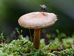 Röhrling mit Fliege im Bruderwald in Bamberg
 -
 Strand im Nationalpark Boddenlandschaft
 -
 Neuntöter im Geo-Naturpark Bergstraße-Odenwald


Wie du bei den Top 5 des vergangenen Jahres siehst, sind vor allem Tiere unter den Siegerbildern. Aus diesem Grund setzen wir den Fokus dieses Jahr stärker auf Landschaftsaufnahmen. Aber natürlich haben auch Tierbilder eine Chance zu gewinnen.
Es sind wie immer viele spannende Motive überall in Deutschland zu finden. Neben Naturdenkmälern wie alten Bäumen oder Naturparks im Gebirge und am Meer können Geotope wie Findlinge, Quellen und Aufschlüsse oder FFH-Gebiete fotografiert werden, um sie unter anderem in der Wikipedia zu dokumentieren. Auch im vergangenen Jahr sind zahlreiche neue Listen und Artikel in diesen Bereichen entstanden, für die wir uns über Fotos freuen. Als Einstieg für die Suche nach Motiven hilft diese Übersichtsseite. Weitere Informationen erhältst du bei WLE 2021 - Deutschland und unter dieser Anleitung. Falls du im Moment nicht wie sonst in die Natur fahren kannst, findest du vielleicht in den Tiefen deiner Festplatte oder auf dem Smartphone noch interessante Fotos.
Du bist interessiert, am Wettbewerb mitzuwirken, dir fehlt aber die richtige Technik? Dann wirf doch mal einen Blick in den Technikpool und das Technikleihportal von Wikimedia Deutschland! Dort findest du Kameras, Objektive und Zubehör verschiedenster Art.
Außerdem laden wir Dich ein, vom 1. Mai bis 30. Juni 2021 an der Vorjury teilzunehmen. Damit bewertest du die hochgeladenen Bilder und ermittelst so gemeinsam mit der Jury, die im Juli tagen wird, die Sieger von Wiki Loves Earth 2021 in Deutschland. Das Vorjurytool ist bald hier freigeschaltet. Du benötigst dafür nur deinen Benutzernamen und das Passwort.
Für Fragen steht das Organisationsteam gerne auf der Support-Seite zur Verfügung.
Viel Spaß und Erfolg beim Fotowettbewerb wünscht dir im Namen des Organisationsteams --Z thomas 11:32, 6 April 2021 (UTC)
File:Azerbaijan railway map.png and File:Azerbaijan railway map.svg need to be updated[edit]
Hello.
Can you update your maps File:Azerbaijan railway map.png and File:Azerbaijan railway map.svg, because a new 44.5 km long electrified single-track railway line that has connected the town of Qabala to the main Baku-Agstafa railway line in Ləki was opened on 16 May 2021.
Here are three sources (the first photo in the second source is actually using your map with the haphazardly added new railway line; and the third source does show the new railway line):
Yours sincerely, 31.200.14.164 08:12, 18 May 2021 (UTC)
- Can you privide sources on the railway network in Azerbaijan in general? It would make sense to check for any other changes. It may take some time, but should be done at least up to the end of the year. --Don-kun (talk) 16:47, 18 May 2021 (UTC)
- Hello. Thank you for the reply. I know that the sources I provided are inedaquate. I stumbled upon this news, and tried to find additional news sources about this with maps, which is difficult to find, because there are so few. Even railway maps about Azerbaijan in the internet are so few, inadequate and difficult to find. Even the official web site of Azerbaijan Railways does not have a map! Your map is one of the best and the most detailed, in the internet. I will continue to search for additional sources - hopefully with useful and detailed maps, and will inform you if I find one. Yours sincerely, 31.200.14.164 17:38, 18 May 2021 (UTC)
- To give you an update: I aim to make some more topographic maps of Azerbaijan. In the process I will have to incorporate all the railway lines in the country. After that, it will be relatively easy to comprise them into a map of the network as a whole. --Don-kun (talk) 19:47, 11 July 2021 (UTC)
- Hello. Thank you for the reply. I know that the sources I provided are inedaquate. I stumbled upon this news, and tried to find additional news sources about this with maps, which is difficult to find, because there are so few. Even railway maps about Azerbaijan in the internet are so few, inadequate and difficult to find. Even the official web site of Azerbaijan Railways does not have a map! Your map is one of the best and the most detailed, in the internet. I will continue to search for additional sources - hopefully with useful and detailed maps, and will inform you if I find one. Yours sincerely, 31.200.14.164 17:38, 18 May 2021 (UTC)
Hi! Thanks for the message! But, I wanted to talk about why the image is not copyrighted. Well, I found her on Pinterest, right? Anyone who saves an image on Pinterest pretty much owns it, that is, it owns its copyright. On Pinterest, there is actually no copyright, and everything is in the public domain. I saved the image on Pin and on my cell phone, so I have the right to put the image on Commons, and also in the public domain.
Thanks!
style="color:blue;font-family:Impact;font-size:12pt">Mayke]] à disposição
- Everything you said about copyright is false. The image is a screenshot of a tv series. The series has copyright protection. You can't upload any content of a tv series or any work created by a third party to commons without the permission of the creator/right holder. --Don-kun (talk) 16:22, 21 June 2021 (UTC)
Update request[edit]
Hello.
File:Topo map AZ AM de.png and File:Topo map AZ AM en.png need to be updated reflecting the current de facto border and situation, because the territory of Nagorno-Karabakh controlled by Armenians has been greatly reduced since 2020. The English version of the map automatically became obsolete, when it was created on 1 November 2020, when much territory was already lost vis-à-vis gained.
Yours sincerely, Artoxx (talk) 10:20, 26 June 2021 (UTC)
- No need for an update. The contents of the main topic of the map did not change. The map explicitly names the date for the borders shown. We don't know what borders will stay permanently. Updating this map does not make any sense until like 5 years in the future and then it will be not an update but a new map. --Don-kun (talk) 15:03, 26 June 2021 (UTC)
Wiki Loves Monuments 2021[edit]
Hallo Don-kun,
bald ist es soweit: Vom 1. bis zum 30. September 2021 findet zum elften Mal der internationale Wettbewerb Wiki Loves Monuments statt. Dabei können Bau-, Boden- und Kulturdenkmale fotografiert und die Fotos hochgeladen werden. Du hast an einem der vergangenen Fotowettbewerbe teilgenommen. Deshalb laden wir dich gern wieder ein, dieses Jahr mitzumachen. Wir freuen uns auf deine Fotos!
Obwohl es den Wettbewerb seit über zehn Jahren gibt, sind immer noch viele Motive überall in Deutschland zu fotografieren. Im Herzen Deutschlands in Thüringen und in Niedersachsen sind neue Denkmallisten entstanden, die auf Fotos warten. Übrigens in der Hauptstadt Thüringens in Erfurt findet dieses Jahr die WikiCon vom 1. bis 3. Oktober statt. Dies könnte man mit einem Foto-Kurzurlaub vor der WikiCon in Thüringen verbinden …
Vor dem Hintergrund der Flutkatastrophe 2021 haben wir auch drei Sonderpreise ausgelobt. Damit sollen Fotos prämiert werden, die Kulturdenkmale zeigen, die zerstört wurden. Das Foto kann das Objekt vor oder nach der Zerstörung zeigen.
Für die Suche nach Motiven gibt es bei Wikipedia zahlreiche Listen und Karten. Als Einstieg hilft diese Übersichtsseite. Weitere Informationen erhältst du auf der Mitmach-Seite.
Du bist interessiert, am Wettbewerb mitzuwirken, dir fehlt aber die richtige Technik? Dann wirf doch mal einen Blick in den Technikpool und das Technikleihportal von Wikimedia Deutschland! Dort findest du Kameras, Objektive und Zubehör verschiedenster Art.
Außerdem laden wir Dich ein, ab Anfang September 2021 an der Vorjury teilzunehmen. Diese bewertet die hochgeladenen Bilder und ermittelt so gemeinsam mit der Jury, die im Oktober tagt, die Sieger von Wiki Loves Monuments 2021 in Deutschland. Das Vorjurytool ist hier bald freigeschaltet. Du benötigst dafür nur deinen Benutzernamen und das Passwort.
Für Fragen steht das Organisationsteam gerne auf der Support-Seite zur Verfügung.
Viel Spaß und Erfolg beim größten Fotowettbewerb wünscht dir im Namen des Organisationsteams --Z thomas 18:29, 24 August 2021 (UTC)
Do not insert copyvio tags just to have a file deleted[edit]
I am referring to Staged_map_of_border_changes_in_Karabakh_as_per_2020_Armenia-_Azerbaijan_Agreement.png and to Commons:Deletion_requests/File:Staged_map_of_border_changes_in_Karabakh_as_per_2020_Armenia-_Azerbaijan_Agreement.png. --Ruthven (msg) 08:31, 29 October 2021 (UTC)
Blocked/heading[edit]
 |
You have been blocked from editing Commons for a duration of {{{1}}} for the following reason: {{{2}}}.
If you wish to make useful contributions, you may do so after the block expires. If you believe this block is unjustified, you may add {{unblock|(enter your reason here) ~~~~}} below this message explaining clearly why you should be unblocked. See also the block log. For more information, see Appealing a block.
|
Ruthven (msg) 14:55, 29 October 2021 (UTC)
- @Ruthven: This is highly abusive. Blocking for getting objected, blocking yourself and not letting a different admin decide... Then you reverted the false information back into File:Caucasus 1060n map de.png, even if that has nothing to do with the other issue ... you felt a bit like hounding other contributors? --Don-kun (talk) 08:21, 30 October 2021 (UTC)
- You pursued edit war regardless you were notified, and tried to overcome comunity decision of a DR by trying to request twice speedy deletion for a file that you want deleted for ideological reasons. Block confirmed, hoping that you'll change your behaviour once it ends. --Ruthven (msg) 12:52, 30 October 2021 (UTC)
- @Ruthven: There was never a community decision an that file. Just a DR and a ridiculous ruling by an admin, that in the meantime confirmed he didn't even look at the file. Otherwise he would have noticed the licencing issue. Thus even the one decision on the DR is invalid. The request for speedy deletion was valid and the questions raised are still not answered. You twice removed the request without even adressing the copyright issue. The you reverted a file (thus taking part in an edit war...) with no connection to the other to an erroneous version because some caucasian nationalist likes that more and ignores the sources given with the file. This is outright supporting misinformation by you. Plus now you are insulting me here on my talkpage. Also what a hybris to think you can confirm your own decision, unchecked by others. --Don-kun (talk) 14:55, 30 October 2021 (UTC)
- You pursued edit war regardless you were notified, and tried to overcome comunity decision of a DR by trying to request twice speedy deletion for a file that you want deleted for ideological reasons. Block confirmed, hoping that you'll change your behaviour once it ends. --Ruthven (msg) 12:52, 30 October 2021 (UTC)
- @Mdaniels5757 and A.Savin: I would like to ask you for a second (and possibly third) opinion on the reasoning and on the lenght of that block. And also on Ruthvens handling of File:Caucasus 1060n map de.png. Thanks. --Don-kun (talk) 05:59, 1 November 2021 (UTC)
- Responding to note that I have received your ping, and will look into this today or tomorrow. @Ruthven: could you please confirm which page(s) you blocked Don-kun for edit warring on (and if you had any other reasons to block)? —Mdaniels5757 (talk • contribs) 15:42, 2 November 2021 (UTC)
- @Mdaniels5757: The main issue is File:Staged map of border changes in Karabakh as per 2020 Armenia- Azerbaijan Agreement.png, where he proposed twice speedy deletion, regardless it was told him not to do so after a regular DR closed by Elcobbola. Checking some contribs, I found a pattern of reverts without explanations, but I haven't dig much (probably it's better, otherwise the block would have been muuuuch longer). Cheers Ruthven (msg) 12:03, 3 November 2021 (UTC)
- I don't really consider myself involved in this. Don-kun nominated File:Staged map of border changes in Karabakh as per 2020 Armenia- Azerbaijan Agreement.png for deletion with a purely scope-based rationale, which I closed when helping to reduce the substantial DR backlogs. As the file was in use on at least two projects at that time, I found Don-kun's rationale erroneous and cited two policies (COM:NPOV and COM:INUSE) supporting that finding--others have agreed ("Der erste Löschantrag war, das muss ich sagen, nicht gut"). Subsequent thereto, Don-kun unilaterally removed the image from the projects using it ([19][20]), without any discussion whatsoever, and as his first and only contributions to those projects ([21][22]). I consider this to be misbehaviour, and with the subsequent warring to insert an inappropriate {{Copyvio}} template in this context, to be petulant and intellectually dishonest. Эlcobbola talk 12:50, 3 November 2021 (UTC)
- @Mdaniels5757: The main issue is File:Staged map of border changes in Karabakh as per 2020 Armenia- Azerbaijan Agreement.png, where he proposed twice speedy deletion, regardless it was told him not to do so after a regular DR closed by Elcobbola. Checking some contribs, I found a pattern of reverts without explanations, but I haven't dig much (probably it's better, otherwise the block would have been muuuuch longer). Cheers Ruthven (msg) 12:03, 3 November 2021 (UTC)
- Responding to note that I have received your ping, and will look into this today or tomorrow. @Ruthven: could you please confirm which page(s) you blocked Don-kun for edit warring on (and if you had any other reasons to block)? —Mdaniels5757 (talk • contribs) 15:42, 2 November 2021 (UTC)
- Reverting isn’t bad per se. There are lots of reasons why it is sensible to revert, especially when it’s about maps. I have checked Don-kun’s latest 1000 edits (up to Sept. 29, 2020, so more than a year) and looked at the edits with "reverted" or "undo" in the edit summary. Where are the problematic edits? NNW 16:55, 3 November 2021 (UTC)
- @Mdaniels5757: Did you take a look? --Don-kun (talk) 22:20, 5 November 2021 (UTC)
- Thanks for reminding me; I must have somehow missed this in my watchlist.
- I do hesitate to say that the restoration of the copyvio tag is edit-warring (given that it was one revert), although I think nominating for deletion after the speedy was declined would have been a better choice. Removing the file on other projects without discussion, on the other hand, is rather naughty--Don-kun, do you have any comment on that?
- Also, you said that File:Staged map of border changes in Karabakh as per 2020 Armenia- Azerbaijan Agreement.png is an OpenStreetMap map; are you sure? It doesn't look like the ones that I remember, or that I see on openstreetmap.org. —Mdaniels5757 (talk • contribs) 00:03, 6 November 2021 (UTC)
- @Mdaniels5757: I agree that restoration of the copyvio and setting the speedy deletion tag after a DR with a different rationale could come over as naughty and seek a discussion with first Elcobbola and then after the first copyvio tag with Ruthven would have been better. But after having waited a year just another DR seemed not to be an option. As I saw the map again after 1 year I recognised it could not be done by the uploader alone and in this circumstances (licence/credit) thus would be a copyvio. I do not know if I had this thoughts 1 year ago or why I omited them in the DR if I did. Removing the files in those two projects for me was the logical conclusion of the statement by Elcobbola. The edits were explained, no one complained so far (one of the two articles even was edited after my edit) and there is no rule that I have to start a discussion before editing when I can give an explanation - at least as far as I know in any Wikipedia. Plus I don't know if anyone will ever answer to a discussion started by me there. So I don't see the problem here. On the other hand I feel it is quite kafkaesque to demand a discussion beeing held in different languages I don't speak when the problems of the map are errors in numerous ways and this is not a matter of POV.
- When I requested the speedy deletion, I recognised that the contents of the map were taken from OSM. As I worked this the data from this region myself and having observed the latest events, among others, in OSM there were some features that hint to OMS as the source without doubt. But it is not the usual renderer, as you have noticed. That does not matter concerning the protection of the map data, so it didn't matter for me. Plus the map also features elevation data (as hill shading) which is not a part of OSM data. So that has to be taken from a different, also unnamed source and thus added to my conclusion this was a copyvio. Later this discussion (see btw also the discussion below) between NNW and Ruthven showed the map was taken from OpenTopoMap. That opens the way for an use that is no infringing copyright. But at the moment, the map with false licence and lacking credits still is a copyvio. Ruthven and Elcobbola admitted there is a copyright issue with the file themselves in this discussion but then did nothing further.
- I want to stress my primary concern here is not the map that had the DR. I could live and have lived with low quality maps on Commons, even if I think the handling of this in particular is absurd. I am more astounded that 2 admins do not act against a copyright violation after they themselves have acknowledged it. What appalls me is Ruthvens disproportiate block. And what really terrifies me are his actions after that: messing in a matter that ha nothing to do with the other, that he does not understand and thus backing a self-proclaimed nationalist without evidence against evidence brought up by me; his repeated threads of another and even indefinit block when he sees any other edit from me he does not approve; the "logic" of seeing a pattern in just 2 edits; an admin and checkuser supporting all this behaviour ... --Don-kun (talk) 10:03, 6 November 2021 (UTC)
- @Mdaniels5757: Have you noticed my answer? --Don-kun (talk) 20:56, 8 November 2021 (UTC)
- I have. I think the block was too long -- if I did block, it would have been for a week maximum. I've unblocked you. —Mdaniels5757 (talk • contribs) 16:21, 10 November 2021 (UTC)
- At least something. Thanks. --Don-kun (talk) 18:48, 10 November 2021 (UTC)
- I have. I think the block was too long -- if I did block, it would have been for a week maximum. I've unblocked you. —Mdaniels5757 (talk • contribs) 16:21, 10 November 2021 (UTC)
- @Mdaniels5757, Ruthven, A.Savin, and Elcobbola: May anyone delete all uploads by this user as copyvio. Thanks. Oh and this one too. --Don-kun (talk) 11:39, 9 November 2021 (UTC)
- Done. —Mdaniels5757 (talk • contribs) 16:47, 10 November 2021 (UTC)
Wiki Loves Earth 2022 - Deutschland[edit]
Hallo Don-kun,
bald ist es soweit: Vom 1. Mai bis zum 30. Juni 2024 findet zum zwölften Mal der internationale Wettbewerb Wiki Loves Earth (kurz: WLE) statt. Dabei können wie immer Nationalparks, Naturschutzgebiete, Geotope und Naturdenkmäler oder andere Schutzgebiete fotografiert und die Fotos hochgeladen werden. Du hast an einem der vergangenen Fotowettbewerbe teilgenommen. Deshalb laden wir dich ein, auch dieses Jahr wieder mitzumachen. Wir freuen uns auf deine Fotos!
- Sieger WLE 2023 – Landschaft
-
 Ramsach, ein linker Zufluss zur Loisach im oberbayerischen FFH-Gebiet Murnauer Moos
 -
 Naturdenkmal Sankt-Anna-Linde, eine ca. 300 Jahre alte Winterlinde (Tilia cordata) auf einer Anhöhe südöstlich des Heilbronner Ortsteils Kirchhausen
 -
 Buchenwald im Nationalpark Jasmund nach einem Regenschauer


- Sieger WLE 2023 – Detail
-
 Großer Blaupfeil (Orthetrum cancellatum) im Naturschutzgebiet Gülper See
 -
 Blüte des Knöllchen-Steinbrechs (Saxifraga granulata) im Naturschutzgebiet Dattenbachtal zwischen Kröftel und Vockenhausen (Taunus)
 -
 männliche Rohrweihe (Circus aeruginosus) beim Jagdflug im Osten Spiekeroogs, Nationalpark Niedersächsisches Wattenmeer


Der Wettbewerb ist zweigeteilt, das heißt, wir unterscheiden zwischen den beiden Wettbewerbskategorien Landschaft und Detail/Makro. Zur Wettbewerbskategorie Landschaft zählen auch geschützte Einzelbäume. In der Wettbewerbskategorie Detail/Makro werden Pflanzen, Tiere und Pilze in den Schutzgebieten bewertet.
Es sind wie immer viele spannende Motive überall in Deutschland zu finden. Neben Naturdenkmälern wie alten Bäumen oder Naturparks im Gebirge und am Meer können Geotope wie Findlinge, Quellen und Aufschlüsse oder FFH-Gebiete fotografiert werden, um sie unter anderem in der Wikipedia zu dokumentieren. Auch im vergangenen Jahr sind zahlreiche neue Listen und Artikel in diesen Bereichen entstanden, die sich über Fotos freuen – zum Beispiel in Bayern die Liste der Naturdenkmäler im Landkreis Landshut oder die Liste der geschützten Landschaftsbestandteile in Mecklenburg-Vorpommern mit ihren Unterlisten oder gar einzelne Artikel wie die Landschaftsschutzgebiete Sommerschafweide an Buchhalden und Sommerschafweide auf Hilbertswiese in Baden-Württemberg.
Wir vergeben in diesem Jahr drei Sonderpreise für Fotos von Feldrainen und Feldgehölzen in geschützten Gebieten.
Als Einstieg für die Suche nach Motiven hilft diese Übersichtsseite. Weitere Informationen erhältst du bei WLE 2024 – Deutschland und unter dieser Anleitung.
Damit es ab 1. Mai mit dem Upload schnell geht:
Außerdem laden wir dich ein, vom 15. Mai bis Mitte Juli 2024 an der Vorjury teilzunehmen. Damit bewertest du die hochgeladenen Bilder und ermittelst so gemeinsam mit der Jury, die Anfang August tagen wird, die Sieger von Wiki Loves Earth 2024 in Deutschland. Das Vorjurytool ist bald hier freigeschaltet. Du benötigst dafür nur deinen Benutzernamen und Passwort.
Für Fragen steht das Organisationsteam gerne auf der Support-Seite zur Verfügung. Falls du im nächsten Jahr keine Einladung für Wiki Loves Earth Deutschland haben möchtest, trag dich bitte hier ein. Wir würden das natürlich schade finden, da wir uns auf deine Fotos freuen.
Viel Spaß und Erfolg beim Fotowettbewerb 2024 wünscht dir im Namen des Organisationsteams --~~~~
Borders of Heniochi[edit]
Hello @Don-kun! Recently I got interested into history of ancient tribes in eastern black sea coast. Your maps are great, however I got question regarding to borders of Heniochi [File:Caucasus 250 AD map alt de.png]. Almost every source I have read write that Lazica extended its border to Apsaros, while south of it were Zydrites and south of them were so called tribal union of Macrones and Heniochi, which are first mentioned in 2nd century A.D. by Arrianes, earlier to this in 1st century A.D. near Trebizond we have another union called "gens Sannorum Heniochorum". My question is: why you separated Heniochi from Macrones? and what are the reason to put them between Rioni (Phasis) and Coruh rivers? The area that you have marked as Heniochi is original Laz homeland (check Braund), from where Lazs have captured Colchis (Egrisi) heartland. It also noteworthy to mention that even 7th century Armenian geography divides Colchis in several parts: "Mainrivliv, Egrevikiv, Laziv and Chaniv, which is Khaltik" (I could make some mistakes in transcliptions). Mainrivliv is said to be (M)argveti, Egrevikiv is Egrisi, Laziv is modern day Guria and western parts of Adjara, and Chaniv or Khaltik is Chaldia (including Rize). According to Byzantine sources Chaniv or Tzanica was located between Byzantine Empire and Lazica, it included several settlements: Athenae, Archabis and Apsar (almost all of them are located in Rize province, except Apsar). Heniochi are described as mountanious tribes that migrated to coastlands and mixed with Sanni and Macrones (Machelones). Nothing about Lazian and Heniochian relations are written in sources, the only thing which seems to be clear is that they were leading force of Macron-Heniochian union, which according to the sources comprised Rize province. I would kindly ask you to modify the map to align it with the sources, or please, show me source which supports the claim that Heniochi were living between Rioni and Coruh rivers. With regards. Georgiano (talk) 08:41, 5 July 2022 (UTC)
Wiki Loves Monuments 2022[edit]
Hallo Don-kun,
bald ist es soweit: Vom 1. bis zum 30. September 2022 findet zum zwölften Mal der internationale Wettbewerb Wiki Loves Monuments (WLM) statt. Dabei können Bau-, Boden- und Kulturdenkmale fotografiert und die Fotos hochgeladen werden. Du hast an einem der vergangenen Fotowettbewerbe teilgenommen. Deshalb laden wir dich gern wieder ein, dieses Jahr mitzumachen. Wir freuen uns auf deine Fotos!

Vergangenes Jahr hat Matthias Süßen mit einer Drohnenaufnahme von Schloss Langenburg im Morgennebel gewonnen. Welcher Fotograf wird dieses Jahr sein Nachfolger?
Nach WLM 2022 sind wieder zahlreiche neue Denkmallisten entstanden – zum Beispiel die Denkmallisten in Cloppenburg oder in Oldenburg.
Wir haben dieses Jahr unter dem Motto „Klein aber Oho“ drei Sonderpreise für Kleindenkmale ausgelobt. Damit sollen Fotos prämiert werden, die die unterschätzten Kleindenkmale wie Grenzsteine oder Bildstöcke zeigen.
Für die Suche nach Motiven gibt es bei Wikipedia zahlreiche Listen und Karten. Als Einstieg hilft diese Übersichtsseite. Weitere Informationen erhältst du auf der Mitmach-Seite.
Außerdem laden wir Dich ein, ab Anfang September 2022 an der Vorjury teilzunehmen. Diese bewertet die hochgeladenen Bilder und ermittelt so gemeinsam mit der Jury, die im Oktober tagt, die Sieger von Wiki Loves Monuments 2022 in Deutschland. Das Vorjurytool ist hier bald freigeschaltet. Du benötigst dafür nur deinen Benutzernamen und das Passwort.
Für Fragen steht das Organisationsteam gerne auf der Support-Seite zur Verfügung.
Viel Spaß und Erfolg beim größten Fotowettbewerb wünscht dir im Namen des Organisationsteams --Z thomas 06:08, 26 August 2022 (UTC)
Wiki Loves Earth 2023 - Deutschland[edit]
Hallo Don-kun,
bald ist es soweit: Vom 1. Mai bis zum 31. Mai 2023 findet zum elften Mal der internationale Wettbewerb Wiki Loves Earth statt. Dabei können unter anderem Nationalparks, Naturschutzgebiete, Geotope und Naturdenkmäler fotografiert und die Fotos hochgeladen werden. Du hast an einem der vergangenen Fotowettbewerbe teilgenommen. Deshalb laden wir dich ein, auch dieses Jahr wieder mitzumachen. Wir freuen uns auf deine Fotos!
- Sieger WLE 2022 – Landschaft
-
 Hohes Ufer zwischen Ahrenshoop und Wustrow, Fischland
 -
 Biotop Nördliche Lothdorfer Wiese
 -
 Aisch bei Willersdorf im FFH Aischgrund


- Sieger WLE 2022 – Detail
-
 Gemeine Goldwespe im NSG Wittenberge Rühstädter Elbniederung
 -
 Libellen-Schmetterlingshaft im Naturschutzgebiet Badberg (Kaiserstuhl)
 -
 Blüte eines Schmalblättrigen Weidenröschens im Naturpark Taunus

.jpg)

_-_Vazha-Pshavela,_1991.jpg)
_-_Vazha-Pshavela,_1991.jpg)
_-_Vazha-Pshavela,_1991.jpg)
![[2]](https://de.wikipedia.org/wiki/Datei:Tram_map_Lisbon_2011.png)
![[6]](https://commons.wikimedia.org/wiki/File:Ahmadiyya_Jabrayilov_and_Jacques_Duclos.JPG)
![[7]](https://commons.wikimedia.org/wiki/File:Rachida_Dati_in_House-museum_of_Ahmadiyya_Jabrayilov_2.JPG)
![[8]](https://commons.wikimedia.org/wiki/File:Rachida_Dati_in_House-museum_of_Ahmadiyya_Jabrayilov_3.JPG)
![[9]](https://commons.wikimedia.org/wiki/File:Rachida_Dati_in_House-museum_of_Ahmadiyya_Jabrayilov.JPG)
![[11]](https://commons.wikimedia.org/wiki/File:Azerbaijan_adm_location_map.svg)
![[12]](https://commons.wikimedia.org/wiki/File:Transcaucasia_adm_location_map.svg)
![[15]](https://upload.wikimedia.org/wikipedia/commons/archive/1/12/20100220174208%21Caucasus_1060n_map_de.png)
![[17]](http://www.iriston.com/books/cuciev_-_etno_atlas/maps/map46.jpg)
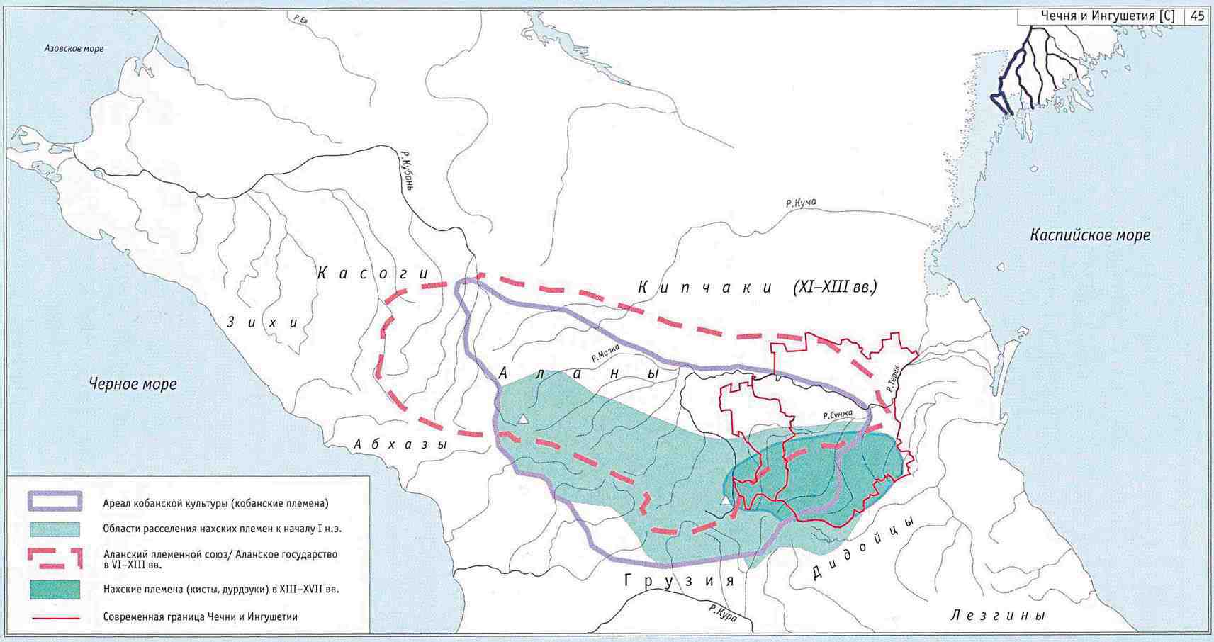
Der Wettbewerb ist zweigeteilt, das heißt wir unterscheiden zwischen den beiden Wettbewerbskategorien Landschaft und Detail/Makro. Zu Landschaft zählen auch geschützte Einzelbäume. In der Wettbewerbskategorie Detail/Makro werden Pflanzen, Tiere und Pilze bewertet.
Es sind wie immer viele spannende Motive überall in Deutschland zu finden. Neben Naturdenkmälern wie alten Bäumen oder Naturparks im Gebirge und am Meer können Geotope wie Findlinge, Quellen und Aufschlüsse oder FFH-Gebiete fotografiert werden, um sie unter anderem in der Wikipedia zu dokumentieren. Auch im vergangenen Jahr sind zahlreiche neue Listen und Artikel in diesen Bereichen entstanden, für die wir uns über Fotos freuen – zum Beispiel in Sachsen die Liste der Naturdenkmale in Wurzen.
Als Einstieg für die Suche nach Motiven hilft diese Übersichtsseite. Weitere Informationen erhältst du bei WLE 2023 – Deutschland und unter dieser Anleitung.
Damit der Upload für dich einfacher ist, haben wir in diesem Jahr die einzelnen Hochladeseiten für die Bundesländer abgeschafft, alle Fotos werden über dasselbe Formular hochgeladen. Außerdem haben wir das Layout unserer WLE-Seiten geändert.
Damit es ab 1. Mai mit dem Upload schnell geht:
Außerdem laden wir dich ein, vom 1. Mai bis 30. Juni 2023 an der Vorjury teilzunehmen. Damit bewertest du die hochgeladenen Bilder und ermittelst so gemeinsam mit der Jury, die im Juli tagen wird, die Sieger von Wiki Loves Earth 2023 in Deutschland. Das Vorjurytool ist bald hier freigeschaltet. Du benötigst dafür nur deinen Benutzernamen und das Passwort.
Für Fragen steht das Organisationsteam gerne auf der Support-Seite zur Verfügung. Falls du im nächsten Jahr keine Einladung für Wiki Loves Earth Deutschland haben möchtest, trag dich bitte hier ein. Wir würden das natürlich schade finden, da wir uns auf deine Fotos freuen.
Viel Spaß und Erfolg beim Fotowettbewerb 2023 wünscht dir im Namen des Organisationsteams --Z thomas 16:52, 18 April 2023 (UTC)
Correction request[edit]
Hello Don-kun,
Can you do corrections in the maps File:Topo map Arzach de.png, File:Topo map Artsakh en.png and File:Topo map Nakhchiva de.png, File:Topo map Nakhchivan en.png? The railway lines in Nakhchivan are in service (both passenger and freight) up to the borders of Armenia, and have remained so even after Nagorno-Karabakh was occupied by Armenians, and was cut off from the rest of Azerbaijan. On the other hand, the railway lines in Nagorno-Karabakh, which are now under Azerbaijani control, are still out of service.
Here are sources in Azerbaijani, which can be translated via a machine translator:
https://ntv.az/news/iqtisadiyyat/53843-naxcivanda-demiryolu-neqliyyati-inkisaf-etdirilir
Yours sincerely, Multituberculata (talk) 18:54, 24 June 2023 (UTC)
Update request[edit]
Hello Don-kun,
Can you update File:Topo map AZ AM de.png and File:Topo map AZ AM en.png, by redrawing the de facto line of control of Nagorno-Karabakh? Since the territory, not under Azerbaijani control, is much reduced since 2020, the actual de facto situation should be shown. Almost three years have passed since the Second Nagorno-Karabakh War, and the line of control has not changed.
Yours sincerely, Multituberculata (talk) 18:54, 24 June 2023 (UTC)
Wiki Loves Monuments 2023 - Deutschland[edit]
Hallo Don-kun,

bald ist es soweit: Vom 1. bis zum 30. September 2023 findet zum dreizehnten Mal der internationale Wettbewerb Wiki Loves Monuments (WLM) statt. Dabei können Bau-, Boden- und Kulturdenkmale fotografiert und die Fotos hochgeladen werden. Du hast an einem der vergangenen Fotowettbewerbe teilgenommen. Deshalb laden wir dich gern wieder ein, dieses Jahr mitzumachen. Wir freuen uns auf deine Fotos!
Vergangenes Jahr hat Radomianin mit einer Gesamtansicht von Kloster Paulinzella gewonnen. Welcher Fotograf oder welche Fotografin tritt dieses Jahr die Nachfolge an?
Nach WLM 2022 sind wieder zahlreiche neue Denkmallisten entstanden – zum Beispiel die Denkmallisten in Waltershausen in Thüringen oder in Fulda.
Für die Suche nach Motiven gibt es bei Wikipedia zahlreiche Listen und Karten. Als Einstieg hilft diese Übersichtsseite. Weitere Informationen erhältst du auf der Mitmach-Seite.
Für das einfache Auffinden haben wir eine Upload-Karte erstellt, in der viele aber leider noch nicht alle Kulturdenkmale angezeigt werden können. Das Laden der Objekte dauert dort etwas.
Wir haben dieses Jahr „drei Sonderpreise für Bilder von Friedhöfen“ ausgelobt. Zugelassen sind für den Sonderpreis auch Fotos von Friedhöfen, die nicht denkmalgeschützt sind.
Damit es ab 1. September mit dem Upload schnell geht:
Außerdem laden wir Dich ein, ab Anfang September 2023 an der Vorjury teilzunehmen. Diese bewertet die hochgeladenen Bilder und ermittelt so gemeinsam mit der Jury, die im Oktober tagt, die Sieger von Wiki Loves Monuments 2023 in Deutschland. Das Vorjurytool ist hier bald freigeschaltet. Du benötigst dafür nur deinen Benutzernamen und das Passwort.
Für Fragen steht das Organisationsteam gerne auf der Support-Seite zur Verfügung. Falls du im nächsten Jahr keine Einladung für Wiki Loves Monuments Deutschland haben möchtest, trag dich bitte hier ein. Wir würden das natürlich schade finden, da wir uns auf deine Fotos freuen.
Viel Spaß und Erfolg beim größten Fotowettbewerb wünscht dir im Namen des Organisationsteams --Z thomas 12:19, 19 August 2023 (UTC)
Wiki Loves Earth 2024 - Deutschland[edit]
Hallo Don-kun,
bald ist es soweit: Vom 1. Mai bis zum 30. Juni 2024 findet zum zwölften Mal der internationale Wettbewerb Wiki Loves Earth (kurz: WLE) statt. Dabei können wie immer Nationalparks, Naturschutzgebiete, Geotope und Naturdenkmäler oder andere Schutzgebiete fotografiert und die Fotos hochgeladen werden. Du hast an einem der vergangenen Fotowettbewerbe teilgenommen. Deshalb laden wir dich ein, auch dieses Jahr wieder mitzumachen. Wir freuen uns auf deine Fotos!
- Sieger WLE 2023 – Landschaft
-
Ramsach, ein linker Zufluss zur Loisach im oberbayerischen FFH-Gebiet Murnauer Moos
-
Naturdenkmal Sankt-Anna-Linde, eine ca. 300 Jahre alte Winterlinde (Tilia cordata) auf einer Anhöhe südöstlich des Heilbronner Ortsteils Kirchhausen
-
Buchenwald im Nationalpark Jasmund nach einem Regenschauer
- Sieger WLE 2023 – Detail
-
Großer Blaupfeil (Orthetrum cancellatum) im Naturschutzgebiet Gülper See
-
Blüte des Knöllchen-Steinbrechs (Saxifraga granulata) im Naturschutzgebiet Dattenbachtal zwischen Kröftel und Vockenhausen (Taunus)
-
männliche Rohrweihe (Circus aeruginosus) beim Jagdflug im Osten Spiekeroogs, Nationalpark Niedersächsisches Wattenmeer
Der Wettbewerb ist zweigeteilt, das heißt, wir unterscheiden zwischen den beiden Wettbewerbskategorien Landschaft und Detail/Makro. Zur Wettbewerbskategorie Landschaft zählen auch geschützte Einzelbäume. In der Wettbewerbskategorie Detail/Makro werden Pflanzen, Tiere und Pilze in den Schutzgebieten bewertet.
Es sind wie immer viele spannende Motive überall in Deutschland zu finden. Neben Naturdenkmälern wie alten Bäumen oder Naturparks im Gebirge und am Meer können Geotope wie Findlinge, Quellen und Aufschlüsse oder FFH-Gebiete fotografiert werden, um sie unter anderem in der Wikipedia zu dokumentieren. Auch im vergangenen Jahr sind zahlreiche neue Listen und Artikel in diesen Bereichen entstanden, die sich über Fotos freuen – zum Beispiel in Bayern die Liste der Naturdenkmäler im Landkreis Landshut oder die Liste der geschützten Landschaftsbestandteile in Mecklenburg-Vorpommern mit ihren Unterlisten oder gar einzelne Artikel wie die Landschaftsschutzgebiete Sommerschafweide an Buchhalden und Sommerschafweide auf Hilbertswiese in Baden-Württemberg.
Wir vergeben in diesem Jahr drei Sonderpreise für Fotos von Feldrainen und Feldgehölzen in geschützten Gebieten.
Als Einstieg für die Suche nach Motiven hilft diese Übersichtsseite. Weitere Informationen erhältst du bei WLE 2024 – Deutschland und unter dieser Anleitung.
Damit es ab 1. Mai mit dem Upload schnell geht:
Außerdem laden wir dich ein, vom 15. Mai bis Mitte Juli 2024 an der Vorjury teilzunehmen. Damit bewertest du die hochgeladenen Bilder und ermittelst so gemeinsam mit der Jury, die Anfang August tagen wird, die Sieger von Wiki Loves Earth 2024 in Deutschland. Das Vorjurytool ist bald hier freigeschaltet. Du benötigst dafür nur deinen Benutzernamen und Passwort.
Für Fragen steht das Organisationsteam gerne auf der Support-Seite zur Verfügung. Falls du im nächsten Jahr keine Einladung für Wiki Loves Earth Deutschland haben möchtest, trag dich bitte hier ein. Wir würden das natürlich schade finden, da wir uns auf deine Fotos freuen.
Viel Spaß und Erfolg beim Fotowettbewerb 2024 wünscht dir im Namen des Organisationsteams --Z thomas 17:48, 24 April 2024 (UTC)