| Location
|
Upload
|
Photo
|
Object
|
Cat.
|
Coordinates
|
KGS-Nr
|
| Solothurn
|

|
yes
|


|
Franziskanerkirche
|
B
|
47°12′32″N 7°32′15″E / 47.20898325°N 7.537588789°E / 47.20898325; 7.537588789
|
4700
|
| Solothurn
|
|
yes
|
|
Konzertsaal Solothurn
|
B
|
47°12′35″N 7°32′11″E / 47.2097399°N 7.536309793°E / 47.2097399; 7.536309793
|
4718
|
| Solothurn
|
|
yes
|
|
Rythalle Solothurn
|
B
|
47°12′35″N 7°32′27″E / 47.209735955°N 7.540863787°E / 47.209735955; 7.540863787
|
11088
|
| Solothurn
|
|
yes
|
|
Kapuzinerkloster Solothurn
|
B
|
47°12′40″N 7°31′58″E / 47.211181913°N 7.532880341°E / 47.211181913; 7.532880341
|
4717
|
| Solothurn
|
|
yes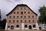
|
|
Museum Altes Zeughaus
|
A
|
47°12′32″N 7°32′19″E / 47.208995°N 7.538715°E / 47.208995; 7.538715
|
4685
|
| Solothurn
|
|
yes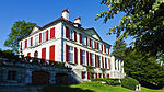
|
|
Schloss Blumenstein
|
A
|
47°12′59″N 7°32′12″E / 47.216413888°N 7.536630555°E / 47.216413888; 7.536630555
|
4689
|
| Solothurn
|
|
yes
|
|
Jesuitenkirche
|
A
|
47°12′28″N 7°32′17″E / 47.207809°N 7.537934°E / 47.207809; 7.537934
|
4684
|
| Solothurn
|
|
yesZentralbibliothek Solothurn
|
|
Zentralbibliothek Solothurn
|
A
|
47°12′35″N 7°31′47″E / 47.209722222°N 7.529722222°E / 47.209722222; 7.529722222
|
9182
|
| Solothurn
|
|
yes
|
|
Naturmuseum Solothurn
|
A
|
47°12′26″N 7°32′22″E / 47.20728°N 7.539345°E / 47.20728; 7.539345
|
8592
|
| Solothurn
|
|
yes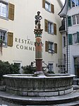
|
|
Simsonbrunnen
|
B
|
47°12′26″N 7°32′07″E / 47.207132311°N 7.535249067°E / 47.207132311; 7.535249067
|
4735
|
| Solothurn
|
|
yes
|
|
Bahnhof Solothurn
|
B
|
47°12′15″N 7°32′34″E / 47.204233333°N 7.542713888°E / 47.204233333; 7.542713888
|
13996
|
| Solothurn
|
|
yes
|
|
Staatsarchiv des Kantons Solothurn
|
A
|
47°12′36″N 7°31′44″E / 47.21002°N 7.528764°E / 47.21002; 7.528764
|
8794
|
| Solothurn
|
|

|
|
Archiv des Bistums Basel
|
B
|
47°12′44″N 7°32′48″E / 47.212222277°N 7.546571188°E / 47.212222277; 7.546571188
|
8902
|
| Solothurn
|
|
|
|
Bürgerarchiv Solothurn
|
B
|
47°12′19″N 7°32′10″E / 47.205215583°N 7.536248709°E / 47.205215583; 7.536248709
|
10590
|
| Solothurn
|
|
|
|
Domschatz
|
B
|
47°12′30″N 7°32′23″E / 47.208450752°N 7.539673352°E / 47.208450752; 7.539673352
|
8622
|
| Solothurn
|
|
yes
|
|
Kosciuszko Museum
|
B
|
47°12′29″N 7°32′11″E / 47.208030864°N 7.536346261°E / 47.208030864; 7.536346261
|
4719
|
| Solothurn
|
|
yes
|
|
Puppen- und Spielzeugmuseum
|
B
|
47°12′27″N 7°32′22″E / 47.207425478°N 7.539526215°E / 47.207425478; 7.539526215
|
11000
|
| Solothurn
|
|
yes
|
|
Rathaus
|
A
|
47°12′28″N 7°32′13″E / 47.207845°N 7.536971°E / 47.207845; 7.536971
|
4687
|
| Solothurn
|
|
yes
|
|
Frauenkloster Visitation
|
A
|
47°12′45″N 7°31′47″E / 47.212628°N 7.529627°E / 47.212628; 7.529627
|
4682
|
| Solothurn
|
|
yes
|
|
Haller-Haus (Bischöfliches Palais)
|
A
|
47°12′47″N 7°32′44″E / 47.213154°N 7.545666°E / 47.213154; 7.545666
|
4683
|
| Solothurn
|
|
yes
|
|
Mauritiusbrunnen
|
A
|
47°12′31″N 7°32′20″E / 47.208491°N 7.538899°E / 47.208491; 7.538899
|
4726
|
| Solothurn
|
|
yes
|
|
Reformierte Kirche
|
A
|
47°12′34″N 7°32′06″E / 47.20934°N 7.534901°E / 47.20934; 7.534901
|
4734
|
| Solothurn
|
|
yes
|
|
Schloss Steinbrugg
|
A
|
47°12′44″N 7°32′48″E / 47.212217°N 7.546575°E / 47.212217; 7.546575
|
4690
|
| Solothurn
|
|
|
|
Sommerhaus Vigier
|
A
|
47°12′45″N 7°32′03″E / 47.212408°N 7.534049°E / 47.212408; 7.534049
|
4691
|
| Solothurn
|
|
yes
|
|
Stadtbefestigung
|
A
|
47°12′25″N 7°32′15″E / 47.207035°N 7.537629°E / 47.207035; 7.537629
|
10174
|
| Solothurn
|
|
yes
|
|
Zeitglockenturm
|
A
|
47°12′27″N 7°32′13″E / 47.207585°N 7.536904°E / 47.207585; 7.536904
|
4693
|
| Solothurn
|
|
yes
|
|
Aarhof (1620)
|
B
|
47°12′13″N 7°31′54″E / 47.203582309°N 7.531679043°E / 47.203582309; 7.531679043
|
4695
|
| Solothurn
|
|
|
|
Amthaus I (1869)
|
B
|
47°12′29″N 7°32′00″E / 47.208123266°N 7.533402918°E / 47.208123266; 7.533402918
|
4696
|
| Solothurn
|
|
|
|
Benzigerhof
|
B
|
47°12′34″N 7°32′31″E / 47.209366205°N 7.54194547°E / 47.209366205; 7.54194547
|
11090
|
| Solothurn
|
|
yes
|
|
Bürgerhaus (1733, 1798)
|
B
|
47°12′19″N 7°32′10″E / 47.205215583°N 7.536248709°E / 47.205215583; 7.536248709
|
4698
|
| Solothurn
|
|
yes
|
|
Cartierhof (1575, 1680) mit Oekonomiegebäuden
|
B
|
47°12′43″N 7°32′21″E / 47.212076032°N 7.539218193°E / 47.212076032; 7.539218193
|
4699
|
| Solothurn
|
|
yes
|
|
Chüngeligraben-Magazin
|
B
|
47°12′33″N 7°32′10″E / 47.209200438°N 7.536044807°E / 47.209200438; 7.536044807
|
11084
|
| Solothurn
|
|
yes
|
|
Ehemalige Klosterkirche St. Josef (um 1650) und Kloster St. Joseph
|
B
|
47°12′38″N 7°32′33″E / 47.210544°N 7.542515352°E / 47.210544; 7.542515352
|
4702
|
| Solothurn
|
|
yes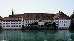
|
|
Ehemaliges Bürgerspital (1735, 1800)
|
B
|
47°12′17″N 7°32′08″E / 47.204856438°N 7.535482521°E / 47.204856438; 7.535482521
|
13991
|
| Solothurn
|
|
|
|
Ehemaliges Klostergebäude (1664)
|
B
|
47°12′34″N 7°32′17″E / 47.209522583°N 7.537998989°E / 47.209522583; 7.537998989
|
13990
|
| Solothurn
|
|
|
|
Evangelisch-methodistische Kapelle
|
B
|
47°12′35″N 7°31′51″E / 47.209744459°N 7.530765798°E / 47.209744459; 7.530765798
|
11082
|
| Solothurn
|
|
yes
|
|
Fegetzhof (um 1840)
|
B
|
47°12′59″N 7°32′30″E / 47.216481211°N 7.541734787°E / 47.216481211; 7.541734787
|
4703
|
| Solothurn
|
|
yes
|
|
Frauenkloster Nominis Jesu (Kirche 1620)
|
B
|
47°12′51″N 7°32′03″E / 47.214059143°N 7.534205532°E / 47.214059143; 7.534205532
|
4704
|
| Solothurn
|
|
yes
|
|
Gebäude Schweizerische Volksbank (1928)
|
B
|
47°12′23″N 7°32′04″E / 47.206503448°N 7.534323983°E / 47.206503448; 7.534323983
|
4705
|
| Solothurn
|
|
|
|
Gemeindehaus (Haus Stäffis-Mollondin, 1580, 1700)
|
B
|
47°12′31″N 7°32′14″E / 47.208659857°N 7.537099799°E / 47.208659857; 7.537099799
|
4706
|
| Solothurn
|
|
yes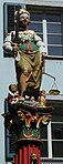
|
|
Gerechtigkeitsbrunnen (1561)
|
B
|
47°12′26″N 7°32′10″E / 47.207122594°N 7.536107008°E / 47.207122594; 7.536107008
|
4707
|
| Solothurn
|
|
yes
|
|
Haus Dr. Reinert (1692)
|
B
|
47°12′28″N 7°32′10″E / 47.207851225°N 7.536042342°E / 47.207851225; 7.536042342
|
4709
|
| Solothurn
|
|
|
|
Haus Gressly im Kreuzacker (17. und 18. Jh.)
|
B
|
47°12′20″N 7°32′16″E / 47.205600962°N 7.537886089°E / 47.205600962; 7.537886089
|
4710
|
| Solothurn
|
|
yes
|
|
Haus Von Sury-de Vigier (17.-19. Jh.)
|
B
|
47°12′29″N 7°32′17″E / 47.208047308°N 7.538154634°E / 47.208047308; 7.538154634
|
4711
|
| Solothurn
|
|
yes
|
|
Hermesbühlschulhaus
|
B
|
47°12′35″N 7°31′53″E / 47.209851878°N 7.531412786°E / 47.209851878; 7.531412786
|
11083
|
| Solothurn
|
|
yes
|
|
Hotel Krone (1772)
|
B
|
47°12′29″N 7°32′19″E / 47.207939029°N 7.538550419°E / 47.207939029; 7.538550419
|
4712
|
| Solothurn
|
|
|
|
Kaiser-Haus (19. Jh.)
|
B
|
47°12′41″N 7°32′05″E / 47.211441281°N 7.534676057°E / 47.211441281; 7.534676057
|
4715
|
| Solothurn
|
|
|
|
Kapelle (1773) und Pfrundhaus (z.T. 17. Jh.) zu St. Katharinen
|
B
|
47°12′59″N 7°32′58″E / 47.21638402°N 7.549523546°E / 47.21638402; 7.549523546
|
4716
|
| Solothurn
|
|
yes
|
|
Kapelle St. Urban
|
B
|
47°12′31″N 7°32′07″E / 47.208499381°N 7.535409941°E / 47.208499381; 7.535409941
|
11085
|
| Solothurn
|
|
|
|
Kapitelhaus und ehemaliges St. Ursen-Schulhaus
|
B
|
47°12′31″N 7°32′24″E / 47.208558481°N 7.539911151°E / 47.208558481; 7.539911151
|
11086
|
| Solothurn
|
|
yes
|
|
Katholische Spitalkirche zum Hl. Geist (1736)
|
B
|
47°12′18″N 7°32′09″E / 47.205098975°N 7.535865729°E / 47.205098975; 7.535865729
|
4713
|
| Solothurn
|
|
yes
|
|
Katholische Weststadtkirche St. Marien (1954, Glasgemälde von H. Stocker)
|
B
|
47°12′40″N 7°30′59″E / 47.211104148°N 7.516511955°E / 47.211104148; 7.516511955
|
4714
|
| Solothurn
|
|
yes
|
|
Kullyhaus
|
B
|
47°12′53″N 7°32′33″E / 47.214600561°N 7.542576036°E / 47.214600561; 7.542576036
|
11093
|
| Solothurn
|
|
yes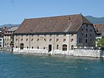
|
|
Landhaus (1722, 1955)
|
B
|
47°12′23″N 7°32′16″E / 47.206500551°N 7.537755771°E / 47.206500551; 7.537755771
|
4721
|
| Solothurn
|
|
|
|
Landsitz Glutzenhübeli (17.-19. Jh.) mit ehemaligem Gutshof (Lischerhof, um 1700)
|
B
|
47°12′57″N 7°31′55″E / 47.215949818°N 7.532030664°E / 47.215949818; 7.532030664
|
4722
|
| Solothurn
|
|
|
|
Loretohof (1710) und Villen des Loretoquartiers (um 1900)
|
B
|
47°12′49″N 7°31′56″E / 47.213701085°N 7.532092736°E / 47.213701085; 7.532092736
|
4723
|
| Solothurn
|
|
yes
|
|
Loretokapelle (1649) und Bauernhof (17. Jh.) an der Klostermatte mit Altwyberhüsli
|
B
|
47°12′44″N 7°31′56″E / 47.21235166°N 7.532354383°E / 47.21235166; 7.532354383
|
4724
|
| Solothurn
|
|
yes
|
|
Naturmuseum (1765, Pisoni)
|
B
|
47°12′26″N 7°32′22″E / 47.207286°N 7.539345°E / 47.207286; 7.539345
|
4728
|
| Solothurn
|
|
yes
|
|
Neuer Lindenhof
|
B
|
47°12′47″N 7°32′30″E / 47.213063228°N 7.541728198°E / 47.213063228; 7.541728198
|
4729
|
| Solothurn
|
|
yes
|
|
Palais Besenval (1705)
|
B
|
47°12′24″N 7°32′20″E / 47.206769482°N 7.538812213°E / 47.206769482; 7.538812213
|
4730
|
| Solothurn
|
|
|
|
Patrizierhaus
|
B
|
47°12′31″N 7°31′50″E / 47.208719173°N 7.530618829°E / 47.208719173; 7.530618829
|
4732
|
| Solothurn
|
|
|
|
Patrizierhaus Güetli
|
B
|
47°12′46″N 7°32′41″E / 47.21281761°N 7.544763891°E / 47.21281761; 7.544763891
|
4731
|
| Solothurn
|
|
yes
|
|
Pfarrhaus St. Ursen, Kaplanei
|
B
|
47°12′29″N 7°32′23″E / 47.207937913°N 7.539830775°E / 47.207937913; 7.539830775
|
11087
|
| Solothurn
|
|
yes
|
|
Prison (1756)
|
B
|
47°12′19″N 7°32′13″E / 47.205152015°N 7.536961332°E / 47.205152015; 7.536961332
|
4733
|
| Solothurn
|
|
|
|
Schützenhaus (1587)
|
B
|
47°12′28″N 7°32′33″E / 47.207692578°N 7.542615404°E / 47.207692578; 7.542615404
|
4736
|
| Solothurn
|
|
yes
|
|
Sommersitz Weisse Laus (18. Jh.) mit Kapelle, Scheune und Park
|
B
|
47°12′03″N 7°32′12″E / 47.200879838°N 7.53655752°E / 47.200879838; 7.53655752
|
4737
|
| Solothurn
|
|
yes
|
|
St. Georgsbrunnen (1548)
|
B
|
47°12′23″N 7°32′07″E / 47.206502567°N 7.535379918°E / 47.206502567; 7.535379918
|
4738
|
| Solothurn
|
|
yes
|
|
St. Peterskapelle (5. Jh., 1653)
|
B
|
47°12′27″N 7°32′24″E / 47.207577972°N 7.540001685°E / 47.207577972; 7.540001685
|
4739
|
| Solothurn
|
|
yes
|
|
St. Ursen- oder Fischbrunnen (1529)
|
B
|
47°12′28″N 7°32′13″E / 47.207850442°N 7.536966308°E / 47.207850442; 7.536966308
|
4740
|
| Solothurn
|
|
|
|
Stadtarchiv Solothurn
|
B
|
47°12′35″N 7°31′46″E / 47.209826395°N 7.529525138°E / 47.209826395; 7.529525138
|
10591
|
| Solothurn
|
|
yes
|
|
Touringhaus
|
B
|
47°12′43″N 7°31′13″E / 47.211992056°N 7.520262055°E / 47.211992056; 7.520262055
|
13568
|
| Solothurn
|
|
|
|
Türmlihaus in der Hofmatt (17. Jh.)
|
B
|
47°12′57″N 7°31′36″E / 47.215954025°N 7.526684054°E / 47.215954025; 7.526684054
|
4741
|
| Solothurn
|
|
|
|
Villa Hohenlinden (1911) mit Gloriette (Ende)
|
B
|
47°13′07″N 7°32′20″E / 47.218732449°N 7.538834647°E / 47.218732449; 7.538834647
|
4742
|
| Solothurn
|
|
|
|
Villa Riantmont (um 1860)
|
B
|
47°12′57″N 7°31′50″E / 47.215726173°N 7.530512108°E / 47.215726173; 7.530512108
|
4743
|
| Solothurn
|
|
yes
|
|
Von Roll-Haus (17. Jh.)
|
B
|
47°12′30″N 7°32′38″E / 47.2082941°N 7.543857342°E / 47.2082941; 7.543857342
|
4744
|
| Solothurn
|
|
|
|
Wohnhaus aus der Gründerzeit Neu-Solothurn (um 1900)
|
B
|
47°12′18″N 7°32′35″E / 47.204966786°N 7.543032451°E / 47.204966786; 7.543032451
|
4708
|
| Solothurn
|
|
|
|
Wohnhaus Helvetia, ehemalige Bahnhofswirtschaft
|
B
|
47°12′10″N 7°32′33″E / 47.202871542°N 7.542434425°E / 47.202871542; 7.542434425
|
11091
|
| Solothurn
|
|
|
|
Wohnhaus St. Josephshof
|
B
|
47°12′35″N 7°32′36″E / 47.209634733°N 7.543397981°E / 47.209634733; 7.543397981
|
11094
|
| Solothurn
|
|
yes
|
|
Wohnhaus, ehemaliges Institut Iseli
|
B
|
47°13′03″N 7°32′33″E / 47.217523894°N 7.542515708°E / 47.217523894; 7.542515708
|
11092
|
| Solothurn
|
|
|
|
Wohnhäuser
|
B
|
47°12′31″N 7°32′00″E / 47.208483056°N 7.533403557°E / 47.208483056; 7.533403557
|
11089
|
| Solothurn
|
|
yes
|
|
Zetter-Haus (18. Jh.)
|
B
|
47°12′35″N 7°31′46″E / 47.209826395°N 7.529525138°E / 47.209826395; 7.529525138
|
4694
|
| Solothurn
|
|
|
|
Kunstmuseum Solothurn (Sammlung)
|
A
|
47°12′37″N 7°32′15″E / 47.210364°N 7.537477°E / 47.210364; 7.537477
|
8549
|
| Solothurn
|
|
|
|
Altes Zeughaus Museum (Sammlung)
|
A
|
47°12′32″N 7°32′19″E / 47.208992°N 7.538712°E / 47.208992; 7.538712
|
8619
|
| Solothurn
|
|
|
|
Museum Blumenstein
|
B
|
47°12′59″N 7°32′12″E / 47.216413°N 7.536632°E / 47.216413; 7.536632
|
10644
|
| Solothurn
|
|
yes
|
|
Altstadt Solothurn
|
A
|
47°12′28″N 7°32′13″E / 47.207845°N 7.536971°E / 47.207845; 7.536971
|
4680
|
| Solothurn
|
|
yes
|
|
St. Ursenkathedrale
|
A
|
47°12′30″N 7°32′22″E / 47.208333333°N 7.539444444°E / 47.208333333; 7.539444444
|
4692
|
| Solothurn
|
|
yes
|
|
Kunstmuseum Solothurn
|
A
|
47°12′37″N 7°32′15″E / 47.210338888°N 7.537502777°E / 47.210338888; 7.537502777
|
4686
|


_(cropped).jpg)


