Category:Rathaus (Solothurn)
Jump to navigation
Jump to search
| Object location | | View all coordinates using: OpenStreetMap |
|---|
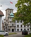
public building in the city of Solothurn, Switzerland  | |||||
| Upload media | |||||
| Instance of | |||||
|---|---|---|---|---|---|
| Part of | |||||
| Location | Solothurn, Solothurn District, Solothurn-Lebern, Solothurn, Switzerland | ||||
| Street address |
| ||||
| Heritage designation | |||||
 | |||||
Media in category "Rathaus (Solothurn)"
The following 42 files are in this category, out of 42 total.
-
 20170711 Solothurn 0680 (36539231460).jpg 5,760 × 3,840; 9.33 MB
-
 CH-NB - Solothurn, Rathaus, Fassade, vue partielle - Collection Max van Berchem - EAD-6927.tif 3,744 × 5,256; 18.79 MB
-

-
 CH-NB - Solothurn, Rathaus, vue partielle - Collection Max van Berchem - EAD-6928.tif 3,744 × 5,264; 18.82 MB
-
 CH-NB Photoglob-Wehrli EAD-WEHR-10792-B.tif 5,584 × 7,494, 2 pages; 79.88 MB
-
 Rathaus 01.JPG 3,264 × 2,448; 4.88 MB
-
 Rathaus 02.JPG 3,254 × 2,302; 3.8 MB
-
 Rathaus in Solothurn mit Fahne.jpg 2,379 × 3,233; 1.19 MB
-
 Rathaus in Solothurn.JPG 2,448 × 3,264; 4.29 MB
-
 Rathaus Kanton Solothurn 1.jpg 5,568 × 3,712; 7.87 MB
-
 Rathaus Kanton Solothurn 2.jpg 5,558 × 3,696; 8.66 MB
-
 Rathaus Solothurn (detail).jpg 2,048 × 1,536; 768 KB
-
 Rathaus Solothurn (door).jpg 2,048 × 1,536; 780 KB
-
 Rathaus Solothurn - 05-2019.jpg 3,500 × 4,200; 10.2 MB
-
 Rathaus Solothurn Tor.jpg 3,240 × 4,320; 1.78 MB
-
 Rathaus Solothurn.jpg 2,588 × 2,304; 821 KB
-
 Solothurn - Huis.jpg 3,024 × 4,032; 1.7 MB
-
 Solothurn - Rathaus - Detail.jpg 2,048 × 1,536; 632 KB
-
 Solothurn - Rathaus.jpg 1,176 × 2,015; 489 KB
-
 Solothurn - Uitzicht op toren.jpg 3,024 × 4,032; 1.67 MB
-
 Solothurn ingang.jpg 3,024 × 4,032; 2 MB
-
 Solothurn Rathaus.JPG 1,536 × 2,048; 387 KB
-
 Spiral staircase Rathaus Solothurn.jpg 4,160 × 3,120; 6.71 MB
-
 Zentralbibliothek Solothurn - Ansicht der Stadt Solothurn - aa0049.tiff 3,241 × 2,420; 22.46 MB
-
 Zentralbibliothek Solothurn - HÔTEL DE VILLE - a0050.tif 2,592 × 3,872; 28.74 MB
-
 Zentralbibliothek Solothurn - HÔTEL DE VILLE - a0581.tif 1,754 × 2,745; 13.8 MB
-
 Zentralbibliothek Solothurn - HÔTEL DE VILLE - a1078 05.tif 2,592 × 3,872; 28.74 MB
-
 Zentralbibliothek Solothurn - Lhôtel de ville de Soleure - a0585.tif 2,365 × 3,682; 24.94 MB
-

-
 Zentralbibliothek Solothurn - RUE DE LARSENAL - a0052.tif 2,592 × 3,872; 28.74 MB
-
 Zentralbibliothek Solothurn - RUE DE LARSENAL - a1078 04.tif 2,592 × 3,872; 28.74 MB
-
 Zentralbibliothek Solothurn - Solothurn Rue de lArsenal - a0053.tif 2,526 × 3,739; 27.04 MB
-
 Zentralbibliothek Solothurn Ernst Klöti 1156 Rathaus Solothurn.jpg 4,184 × 6,400; 19.16 MB
-
 Zentralbibliothek Solothurn Ernst Klöti 1157 Rathaus Solothurn.jpg 6,415 × 4,184; 18.24 MB
-
 Zentralbibliothek Solothurn Ernst Klöti 1159 Rathaus.jpg 6,415 × 4,184; 17.65 MB
-
 Zentralbibliothek Solothurn Ernst Klöti 1165 Rathaus.jpg 4,184 × 6,400; 16.53 MB
-
 Zentralbibliothek Solothurn Ernst Klöti 1183 Rathaus.jpg 6,415 × 4,184; 19.13 MB
-
 Zentralbibliothek Solothurn Ernst Klöti 1194 Rathaus.jpg 6,415 × 4,184; 19.25 MB
-
 Zentralbibliothek Solothurn Ernst Klöti 1195 Rathaus.jpg 4,184 × 6,400; 19.52 MB
-
 Zentralbibliothek Solothurn Ernst Klöti 1223 Rathaus.jpg 6,415 × 4,184; 17.8 MB
-
 Zentralbibliothek Solothurn Ernst Klöti 1226 Fratze Rathaus.jpg 4,184 × 6,400; 18.66 MB
-
 Zentralbibliothek Solothurn Ernst Klöti 1237 Rathausgasse.jpg 4,184 × 6,400; 17.23 MB
.jpg)


.jpg)
.jpg)


