Commons:Graphic Lab/Map workshop/Archive/2014
 | This is an archive of past discussions. Do not edit the contents of this page. If you wish to start a new discussion or revive an old one, please do so on the current talk page. |
Add heading for request here!
-
 Flag-map of the world

Article(s): ar:علم (راية)
Request:
- South Sudan is an independent country with a unique flag, since all countries are mentioned in the map, South Sudan should be mentioned --علاء الدين (talk) 15:53, 4 January 2014 (UTC)
Graphist opinion(s):
- As we are graphist doing the work and not people who knows everything it would be graet if you helped out with providing a map and a flag. In that way it will be done easier and faster. We (graphist) do not like to spend a lot of time searching for things or info, please provide it, thanks. --Goran tek-en (talk) 16:12, 4 January 2014 (UTC)
- The Flag of South Sudan is already shown. Nothing to do. NNW 18:53, 4 January 2014 (UTC)
- This section was archived on a request by: Goran tek-en (talk) 20:25, 13 January 2014 (UTC)
Districts of Damascus
-
 Districts of Damascus

Article(s): التقسيمات الإدارية في دمشق, on ar. wiki
Request:
- Can you please remove the English text and replace it with Arabic as follows:
- Dummar: دُمَّر
- Mazzeh: المزَّة
- Kafersouseh: كفرسوسة
- Al-Kadam: القدم
- Al-Yarmouk: اليرموك
- Al-Mydan: الميدان
- Al-Shaghour: الشَّاغور
- Al-Kanawat: القنوات
- Old City: دمشق القديمة
- Joubar: جوبر
- Saroujah: الساروجة
- Muhajreen: المهاجرين
- Al-Salheya: الصالحيَّة
- Rukun Eldin: رُكن الدّين
- Barzeh: برزة
- Al-Kaboun: القابون
Please can you use either "Tahoma" or "Simplified Arabic" (or Arial) Fornts? If you had any trouble with coping the names of the Districts (Some times spaces will appear), then just Make it a blank map and I'll add them my self. Thank you--باسم (talk) 13:55, 12 January 2014 (UTC)
Graphist opinion(s):
- I want to help but I'm in office now. I would suggest you to download Inkscape and try it yourself as a chance to familiarize with SVG editing. You just drag the GIF to Inkscape workspace and use path tool to trace the border of the districts. When you're done you remove the reference GIF and save as "plain SVG". It's not that difficult for such simple map. -- Sameboat - 同舟 (talk) 02:17, 13 January 2014 (UTC)
![]() Request taken by Goran tek-en (talk) 17:31, 13 January 2014 (UTC)
Request taken by Goran tek-en (talk) 17:31, 13 January 2014 (UTC)
I will make a svg file so it's easier to make language versions. --Goran tek-en (talk) 17:31, 13 January 2014 (UTC)
- Have a look at the two drafts arabic and english.
- You have to check all the areas as some were very hard to see and understand where they went and the spelling and placing for both languages. Any kind of feedback is welcome. --Goran tek-en (talk) 16:44, 14 January 2014 (UTC)
- Thanks guys, i used the Svg version and created this file--باسم (talk) 21:13, 14 January 2014 (UTC)
- To me that was not the optimal way to do it. The reason to have svg files is that it can be enlarged without any lost and it can be edited (e.a. different languages or other changes) in an easy way. I will upload them as svg also as that is to prefer over png but now there will be different versions which is confusion. You could just have asked me to change the size of the texts and remove the text background. --Goran tek-en (talk) 23:21, 14 January 2014 (UTC)
- Thanks guys, i used the Svg version and created this file--باسم (talk) 21:13, 14 January 2014 (UTC)
@باسم and باسم: I have now uploaded the two svg versions and edited the information for the gif and yours png files.
You had stated that yours png came from the gif file which isn't true, it came from my svg files. I tried to change all of that but didn't succeed totally so it would be good if you could have a look there. That is also a problem that arise when you take a DRAFT from my private website and use that before I have donated it to WMc. We won't get the flow or history of the versions correct.
Next time I would appreciate if you would wait until the real version is uploaded and not use a draft which actually is my property until I have uploaded it, thanks. --Goran tek-en (talk) 14:01, 15 January 2014 (UTC)
![]() Done
Done
- OK, thanks again--باسم (talk) 14:51, 15 January 2014 (UTC)
- This section was archived on a request by: Goran tek-en (talk) 14:01, 15 January 2014 (UTC)
Map of nahuatl speakers needs to be updated and/or improved
-
 Description of first image

Article(s): es:Náhuatl (and in all Wikipedias)
Request:
- It would be very useful to update this map based upon 2000 Census with 2010 data (you can find it there, checking "Habla indígena y lengua" and "Entidad y municipio", and then clicking on "Ver consulta" and then on the "+ Habla lengua indígena" and then on the "Página" 8 of the "columnas").
Moreover, it would be even more useful if it could look as the map of the page 5 of that document (but with 2010 data).
Maybe we may ask to Yavidaxiu who created File:Mapa de lenguas de México + 100 000.png, and/or Addicted04 who created this map. Ask me if I can help! --El Comandante (talk) 04:31, 14 January 2014 (UTC)
Graphist opinion(s):
- I will gladly help you and thank you for your explanation, it's great. But when I got that far I'm lost.
@El Comandante: I need your feedback as below if you want me to be able to complete your request, thanks. --Goran tek-en (talk) 16:32, 17 January 2014 (UTC)
- There is vertical column Náhuatl which I guess is the values. Then there is horizontal columns which I guess is different geographical areas. I don't know which of those to use and which that would be on the map, I have none such knowledge?
- If you can explain that to me I can do it otherwise you will have to wait for someone else. --Goran tek-en (talk) 15:15, 16 January 2014 (UTC)
- Thanks for your offer. I can't understand what do you misunderstand, so I copy for you here the numbers :
- Total 1,586,884
- Aguascalientes 391
- Baja California 2,978
- Baja California Sur 3,016
- Campeche 414
- Coahuila de Zaragoza 931
- Colima 1,427
- Chiapas 401
- Chihuahua 1,286
- Distrito Federal 33,796
- Durango 1,124
- Guanajuato 1,264
- Guerrero 170,622
- Hidalgo 245,153
- Jalisco 11,650
- México 61,670
- Michoacán de Ocampo 9,170
- Morelos 19,509
- Nayarit 1,904
- Nuevo León 21,723
- Oaxaca 11,690
- Puebla 447,797
- Querétaro 1,429
- Quintana Roo 1,310
- San Luis Potosí 141,326
- Sinaloa 2,136
- Sonora 2,004
- Tabasco 768
- Tamaulipas 10,029
- Tlaxcala 23,402
- Veracruz de Ignacio de la Llave 355,785
- Yucatán 276
- Zacatecas 503
- El Comandante (talk) 20:37, 17 January 2014 (UTC)
- Do you want me to point each state that needs a color changing in comparison with File:Nahuatl in Mexico.svg, or are you ready to check it by yourself? El Comandante (talk) 21:37, 17 January 2014 (UTC)
![]() Request taken by Goran tek-en (talk) 14:57, 18 January 2014 (UTC)
Request taken by Goran tek-en (talk) 14:57, 18 January 2014 (UTC)
- I don't understand why you have to be some annoyed about my questions. When you do graphic work like me we (wikigraphists) all the time have to deal with information in various forms and knowledge that we no nothing of. Often the information has to be picked out in a greater amount of information which is not all that easy all the time, and I don't speak Spanish so please beare with me.
- I thank you for your clarification and will soon be back with a draft for you to look at. --Goran tek-en (talk) 14:57, 18 January 2014 (UTC)
- I wasn't annoyed, and I don't understand why you suppose that ; surely some cultural gap of expression between french and sweden people. Moreover, I can't express myself fluently in english, it's difficult for me.
- Sorry for the confusion.
- El Comandante (talk) 16:06, 19 January 2014 (UTC)
- I don't understand why you have to be some annoyed about my questions. When you do graphic work like me we (wikigraphists) all the time have to deal with information in various forms and knowledge that we no nothing of. Often the information has to be picked out in a greater amount of information which is not all that easy all the time, and I don't speak Spanish so please beare with me.
When I check on that page in the pdf and compare it to your list above only Puebla is on the pdf-page.
I don't have any knowledge where any of the other areas are located or what its area looks like so I need your assistance for that? --Goran tek-en (talk) 15:42, 18 January 2014 (UTC)
- There is a confusion, because Puebla is the name of a Mexican state, but also the name of the state's capital. The page 5 of the pdf shows a map of Nahuatl speakers by municipalidades (municipalities) while the map File:Nahuatl in Mexico.svg shows Nahuatl speakers by Estados (mexican states). As the 2010 data copied here only concerns Estados, it is useful to update the map File:Nahuatl in Mexico.svg, but not to create a new map of all the municipalidades where more than 1000 Nahuatl speakers live.
- To update the map File:Nahuatl in Mexico.svg, you need to check where each state is located (using for example this other map : File:Blank map of Mexico with states names.svg) and to what bracket it belongs (less than 1000 Nahuatl speakers, between 1000 and 10000, etc.).
- I won't ask you to create a map similar to the one in the pdf, because it would be far much too tedious for someone who doesn't know very well Mexico's geography (there are more than 200 municipalidades with more than 1000 Nahuatl speakers). Maybe Yavidaxiu and/or Addicted04 could do it, but even for them it would be tedious.
- I thank you one more time for your help.
- El Comandante (talk) 16:06, 19 January 2014 (UTC)
- Thanks now I understand.
- It was your final writing before "or are you ready to check it by yourself?" that I thought was some indication of irritation. I'm really really sorry for that misunderstanding. Your are very good at explaining but I didn't understand that the two maps showed different things, municipals/states so I couldn't get how to join them but now I do. Ones you mentioned the map with states and the fact with the difference I understood. Thanks again and I will be back soon with a draft for you. --Goran tek-en (talk) 18:44, 19 January 2014 (UTC)
- @El Comandante: Now you can look at a draft here and then give me feedback on it thanks. --Goran tek-en (talk) 16:53, 20 January 2014 (UTC)
- @Goran tek-en: Thank you very much for your work. I've checked if there's no error in each state's color, and everything seems correct. If I may be allowed to make a suggestion, maybe it would be better to chose another map coloring : I'm not a map designer, but I feel like the shading of the original map designed by DavoO aka Addicted04 is more readable (and aesthetic, but that's very subjective). El Comandante (talk) 12:35, 22 January 2014 (UTC)
- @El Comandante: I have changed the colors now and you can have a look at the new draft here, maybe you will have to reload the page to get the new image.
- *So if I understand you right you will check it and then get back to me before I upload it.
- *You should also tell me if you want me to upload it as a new image and if so give me category/ies, descripton, filename, thanks. --Goran tek-en (talk) 13:38, 22 January 2014 (UTC)
- @Goran tek-en: Thank you one more time.
- I'm sorry to criticize your hard work but, by myself, I wouldn't have chosen different colors, but different tones of one color, as in the original map, because the result, with different colors, is more difficult to comprehend : in a glance, with the original map, you can see where most of Nahuatl speakers live in Mexico, and that's not possible with different colors. By the way, you offered a lot of your time to make this map, so I won't insist on another color changing.
- To upload it, I would chose the name Nahuatl speakers in Mexico in 2010. For the categories, I would chose the same as the original map (Category:Linguistic maps of Native American languages, Category:Linguistic maps of Mexico and Category:Maps of Nahuatl speakers). For the description I would write :
- @Goran tek-en: Thank you one more time.
- @El Comandante: I have changed the colors now and you can have a look at the new draft here, maybe you will have to reload the page to get the new image.
- @Goran tek-en: Thank you very much for your work. I've checked if there's no error in each state's color, and everything seems correct. If I may be allowed to make a suggestion, maybe it would be better to chose another map coloring : I'm not a map designer, but I feel like the shading of the original map designed by DavoO aka Addicted04 is more readable (and aesthetic, but that's very subjective). El Comandante (talk) 12:35, 22 January 2014 (UTC)
- @El Comandante: Now you can look at a draft here and then give me feedback on it thanks. --Goran tek-en (talk) 16:53, 20 January 2014 (UTC)
- Thanks now I understand.
| Description |
English: Map about number of speakers of nahuatl in Mexico in 2010 according to the XIII Censo General de Población y Vivienda of the INEGI
Español: Mapa acerca del número de hablantes del náhuatl en México, según el XIII Censo General de Población y Vivienda del INEGI en 2010 Français : Carte du nombre de locuteurs du nahuatl au Mexique, par État, selon le recensement de 2010 de l'INEGI. |
| Date | |
| Source | INEGI : Censo de Población y Vivienda 2010 (click on "Habla indígena y lengua" and "Entidad y municipio", and then on "Ver consulta" below and then on the "+ Habla lengua indígena" on top and then on the "Página" 8 of the "columnas", on the right top). |
| Author | Goran tek-en |
| Other versions |
|
@El Comandante: It's not criticism but feedback. You are the requester and to a very big degree it's up to you how it should look. There is a limit somewhere of what I will do/change but this is far from that limit. I don't agree totally with you but that's another point and not very important in this matter. I have more steps than the previous one and there fore it's harder to use tones of the same color because you still want them to be separate visible colors, Not everyone has a screen that can show every tone so for them it might be harder to see the differences like this.
I thank you for all the information you provided for the upload, it's great like that.
I did change according to your likes and you can find the image here Nahuatl speakers in Mexico in 2010.svg. If there is anything you would like to change just contact me, thanks. --Goran tek-en (talk) 22:52, 22 January 2014 (UTC)
- That's great, thank you very much, you rock! El Comandante (talk) 06:08, 23 January 2014 (UTC)
![]() Done
Done
- This section was archived on a request by: Goran tek-en (talk) 22:52, 22 January 2014 (UTC)
Lakes colored like countries
- This section was archived on a request by: Nyttend (talk) 02:59, 1 February 2014 (UTC)
-
 Map of Europe with different COM:FOP statuses

Article(s): Fourteen pages here, and thirteen at various Wikipedias, plus one at the German Wikivoyage.
Request:
- Four lakes (two in southern Sweden, and two in northwestern Russia) are miscolored: they have approximately the color of the "OK" countries. Please change them so they're transparent like the oceans and the Black Sea. --Nyttend (talk) 01:14, 26 January 2014 (UTC)
Graphist opinion(s):
![]() Done -- Fulvio 314 10:53, 30 January 2014 (UTC)
Done -- Fulvio 314 10:53, 30 January 2014 (UTC)
- Thanks! Nyttend (talk) 02:59, 1 February 2014 (UTC)
Briarcliff Manor Map
-
 Location of Briarcliff Manor within Westchester County and the county within New York.

Article(s): en:User:Ɱ/sandbox7 (a draft to replace en:Briarcliff Manor, New York)
Request:
- I made this as image using some existing maps, and initially was able to remove all of the background on Photoshop. I then decided to vectorize the image to an SVG, but the white background returned. I removed most of it again, as can be seen. I don't know how to remove the rest of it, and I've tried on Photoshop and Illustrator (CS6), Gimp, and Inkscape. Either I don't have enough technical knowledge of the softwares or perhaps I should try another freeware vector editor. Could someone either instruct me how to fix the background on one or more of those programs, or (preferred) go ahead and remove it? I can provide the original PNG or SVG files, if that helps. Thanks so much. --Ɱ (talk) 18:03, 14 February 2014 (UTC)
Graphist opinion(s):
- I have uploaded a new version where I removed the white in the left part, was that what you meant? If you check pretty soon you will have to download and look at it as the image on the its page could take some time to update. Get back to me if it's something else, thanks. --Goran tek-en (talk) 18:41, 14 February 2014 (UTC)
![]() Done:This section was archived on a request by: Goran tek-en (talk) 18:41, 14 February 2014 (UTC)
Done:This section was archived on a request by: Goran tek-en (talk) 18:41, 14 February 2014 (UTC)
- Thanks so much for the quick work! Tell me though, how did you do it? I've been trying to fix that myself for hours. --Ɱ (talk) 18:48, 14 February 2014 (UTC)
- I work in Inkscape. The white was a filled area and under it was a grey area. I selected the white and the grey area then in menu used Path/Difference. This removes the same area as the white (top object) in the grey area. I don't remember if I had to Ungroup or Break a part the grey. Sometimes you have to do this to have just one object. --Goran tek-en (talk) 19:37, 14 February 2014 (UTC)
- As I suspected, the solution is way above me. I don't have nearly the amount of knowledge or experience to do that, nonetheless know to do that. Thank you again! --ɱ (talk) 19:55, 14 February 2014 (UTC)
- I work in Inkscape. The white was a filled area and under it was a grey area. I selected the white and the grey area then in menu used Path/Difference. This removes the same area as the white (top object) in the grey area. I don't remember if I had to Ungroup or Break a part the grey. Sometimes you have to do this to have just one object. --Goran tek-en (talk) 19:37, 14 February 2014 (UTC)
- Thanks so much for the quick work! Tell me though, how did you do it? I've been trying to fix that myself for hours. --Ɱ (talk) 18:48, 14 February 2014 (UTC)
Help needed to fix BlankMap-FlatWorld6.svg
-
 This is the basic blank map
 -
 Sudan is supposed to be red, too


Request:
- This map is one of the most used blank maps of the world, but it may need to be fixed. I edited this map in a text editor as explained in the instructions here and mostly it worked well, but Sudan remains grey even though I have added the right country code. Probably something went wrong when South Sudan was added.--Underlying lk (talk) 14:24, 2 March 2014 (UTC)
Graphist opinion(s):
 Request taken by Goran tek-en (talk) 16:06, 9 March 2014 (UTC)
![]() Done New version uploaded, it can take some time for the preview to update.
Done New version uploaded, it can take some time for the preview to update.
- This section was archived on a request by: Goran tek-en (talk) 16:06, 9 March 2014 (UTC)
adjust border of Basque dialects
-
 Basque dialects
 -
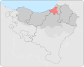 Lapurdian dialect
 -
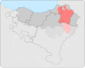 Lower Navarrese dialect


Article(s): en:Basque language
Request:
- Could the boundary between the Lapurdian and Lower Navarrese dialects (pink and brown in the first map) be adjusted away from the modern political boundaries to match the dialectical boundaries in our sources? Examples of the latter are File:BonaparteEuskara.gif (orange–lavender border), or as interpreted at File:Euskal Herria euskalkiak2.svg (orange–brown border) or, as a last resort, the really simplified File:Basque Dialectes.svg (yellow–blue border). --Kwamikagami (talk) 23:28, 14 February 2014 (UTC)
I'm no longer using the latter two maps, but if we correct one, IMO we should correct them all, since they're part of a series. Kwamikagami (talk) 05:44, 22 February 2014 (UTC)
Graphist opinion(s):
- Request taken by Goran tek-en (talk) 16:40, 9 March 2014 (UTC)
- Kwamikagami Now you can look at the drafts here;
- The maps were made in a way that wasn't so good for editing and other things (to me at least). I have remade them so I want you to really check them so I haven't made any mistakes. Give me then feedback on them, thanks.--Goran tek-en (talk) 17:12, 11 March 2014 (UTC)
- They look excellent, with one exception: The northern border (of the pink and brown) is not the political border, but has receded under the influence of French, so the original extent in that direction should be retained. That is, I was hoping to have just the boundary between pink and brown dialects adjusted, not the overall extent of the language. The rest looks good. Kwamikagami (talk) 08:33, 12 March 2014 (UTC)
- Look at this new one and reload the page, is this OK now?
- But then I don't understand as the other two has the same north border, should they not also be corrected? --Goran tek-en (talk) 19:17, 13 March 2014 (UTC)
- Perfect! Yes, they should all have the same border. Kwamikagami (talk) 09:19, 14 March 2014 (UTC)
- They look excellent, with one exception: The northern border (of the pink and brown) is not the political border, but has receded under the influence of French, so the original extent in that direction should be retained. That is, I was hoping to have just the boundary between pink and brown dialects adjusted, not the overall extent of the language. The rest looks good. Kwamikagami (talk) 08:33, 12 March 2014 (UTC)
![]() Done Now they are uploaded as versions. --Goran tek-en (talk) 19:05, 14 March 2014 (UTC)
Done Now they are uploaded as versions. --Goran tek-en (talk) 19:05, 14 March 2014 (UTC)
- This section was archived on a request by: Goran tek-en (talk) 19:05, 14 March 2014 (UTC)
Dead sea ecological disaster, Arabic
-
 Dead sea ecological disaster

Article(s): البحر الميت
Request:
- Can you keep this image in it original format (i mean to keep it a moving photo) but translate the names of the locations and the titles to Arabic? The translation is as follows:
- Dead sea Ecological disaster: كارثة زوال البحر الميت
- Kalia: عين قالية
- Mineral Beach: شاطئ الينابيع المعدنية
- dargot: دارغوت
- Ain-Gidi: عين جدي
- Metzad: متزاد
- Ein Bokek: عين بوكك
- Mount Sodom: جبل السدوم
Thank you--باسم (talk) 12:10, 11 March 2014 (UTC)
Graphist opinion(s):
- Request taken by Goran tek-en (talk) 19:10, 17 March 2014 (UTC)
- باسم Now you can look at this draft and give me feedback on it. Should not the years also be translated? --Goran tek-en (talk) 16:23, 20 March 2014 (UTC)
- Goran tek-en its correct, thank you very much :-)باسم (talk) 16:42, 20 March 2014 (UTC)
- باسم Now you can look at this draft and give me feedback on it. Should not the years also be translated? --Goran tek-en (talk) 16:23, 20 March 2014 (UTC)
Now you can find it here Dead sea ecological disaster 1960 - 2007 arabic. --Goran tek-en (talk) 18:50, 20 March 2014 (UTC)
![]() Done:This section was archived on a request by: Goran tek-en (talk) 18:50, 20 March 2014 (UTC)
Done:This section was archived on a request by: Goran tek-en (talk) 18:50, 20 March 2014 (UTC)
Central europe 1683.png into SVG?
-
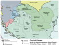 Central Europe in 1683

Article(s): es:Historia de Hungría, es:Paz de Karlowitz, es:Emérico Thököly, es:Acuerdo de Speyer, es:Principado de Transilvania, es:Estados vasallos y tributarios del Imperio otomano, es:Principados del Danubio, es:Hungría otomana
Request:
- I wonder if someone could turn the above map into SVG. It seems to be widely used and I would like to translate it into Spanish, but I would rather do so when it is in SVG format. I would be grateful if someone could take the time to make the SVG version.--Rowanwindwhistler (talk) 19:03, 18 March 2014 (UTC)
Graphist opinion(s):
- Request taken by Goran tek-en (talk) 16:29, 22 March 2014 (UTC)
- Rowanwindwhistler Now there is a draft for you to look at and give me feedback on.
- You should really look at the spelling and the special letters, I'm not sure I got them right. Get back to me. --Goran tek-en (talk) 19:38, 27 March 2014 (UTC)
- Rowanwindwhistler Now there is a draft for you to look at and give me feedback on.
- It looks excellent, Goran tek-en! I just see some typos that may need very small corrections: RUMELIA AYALET instead of RUMELIA EYALET, TEMEŞVAR is missing (the city, not the region), Habsburg Monarchy of Hungary (Royal Hungary) should say Habsburg Kingdom of Hungary (Royal Hungary) to match the original map. I think that is really all... Thank you indeed for your great work!--Rowanwindwhistler (talk) 21:09, 27 March 2014 (UTC)
- Having prepared this high quality image, one should reconsider the name of the map which is misleading now. As it doesn't show "Central Europe" but more likely the "Vassal States of the Ottoman Empire" or the the "Danubian States" or some other named group of countries, it is the right time for a new name that should be more precise. --Maxxl2 - talk 21:22, 27 March 2014 (UTC)
- I think the name is correct though it could possibly be improved to make it even more precise. Anyhow I consider it a secondary matter, to be agreed with the author of the original map. The goal was to get the map in SVG for easy translation and I would say we have an excellent result.--Rowanwindwhistler (talk) 05:28, 28 March 2014 (UTC)
Maxxl2Rowanwindwhistler I was just about to upload it, but I will hold, and I think this is REALLY the time to consider the name. It's always extra work to change it later.
I will give you guys a couple of days to decide and then you could provide me with all of this;
- Name of the file
- Description
- Category/ies
Give me the info I need, thanks. --Goran tek-en (talk) 19:36, 28 March 2014 (UTC)
- As far as I am concerned, I would keep the values from the original file. Thank you.--Rowanwindwhistler (talk) 21:37, 28 March 2014 (UTC)
- Rowanwindwhistler But the name can't be the same, "Central europe 1683.*". It has to be different so maybe "Central europe 1683_english.svg" or what you tell me. --Goran tek-en (talk) 19:04, 29 March 2014 (UTC)
- I suggest to name it "Vassal states of the Ottoman Empire in 1683". That is what the caption says in the en-wp. That is the description aswell and the cotegories should be same as with the PNG version. --Maxxl2 - talk 19:15, 29 March 2014 (UTC)
Now it's uploaded Vassal states of the Ottoman Empire in 1683. If there is anything you want me to change or so just contact me. --Goran tek-en (talk) 19:58, 29 March 2014 (UTC)
![]() Done:This section was archived on a request by: Goran tek-en (talk) 19:58, 29 March 2014 (UTC)
Done:This section was archived on a request by: Goran tek-en (talk) 19:58, 29 March 2014 (UTC)
Replacement needed
Article(s): many wikis
Request:
- Hello map-wizards! Is there any chance to create a new map NOT based on this one? The license is not correct, PD-status is in question. We could use a good replacement. --Hedwig in Washington (mail?) 03:50, 28 March 2014 (UTC)
Graphist opinion(s):
- Replaced map, no work needed. --Hedwig in Washington (mail?) 00:54, 14 April 2014 (UTC)
- This section was archived on a request by: Hedwig in Washington (mail?) 00:54, 14 April 2014 (UTC)
Strange glitch in file
Request:
When I edit File:Congo 1961 map en.svg in inkscape it looks just fine, but when I upload it, a little black line appears behind the words "Government of Gizenga". I can't figure out why. Can anyone help? Thanks! - Themightyquill (talk) 10:40, 3 April 2014 (UTC)
- Please read this. Good luck. --Maxxl2 - talk 11:38, 3 April 2014 (UTC)
Thanks Maxx12. That seems like a reasonable explanation, but I followed the steps and the problem was not resolved. I moved the text up, but the black line remains where it was. I guess it's possible that there's still a blank textbox there, but I can't seem to find it in the xml. Any other suggestions? Thanks! - Themightyquill (talk) 11:23, 4 April 2014 (UTC)
- I should mention as well, that when I click the file on wikipedia so I've viewing the svg file directly, there is no line. It's only in the wikimedia render of the image. - Themightyquill (talk) 11:24, 4 April 2014 (UTC)
 Done Flowroot element found and deleted. --Maxxl2 - talk 11:41, 4 April 2014 (UTC)
- This section was archived on a request by: Maxxl2 - talk 09:11, 18 April 2014 (UTC)
Mauryan Empire Map.gif into SVG
-
 Map of the Mauryan Empire
 -
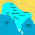 SVG version


Article(s): es:Imperio kushán, es:Imperio Maurya, es:Historia de Pakistán, es:Bindusara, es:Anexo:Estados de la Antigüedad
Request:
- I wonder if someone could turn the above map into SVG. My goal is to translate such a map into Spanish for the Spanish Wikipedia and also to use it as a base to turn the related maps in the same category into SVG. Thank you.--Rowanwindwhistler (talk) 06:51, 18 April 2014 (UTC)
Graphist opinion(s):
- Request taken by Maxxl2 - talk 09:40, 18 April 2014 (UTC)
- Done --Maxxl2 - talk 13:12, 18 April 2014 (UTC)
- Excellent!! Thank you!--Rowanwindwhistler (talk) 21:02, 18 April 2014 (UTC)
- This section was archived on a request by: Rowanwindwhistler (talk) 21:02, 18 April 2014 (UTC)
Help needed with a multilingual map
-
 File with multiple translations
Article(s): en:Condorcet method
Request:
- I added Ukrainian translation for this file using the
<switch>element but somehow it doesn't work when I change language to Ukrainian. Any help would be appreciated. --DixonD (talk) 19:52, 28 May 2014 (UTC)- Done Never mind, it turns out that you need to put the default option in switch in the end. --DixonD (talk) 19:58, 28 May 2014 (UTC)
Graphist opinion(s):
- The "switch" element works as follows: once it finds a suitable element at the next level, it uses that and stops looking for any more. Hence it was using the English (which was first) and not the Ukrainian. I just switched them around and it's working now. :) NikNaks talk - gallery - wikipedia 19:59, 28 May 2014 (UTC)
- You found out yourself. :P Anyway, the more you know! NikNaks talk - gallery - wikipedia 19:59, 28 May 2014 (UTC)
- Thanks anyway:) --DixonD (talk) 20:03, 28 May 2014 (UTC)
- You found out yourself. :P Anyway, the more you know! NikNaks talk - gallery - wikipedia 19:59, 28 May 2014 (UTC)
- This section was archived on a request by: NikNaks talk - gallery - wikipedia 20:15, 28 May 2014 (UTC)
Add heading for request here!
-
 Map of DEA Field Divisions (outdated)
 -
 My attempt


Article(s):zh:美国缉毒局 & en:Drug Enforcement Administration to replace. Add to other language Wikis.
Request:
- 1) The map linked above is out of date by a bit. A more modern, updated map is on the Justice Department's website. Both maps are PD-USGov, but both are of poor quality. I'm hoping one of you skilled volunteers can make a US map with the DEA divisions properly included from the Justice Department source. Thanks in advance for your consideration. TLSuda (talk) 02:18, 30 May 2014 (UTC)
- @Goran tek-en: I tried it myself, see above, but it didn't turn out so well. Maybe you can do much better? TLSuda (talk) 01:47, 24 June 2014 (UTC)
Graphist opinion(s):
- Request taken by Goran tek-en (talk) 18:22, 23 June 2014 (UTC)
- It's hard to do a map that works for all different occasions and in every size, it's really impossible. It all depends on how it's going to be used, the purpose, how to expose it and what the viewer is using to view it etc. I don't know any of this really so I have made a draft that works in 100% or larger, also smaller to some degree. It's transparent in the background at this time but maybe there should be a background color. Also I did put in the names instead of having a separate legend. Very often I prefer this if it's possible. It's made as a svg image so it can be easier to edit in the future and to enlarge if needed.
- A draft to give feedback on --Goran tek-en (talk) 17:52, 24 June 2014 (UTC)
- @Goran tek-en: Oh my! That's absolutely fantastic! Let me know when you upload it, I'd like to use it in a bunch of places. Cheers, TLSuda (talk) 15:02, 28 June 2014 (UTC)
- TLSuda Now you can find it here Drug Enforcement Administration.
- If you don't want your version to be used then you should put it up for removal. --Goran tek-en (talk) 20:05, 29 June 2014 (UTC)
- TLSuda Now you can find it here Drug Enforcement Administration.
- @Goran tek-en: Oh my! That's absolutely fantastic! Let me know when you upload it, I'd like to use it in a bunch of places. Cheers, TLSuda (talk) 15:02, 28 June 2014 (UTC)
![]() Done
Done
- This section was archived on a request by: Goran tek-en (talk) 20:05, 29 June 2014 (UTC)
Idrisids-eng.PNG into SVG for easy translation
-
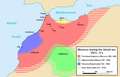 Map of Morocco during the idrissid era.
 -
 Vectori image outline

.svg)
Article(s): es:Sijilmasa
Request:
- I would be grateful if someone could turn the above map into SVG. My goal is to translate the SVG into Spanish for use in the Spanish Wikipedia (in one article so far, probably more in the future).--Rowanwindwhistler (talk) 14:22, 4 July 2014 (UTC)
Graphist opinion(s): I'm sorry Rowanwindwhistler but I have to withdraw my Taken. I have run into some private problems. --Goran tek-en (talk) 14:02, 9 July 2014 (UTC)
- No problem at all, thank you indeed for volunteering anyhow!--Rowanwindwhistler (talk) 16:03, 9 July 2014 (UTC)
- Rowanwindwhistler Hi!, I tried to help you creating the vector version of this map. I learned just few days ago to use Inkscape so I'm not very good but I think it coul fit. The colors are little more vivid. Let me know if there is something wrong --Nastoshka (talk) 18:01, 9 July 2014 (UTC)
- Thank you for the map!! I have made a few changes based on it (putting each territory into its own layer, changing the colours and the font and joining together some objects) but it is just what I needed. I will be uploading the Spanish version in a moment now. I think we can consider it solved. Many thanks for the effort!--Rowanwindwhistler (talk) 20:33, 9 July 2014 (UTC)
- Ok No problem. I'm going to upload a new version with the same colors also for the english version.
- Thank you for the map!! I have made a few changes based on it (putting each territory into its own layer, changing the colours and the font and joining together some objects) but it is just what I needed. I will be uploading the Spanish version in a moment now. I think we can consider it solved. Many thanks for the effort!--Rowanwindwhistler (talk) 20:33, 9 July 2014 (UTC)
![]() Done
Done
- This section was archived on a request by: Nastoshka (talk) 22:51, 9 July 2014 (UTC)
Syntax validation of Historical map of algeria.svg
-
 9th century Algeria

Article(s): es:Rostomitas
Request:
- Hello, I was trying to upload a Spanish translation of the above map but the upload wizard claims it is corrupted. As I just removed some apparently layers and changed the text I suspect the corruption was already there in the above version. Could someone let me know if the map is indeed corrupt or if we have some validation tool for SVG that tell me what is wrong? I am sorry if this is not the right place to ask, I am not 100% sure...--Rowanwindwhistler (talk) 07:20, 11 July 2014 (UTC)
Graphist opinion(s):
- I've cleaned the code. Please try again. -- Maxxl² - talk 09:41, 11 July 2014 (UTC)
- Excellent, thank you! The new map works and I could upload the new Spanish version. Many thanks for your help--Rowanwindwhistler (talk) 10:03, 11 July 2014 (UTC)
- This section was archived on a request by: Maxxl² - talk 10:17, 11 July 2014 (UTC)
South Russia travel maps
- This section was archived on a request by: Nastoshka (talk) 07:54, 18 July 2014 (UTC)
-
 Southern Russia
 -
 New version


voy:Southern Russia and all the other voy linguistic versions
Request:
- Hi, If I do not disturb, I'd like to request an update of this map in order to include also the Crimean Peninsula, now included in all wikivoyage articles about Southern Russia. It should not take much time. We have a larger map from which you should be able to derive the new map with Crimea. Both files are svg verions, so you already have colours, keys and labels. The only missing labels are those of Crimea. Once we have the new svg map it will be easy to update also the png maps --Nastoshka (talk) 12:17, 6 July 2014 (UTC)
Graphist opinion(s):
- Done Hellerick (talk) 02:48, 18 July 2014 (UTC)
- My congratulations. Very nice work! I've just added the italian labels into a further level. Thanks!--Nastoshka (talk) 07:54, 18 July 2014 (UTC)
- This section was archived on a request by: Nastoshka (talk) 07:54, 18 July 2014 (UTC)
Maps of regions of Belgium
Note: This request was moved from the Images to improve or create to the Map workshop. Ivan Akira (talk) 02:08, 18 December 2009 (UTC)
-
Map of Brussels
-
 Map of Flanders
 -
 Blank map


Request: There is an error on those maps. It seems that the creator has placed the municipality of Jette in Flanders, while it belongs to Brussels. Thank you for your help. BrightRaven (talk) 10:07, 4 November 2009 (UTC)
Graphist opinion(s): ![]() Comment Seems that the first two have been superseded by: File:Brussels-Capital Region (Belgium) location.svg and File:Flanders (Belgium) location.svg. --ELEKHHT 23:08, 8 June 2011 (UTC)
Comment Seems that the first two have been superseded by: File:Brussels-Capital Region (Belgium) location.svg and File:Flanders (Belgium) location.svg. --ELEKHHT 23:08, 8 June 2011 (UTC)
SVG fills - surely there's a better way!
Note: This request was moved from the Images to improve or create to the Map workshop. Ivan Akira (talk) 02:08, 18 December 2009 (UTC)
-
 New file
 -
 Original


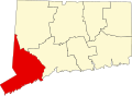
Request: I duplicated the <use xlink:href="#Fairfield" stroke="none" fill="red"/> line with all county names (e.g. New_Haven) and changed the fill to gold. Is there a better way? Guy0307 (talk) 07:23, 9 November 2009 (UTC)
Graphist opinion:
- xlink:href="#Fairfield" creates a clone of the Fairfield object above the original one. Instead of doing this you can simply change the colour of the original object by going to <path id="Fairfield" d="M -6382... and changing it to <path id="Fairfield" fill="red" d="M -6382.... Alternatively if you want to colour all of the counties go to <g stroke="black" fill="none" and change "none" to red. /129.215.149.96 13:33, 25 November 2009 (UTC)
Armenian Genocide

Request: Straighten and fix shading... --Kintetsubuffalo (talk) 06:52, 21 March 2010 (UTC)
Graphist opinion(s): Straightening (warping) will always make you lose data, which manifests as blurriness. Best course of action is to scan as straight as possible from the start. If it's not possible in one go, try to take multiple scans so that ultimately every area is as level with the scanbed as possible. You'll possibly lose some data in the masking too, but it's better than to twist the images. If you still wish to simply straighten the image, I can do that, but if you can scan as stated previously, send me the TIFF's and I can puzzle it together. --Chrishelenius (talk) 17:39, 28 August 2012 (UTC)
Winkel-Tripel coordinate plots
Unusual request: technology development rather than image development.
Request: I'm working on a weather extension using 1200x600 and 800x400 Winkel III projection maps, and need to plot lat/lon coordinates on the images (to display weather icons.) The ultimate goal is to improve upon C/F-style templates which are vulnerable to volunteer participation and require regular bot edits. But at the moment I'm stymied plotting the coordinates. Can the Graphics Lab/Mappers help out with this project? - Amgine (talk) 03:29, 23 November 2010 (UTC)
Graphist opinion(s): Is hard-coding a look-up table for {long/lat}<->{x,y} an acceptable solution? Jon C (talk) 06:09, 28 December 2010 (UTC)
English-language map of Holy Roman Empire at 1789
-
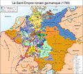
 English-language map of the Holy Roman Empire, as at 1789
 -
 German-language original
 -
 French-language copy


Request: I have added a list of terms for translation on the Talk: page for the English-language image; could someone convert the English-language map to SVG and please apply these translations? OwenBlacker | Discussion 22:11, 2 December 2010 (UTC)
Graphist opinion(s): The map cannot be easily vectorized because of its complexity and need for accuracy. If you have access to the original vector file -- or equivalent in other languages -- the translations themselves would be easy. Jon C (talk) 06:00, 28 December 2010 (UTC)
Graphist opinion:
Morocco-Ottoman Empire relations
-
 Original map
 -
 Saadi Morocco borders
 -
 SVG exemplar


Request: Please somebody fix the Moroccan borders. ... Flad (talk) 13:53, 10 December 2010 (UTC)
Graphist opinion: Are you sure that the border of Morocco was that border at that time. The border of the current dinasty has changed a lot throughout its history reaching its peak from 1860-1890 being smaller than its current border before hand and then partitioned by colonial powers. so, what I'm getting at here is: was the border like that at that pericular time or only during that dynasty's peak which in it self could have been any time during its existence. Also, I have to make sure the Ottoman Empire's extent was currect to the time. The English Wiki page that uses it says the 6-17 centuries however the actual file does not specify any perticular period. (sorry for being picky!) Maps & Lucy (talk) 00:00, 20 December 2010 (UTC)
- Here's a map of the borders in 1600 (Morocco during Saadi dynasty) and 1700 (Morocco during Alaouite and current dynasty), hope it would help :) --Flad (talk) 01:44, 18 January 2011 (UTC)
Portugal (orthographic projection)
-
 The image to be changed
.svg)
-
 One image of the "whole" country of Portugal
 -
 The real distance of Azores and Madeira (Azores is on top)
 -
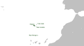 Real distance of Madeira
 -
 An example of what I want
 -
 Another example ;)


.png)
.svg)
Request: The orthoghaphic projection map of Portugal only shows the continental part of the country. Azores and Madeira (who are also part of the country) are not in the map. Someone could please include the two archipelagos in the same way they did wht the Canary Islands of Spain (with a "zoon" in the islands to really show then) and include in the map? Thanks in advance. Béria Lima msg 16:49, 17 January 2011 (UTC)
Graphist opinion(s):
- This image is clearly intended for the infobox in the country's main article. I prefer the Europe map version which is uniform across all EU member states' articles (as well as for non-EU European countries). The globe view is less suited due to the relatively small land area of European countries - Ssolbergj (talk) 21:20, 17 January 2011 (UTC)
- the image of the Canary Island have the same "European" background. And i don't Azores or Madeira to be the "star" of the picture, but since they are part of the country (are not colonies, are not independent - they are actually part of Portugal) they need to be in the map, in order to get the right map in the article. Béria Lima msg 18:22, 22 January 2011 (UTC)
- This image is clearly intended for the infobox in the country's main article. I prefer the Europe map version which is uniform across all EU member states' articles (as well as for non-EU European countries). The globe view is less suited due to the relatively small land area of European countries - Ssolbergj (talk) 21:20, 17 January 2011 (UTC)
Y Haplogroups distribution in the world

Request: It's about the Y Haplogroups distribution in the world, can anybody create a map based on the data of this genetic reaserch? --WorldHaplogroupsMaps.pdf (first page) Cheers. --Flad (talk) 14:11, 23 February 2011 (UTC)
Graphist opinion(s): You would have to be much more specific. The pdf holds A LOT of information and different maps. It's impossible for us to get the needed information out of this. You will have to do that job. --Goran tek-en (talk) 19:34, 12 January 2014 (UTC)
XYZ Line
Request:
- I would like to convert both images into .svg, although whith a little modifications. In the map Líneas Defensivas de Valencia I would like to change the colour of the red lines (defensives lines), to be more easy differentiate it. Also, I would like to delete the numbers that appears into the lines. To finish, I would want a second version of this map in .svg, but only appearing the XYZ Line. Thanks --Manuchansu (talk) 12:05, 25 March 2011 (UTC)
Graphist opinion(s):
- Where are the maps? --Robot8A (talk) 09:41, 25 August 2011 (UTC)
South Sudan
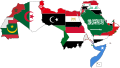
Request: Literally hundreds of maps relating to the world's newest country, South Sudan. Country maps, maps of neighboring countries, Africa maps, hemisphere maps, Arab league maps, multinational organization maps. The number would I am afraid overwhelm the machinery of this page and some of the issues are still outstanding (status of Abyei Province, membership in Arab League, Commonwealth, UN, etc.) As much as new maps and categories we may need a new tracking/organization procedure. Should I start a subpage for request, organize most used/most needed - or just dump it all here? Rmhermen (talk) 15:43, 9 July 2011 (UTC)
- As I mentionned here [1], just for the Arab League (Category:Arab_League) it will be a long job. Let's begin by most used-most needed. Here is what we need in ar wikipedia to be updated.
-

-

-
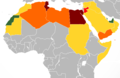 2010-2011-Arab-World-Protests
 -

-

-
.svg)


Graphist opinion(s): Just wanted to point out that new versions of files should in most cases not be uploaded over the old versions, which may be useful for historical purposes. — Cheers, JackLee –talk– 17:45, 9 July 2011 (UTC)
- Especially not that "Arab Uprisings" map, which is explicitly an historical document. Powers (talk) 20:51, 11 July 2011 (UTC)
Requested edit can someone add it here--File:UN Member Countries World.svg? Is there any centralized effort to add South Sudan to maps? Koavf (talk) 21:16, 14 July 2011 (UTC)
- There is now a Category:Maps needing South Sudan political boundaries; feel free to tag any maps that need updating or look into it if you'd like to help update maps. If a map shouldn't be overwritten by the new file, just add something like {{warning|Please upload the updated version separately.}} at the top. -MissMJ (talk) 21:32, 14 July 2011 (UTC)
Nazi party rally grounds
-
 Map of en:Nazi party rally grounds in 1940

Request: Please make a version in the English language; that version will be used on EN WhisperToMe (talk) 07:54, 15 July 2011 (UTC)
Graphist opinion(s): It would help a lot if you could provide translations for the text in question. Powers (talk) 18:43, 15 July 2011 (UTC)
- Unfortunately I do not know German. However I know of several Commons users who do know German and English. Is it alright if I ask one of them to take a look at the file? WhisperToMe (talk) 04:31, 16 July 2011 (UTC)
- After providing a translation you should ask User:Lencer who made the origin file to upload the English version. He is still active and definitely won't mind to do this. NNW (talk) 08:52, 16 July 2011 (UTC)
Topographic map of Uruguay
Request: Can somebody make a topographic map of Uruguay, thanks. Kineto (talk) 05:37, 26 August 2011 (UTC)
Actually, I'am looking for something like this File:Brazil_topo.jpg, but in png instead of jpg. --Kineto (talk) 21:29, 8 September 2011 (UTC)
Graphist opinion(s): Are you looking for something different from File:Uruguay fisico.png ? --ELEKHHT 08:35, 29 August 2011 (UTC)
Hello. Please add en:Rwanda and en:Burundi with dark yellow (same shade as Romania or France for example) to this map, as French is official in both Rwanda and Burundi. Thank you.--Danutz (talk) 10:42, 28 October 2011 (UTC)
City Council map
Request: I would like for someone to create a map, using the data at http://www.houstongovnewsroom.org/external/content/document/2155/1084715/1/Revised , to illustrate the boundaries of the Houston City Council.
The file should have text descriptions in English and Spanish; English to serve the worldwide userbase and the majority English speaking residents of Houston, and Spanish to serve the Hispanic immigrant minority in Houston and international visitors and businesspeople (and other interested persons) from Spanish speaking countries. The Spanish file description should say "Mapa de los distritos del Concejo de la Ciudad de Houston" since "concenjo" is the translation used in the city's Spanish webpage: http://www.houstontx.gov/espanol/gobierno/concejo.html
Thank you, WhisperToMe (talk) 21:47, 5 November 2011 (UTC)
Map of the Père Lachaise
category:Cemetery Père-Lachaise is rich and rather well organized. However a clear map could help to understand things better. We have an OpenstreetMap at File:Père Lachaise Cemetery map.svg but it would help to have the division number that can be found for instance here (those on green background). I hope someone can do it :).--Zolo (talk) 08:14, 16 November 2011 (UTC)
Second world war Asia animation
-
 like this
 -
 this may help


Request: Please create an animated gif map for Asia and the Pacific, which there does not seem to be... Kintetsubuffalo (talk) 02:32, 7 January 2012 (UTC)
Graphist opinion(s): Go on, I'll bite. What is the animation supposed to be doing on the new one? --Fred the Oyster (talk)
Paris income map
This request was transferred from the illustration workshop.--Gauravjuvekar (talk) 16:35, 18 January 2012 (UTC)

Please translate the image from French to English.
To do this, do the following:
- 1er, 2er, 3er etc. should become 1st, 2nd, 3rd, etc. up until 20th
- "Revenu salarial annuel median (en euros)" -> "Median annual salary revenue (in euros)"
- "21 000", "18 000" etc. should become "21,000", "18,000" etc.
If you want I can contact the original author and ask for the original files
Thanks, WhisperToMe (talk) 01:02, 18 January 2012 (UTC)
- If the original (presumably vector) source file can be obtained, that would be a big help. Powers (talk) 20:47, 19 January 2012 (UTC)
- Okay. I posted on the uploader's talk page WhisperToMe (talk) 18:18, 6 February 2012 (UTC)
Persian map
-
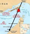 Path of Iran Air 655 and approximate location of downing
 -
 Path of Iran Air 655 and approximate location of downing


Request: Could you please create the Persian versions of the above map?
From top to bottom: Bandar-e Abbas -> بندرعباس / IRAN -> ایران / Jazireh-ye Qeshm -> جزیرهٔ قشم / Bandar-e Lengeh -> بندر لنگه / Strait of Hormoz -> تنگهٔ هرمز / Jazireh-ye Tonb-e Kochek (Lesser Tunb) -> جزیرهٔ تنب کوچک / Jazireh-ye Tonb-e Bozorg (Greater Tunb) -> جزیرهٔ تنب بزرگ / Sea line -> خط دریایی / Oman -> عمان / Abu Musa -> ابوموسی / Ra's al Khaymah -> رأسالخیمه / admin. line -> (I didn't understand what "admin. line" means, so let's ignore it.) / Umm al Qaywain -> امالقوین / Ajman -> عجمان / Dubayy -> دبی / Ash Shariqah (Sharjah) ->
شارجه
Small map on the lower-right corner (from top to bottom): Afghanistan -> افغانستان / Iraq -> عراق / Iran -> ایران / Pakistan -> پاکستان / Persian Gulf -> خلیج فارس / Kuwait -> کویت / Area of Map -> محل نقشه / U.A.E -> امارات / Oman -> عمان / Gulf of Oman -> دریای عمان / Saudi Arabia -> عربستان سعودی / Arabian Sea -> دریای عرب / Yemen -> یمن AMERICOPHILE 07:17, 2 February 2012 (UTC)
Graphist opinion(s):
- Comment: I think the red word is "Area of Map" WhisperToMe (talk) 04:32, 3 February 2012 (UTC)
- I created a new file from existing maps, though SVG format. Please take a look. if it is ok, I will add the texture too.--Pouyana (talk) 11:38, 6 March 2012 (UTC)
- It's far too big due to the paths of the original map outside the viewbox still being there. If you can imagine a little window showing the area you're concerned with, but everything outside the window is still there. I did a version in Illustrator (but without the correct Persian text) that came in at 9kb, at 50kb your version needs some work. Also when one zooms in, the paths representing the coastlines is very angular which gives it a raster type appearence. --Fred the Oyster (talk) 12:32, 6 March 2012 (UTC)
- thanks for the Infos, I will also work on the points you mentioned as well.--Pouyana (talk) 16:31, 6 March 2012 (UTC)
- I created a new file from existing maps, though SVG format. Please take a look. if it is ok, I will add the texture too.--Pouyana (talk) 11:38, 6 March 2012 (UTC)
World same-sex adoption and gender-identity expression laws need .svg versions
-
 Countries that permit adoption by same-sex couples (.png, outdated)
 -
 Countries that recognize gender identity changes (.png, missing some information)


-
 Up-to-date information on U.S. same-sex adoption laws. Also shows the preferred color scheme.
 -
 Andorra (between Spain and France) and Jersey (the UK island northwest of France) have joint adoption, though they're hard to see. The status of Slovenia's step-parent adoption law is currently uncertain, so don't add it despite it being on the above world map.
 -
 Basically, this map says that every U.S. state recognizes gender-identity changes except for Idaho, Ohio, and Tennessee, so reflect that on the world map.


These two maps that show world laws about same-sex adoption and gender-identity changes are out-of-date, not in SVG format, and their color schemes may need to be changed to better reflect other, more up-to-date maps.
Request: Please re-make the top two maps in SVG form. In the new adoption map, make sure that the color scheme is updated to reflect the other adoption maps in the second row (just use gray for any countries where gay adoption is illegal, where homosexuality is illegal, or the situation is unclear). In the new gender-identity change map, make sure that every subdivision of the U.S. except Ohio, Tennessee, and Idaho are added, and that Iran is added (see this). Xnux (talk) 17:00, 2 February 2012 (UTC)
- One done:

Poland 1939-1941

Request: English version, please... --Kintetsubuffalo (talk) 18:45, 2 May 2012 (UTC)
Graphist opinion(s): If you can provide translations, I can make an english version Richardprins (talk) 17:07, 5 May 2012 (UTC)
Gothic map
-
 Description of image

Request: Put it with the Gothic names, as mentioned at http://got.wikipedia.org/wiki/File:Europe.PNG (and perhaps color it). --User:Zscout370 (Return fire) 19:02, 25 May 2012 (UTC)
Graphist opinion(s): If you have a text editor (I recommend w:Notepad++, using the "XML" language option), you should be able to do this easily yourself - just fill in text by the abbreviations near the top of the file. I'd do it myself, but I can't seem to get any of the fonts for Gothic to install properly on my computer, so I can't even see the proper names, let alone reproduce them. --Philosopher Let us reason together. 07:35, 1 August 2012 (UTC)
bad quality map

Request: Please have a look at this one. It has really low quality and is in use. Feel free to either reupload or create a new file. --McZusatz (talk) 20:11, 23 September 2012 (UTC)
Graphist opinion(s):
- Without some source of map data, I'm not sure how much can be done to improve the quality. Powers (talk) 03:03, 28 September 2012 (UTC)
- McZusatz, do you feel the map relates in some way to File:Kingdom of Albania.png or File:Kingdom of Albania in 1368 AD.png ? Is there a visual description anywhere on the internet that I can use, or another way to work it out, from a previous territory from which it inherited its borders ? Penyulap ☏ 22:47, 3 January 2013 (UTC)
Image:新莽时期疆域图(繁).png
-
 Map of Xin Dynasty (original description: 中文: 新莽时期疆域图)

Request: Translate Chinese labels into English. If possible, please upload as SVG. The creator User:玖巧仔 does not exist anymore, but the image is used at zh:User_talk:Jason22, he might be able to help. --Chrishelenius (talk) 16:32, 26 October 2012 (UTC)
Graphist opinion:
do you know where there is a map out on the web that shows the information you'd like ? probably best to answer on my talkpage in case i don't check here. Penyulap ☏ 21:30, 3 January 2013 (UTC)
SVG map needing 3 insets
-
 SVG blank election map in need of 3 insets.

Request: Can you please add 3 insets for the map? One for the very crowded Polk County area in the center of the map, one for the two somewhat-crowded Linn/Johnson county areas in the center-right of the map, and one for Scott county area on the far right of the map? I'm trying to number these legislative districts (see this reference), but these 3 areas are just too crowded to number meaningfully.
The appropriate details are already in the map - they just need to be copied and blown up. Unfortunately, at their current size, they are only visible when you zoom in, which doesn't work so well for use in Wikipedia articles. --– Philosopher Let us reason together. 16:31, 11 January 2013 (UTC)
- In light of the above section, I suppose I should point out that I need the result to retain the .svg formatting, both for accuracy and because I often edit the file via a text editor in addition to Inkscape. – Philosopher Let us reason together. 16:34, 11 January 2013 (UTC)
Graphist opinion(s):
Few things you can do it yourself with a text or XML editor: to me the map needs to double the scale at least which can be done by changing width="600" height="388.04162677065" in the header SVG element to width="1200" height="776" viewBox="0 0 600 388". You can further multiply the width and height values because the native dimension is already defined in the viewBox property. Also the numbers in the regions should be colored white or light grey because blue has low contrast to black. -- Sameboat - 同舟 (talk) 02:57, 14 February 2014 (UTC)
Egypt's governorates
-
 The updated map (in pink)
 -
 The out-of-date map (yes it's pretty but old) - an additional map exists for each governorate to highlight it.


Request: The borders of Egypt's governorates are in quite urgent need of updating. They were significantly modified in the 2000s, but the up-to-date maps are available only in Arabic and in a non-SVG format. It would be greatly appreciated if you could update the SVG which are in current use on most versions of Wikipedia. The new maps were drawn by our colleague user:Faris knight, and he has government sources for the maps he drew (and plenty of other well-sourced historical maps of Egypt; he is an avid geographer).
I apologise for not being able to do this myself yet. Thank you kindly. --عبد المؤمن (talk) 18:58, 29 January 2013 (UTC)
- As requested, here are some official sources. You will not find the old map on any official (or non-official Arabic) website. 1 2 - I am grateful for your response to this request since it is quite important.--عبد المؤمن (talk) 00:24, 18 March 2013 (UTC)
Graphist opinion(s): I would like to have a source apart from a Wikipedia map, then I will update the Egypt map. Is there a link to a government source? NNW (talk) 11:35, 30 January 2013 (UTC)
Translating an SVG map or Corel Draw map
-
Map of Petrograd during the October Revolution
Request: I would like to make a translation of the above map but I found out the text in the map does not seem to be real text (i.e. editable) but merely another curve. I contacted the author and he/she kindly supplied the original Corel Draw map but I could not find a Linux program to try and edit the text there either. I would be grateful if someone could let me know if there is a way to extract the text in the map (either from the SVG or from the Corel Draw version) as real text (ready to copy and paste) so that I can try and translate it. Thank you very much in advance.--Rowanwindwhistler (talk) 19:19, 5 February 2013 (UTC)
Graphist opinion(s):
- If text is once transformed into a path it is impossible to revert this action. That means it is impossible to copy/paste the lettering as wanted. maxxl2 - talk 09:58, 6 February 2013 (UTC)
- A pity, that will complicate things a lot. Thanks for confirming anyway.--Rowanwindwhistler (talk) 14:44, 6 February 2013 (UTC)
Here, I made a blank map, just overlay the text same as they use in the other maps, like locator maps and so on. Probably the help desk can tell you about text overlay. That will make it easy for editors to translate it by cutting and pasting into their preferred languages. The last few blank maps I have made are being used this way, so look at my recent uploads and then follow links through to the articles to view the code other people are using. Penyulap ☏ 15:40, 12 February 2013 (UTC)
- Thanks a lot! Unfortunately my main concern was not getting a blank map (there was one already here though it is not exactly the same) but getting the text so I could copy and paste it into some automatic translator (I do not speak or read Russian) as a first step towards making a Spanish version of the map (the translations tend to be rather bad but they always speed up the process). Thanks for the map anyhow, I will use it as a base for my version though the problem of getting the text recognized as text still remains for me...--Rowanwindwhistler (talk) 15:57, 12 February 2013 (UTC)
- I'm not sure you know what I mean, I'll explain more on your talkpage... Penyulap ☏ 12:26, 13 February 2013 (UTC)
Paraguay visa upon arrival

Request: Paraguay now asks for visa upon arrival, no longer asks for visas prior to arrival to us citizens --Ottojad (talk) 02:06, 26 February 2013 (UTC)
Graphist opinion(s): Like this ? remember to hold down the shift key and click refresh. Penyulap ☏ 10:01, 26 February 2013 (UTC)
Christian Majority Countries
-
 Christian Majority Countries

Request: Hello ! Madagascar must be in red (75% are Christian). However, the Netherlands are no longer in red (see en:Religion in the Netherlands). Thank you. --Mightymights (talk) 14:55, 5 March 2013 (UTC)
Graphist opinion(s): I did not find sources about 75% of Madagascar, can you provide some? -- Fulvio 314 18:35, 15 May 2013 (UTC)
Eastern Hemisphere and the Greco-Persian Wars
-
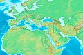
 Eastern Hemisphere in 565 AD
 -
 Greek world during the Greco-Persian Wars (ca. 500–479 BC)
 -


Request: Can you please make a blank version of the 1st map, i'll translate it later. As for the 2nd can you provide an Arabic version of it? Here is a guide for the 2nd [2]. Thank you --باسم (talk) 17:15, 11 March 2013 (UTC)
Graphist opinion(s):
Like this for the first one ? That was complex (or maybe I was doing too much at the same time).
For corrections, because there are artefacts from the text, and lots of them contrary to the first glance, just upload a version of the blank map with brushmarks in the places that need re-doing and I'll redo. Just any old marks will do. Penyulap ☏ 21:09, 11 March 2013 (UTC)
- The second one needs someone into svg. Is it just a matter of pasting the text from one image into the other ? Penyulap ☏ 04:52, 12 March 2013 (UTC)
- Yeah, most of it, the problem is that paint layers used to cover the non-editable text don't blend with the background. I'll upload the image so u'll see--باسم (talk) 14:08, 12 March 2013 (UTC)
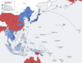
TV introduction world map
-
 Map
Map -
 Flag-map of the People's Republic of China.svg
 -
 like this?


Request: This image was extracted from File:2008 Xingjiang attack.svg per description, but about disputed areas it doesn't reflect any border in reality, and randomly drawn lines are used as border line in disputed areas, instead of claims from either side. Some decision should be made... whether we want to include disputed areas or not in similar maps. Liangent (talk) 11:56, 2 April 2013 (UTC)
Graphist opinion(s): Everyone has their own idea about where borders should be, I think I should have a kingdom and confine all the nasty people to the Arctic circle, but for some reason all my serfs are pretending not to recognise me as their Ruler, what can you do.. Back on Earth it's about the same around the world, so just pick a map you like somewhere on the Internet that has the borders you'd like us to draw, point to it, and we'll use it as the source for a new map. Or ask for several for the different factions, governments, rebels, hairdressers and regimes involved. We can make all of them for you.
Commons tries not to choose which country is correct, we just make maps for everyone. What would you like made 1st ? Penyulap ☏ 12:16, 2 April 2013 (UTC)
- I don't really care which source is used, but its current status is not citing any source (some source is provided, but the map is not mapped according it). Liangent (talk) 12:23, 3 April 2013 (UTC)
- well, I can see what you mean, it looks like the svg was edited in a simplified manner. I don't do svg, if PNG or JPG is ok for you I can do it immediately. As for 'disputed areas in or out' that is up to the requester, that's you :) so if you want one or both for an article somewhere, just ask. Which way they belong is up to the editors of the article on whatever project it is. Penyulap ☏ 13:03, 3 April 2013 (UTC)
- Like this? Penyulap ☏ 13:33, 3 April 2013 (UTC)
- well, I can see what you mean, it looks like the svg was edited in a simplified manner. I don't do svg, if PNG or JPG is ok for you I can do it immediately. As for 'disputed areas in or out' that is up to the requester, that's you :) so if you want one or both for an article somewhere, just ask. Which way they belong is up to the editors of the article on whatever project it is. Penyulap ☏ 13:03, 3 April 2013 (UTC)
Bad day
-
 Canoe boo-boo

I made this image to highlight this park. The circle doesn't show well in the infobox at w:Syringa Provincial Park though. I spelt the park wrong in the file name. Should I just do a darker circle or is it easy to make a map that shows the borders? Here are some links that show the location better.--Canoe1967 (talk) 19:52, 21 April 2013 (UTC)
Location maps Philippines


Request:
- Can derivative maps be made of these two, showing more of the east and west to create an image with an aspect ration of 1:1? Thanks. -- P199 (talk) 16:42, 29 April 2013 (UTC)
Graphist opinion(s):
- The relief map can't be expanded without access to the underlying relief data. Have you considered asking the author, User:Carport? Powers (talk) 14:23, 3 May 2013 (UTC)
- No reply from the original author. Maybe the plain map can be done for now? --P199 (talk) 15:01, 13 June 2013 (UTC)
What about these maps?
.svg)
.svg)
Hellerick (talk) 16:37, 16 June 2013 (UTC)
- Looks good. Thanks! --P199 (talk) 13:02, 17 June 2013 (UTC)
Introducing new {{Map}} template
Introducing new {{Map}} template. Please come and help designing and developing it. --Jarekt (talk) 13:40, 20 June 2013 (UTC)
SVG blank map of the world in 1938
-

-
 Based on this one

For use in various articles on interwar period.
Request:
- A blank SVG map of the world in 1938, just before German annexation of Austria. There is one (for 1937, but no major changes in borders took place in between, iirc) in PNG, but it awkward to modify and use. --Saə (talk) 14:29, 3 August 2013 (UTC)
Graphist opinion(s):
- I have made a map for 1937. Is it okay?

- Hellerick (talk) 08:23, 18 October 2013 (UTC)
.svg)
SVG topographic map of the British Isles
-
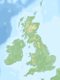
 SVG / raster topographic map of Scotland
 -
 Raster topographic map of the United Kingdom
 -
 SVG Map of the the Hebrides


Article(s): A map from which further maps can be adapted for use in any geography article concerning Britain and/or Ireland.
Request:
- A topographic map of the United Kingdom of quality as good as those illustrated above. The "Scotland topographic map-en.svg" above is actually just a vector layer above a raster map, hence its vast size. The "SeaHebrides TheMinch map-fr.svg" in contrast has the relief vectorised also. If anyone is skilled enough and has time enough to vectorise all the British Isles like that, we would have a resource at a reasonable file size from which other maps could be adapted. (Is someone already doing that?) --Hogweard (talk) 21:04, 2 November 2013 (UTC)
Graphist opinion(s):
- What about this one? Hellerick (talk) 08:44, 6 November 2013 (UTC)
- Crumbs, that's good, and fast. Well done you. Hogweard (talk) 19:59, 7 November 2013 (UTC)
Coordinate fix or new pair of maps needed for Location maps of Mari El
-
 Map of Mari El Republic in Russia.
 -
 Relief map of Mari El Republic.


Article(s): Used as basis for Location maps for this region, which is used e.g. as dynamical map in Finnish Wikipedia article fi:Marin tasavalta. Same base maps are used in location map templates in most major languages of wikipedia, like in en:Template:Location map Russia Mari El.
Request:
- There is something wrong with coordinates of this particular map, maybe projection or similar is wrong. As a result of this locations of cities like en:Kozmodemyansk are misplaced. In reality this city is on the southern bank of en:Volga River (or en:Cheboksary Reservoir), not on the northern bank. I could not find any clear error with the borders of this (these) map(s) (originally I noticed this problem already in February 2013), so simple relocation of borders or scaling does not fix the problem. Maybe somebody could generate a new pair of maps, which could be used to replace the erroneous ones in location map templates?
--Paju (talk) 23:46, 22 December 2013 (UTC)
Graphist opinion(s):
- I tried to fix it but it is senseless. It has to be rotated, perhaps it has even got a wrong projection. This has to be made anew. NNW 10:56, 23 December 2013 (UTC)
- It seems like a neat conic equidistant projection to me. I think I can do it. Hellerick (talk) 06:14, 24 December 2013 (UTC)
- I remade the template for Russian wikipedia. Not perfect, but it seems better now (see here). I am not sure how to change the templates in other wikis. Hellerick (talk) 07:01, 24 December 2013 (UTC)
- Could you explain more clearly, what was changed? Is there some equation used for x and y now, instead of giving border coordinates of the map (previous approach)? The new Russian template included type=custom instead of border coordinates. But the way location information (lat, lon) is exactly processed, is not shown there template. I'd be happy to try to test this new approach and if all is ok, change the (template used in fiwiki). To be able to do this, I would appreciate if explanation or equation how x and y are calculated/plotted now would be included, either here or as a comment in the ruwiki template. --Paju (talk) 17:26, 26 December 2013 (UTC)
- All you had to do was to click x and y in the template. The formulas for them are kept at separate sub-pages. Hellerick (talk) 03:43, 27 December 2013 (UTC)
- Unfortunately, that approach stops short, does not work ok. When trying these hyperlinks, an error message " Перейти к: навигация, поиск Ошибка выражения: неопознанный символ пунктуации «{» " appears. On the category page of ruwiki for such coordinates, there are also several other examples which do not open properly. Instead, error message reports about code structure (*, {, or similar character). Possibly there is some coding typo? However, some like ПозКарта Африка/x behave well. --Paju (talk) 11:18, 27 December 2013 (UTC)
- FYI: Even though hyperlink does not work, opening x and y in editor allows me to read the equations used.--Paju (talk) 11:34, 27 December 2013 (UTC)
- Location map template used in fiwiki has been updated and fix works ok. Thank you! It is suggested that Other wikis could update their Location maps as well.--Paju (talk) 12:22, 27 December 2013 (UTC)
- Unfortunately, that approach stops short, does not work ok. When trying these hyperlinks, an error message " Перейти к: навигация, поиск Ошибка выражения: неопознанный символ пунктуации «{» " appears. On the category page of ruwiki for such coordinates, there are also several other examples which do not open properly. Instead, error message reports about code structure (*, {, or similar character). Possibly there is some coding typo? However, some like ПозКарта Африка/x behave well. --Paju (talk) 11:18, 27 December 2013 (UTC)
- All you had to do was to click x and y in the template. The formulas for them are kept at separate sub-pages. Hellerick (talk) 03:43, 27 December 2013 (UTC)
- Could you explain more clearly, what was changed? Is there some equation used for x and y now, instead of giving border coordinates of the map (previous approach)? The new Russian template included type=custom instead of border coordinates. But the way location information (lat, lon) is exactly processed, is not shown there template. I'd be happy to try to test this new approach and if all is ok, change the (template used in fiwiki). To be able to do this, I would appreciate if explanation or equation how x and y are calculated/plotted now would be included, either here or as a comment in the ruwiki template. --Paju (talk) 17:26, 26 December 2013 (UTC)
Cambridge electoral wards
Article(s): en:Cambridge


Request:
- Can someone please vectorise en:File:CambridgeWards.png and not use Comic Sans (argh)? Where can one check if the boundaries are still valid? --cmglee (talk) 12:15, 14 April 2014 (UTC)
Graphist opinion(s):
- Here we have a blank map of Cambridge wards already. If you like to check the boundaries, check the data from Ordnance survey. After your check and your ok, the text will be inserted. --Maxxl2 - talk 08:01, 18 April 2014 (UTC)
- Request taken by Maxxl2 - talk 09:09, 18 April 2014 (UTC)
- Done --Maxxl2 - talk 13:13, 18 April 2014 (UTC)
- Thank you very much, Maxxl2. I've combined it with Cambridge-Openstreetmap-08-06-13.svg and fixed the spelling of "Newnham". cmglee (talk) 16:19, 21 April 2014 (UTC)
Uzbekistan map
-
 Map of Uzbekistan

Article(s): Uzbekistan
Request:
- The map of Uzbekistan is a complete mess, please fix it or upload a new version. --WhyHellWhy (talk) 00:22, 9 May 2014 (UTC)
Graphist opinion(s):
- Fixed. Hellerick (talk) 04:05, 9 May 2014 (UTC)
Orthographic maps
.svg)
.svg)
Request:
- Please remove the antarctic claims, these do not belong to a neutral named orthographic projection map. I'll upload the old version under a new name then. --Denniss (talk) 17:19, 17 May 2014 (UTC)
Graphist opinion(s):
- Request taken by Goran tek-en (talk) 17:54, 23 June 2014 (UTC)
![]() Done Dennis I trust that you will upload the ones with the claims as new file as I uploaded as new version. --Goran tek-en (talk) 18:10, 23 June 2014 (UTC)
Done Dennis I trust that you will upload the ones with the claims as new file as I uploaded as new version. --Goran tek-en (talk) 18:10, 23 June 2014 (UTC)
Translate File:British Isles.svg into Malay language
-
 File that need to be translated
 -
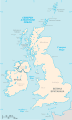 Image file in Macedonian (mk) language
 -
 Translation (embedded in original file)


Article(s): Kepulauan British (en)
Request:
- Translate the file into bahasa Melayu (ms)... --26 Ramadan (talk) 01:09, 20 May 2014 (UTC)
| English (en) | Malay (ms) |
|---|---|
| North Atlantic Ocean | Lautan Atlantik Utara |
| Shetland Islands | Kepulauan Shetland |
| North Ronaldsay | Ronaldsay Utara |
| Orkney Islands | Kepulauan Orkney |
| South Ronaldsay | Ronaldsay Selatan |
| Outer Hebrides (Western Isles) | Hebrides Luar (Kepulauan Barat) |
| North Uist | Uist Utara |
| South Uist | Uist Selatan |
| Barra Island | Barra |
| North Sea | Laut Utara |
| Inner Hebrides | Hebrides Dalam |
| Coll Island | Coll |
| Rathlin Island | Rathlin |
| Tony Island | Tony |
| Farne Islands | Kepulauan Farne |
| Northern Ireland | Ireland Utara |
| Isle of Man | Pulau Man |
| Irish Sea | Laut Irish |
| Clew Bay Islands | Kepulauan Teluk Clew |
| Aran Islands | Kepulauan Aran |
| Republic of Ireland | Republik Ireland |
| Holy Island | Pulau Holy |
| Lundy Island | Lundy |
| Celtic Sea | Laut Celtic |
| English Channel | Selat Inggeris |
| Isles of Scilly | Kepulauan Scilly |
| Isle of Portland | Pulau Portland |
| Isle of Wight | Pulau Wight |
| miles | batu |
Graphist opinion(s):
- Done Let me know if I missed any or if you want any more words translated. The translation is achieved using <switch> elements; use [[File:British Isles.svg|lang=ms]] to make it appear on a page. NikNaks talk - gallery - wikipedia 03:08, 20 May 2014 (UTC)
SVG syntax problem in 2 maps
-
 Map of Egypt under Muhammad Ali Dynasty.
 -
 Map of Egypt and its neighbors 1880 in German.


Article(s): es:Mehmet Alí & others
Request:
- I have made Spanish versions of the above files (here and here) but neither the old or the new wizard will allow me to upload the maps. There must be something wrong in the original files that prevents the uploading. Could someone please check what that may be and upload my translations so that they can be used in the Spanish articles of Wikipedia? Thank you in advance.--Rowanwindwhistler (talk) 22:24, 11 July 2014 (UTC)
Graphist opinion(s):
- You would have to tell us more specific what error you get. You can't use the same name for the files.
- At this link svgcheck you can check your svg, it renders it the same way as commons does. --Goran tek-en (talk) 18:28, 10 August 2014 (UTC)
- I am not really using the same names as the original files, I am using similar ones with the -es extension (for Spanish). All that the upload wizard seems to say is: "Egypt_under_Muhammad_Ali_Dynasty_map_es.svg This file might be corrupt, or have the wrong extension.". But the mentioned tool does show (among many warnings) one error: "Line 90: *ERROR* Local file reference found. These will not work (and may be blocked) by the Wikimedia software. All required elements need to be included in the SVG directly." Not sure what that means as I only changed text... Thank you.--Rowanwindwhistler (talk) 20:24, 10 August 2014 (UTC)
- Hello again, I think this request can be closed. Thanks to the SVG online checker I looked for the error line and removed some strange tag that was pointing to a local file. It seems the removal does not break anything and now I can upload the maps. Thank you very much for all your help!--Rowanwindwhistler (talk) 09:46, 11 August 2014 (UTC)
- Very good. What it means is that within the svg file there was a link to a local file (probably a bitmap) and that has to be included if the upload should work. It can be a forgotten string from an earlier version and at that stage the upload didn't check for stuff like that. I will close this now. --Goran tek-en (talk) 15:11, 11 August 2014 (UTC)
![]() Done:This section was archived on a request by: Goran tek-en (talk) 15:11, 11 August 2014 (UTC)
Done:This section was archived on a request by: Goran tek-en (talk) 15:11, 11 August 2014 (UTC)
SVG version for easy translation
-
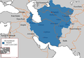 Khwarezmian Empire (1190-1220)
.PNG)
Article(s): es:Irán,es:Imperio mongol,es:Ilkanato,es:Qarajanida,es:Corasmia,es:Jorezmitas,es:Invasión mongola de Corasmia,es:Anexo:Imperios por superficie
Request:
- Turn the above map into SVG so that it can be translated. I would like to create a Spanish translation of the new SVG version to use in many Spanish articles where the English version is currently being used. Thank you. --Rowanwindwhistler (talk) 22:28, 11 July 2014 (UTC)
Graphist opinion(s):
- Request taken by Rcsprinter123 (talk) 08:23, 1 August 2014 (UTC)
- Done - see File:Khwarezmian Empire 1190 - 1220 (AD).svg. After translating text to Spanish, be sure to convert it to path so that the font shows up correctly when uploaded. Rcsprinter123 (talk) 09:56, 1 August 2014 (UTC)
- Excellent! Many thanks, I just added a few missing parts, changed the colours and font (it looks ok to me as text) and translated as planned. Thanks again!--Rowanwindwhistler (talk) 11:02, 1 August 2014 (UTC)
- This section was archived on a request by: Rcsprinter123 (talk) 13:10, 1 August 2014 (UTC)
File:Blank Map of France, with Communes bw.svg
-
 Blank Map of France, with Communes bw

Request: There are ugly lines on the map (PNG versions), although you won't see them if you open the file directly (SVG version). How can I delete those lines? --Monsieurbecker (talk) 19:20, 11 June 2012 (UTC)
Graphist opinion(s): Ugly lines due to svg to png convertor which probably have problems with complex paths. In this case paths of cities with enclaves and exclaves (see : w:Enclave or w:Liste d'enclaves et d'exclaves intérieures de la France).
![]() Request taken by Jneba (talk): 20:00, 11 August 2014 (UTC);
Request taken by Jneba (talk): 20:00, 11 August 2014 (UTC);
![]() Done: 22:00, 11 August 2014 (UTC).
Done: 22:00, 11 August 2014 (UTC).
Need a map version with English language labels
-
 Map of world showing areas of groundwater contaminated with arsenic

Request: Produce another image that has English rather than German labels for the countries. Alan Liefting (talk) 21:42, 3 July 2012 (UTC)
Graphist opinion(s):
Validation of SVG map
-
 Indian rivers and lakes

Article(s): es:Río Godavari and a few others
Request:
- I would need help finding out why the upload wizard rejects the uploading of the Spanish version of the file above (to be found here). I tried using this tool that shows many warnings but no errors. What is wrong in this SVG? Besides, I would like to have a JPG that seems to be there somewhere removed, if possible. Thank you in advance.--Rowanwindwhistler (talk) 20:49, 29 August 2014 (UTC)
Graphist opinion(s):
- I extracted a pixel image and uploaded the file here. -- Maxxl² - talk 21:29, 29 August 2014 (UTC)
- Thank you! It looks good to me, it seems the JPG was not really important to the map itself (good). Shall I download this file, rename it and uploaded it again or can it be renamed to India_rivers_and_lakes_map-es.svg straightaway? My goal is to replace the English-labeled file with the Spanish one in the Spanish Wikipedia where the original file is currently being used...--Rowanwindwhistler (talk) 22:24, 29 August 2014 (UTC)
- I guess most appropiate is you just download the test.svg, trim its size and upload it again with the proper name you want. -- Maxxl² - talk 22:39, 29 August 2014 (UTC)
- I just managed to upload it a moment ago (Commons seems to identify the map even if the name is changed if the content is the same to an existing file, so I have to move some labels around). I think this can be marked as done. Thank you!--Rowanwindwhistler (talk) 06:00, 30 August 2014 (UTC)
- I guess most appropiate is you just download the test.svg, trim its size and upload it again with the proper name you want. -- Maxxl² - talk 22:39, 29 August 2014 (UTC)
- Thank you! It looks good to me, it seems the JPG was not really important to the map itself (good). Shall I download this file, rename it and uploaded it again or can it be renamed to India_rivers_and_lakes_map-es.svg straightaway? My goal is to replace the English-labeled file with the Spanish one in the Spanish Wikipedia where the original file is currently being used...--Rowanwindwhistler (talk) 22:24, 29 August 2014 (UTC)
- This section was archived on a request by: Maxxl² - talk 12:22, 30 August 2014 (UTC)
Projection for SVG map?
-
 Samanid dynasty
.GIF)
Article(s): es:Imperio kushán, es:Samánidas, es:Imperio gaznávida,es:Qarajanida, es:Dinastía ziyárida, es:Dinastía búyida, es:Dinastía saffarí, es:Dinastía alavida, es:Anexo:Imperios por superficie
Request:
- I am trying to create Spanish SVG versions of the above map and others with the same base map but I do not seem to find which is the projection used there. I have tried this, this and this with no luck. I cannot make the raster map to fit the SVG. Would anyone know which projection the original map has or where I could find an SVG map I can use as a basis for the conversion? Thank you! --Rowanwindwhistler (talk) 21:18, 14 September 2014 (UTC)
Graphist opinion(s):
- Did you ask the author HistoryofIran already? -- Maxxl² - talk 09:06, 15 September 2014 (UTC)
- Good point... No, not yet. I thought someone here might know... But I will do so shortly as it may indeed be easier (finding the projection in SVG may not be though)...--Rowanwindwhistler (talk) 11:52, 16 September 2014 (UTC)
- It's the equirectangular projection like in File:World location map (equirectangular 180).svg. NNW 12:40, 16 September 2014 (UTC)
- It is indeed! Thank you.--Rowanwindwhistler (talk) 19:52, 16 September 2014 (UTC)
- Incidentally, I forgot to mention this request can be marked as done, I managed to create the SVG maps. Thank you!--Rowanwindwhistler (talk) 16:48, 18 September 2014 (UTC)
- This section was archived on a request by: Maxxl² - talk 07:20, 19 September 2014 (UTC)
-
 Description of first image

Article(s): Maginot Line, World War Two
Request:
- Can someone make svg version of this file so it can be easily translated? -- Bojan Talk 20:03, 24 October 2014 (UTC)
Graphist opinion(s):
- Request taken by Goran tek-en (talk) 18:31, 18 November 2014 (UTC)
- @BokicaK:
- There are some black dots in the png, do you want them as well, and if so should they not also be in the legend with an explanation?
- Now you can look at a draft here. Give me feedback on this, thanks. --Goran tek-en (talk) 13:31, 20 November 2014 (UTC)
- @BokicaK:
Thank @Goran tek-en: , that would be fine. -- Bojan Talk 14:18, 20 November 2014 (UTC)
- @BokicaK: This file will be uploaded to commons so I will need;
- Name of the file
- Description
- Category/ies
- So the black dots should not be included? --Goran tek-en (talk) 19:26, 20 November 2014 (UTC)
- @BokicaK: This file will be uploaded to commons so I will need;
- @Goran tek-en: , I don't know what black dots represent.
- Name of file: Maginot Line ln-en.svg
- Description: Maginot Line in France.
- Category: Maginot Line. -- Bojan Talk 05:11, 23 November 2014 (UTC)
- @Goran tek-en: , I don't know what black dots represent.
@BokicaK: Now you can find it here: Maginot Line in France. --Goran tek-en (talk) 19:11, 23 November 2014 (UTC)
![]() Done:This section was archived on a request by: Goran tek-en (talk) 19:11, 23 November 2014 (UTC)
Done:This section was archived on a request by: Goran tek-en (talk) 19:11, 23 November 2014 (UTC)
Add a heading for your request here!
-
Description of first image
-
Description of second image (if needed)
-
Description of third image (if needed; don't request too many at once, though)
- Article(s)
- [[]]
- Request
- Details of your request go here… --105.134.169.222 20:44, 4 December 2014 (UTC)
- Graphist opinion(s)
THis is nothing. :This section was archived on a request by: Goran tek-en (talk) 12:47, 12 December 2014 (UTC)
Map to SVG
-
 Mediterranean at 218 BC)

- Article(s)
- Several dozen, you can see on the photo page.
- Request
- The map is now on jpg, and Vector version is needed. It is hard to reed the letters on the map and it does not look well on medium size. thanks, --Eitan96 (talk) 11:13, 4 December 2014 (UTC)
- Graphist opinion(s)
![]() Request taken by Goran tek-en (talk) 13:03, 4 December 2014 (UTC)
Request taken by Goran tek-en (talk) 13:03, 4 December 2014 (UTC)
- @Eitan96: Now there is a draft for you to look at. It's wide in pixels so you probably have to zoom out to view the whole. Give me feedback on it and it's you who have the knowledge so tell me what to change. A bitmap is always fuzzy so there might be meetings of different areas that has to be adjusted.
- South west of Athens there is a darker brown area which doesn't exist in the legend, should it be included?
- South west of Athens there is a darker brown area which doesn't exist in the legend, should it be included?
- Get back to me with feedback, thanks. --Goran tek-en (talk) 19:36, 5 December 2014 (UTC)
- Hi Goran tek,sorry for my late answer. Your map look fine, thank you! just a little thing, the border between two different colors there is most of of time a some distance and there is some place without special color at the middle. except this it great. thanks again, Eitan96 (talk) 11:37, 14 December 2014 (UTC)
- @Eitan96: That was exactly what I meant by the bitmap being fuzzy. I couldn't be sure if the areas should meet or not. Now there is new draft , reload page for you to look at.
- There are some areas around Athens and Nicomedia which I don't know if they should be filled or not, so get back to me with feedback, thanks. --Goran tek-en (talk ) 14:08, 14 December 2014 (UTC)
- @Goran tek-en: , yes, this area should be same color as Antigonides (purple) and should be a little bigger - same as the yellow at this map. thanks, Eitan96 (talk) 15:30, 14 December 2014 (UTC)
- @Eitan96: New draft , reload page. Anything else to change? --Goran tek-en (talk) 17:07, 14 December 2014 (UTC)
- No, it's great. thank you very much! Eitan96 (talk) 12:31, 15 December 2014 (UTC)
@Eitan96: Now you can find it here Mediterranean at 218 BC --Goran tek-en (talk) 19:26, 15 December 2014 (UTC)
![]() Done:This section was archived on a request by: Goran tek-en (talk) 19:26, 15 December 2014 (UTC)
Done:This section was archived on a request by: Goran tek-en (talk) 19:26, 15 December 2014 (UTC)
- Thank you very much! Eitan96 (talk) 06:57, 16 December 2014 (UTC)
Add heading for request here!
-
 EB9 map of Denmark

Article(s): s:Encyclopædia_Britannica,_Ninth_Edition/Denmark (maybe some other historic articles on Denmark)
Request:
- If someone has the time, this one is a little tricky. The original page scan is a little twisted and needs to be slightly rotated; the text can be stripped to allow something like this but there's a piece hanging above the top of the border that needs to be kept, which means leaving some white space and just removing the text and other elements from it. (Preferably transparently.)
- If someone takes this up, thanks, but don't replace the original file which includes the whole page: just upload the edited form and link them together.--LlywelynII (talk) 23:53, 29 August 2014 (UTC)
Graphist opinion(s):
- Request taken by Goran tek-en (talk) 17:51, 22 December 2014 (UTC) Have a look at it and see if I understood you right. I didn't do exactly as you wrote, to me this is better. If you don't like it just tell me and what to change. I will be away for almost two weeks now. --Goran tek-en (talk) 17:51, 22 December 2014 (UTC)
- EB9 Denmark-1878
![]() Done:This section was archived on a request by: Goran tek-en (talk) 17:51, 22 December 2014 (UTC)
Done:This section was archived on a request by: Goran tek-en (talk) 17:51, 22 December 2014 (UTC)
SVG version of map
- This section was archived on a request by: Rowanwindwhistler (talk) 11:49, 23 February 2015 (UTC)
-
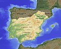 The Emirate of Cordoba in 910

Article(s): es:Abderramán III, es:Historia de la región mediterránea
Request:
- I wonder if an SVG version of this map could be drawn so that it can be easily translated into other languages. Thank you. --Rowanwindwhistler (talk) 06:47, 27 July 2014 (UTC)
Graphist opinion(s):
- @Rowanwindwhistler: I don't understand what type of map you want. A relief like the one above or more of a location map which doesn't show mountains and so on?
- I have found a svg with some mountains Peninsular War Map so if that one is OK as a base I can do it for you. Get back to me, thanks. --Goran tek-en (talk) 13:10, 12 December 2014 (UTC)
- Sorry for my late reply, it seems I am not getting the notifications anymore for some reason... That map looks nice as a base but it seems the modern borders are not overlapping the geographical data but replacing it so I do not know how easy it would be to remove them... My goal would be to get an equivalent map of the png map but in SVG, so that we can have versions in different languages (I would like to have an Spanish version for the Spanish Wikipedia, for those who do not understand German). Thank you!--Rowanwindwhistler (talk) 08:56, 16 December 2014 (UTC)
- I found a base SVG map and managed to create a SVG version in the end.--Rowanwindwhistler (talk) 11:49, 23 February 2015 (UTC)
Map of the Ajanta Caves
Article(s): en:Ajanta Caves
Request:
- The maps of Ajanta caves we have now are copyright violations. Could you please create a new one ?
See Commons:Deletion requests/Files in Category:Maps and plans of the Ajanta Caves. Thanks in advance for your help, --Yann (talk) 19:56, 18 October 2014 (UTC)
Graphist opinion(s):
- @Yann: As the images have been deleted now it isn't possible for graphists to recreate them. Can you upload one of those image, maybe with lesser resolution on en wiki with rationale for time being? Am not graphist as such, but if simple, i can give it a try like i did with File:Siddheshwar map.png. §§Dharmadhyaksha§§ {Talk / Edits} 16:16, 14 November 2014 (UTC)
- Or provide us with an external link, if you can find one, of those maps. §§Dharmadhyaksha§§ {Talk / Edits} 03:02, 15 November 2014 (UTC)
- @Dharmadhyaksha: Sorry, I didn't notice your message. Here is a copy of the map: [3]. Regards, Yann (talk) 09:31, 29 November 2014 (UTC)
- @Yann: Request taken by Goran tek-en (talk) 14:19, 31 March 2015 (UTC)
- @Yann: Now there is a draft for you to look at. Give me feedback, thanks. --Goran tek-en (talk) 19:18, 4 April 2015 (UTC)
- It looks quite good. Could you add the ASI office and the paths? Regards, Yann (talk) 19:28, 4 April 2015 (UTC)
- @Yann: Now there is a draft for you to look at. Give me feedback, thanks. --Goran tek-en (talk) 19:18, 4 April 2015 (UTC)
- @Yann:
- @Dharmadhyaksha: Sorry, I didn't notice your message. Here is a copy of the map: [3]. Regards, Yann (talk) 09:31, 29 November 2014 (UTC)
- Or provide us with an external link, if you can find one, of those maps. §§Dharmadhyaksha§§ {Talk / Edits} 03:02, 15 November 2014 (UTC)
@Yann: New draft for you to look at.
I will need the following;
- Name of the file
- Description
- Category/ies at commons
to be able to upload it at commons. Give me feedback, thanks. --Goran tek-en (talk) 15:46, 5 April 2015 (UTC)
- File:Map of Ajanta Caves.svg, with Category:Maps and plans of the Ajanta Caves seems fine. Regards, Yann (talk) 16:16, 5 April 2015 (UTC)
- Now you can find it here: Map of Ajanta Caves. --Goran tek-en (talk) 17:51, 5 April 2015 (UTC)
![]() Done
Done
- This section was archived on a request by: Goran tek-en (talk) 17:51, 5 April 2015 (UTC)
Map of Corfu Channel
-
 Map of the Island of Corfu
 -
 cropped


Article(s): en:Corfu Channel incident, en:Corfu Channel case
Request:
- I'm hoping to have a detail produced from this map, focused on the northern part of the Corfu Channel. I'm thinking cropped to Saranda in Albania in the north; Gouvia on Corfu in the west; Corfu City in the south; and Xarre in Albania in the east. I just don't know enough about working with SVG to trim it while keeping the legend and scale elements. —/Mendaliv/2¢/Δ's/ 01:32, 17 July 2014 (UTC)
Graphist opinion(s):
![]() Request taken by Fulvio 314 07:44, 12 October 2014 (UTC)
Request taken by Fulvio 314 07:44, 12 October 2014 (UTC)
![]() Done
Done
- This section was archived on a request by: Yann (talk) 20:05, 5 June 2015 (UTC)
Need a map of the Kakatiya Empire in India
Article(s): https://en.wikipedia.org/wiki/Kakatiya_dynasty
Request:
- Hi, would someone be kind enough to make a map detailing the borders of the Kakatiya Empire at its height?
The maps for reference can be found in these google books:
1 (Corrected Link November 2014)
Graphist opinion(s):
- You haven't signed your request which would have been great.
- The first link is broken so please correct that, and what kind of map do you want. Just lines like your second link or what?
- Would also be great if you told me where in India this was?
This is roughly located between 13 degrees N and 20 degrees N and 75 degrees E and 82 degrees E. Lateraldissonance (talk)
- If you want me to fulfill this request provide me with the needed information, and send me a message and I will do it. Thanks --Goran tek-en (talk) 11:48, 3 January 2014 (UTC)
- @Lateraldissonance: Thanks for that but the first link says that "either it can't show that page or it has reached maximal shows of the book". And what page should it be if it worked?
- The second link shows a cover of a book and some information on it, I can't see how to view it and if so what page?
- I recommend that you make a screen print of the page/map you mean and send it to me on email from my user page. I really would like to get a map with higher resolution if you have that. I can't do anything until you have sent me the maps, thanks. --Goran tek-en (talk) 11:51, 29 November 2014 (UTC)
- @Lateraldissonance: Thanks for that but the first link says that "either it can't show that page or it has reached maximal shows of the book". And what page should it be if it worked?
- This section was archived on a request by: Storkk (talk) 12:58, 5 August 2015 (UTC)
Kiskirályok uralmi területei.jpg
-
 Hungarian map

.png)
_location.svg)
_location.svg)
.png)
.png)
_1917,%D0%9A%D0%B0%D1%80%D1%82%D0%B0-%D1%81%D1%85%D0%B5%D0%BC%D0%B02.svg)
![[2]](https://commons.wikimedia.org/wiki/File:Map_Macedonia_336_BC-ar.svg)
.svg)
.svg)
.svg)
![[3]](https://dl.dropboxusercontent.com/u/87404382/Ajanta%20Caves%20map.jpg)
- Article(s)
- Lot of articles on medieval Hungary and Croatia.
- Request
- It would be nice if there is SVG version that can be easily localized. Just leave Hungarian names, I will translate map to Engish -- Bojan Talk 04:24, 25 December 2014 (UTC)
- Graphist opinion(s)
![]() Request taken by Goran tek-en (talk) 18:32, 16 July 2015 (UTC)
Request taken by Goran tek-en (talk) 18:32, 16 July 2015 (UTC)
@BokicaK: I actually think it will be easier for me if you gave me the English translations or you write the different Hungarian names here as I don't know how to find all the different letters, thanks. Also I need the translations to English to understand the legend and pick the right symbols for the different things. --Goran tek-en (talk) 18:32, 16 July 2015 (UTC)
- @BokicaK: I really need your help to be able to complete your request.
- I need translations as above.
- What are the two different shades of yellow?
- What is the dotted line? --Goran tek-en (talk) 16:57, 25 July 2015 (UTC)
- Thanks @Goran tek-en:
- Dotted lines (pale yelow) represent areas of separatist oligarchs.
Sorry. This is translation: Nemet-Romai Birodalom - Holly Roman Empire Szerb Kiralysag - Serbia Havasalfold - Golden Horde Moldva - Galicia–Volhynia Lengel Kiralusag - Poland Ujlak - Ilok Kapronca - Koprivnica
Jelentos uralmi kospont - important fortreses csatahely (Karoly Robert Országegyesítő haborui )- victories/battle(ground)s (Charles Robert's War of Unification) -- Bojan Talk 07:54, 26 July 2015 (UTC)
- @BokicaK: Now there is a draft for you to look at.
- I'm not sure I understood your translations.
- I need a translation for the heading.
- I don't think I got all the island in the right color. Give me feed back, thanks. --Goran tek-en (talk) 17:09, 29 July 2015 (UTC)
- @Goran tek-en: Can you say what precisely you could' understand? I think that borders between region should be narrower, so You don't need to think on islands. Charles Robert at the beginning controlled only central part of Hungary. -- Bojan Talk 13:36, 30 July 2015 (UTC)
- @BokicaK: You could check the draft for which names, area names and so on it that is wrong. It was mostly the outside area names I was not sure about. You also had given me translations that I couldn't find in the map so that's why I got confused on which to use. So please check the draft.
- I need a translation for the map headline at the top.
- The reason why I made the separatists areas like that is because it's like that in the image you provided as source. In this draft I have drawn the three areas in the east closer. Do you want it like that?
- Should we not have an explanation for what the "dark" yellow is, I have asked you before. --Goran tek-en (talk) 18:34, 30 July 2015 (UTC)
- @BokicaK: You could check the draft for which names, area names and so on it that is wrong. It was mostly the outside area names I was not sure about. You also had given me translations that I couldn't find in the map so that's why I got confused on which to use. So please check the draft.
- @Goran tek-en: Can you say what precisely you could' understand? I think that borders between region should be narrower, so You don't need to think on islands. Charles Robert at the beginning controlled only central part of Hungary. -- Bojan Talk 13:36, 30 July 2015 (UTC)
- Dark yellow is Charles Robert's domain. Replace Heading XXXX with Charles Robert's War of unification. I'm satisfied with current map. -- Bojan Talk 01:32, 31 July 2015 (UTC)
- But do you want the light yellow areas with distance in between or close together as the three areas on the right hand side (I just did those three to see if that was what you want)? --Goran tek-en (talk) 18:00, 1 August 2015 (UTC)
- Dark yellow is Charles Robert's domain. Replace Heading XXXX with Charles Robert's War of unification. I'm satisfied with current map. -- Bojan Talk 01:32, 31 July 2015 (UTC)
- @Goran tek-en: Yes, I want something lake eastern part. I'm pretty sure that river are borders between separatist realms. -- Bojan Talk 06:05, 2 August 2015 (UTC)
- @BokicaK: I agree on the rivers but my problem is that we have a single line between the areas but in our source it's two lines with space in between so which line am I using in relation to the rivers, interesting. Any way I have tried to make the most obvious rivers follow the lines/borders.
- Have a look at this draft and give me feedback, thanks. --Goran tek-en (talk) 17:48, 2 August 2015 (UTC)
- @BokicaK: I agree on the rivers but my problem is that we have a single line between the areas but in our source it's two lines with space in between so which line am I using in relation to the rivers, interesting. Any way I have tried to make the most obvious rivers follow the lines/borders.
- @Goran tek-en: Yes, I want something lake eastern part. I'm pretty sure that river are borders between separatist realms. -- Bojan Talk 06:05, 2 August 2015 (UTC)
- @Goran tek-en: Good. You can upload map here. Just make those three islands pale yellow. -- Bojan Talk 14:37, 4 August 2015 (UTC)
@BokicaK: I will need the following;
- Name of the file
- Description
- Category/ies at commons
to be able to upload it at commons. --Goran tek-en (talk) 17:58, 4 August 2015 (UTC)
- Filename - File:Oligarchs in the Kingdom of Hungary.svg
- Description - The provinces ruled by the "oligarchs" (powerful lords) in the early 14th century
- Categories Maps of the Kingdom of Hungary Charles I of Hungary
-- Bojan Talk 20:35, 4 August 2015 (UTC)
@BokicaK: Now you can find it here Oligarchs in the Kingdom of Hungary 14th century
If you are going to make translations of the map, there are are another text with just a line under the texts that breaks a river, border and so on. This is to make it more readable, so you will have to edit them to. Maybe some words are longer in the other language and then you have to add that text with line, blur, round corners, color for it. I don't know how you make the translations or how much you know of this. If you want I can help you with that, just send me a message, thanks. --Goran tek-en (talk) 10:53, 5 August 2015 (UTC)
![]() Done
Done
- This section was archived on a request by: Goran tek-en (talk) 10:53, 5 August 2015 (UTC)