User talk:NordNordWest
|
Welcome to my user talk page! I like to keep discussions in one place, so I will respond on this page to everything left on this page. |
|
Error in the Norwegian locator maps[edit]
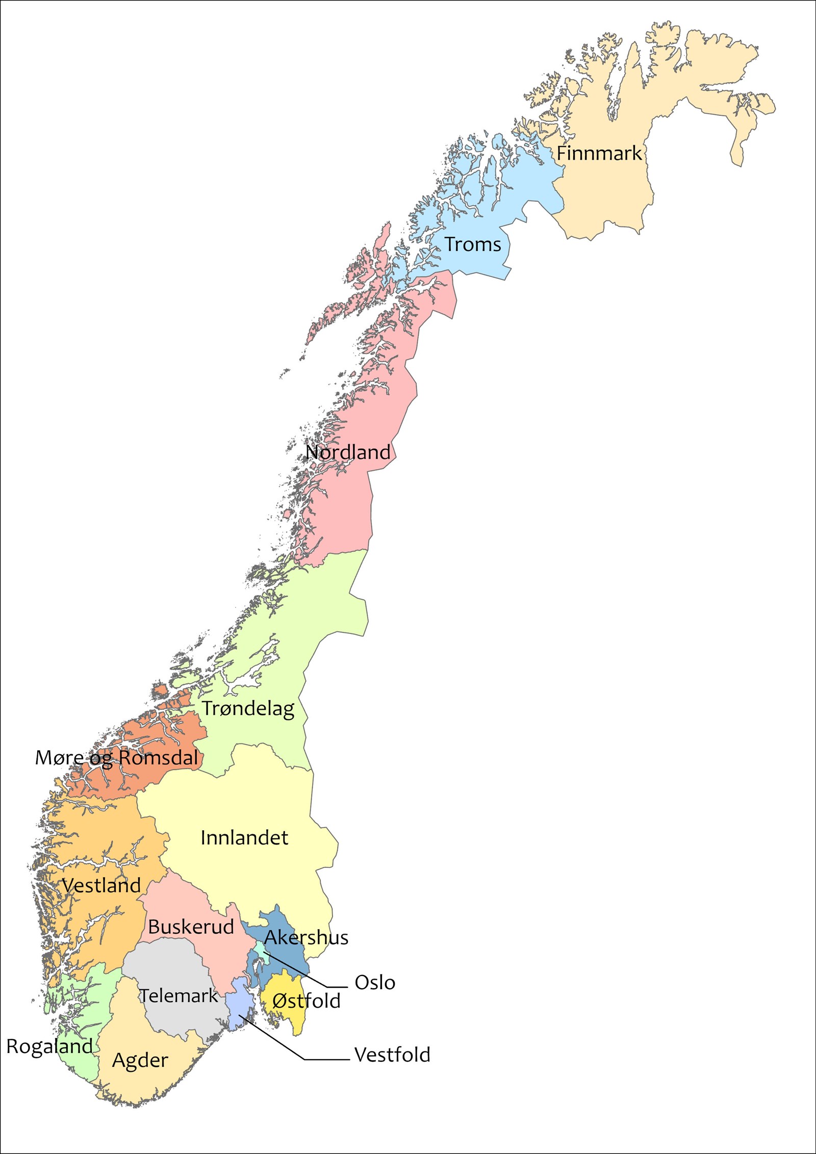
Dear NordNordWest, thank you for your excellent series of locator maps of Norway! I am writing to you to inform about what I believe is a minor error. You see, the former municipality of Rømskog no longer belongs to Østfold, but was merged with Aurskog‐Høland in 2020, and thus belongs to Akershus today. See this link for reference. Yours sincerely, VulpesVulpes42 (talk) 12:08, 1 January 2024 (UTC)
- Hello! You are right. I have to correct the maps. Regards, NNW 12:13, 1 January 2024 (UTC)
- Corrected. NNW 15:11, 1 January 2024 (UTC)
Can you update that file: Countries Georgia and Moldova are "Sichere Herkunftsstaaten" in Germany since December 2023.
--92.76.99.97 17:28, 1 January 2024 (UTC)
- It's updated now. NNW 20:11, 2 January 2024 (UTC)
Request for creation of Wolayita Zone map[edit]
Hi dear, could you create Wolayita Zone map including woredas and city administrations within it. Thank you. Kehaa (talk) 11:38, 2 January 2024 (UTC)
- That's impossible without any sources. NNW 20:13, 2 January 2024 (UTC)
- Ok, This can help you as a source. Thank you. Kehaa (talk) 13:16, 4 January 2024 (UTC)
- Even this map would be better but it seems to be quiet generalized. NNW 11:57, 5 January 2024 (UTC)
- Excuse me NNW, look this source together with previously I posted. The former one is updated and consists of 16 districts but it is not very clearly drawn. The current is very clear but it consists of 12 districts. If both are seen together, they may give some clue for sketching map. Thank you! Kehaa (talk) 18:39, 5 January 2024 (UTC)
- Even this map would be better but it seems to be quiet generalized. NNW 11:57, 5 January 2024 (UTC)
- Ok, This can help you as a source. Thank you. Kehaa (talk) 13:16, 4 January 2024 (UTC)
- The problem: en:Wolayita Zone#Administrative divisions says that there are 16 areas but no map I can find shows that much. NNW 18:25, 12 January 2024 (UTC)
Request for topographic maps of Chinese provinces[edit]
I have noticed that you've made location maps for every Chinese provinces, but of which some do not have maps with terrain. Could you please make topographic location maps for every provinces? 祝安 Kone718 (talk) 21:21, 5 January 2024 (UTC)
Request for update[edit]
Hello NNW, could you update this map with current addition of new administrative regions and flags therein. — Preceding unsigned comment added by Malaalaa (talk • contribs) 13:32, 23 January 2024 (UTC)
- Hello! I preferred all flags having the same width: Ethiopian regions map with flags.png. NNW 19:33, 27 January 2024 (UTC)
Request for update[edit]
Dear NordNordWest. The parliament of Azerbaijan has voted to reestablish the Aghdara Region (Azeri spelling: Ağdərə, previously known as the Mardakert District), which was abolished in 1992 [1] and was located within these borders (sorry, there is no full pre-1992 map for reference), stretching over three neighbouring districts. Would it please be possible to update the following maps?
- Azerbaijan's location map (by districts);
- Azerbaijan's location map (by economic zones), with Aghdara now part of the Karabakh economic zone.
If you have time, it would also be very useful to have a location map with the Aghdara District highlighted. Thank you! Parishan (talk) 03:25, 26 January 2024 (UTC)
- Azerbaijan adm location map.svg is updated now. Azerbaijan location map.svg is a bit strange: the last uploader changed both size and topic of that map. That's not my deal. NNW 21:10, 26 January 2024 (UTC)
- Many thanks! Any chances of changing these accordingly?
- Kalbajar District in Azerbaijan.svg
- Tartar District in Azerbaijan.svg
- Aghdam District in Azerbaijan.svg
- And perhaps creating an "Aghdara District in Azerbaijan.svg" map? I would appreciate it very much.
- Parishan (talk) 22:05, 26 January 2024 (UTC)
- I'll do it but not today. :o) NNW 22:08, 26 January 2024 (UTC)
- Thank you very much! Parishan (talk) 23:53, 26 January 2024 (UTC)
- A file for Aghdara is available now, some district maps (after asking the original uploader for permission) are updated. NNW 18:21, 29 January 2024 (UTC)
- Thank you again for your great work, NordNordWest! Parishan (talk) 15:06, 31 January 2024 (UTC)
- A file for Aghdara is available now, some district maps (after asking the original uploader for permission) are updated. NNW 18:21, 29 January 2024 (UTC)
Croatia[edit]
Hello NNW, I would like to say thank you very much for your big effort and contribution related to Croatian maps. Really appreciated. In pl.wiki this has enriched thousands of articles. I've created map modules and templates accordingly. Seeing how busy you are, I wouldn't dare to ask you for more, but if you decide to come back to this region one day, neighbouring Bosnia have 3 main entities (Federation of Bosnia and Hercegovina divided into 10 cantons, Republika Srpska and Brcko District), so within next months/years it shouldn't be that involving as Croatia was. Greetings, Mathieu Mars (talk) 20:28, 20 February 2024 (UTC)
- I definitely have to look for other requests before I start a new series of such maps. :o) NNW 07:17, 21 February 2024 (UTC)
Azerbaijani map update[edit]
Hello @NordNordWest! I would like to thank you for working on and updating the administrative map of Azerbaijan.
There's an official update to the map. Actually, the law was adopted on December 27, but almost nobody noticed that. The day Aghdara district established, some exclaves in Karabakh were removed and merged to the surrounding districts.
Here's the link to the law. I would be very glad to help if needed. Cheers, Toghrul R (talk) 14:48, 6 March 2024 (UTC)
- There is no map for these changes? NNW 17:35, 6 March 2024 (UTC)
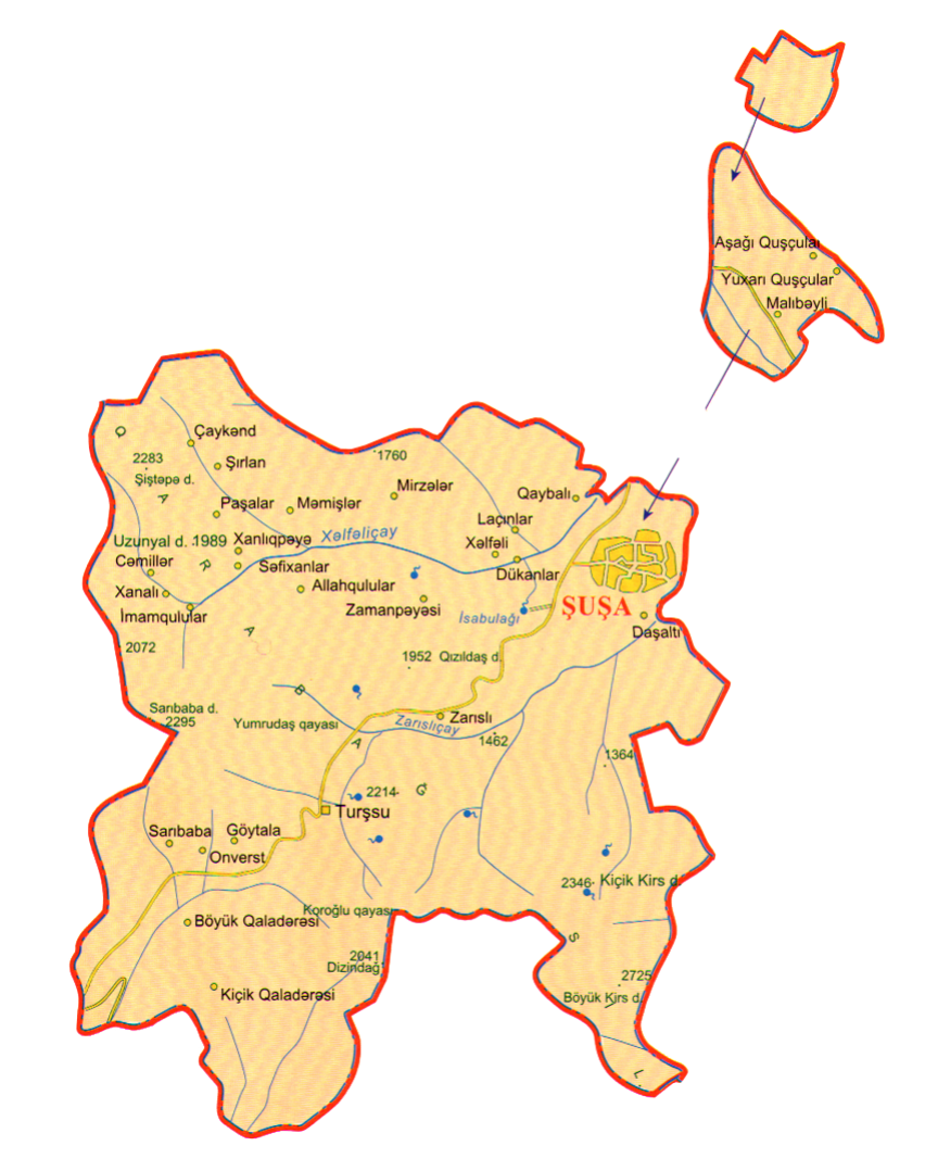
- @NordNordWest do you mean visualisation? Unfortunately, no. But I can provide the details. Most of the exclaves were removed.
- Article 2.
- Malıbəyli, Aşağı Quşçular and Yuxarı Quşçular were transferred to the surrounding Xocalı district. So they no longer are subordinated to Şuşa district. For instance in this detailed map and this file, villages away from mainland Şuşa are removed based on the law.
- Article 3 & 4.
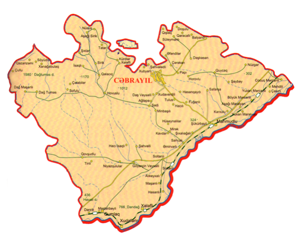
- Yuxarı Veysəlli and Divanalılar (the exclaves of Füzuli) were removed and the area was merged to Xocalı district. The villages can be seen from this file. Ağbaşlı was removed too, but it was too small and was not on the maps you made
- Article 5 & 6.
- Yuxarı Məzrə (the exclave of Cəbrayıl) was removed and the area was merged to Xocalı district. Can be seen here
- Article 7 & 8.
- Alıcan (at the rightmost of Laçın district and under Şuşa district) was removed and the area was merged to Xocalı district. Can be seen here
- Article 10.
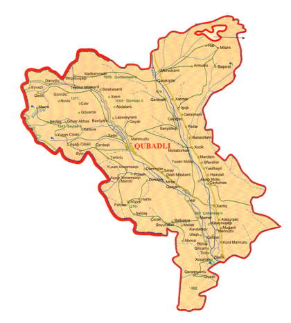
- The area of Xocavənd within Qubadlı was removed and merged to Qubadlı. Can be seen here Toghrul R (talk) 08:31, 7 March 2024 (UTC)
- PS: As it will affect many maps, I'll provide more details regarding the changes after checking them again Toghrul R (talk) 08:37, 7 March 2024 (UTC)
- I'll update soon. NNW 17:57, 12 March 2024 (UTC)
- Done. NNW 17:34, 10 April 2024 (UTC)
Request for map of "Hamburg S-Bahn"[edit]
Dear @NordNordWest!
Would it be possible to visualize the above-ground and underground sections of the route differently, like on the map of the “Hamburger Hochbahn” (see Topografischer Netzplan U-Bahn Hamburg - Hamburger Hochbahn – Wikipedia)?
Best regards! Ham-grisu (talk) 14:06, 12 March 2024 (UTC)
- Hello! Underground sections in Topografischer Netzplan S-Bahn Hamburg 2023.png are lighter now. NNW 17:56, 12 March 2024 (UTC)
Question about how you work[edit]
Dear NordNordWest.
I'm glad to watch your works. Your works have become an excellent example of location maps in Wikimedia for a last couple of decades. Even though I don't know SVG very well, further I have been thinking what can I do for community while I am learning Adobe Illustrator. If I have a mind to help others who work in Wikimedia, I think it would be better to ask for advice rather than drawing without benchmark.
- First, I'd like to ask if your question about how you work is okay. If not, you can skip the question below.
- What should I refer to? For Wikipedia, look at what has been written by others, and for the programming code, look at the code that has been written by others. It is how to learn. Then, what about SVG? What reference did you start with?
- In the future, can I update your work?
- Lastly, what was the driving force behind your steady activities?
Sorry for my clumsy English, and I hope you peaceful.
Best Regards. --호로조 (talk) 07:24, 19 March 2024 (UTC)
- Hello! It depends on the scale which data I use for a location map. Sometimes it is OpenStreetMap, sometimes it is VMAP data etc. VMAP is quite old data but for coastlines and rivers it is usually good enough. In some areas it is necessary to update the data. I don't use applications in which I have to program anything, it's a vector graphics editor, sometimes in combination with a GIS. I have learned in the last years that there are many users who are able to handle geographic data but lacking cartographic knowledge (as an example: see what happened to the amount of waterbodies in Ecuador location map.svg.) In other cases the size in pixels or the shown area were changed so all templates in the WPs were incorrect and the uploader didn't have thought about it. So I don't encourage anybody to update my location maps, especially as long as I do not know what he/she is able to do and knows about cartography. The rest is quite easy: it's a nice hobby. NNW 18:03, 20 March 2024 (UTC)
- Thank you thank 72.175.44.132 04:16, 18 April 2024 (UTC)
Karelo-Finnish SSR map[edit]
Hi, for the Karelo-Finnish SSR map you edited, can you readjust the border between Lithuania and Byelorussia? Lithuania received the Vilnius region from the USSR in 1939 and by the end of 1940 its eastern border was adjusted to what it is today with Byelorussia. Aimmella12 (talk) 19:57, 11 April 2024 (UTC)
- Hello! You will have to link the file. I don't know what you are talking about. NNW 20:08, 11 April 2024 (UTC)
File:Soviet Union - Karelo-Finnish SSR (1940).svg Aimmella12 (talk) 06:14, 12 April 2024 (UTC)
.svg)