Commons:Graphic Lab/Map workshop/Archive/2010
NLL and MLL Maps[edit]
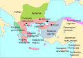
-
 MLL
MLL -
 MLL SVG
 -
 NLL
NLL -
 NLL SVG


Request: Make svg versions of these please. Thanks Yarnalgo (talk) 03:11, 14 January 2010 (UTC)
Graphist opinion(s): I did one of them Richardprins (talk) 21:30, 5 February 2010 (UTC)
- I made the other one aswell
- Thank you. --Yarnalgo (talk) 02:43, 6 February 2010 (UTC)
Mount Kenya Population map[edit]

Request: Remove border... Kintetsubuffalo (talk) 04:27, 28 February 2010 (UTC)
Graphist opinion(s):
First world[edit]

Request: Trim away blank area so displays larger... --Kintetsubuffalo (talk) 06:12, 14 March 2010 (UTC)
Graphist opinion(s):
![]() Done ZooFari 07:19, 14 March 2010 (UTC)
Done ZooFari 07:19, 14 March 2010 (UTC)
- Thank you! --Kintetsubuffalo (talk) 08:10, 14 March 2010 (UTC)
paleohisp[edit]

Request: Fix spelling of northeast... Kintetsubuffalo (talk) 03:21, 22 March 2010 (UTC)
Graphist opinion(s): Done. Kmusser (talk) 13:40, 6 April 2010 (UTC)
- Thank you! --Kintetsubuffalo (talk) 17:15, 6 April 2010 (UTC)
Football venues for the 2016 Summer Olympics[edit]
Request: Hi there. I tried to upload a map of Brazil showing the football competition venues for the 2016 Summer Olympics, File:Football venues for the 2016 Summer Olympics.svg, but it was different from File:Rio de Janeiro venues for the 2016 Summer Olympics.svg. Someone could standardize the map of Brazil using the same text formatting of the map of Rio? Regards; Felipe Menegaz 18:39, 28 March 2010 (UTC)
Graphist opinion(s):
![]() Request taken by Yarnalgo
Request taken by Yarnalgo
![]() Done Is that what you meant? --Yarnalgo (talk) 22:50, 5 April 2010 (UTC)
Done Is that what you meant? --Yarnalgo (talk) 22:50, 5 April 2010 (UTC)
- Yes! Thank you very much! Felipe Menegaz 16:34, 9 April 2010 (UTC)
Ionian Islands[edit]

Request: Please remove the derisive term FYROM, it's unnecessary and it violates NPOV as it denigrates an accepted UN member... other countries are unlabeled --Kintetsubuffalo (talk) 08:50, 4 April 2010 (UTC)
Graphist opinion(s):
![]() Done by Kmusser (talk · contribs). --Yarnalgo (talk) 22:24, 5 April 2010 (UTC)
Done by Kmusser (talk · contribs). --Yarnalgo (talk) 22:24, 5 April 2010 (UTC)
File:Bids for the 2016 Summer Olympics.svg[edit]
-
 Bids for the 2016 Summer Olympics

Request: There is a problem with the format of the text, could someone fix it? Felipe Menegaz 19:14, 9 April 2010 (UTC)
Graphist opinion(s):
- What's the problem? How do you want the text to look like? ZooFari 23:05, 9 April 2010 (UTC)
- Well, the text does not appear on Commons as it appears on Inkscape. Felipe Menegaz 22:19, 10 April 2010 (UTC)
- Use Arial for best results. The text won't ever look like the appearance in Inkscape, unless you want to upload a non-modifiable text version (see here. Blame the Wiki software :( ZooFari 22:33, 10 April 2010 (UTC)
- That is not true. It will show up like it does in Inkscape if you use one of the accepted SVG fonts (Arial is not an accepted font so it won't show up right on Commons). --Yarnalgo (talk) 00:39, 11 April 2010 (UTC)
- If you can show me one SVG example, you'll be my new best friend. ZooFari 01:14, 11 April 2010 (UTC)
- Thanks for User:ZooFari/Rendering. :) Cheers; Felipe Menegaz 17:09, 15 April 2010 (UTC)
- If you can show me one SVG example, you'll be my new best friend. ZooFari 01:14, 11 April 2010 (UTC)
- That is not true. It will show up like it does in Inkscape if you use one of the accepted SVG fonts (Arial is not an accepted font so it won't show up right on Commons). --Yarnalgo (talk) 00:39, 11 April 2010 (UTC)
- Use Arial for best results. The text won't ever look like the appearance in Inkscape, unless you want to upload a non-modifiable text version (see here. Blame the Wiki software :( ZooFari 22:33, 10 April 2010 (UTC)
- Well, the text does not appear on Commons as it appears on Inkscape. Felipe Menegaz 22:19, 10 April 2010 (UTC)
British India[edit]

Request: remove watermark... Kintetsubuffalo (talk) 17:40, 10 May 2010 (UTC)
Graphist opinion(s): can't see a watermark there? --DieBuche (talk) 22:35, 14 May 2010 (UTC)
- Top center of frame. --Kintetsubuffalo (talk) 02:54, 15 May 2010 (UTC)
- Done. --Richardprins (talk) 16:36, 23 May 2010 (UTC)
- Thank you! --Kintetsubuffalo (talk) 00:38, 24 May 2010 (UTC)
WAGGGS-WOSMWestHemMap-World.svg[edit]
Note: This request was moved from the Images to improve or create to the Map workshop. ZooFari 00:47, 17 December 2009 (UTC)
-
 change map perspective
 -
 according to this perspective, or blank map of the World "Pacific Ocean centered" at http://english.freemap.jp/world_e/8.html


Article(s): several on multiple Wikipedias...
Request: change map perspective of the first map to that of the second map. Thank you! -- Kintetsubuffalo (talk) 13:50, 3 October 2009 (UTC)
Editor opinion: see File:Pacific Blank Map (Mercator projection).svg - Begoon (Talk) 13:44, 8 June 2010 (UTC)
- New file now uploaded to File:WAGGGS-WOSM-Western Hemisphere.svg - Begoon (Talk) 15:27, 8 June 2010 (UTC)
- Fantastic, thank you!--Kintetsubuffalo (talk) 15:48, 8 June 2010 (UTC)
Eurasian Scout Region[edit]
Request: one island in the Aral Sea shows as green, should be purple... Kintetsubuffalo (talk) 16:48, 4 June 2010 (UTC)
Graphist opinion(s):
![]() Done poor island isn't even an island anymore. Kmusser (talk) 17:32, 8 June 2010 (UTC)
Thanks! --Kintetsubuffalo (talk) 17:32, 8 June 2010 (UTC)
Done poor island isn't even an island anymore. Kmusser (talk) 17:32, 8 June 2010 (UTC)
Thanks! --Kintetsubuffalo (talk) 17:32, 8 June 2010 (UTC)
Cantal département[edit]
-
 A map of (yet) unknown source and year showing département Cantal

Request: I request to remove the ugly red dot surrounding Trizac from the map as it clearly not belongs there. The removal of the wrong author and source (own work) information is another part of work. Martin H. (talk) 18:22, 11 June 2010 (UTC)
![]() Done: Thanks User:Richardprins for the work! It toke some time but I finaly found out the right name (for some reason I didnt read that it is an y and not a v in the engraver name...) and found the online source as well as some creator information. Thank you again very much. --Martin H. (talk) 22:41, 11 June 2010 (UTC)
Done: Thanks User:Richardprins for the work! It toke some time but I finaly found out the right name (for some reason I didnt read that it is an y and not a v in the engraver name...) and found the online source as well as some creator information. Thank you again very much. --Martin H. (talk) 22:41, 11 June 2010 (UTC)
File:Europe biogeography countries.svg[edit]

Request: this one is strange, it has excess blank space on top, left and bottom, but text is truncated on right, please fix: in addition remove framing border per MOS... Kintetsubuffalo (talk) 10:24, 19 July 2010 (UTC)
Graphist opinion(s):
I changed it. I made the text smaller and changed it to liberation sans, a font supported by commons. Richardprins (talk) 20:43, 19 July 2010 (UTC)
![]() Request taken by name: when you accept the request ;
Request taken by name: when you accept the request ;
![]() Done: when the request is done. -->
Done: when the request is done. -->
- Better than I had hoped, thank you!--Kintetsubuffalo (talk) 09:44, 20 July 2010 (UTC)
Argentina[edit]

Request: offshore islands should be white or purple only, not tan... Kintetsubuffalo (talk) 09:09, 26 July 2010 (UTC)
Graphist opinion(s): ![]() Done Kmusser (talk) 13:27, 3 August 2010 (UTC)
Done Kmusser (talk) 13:27, 3 August 2010 (UTC)
- One more left off the coast of 5. Thanks!--Kintetsubuffalo (talk) 13:42, 3 August 2010 (UTC)
- Got it. Kmusser (talk) 02:06, 5 August 2010 (UTC)
- Great, thank you!--Kintetsubuffalo (talk) 04:37, 5 August 2010 (UTC)
Centers of sword production[edit]
Note: This request was moved from the IIllustration workshop to the Map workshop. Ivan Akira (talk) 00:35, 27 July 2010 (UTC)
-
 Centers of sword production

Request: The image appears shifted in the preview. Please fix it. bamse (talk) 08:49, 26 July 2010 (UTC)
Graphist opinion(s): ![]() Done managed to do it myself. bamse (talk) 20:49, 29 July 2010 (UTC)
Done managed to do it myself. bamse (talk) 20:49, 29 July 2010 (UTC)

Request: Can someone draw free SVG map? The image shows final phase of w:First Serbian Uprising. Blue lines are Serbian fronts and green ones are Turkish. Names near those lines are names of front commanders. Gray box ih right upper corner with text Serbian (1833), should be removed Bojan Talk 04:42, 25 May 2010 (UTC)
Graphist opinion(s):
Wood turtle distribution[edit]

Article(s): Wood turtle, on Wikipedia.
Request: I need a distribution map that looks similar to the one provided by this exceptional reference: this. The one on the second page here is also good (minus all the writing and symbols). I would like to be cropped somewhere along the state of Montana. This would be a great help. Thanks in advance.--NYMFan69-86 (talk) 00:04, 26 May 2010 (UTC)
- I recently made this one, however, it doesn't look that great.--NYMFan69-86 (talk) 01:58, 1 June 2010 (UTC)
Graphist opinion:
- Already made at Wikipedia Graphic Lab: File:Wood turtle distribution.svg. Marking this as resolved. --ZooFari 23:36, 6 February 2011 (UTC)
Byzantium1204-sr.svg[edit]
-
 Map in Serbian

Request: Can sombedy fix this image (the black rectangle, line break)? And change font into something more readable, please Bojan Talk 23:15, 20 September 2010 (UTC)
Graphist opinion(s): I was able to get the black rectangle. Kmusser (talk) 17:36, 22 September 2010 (UTC)
Thanks. -- Bojan Talk 19:26, 22 September 2010 (UTC)
[edit]
-
 Navajo language map of the Navajo Nation

Would someone mind changing the Navajo state names into English and save this as a new file (like NavajoNationMapEnglish.svg) so that we have this map in English? The one to the northwest is Utah, the one to the Southwest is Arizona, the one to the southeast is New Mexico, and the one to the northeast is Colorado. Thank you WhisperToMe (talk) 14:05, 25 September 2010 (UTC)
Graphist opinion(s):
![]() Done:
Done:  File:NavajoNation map en.svg Seb az86556 (talk) 20:30, 25 September 2010 (UTC)
- Thank you very much :) WhisperToMe (talk) 22:15, 25 September 2010 (UTC)
Translating SVG map files in Italian[edit]
Hi, i'm an italian user interested in translating mpas in my own language. I yet done a trial with

, but source and author didn't work well, i probably made a mistake in compiling format or in choosing licence. I was in trouble in uploading files using "derivativeFX", so i tried with "main upload form".
Should someone explain me the right way to upload files like theese? Thanks.Ciaurlec (talk) 17:59, 18 October 2010 (UTC)
- It was a simple wikicode error that caused the author and source fields to not work. Namely, in the description field, the {{It}} template was not closed properly. See the changes I made here. — Huntster (t @ c) 22:44, 18 October 2010 (UTC)
- Nice! Thanks you.Ciaurlec (talk) 13:11, 19 October 2010 (UTC)
North Africa (orthographic projection)[edit]

-
![[North Africa] orthographic projection](https://upload.wikimedia.org/wikipedia/commons/thumb/8/86/Africa_%28orthographic_projection%29.svg/120px-Africa_%28orthographic_projection%29.svg.png) [North Africa] orthographic projection
[North Africa] orthographic projection -
 Morocco
 -
 Tunisia
 -
 Egypt
Egypt -
North Africa
-
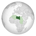 Libya example within North Africa region
![[North Africa] orthographic projection](/wiki/File:Africa_(orthographic_projection).svg)
.svg)
.svg)
.svg)
.svg)
Article(s): North_Africa, Morocco, Algeria, Tunisia, Libya, Egypt,
Request: Please create a North Africa centered orthographic projection so I can create/improuve the orthographic projections for the related states. --Flad (talk) 15:16, 9 January 2010 (UTC)
Graphist opinion:
- Not sure if you're still interested in this, but I've done some new orthographic projections, centred on Libya (i.e. more specifically 'North Africa'). The countries are grouped by their 3-letter ISO codes, so it's a fairly simple matter of changing fill and stroke after searching for the country code in the XML editor. Gringer (talk) 02:42, 26 September 2010 (UTC)
- That what i was asking for, thanks a lot. --Flad (talk) 13:39, 10 December 2010 (UTC)
Bus lines map[edit]
-
 Apeldoorn map

Request: Correction of some location names:
- "Rijks-Kantoeren" → "Rijkskantoren"
- "Sprenklaar" → "Sprenkelaar"
- "Rievierenkwartier" → "Rivierenkwartier"
- "Lukas Ziekenhuis" → "Gelre Ziekenhuizen Lukas"
- General: break words with hyphens
Apdency (talk) 18:47, 3 August 2010 (UTC)
Graphist opinion(s):
![]() Done this things:
Done this things:
- "Rijks-Kantoeren" → "Rijkskantoren"
- "Sprenklaar" → "Sprenkelaar"
- "Rievierenkwartier" → "Rivierenkwartier"
- "Lukas Ziekenhuis" → "Gelre Ziekenhuizen Lukas"
- Modified size of image
--Robot8A (talk) 08:11, 29 August 2011 (UTC)
- This section was archived on a request by: --maxxl2
 - talk 18:02, 26 February 2013 (UTC)
Map correction and update.[edit]
Request: Please update and correct the corresponding map in the article [1]. For example in the corresponding map the state of Iran is shown in red while actually it must be in brown and UK should be in red and it is in brown. Thankyou. 116.71.213.157 13:04, 11 September 2010 (UTC)
Graphist opinion(s):
- This section was archived on a request by: --maxxl2 - talk 18:10, 26 February 2013 (UTC)
NCAA D1 Lacrosse map[edit]
-
 Map of NCAA Division I lacrosse schools

Request: Convert to svg please and make somewhat readable. Also add Mercer University to the map (located in Macon, Georgia). Thanks Yarnalgo (talk) 22:20, 5 April 2010 (UTC)
- Also, conferences are not up to date. See College lacrosse for current conferences. --Yarnalgo (talk) 19:37, 6 April 2010 (UTC)
Graphist opinion(s):
![]() Done: File:Map - College Lacrosse - all men's D-I locations.svg. A lot more schools have added lacrosse than you indicated. =) As an added bonus, the colors match (where appropriate) the colors on the college hockey maps. Powers (talk) 02:14, 5 April 2011 (UTC)
Done: File:Map - College Lacrosse - all men's D-I locations.svg. A lot more schools have added lacrosse than you indicated. =) As an added bonus, the colors match (where appropriate) the colors on the college hockey maps. Powers (talk) 02:14, 5 April 2011 (UTC)
- Okay, mostly done. I'm still trying to remove a phantom black rectangle (the remnants of Alaska and Hawaii, I believe). I'll have to pick it up later. Powers (talk) 02:20, 5 April 2011 (UTC)
- Okay, fixed that problem. I'll replace it within the article. Powers (talk) 15:24, 5 April 2011 (UTC)
- Okay, mostly done. I'm still trying to remove a phantom black rectangle (the remnants of Alaska and Hawaii, I believe). I'll have to pick it up later. Powers (talk) 02:20, 5 April 2011 (UTC)
- This section was archived on a request by: Goran tek-en (talk) 18:13, 10 January 2014 (UTC)
Map of Newtownabbey Borough Council, NI.[edit]
Request: Do something with them... Jas1 (talk) 13:06, 19 May 2010 (UTC)
Graphist opinion(s):
- Please state what you want changed on which pictures--DieBuche (talk) 14:07, 19 May 2010 (UTC)
- This section was archived on a request by: Goran tek-en (talk) 18:12, 10 January 2014 (UTC)
UTA Flight 772 map, request for Arabic + French[edit]
-

-
 In French
 -
 In Arabic


Request: Would it be alright if someone made versions of this map in French and Arabic? WhisperToMe (talk) 01:22, 20 November 2010 (UTC)
 Done French. --Robot8A (talk) 17:50, 1 November 2011 (UTC)
- Done Arabic. If there's a translation mistake, please tell me. --Robot8A (talk) 18:18, 1 November 2011 (UTC)
- This section was archived on a request by: Goran tek-en (talk) 18:10, 10 January 2014 (UTC)
Okinawa[edit]

Request: move inset to actual position. Map doesn't really help show where Okinawa is. The prefecture is highlighted on the inset only, and there's nothing to indicate where the inset is located relative to the main map. If you don't already know where Okinawa is, this map isn't really going to help... Kintetsubuffalo (talk) 15:34, 23 June 2010 (UTC)
Graphist opinion(s):
@Kintetsubuffalo: Very old request time to do something. ![]() Request taken by name --Goran tek-en (talk) 19:42, 11 February 2014 (UTC)
Request taken by name --Goran tek-en (talk) 19:42, 11 February 2014 (UTC)
- I have made a draft now;
- [2 steps]
- Give me feedback on it. --Goran tek-en (talk) 20:14, 12 February 2014 (UTC)
- Unusual but thanks for your hard work! Let me make a mockup of what I have in mind and send it.--Kintetsubuffalo (talk) 03:07, 15 February 2014 (UTC)
- @Kintetsubuffalo: I will do one version more like your base map but there are some questions;
- There is a color scheme which is as a "standard" and I have used that in my draft. Do you want colors like yours for some special reason?
- I didn't put in lat long as I can't see any reason to have them there. Do you specifically want them?
- If I don't put in an enlarged map of Okinawa it's hard to tell what it looks like. Do you not want an enlarged section?
- Get back to me on this, thanks. --Goran tek-en (talk) 13:47, 16 February 2014 (UTC)
- @Kintetsubuffalo: I will do one version more like your base map but there are some questions;
- Unusual but thanks for your hard work! Let me make a mockup of what I have in mind and send it.--Kintetsubuffalo (talk) 03:07, 15 February 2014 (UTC)
- I really like your version and prefer it for other things! But the standard for Japanese prefectural --Kintetsubuffalo (talk) 09:18, 17 February 2014 (UTC)locator maps is the one above, with those colors and the lat long lines. For a --Kintetsubuffalo (talk) 09:18, 17 February 2014 (UTC)locator map such as this, the details don't need to be great. But I do want you to upload your superior map for other uses, too!--Kintetsubuffalo (talk) 09:18, 17 February 2014 (UTC)
- @Kintetsubuffalo: Now you can look at a draft and give me feedback on it.
- Do you want me to upload it over the existing one when it's done?
- Eventually I will need the following for the other zoomed version;
- Name of the file
- Description
- Category/ies
- to be able to upload it as a new file. --Goran tek-en (talk) 11:46, 17 February 2014 (UTC)
- I haven't received the feedback or info I asked for so I have now uploaded the two versions;
- If you want anything changed or so just contact me, thanks. --Goran tek-en (talk) 18:53, 1 March 2014 (UTC)
- @Kintetsubuffalo: Now you can look at a draft and give me feedback on it.
![]() Done
Done
- Great, thank you!--Kintetsubuffalo (talk) 11:44, 2 March 2014 (UTC)
- This section was archived on a request by: Goran tek-en (talk) 18:53, 1 March 2014 (UTC)
Redrawing of Mass Rapid Transit (Singapore) system map[edit]
-
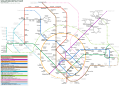 Really impressive SVG map of Singapore MRT/LRT System

.svg)
_2.svg)
Request: Is it possible for you to redraw this map so that it is not a derivative work of this website? (Note that there are some new train lines, so you will have to refer to the website for the latest version of the system.) — Cheers, JackLee –talk– 16:11, 21 June 2010 (UTC)
Anybody able to help? — Cheers, JackLee –talk– 12:22, 27 July 2010 (UTC)
The original graphic has been deleted as it is a copyright violation, but if anyone can produce a redrawn map based on the one on the website that is not too similar, that would be great. — Cheers, JackLee –talk– 08:33, 26 September 2010 (UTC)
Graphist opinion(s):
- @Jacklee: This map, created in 2014, appears to be complete when compared with the current system map. Cheers, Mliu92 (talk) 18:00, 3 July 2015 (UTC)
- This section was archived on a request by: Storkk (talk) 12:44, 5 August 2015 (UTC)
- @Jacklee: While this isn't the original topic, are you interested in having Tamil and/or Malay versions of this map? If so I can have people make keys so these versions are made. (Mandarin versions already exist) WhisperToMe (talk) 11:45, 12 August 2015 (UTC)