Category:Maps of American Samoa
Jump to navigation
Jump to search
Countries of Oceania: Australia · Fiji · Federated States of Micronesia · Kiribati · Marshall Islands · Nauru · New Zealand · Palau · Papua New Guinea · Samoa · Solomon Islands · Tonga · Tuvalu · Vanuatu
Other areas: American Samoa · Clipperton Island · Cocos (Keeling) Islands · Cook Islands · French Polynesia · Guam · Hawaii · New Caledonia · Niue · Norfolk Island · Northern Mariana Islands · Pitcairn Islands · Tokelau · Wallis and Futuna – Partly: British overseas territories · Overseas France · Indonesia · French Southern and Antarctic Lands · United States Minor Outlying Islands
Other areas: American Samoa · Clipperton Island · Cocos (Keeling) Islands · Cook Islands · French Polynesia · Guam · Hawaii · New Caledonia · Niue · Norfolk Island · Northern Mariana Islands · Pitcairn Islands · Tokelau · Wallis and Futuna – Partly: British overseas territories · Overseas France · Indonesia · French Southern and Antarctic Lands · United States Minor Outlying Islands
States of the United States: Alabama · Alaska · Arizona · Arkansas · California · Colorado · Connecticut · Delaware · Florida · Georgia · Hawaii · Idaho · Illinois · Indiana · Iowa · Kansas · Kentucky · Louisiana · Maine · Maryland · Massachusetts · Michigan · Minnesota · Mississippi · Missouri · Montana · Nebraska · Nevada · New Hampshire · New Jersey · New Mexico · New York · North Carolina · North Dakota · Ohio · Oklahoma · Oregon · Pennsylvania · Rhode Island · South Carolina · South Dakota · Tennessee · Texas · Utah · Vermont · Virginia · Washington · West Virginia · Wisconsin · Wyoming – Washington, D.C.
insular area of the United States: American Samoa · Guam · Northern Mariana Islands · Puerto Rico · United States Virgin Islands – United States Minor Outlying Islands: Baker Island · Howland Island · Jarvis Island · Johnston Atoll · Kingman Reef · Midway Atoll · Navassa Island · Palmyra Atoll · Wake Island
insular area of the United States: American Samoa · Guam · Northern Mariana Islands · Puerto Rico · United States Virgin Islands – United States Minor Outlying Islands: Baker Island · Howland Island · Jarvis Island · Johnston Atoll · Kingman Reef · Midway Atoll · Navassa Island · Palmyra Atoll · Wake Island
Wikimedia category | |||||
| Upload media | |||||
| Instance of | |||||
|---|---|---|---|---|---|
| Category combines topics | |||||
| American Samoa | |||||
United States territory in the Pacific Ocean    .svg)  | |||||
| Pronunciation audio | |||||
| Instance of |
| ||||
| Part of |
| ||||
| Named after | |||||
| Location |
| ||||
| Located in or next to body of water | |||||
| Capital | |||||
| Legislative body |
| ||||
| Executive body | |||||
| Highest judicial authority |
| ||||
| Official language | |||||
| Anthem | |||||
| Currency | |||||
| Head of government | |||||
| Has part(s) |
| ||||
| Inception |
| ||||
| Highest point |
| ||||
| Population |
| ||||
| Area |
| ||||
| Elevation above sea level |
| ||||
| Top-level Internet domain | |||||
| Different from | |||||
| Maximum temperature record |
| ||||
| Minimum temperature record |
| ||||
| official website | |||||
 | |||||
Subcategories
This category has the following 9 subcategories, out of 9 total.
*
C
L
P
S
T
Pages in category "Maps of American Samoa"
The following 2 pages are in this category, out of 2 total.
Media in category "Maps of American Samoa"
The following 47 files are in this category, out of 47 total.
-
 1950 Census Enumeration District Maps - American Somoa -ED 1-1-5, ED 2-1-8 - NARA - 75639627.jpg 13,286 × 11,887; 14.57 MB
-
 American Samoa Counties2.png 1,207 × 827; 12 KB
-
 American Samoa map.png 472 × 586; 10 KB
-
 American Samoa mk.png 500 × 500; 20 KB
-
 American Samoa villages.png 2,112 × 1,632; 69 KB
-
 AS01 109.png 638 × 379; 18 KB
-
 ECDM 20160426 World SevereWeather.pdf 1,625 × 1,125; 577 KB
-
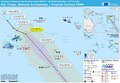
 ECDM 20180430 South-Pacific TC-Season.pdf 2,479 × 1,754; 1,024 KB
-
 ECDM 20190227 TC POLA.pdf 1,625 × 1,125; 560 KB
-
 ECDM 20191212 SAMOA Measles.pdf 1,625 × 1,125; 467 KB
-
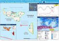
 ECDM 20200117 TC TINO.pdf 1,625 × 1,125; 616 KB
-
 ECDM DailyMap 20180212 TC GITA.pdf 2,479 × 1,754; 898 KB
-
 Location map American Samoa (central).png 841 × 882; 179 KB
-
 Manua Islands.jpg 726 × 394; 130 KB
-
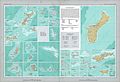
 Map of American Samoa's Marine Sanctuary -a.jpg 734 × 991; 227 KB
-
 MapOfManua NPS.png 556 × 376; 253 KB
-
 MapOfOfu-Olosega NPS.png 556 × 285; 271 KB
-
 MapOfTau NPS.png 556 × 355; 414 KB
-
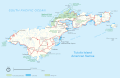 MapOfTutuila-American-Samoa.gif 3,033 × 1,968; 321 KB
-
 MapOfTutuila-American-Samoa.png 3,033 × 1,968; 338 KB
-
 National Atlas of the USA 1970 - Pacific Outlying Areas.jpg 4,170 × 2,836; 2.04 MB
-
 NMS of American Samoa map.jpg 734 × 991; 95 KB
-
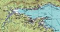 Pago Pago Harbor.jpg 1,260 × 677; 222 KB
-
 PAT - American Samoa.gif 850 × 750; 59 KB
-
 Plan de l'Archipel des Navigateurs.jpg 10,357 × 7,143; 10.23 MB
-
 Rose and Sand Islands.jpg 209 × 198; 53 KB
-
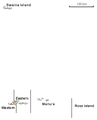
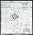
 Rose Atoll map.jpg 1,240 × 902; 191 KB
-
 Rose Atoll NOAA chart.jpg 1,211 × 1,275; 394 KB
-
 Samoa Cram Map 1896.jpg 2,165 × 1,621; 787 KB
-
 Samoa geologic map.png 1,350 × 592; 171 KB
-
 Samoa Islands 2002 mk.PNG 709 × 418; 33 KB
-
 Samoa islands 2002.gif 710 × 418; 46 KB
-
 Samoa islands 2002.png 709 × 418; 52 KB
-
 Samoa Islands 2002.PNG 709 × 418; 17 KB
-
 Samoa-West-East united samoa.png 2,879 × 761; 89 KB
-
 Second Samoan Civil War.gif 996 × 623; 10 KB
-
 Splashdown 2.png 657 × 400; 76 KB
-
 Swains island 1970.jpg 221 × 196; 20 KB
-
 Swains Island map.jpg 1,240 × 902; 184 KB
-
 Swains Island.jpg 211 × 183; 52 KB
-
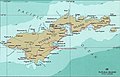 Tutuila Island.jpg 814 × 519; 188 KB
-
 Tutuila Locator.jpg 237 × 120; 32 KB
-
 Tutuila.jpg 570 × 547; 58 KB
-
 Txu-oclc-23029825-aunuu island-1989.jpg 715 × 546; 294 KB
-
 US -American Samoa.png 500 × 500; 3 KB
-
 Vailoa Map.jpg 358 × 381; 30 KB
-
 Villages of American Samoa.png 1,100 × 566; 25 KB


.png)


