User talk:Uwe Dedering
|
Our first steps tour and our frequently asked questions will help you a lot after registration. They explain how to customize the interface (for example the language), how to upload files and our basic licensing policy (Wikimedia Commons only accepts free content). You don't need technical skills in order to contribute here. Be bold when contributing and assume good faith when interacting with others. This is a wiki. More information is available at the community portal. You may ask questions at the help desk, village pump or on IRC channel #wikimedia-commons (webchat). You can also contact an administrator on their talk page. If you have a specific copyright question, ask at the copyright village pump. |
|
This message was added automatically by Nikbot, if you need some help about it, ask its master (Filnik) or go to the Commons:Help desk. --Filnik 22:02, 16 February 2010 (UTC)
Borders between Russia and Japan on your map is completely incorrect, because there is no border between Urup and Iturup. All Kurils are de jure and de facto Russian. It does not matter that Japan claimed some of the Russian Kuril Islands. We must show only the existing borders on all maps.
http://www.maps.com/map.aspx?cid=1425,1503&pid=11035 (Click to Zoom)
http://www.maps.com/map.aspx?cid=1425,1498&pid=11057 (Click to Zoom)
http://www.geoatlas.com/maps/countries/asia/russia/images/r02pol.gif?Lang=undefined&View=undefined
So please remove non-existent border from the Location map of Russia or use my version. Andrey Isakov (talk) 12:44, 29 April 2010 (UTC)
- You are wrong. See File:Demis-kurils-russian names.png and en:Kuril Islands dispute. Do not try to enforce the view of one nation in wikipedia. Uwe Dedering (talk) 15:30, 29 April 2010 (UTC)
- Am I wrong? In what? You do not agree with the fact that all the Kuril Island are Russian since 1945? I do not see any problems with File:Demis-kurils-russian names.png. This map shows all the historical borders between Russia and Japan. So we must use the last one (since 1945). Andrey Isakov (talk) 06:07, 30 April 2010 (UTC)
- For a disputed map, summarize the factual problems on the corresponding talk page, citing reliable sources, add {{Disputed diagram}} to its description, and, if you wish, create another map with your corrections, citing sources, and upload it under another name. Do not upload the version you prefer over the one you object to, please. Walter Siegmund (talk) 15:48, 29 April 2010 (UTC)
- Thank you for the help with the template {{Disputed diagram}}. Andrey Isakov (talk) 06:07, 30 April 2010 (UTC)
"No new arguments"? See Talk page. Andrey Isakov (talk) 16:10, 27 July 2010 (UTC)
Hi. Thanks for your offer to help with the IUCN red list project. Please note that I am still waiting for them to send a permission to OTRS, before I start uploading maps to Commons. What software are you using? Cheers, GoEThe (talk) 11:51, 22 June 2010 (UTC)
- Selfmade software, using for reading shapefiles en:GeoTools. Uwe Dedering (talk) 20:55, 22 June 2010 (UTC)
- Nice! Is it able to produce the maps in a (semi-)automated way? Can it zoom in to the necessary area? And use inset maps to indicate where the zoomed in part is in the world? The website has all the distribution maps in only a few shapefiles (by taxonomic group). Is this a problem for your software? I was able to find a script in ArcGis that splits the shapefiles by the description in an attribute field. Cheers, GoEThe (talk) 10:23, 23 June 2010 (UTC)
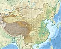
About File:China edcp location map.svg[edit]
I've realized it will approach some sensitive political issues if I ask you about this proposal~
However, I still would like to ask you to alter different colours between Taiwan and mainland China. As the PRC has never effectively ruled Taiwan since it was founded, in this map which shows on no dispute and imply this island as a part of them in the same appearance. I am afraid I cannot accept this practice and it obviously violates impartial viewpoint in wikipedia. At this point I must say I don't really mean to criticize you, but I really expect that you can give consideration for every standview.
In spite of this, I am able to accept if the picture shows differentiation on dispute. Maybe I can offer you some instances and you might deliberate for them ,such as this ![]() , and I think this is a good method to dissolve every kind of similar issue. If you'd like to communicate with me, you can use my discussion page, and I will be really delighted to see your reply.
--JOSH tw (talk) 13:38, 25 June 2010 (UTC)
, and I think this is a good method to dissolve every kind of similar issue. If you'd like to communicate with me, you can use my discussion page, and I will be really delighted to see your reply.
--JOSH tw (talk) 13:38, 25 June 2010 (UTC)
@Josh tw You are right, i will upload a new version with Taiwan colored like Karabach in the File:Azerbaijan_location_map.svg. ![]() Done Uwe Dedering (talk) 18:08, 5 July 2010 (UTC)
Done Uwe Dedering (talk) 18:08, 5 July 2010 (UTC)
I am really glad of your help and your reply, and I have already seen the fruits of your work; but I still consider that the display is a bit indistinctive as each colour are so close. For this reason, I attempted to modify a new uploading with distinct colour on Taiwan, the appearance of colour is C:12/M:8/Y:20/K:2 ; colour code:E4E4D0. You can recover it if you don't satisfy my work, but also tell me the reason. Whatever, I have to say every your works are really brilliant!--JOSH tw (talk) 20:09, 8 July 2010 (UTC)
- Don't change the color. This is not an isolated map. It is part of the location map project. See here: de:Wikipedia:Kartenwerkstatt/Positionskarten. All colors are the same in over 500 location maps. And you have destroyed the layers for inkscape. I will revert now. If you want a change, please ask first... Uwe Dedering (talk) 20:22, 8 July 2010 (UTC)
Frisia[edit]
Hey, thanks for your help with the svg, too bad the line is still there. Richardprins (talk) 21:10, 13 July 2010 (UTC)
- I tried everything... :-) Uwe Dedering (talk) 22:19, 13 July 2010 (UTC)
Disputed map[edit]
For a disputed map, summarize the factual problems on the corresponding talk page, citing reliable sources, add {{Disputed diagram}} to its description, and, if you wish, create another map with your corrections, citing sources, and upload it under another name. Thank you. Walter Siegmund (talk) 21:45, 16 July 2010 (UTC)
Hello,
Thank you for your reply. I did not know that I had removed the coastline; this was not done intentionally.
Thanks.
--AnonyLog (talk) 15:46, 19 September 2010 (UTC)
I didnt intend to remove the coastline. I added them back. I have coloured the parts of Kashmir controlled by Pakistan and China differently. --Ashwinikalantri (talk) 19:09, 17 January 2011 (UTC)
- This time you have destroyed the layers for inkscape. And please discuss the different colors before you change this map!. Uwe Dedering (talk) 16:12, 18 January 2011 (UTC)
- I wasn't aware that I was altering the layers. How do you edit the .svg file? I used Adobe Illustrator CS4.--Ashwinikalantri (talk) 19:16, 18 January 2011 (UTC)
- I use Inkscape, but it would in this case be possible to use a text editor. But do not change the colors again please, the wikipedia has to show a neutral point of view, not the pov of one country. Uwe Dedering (talk) 19:36, 18 January 2011 (UTC)
 Thank you. and lets discuss that.--Ashwinikalantri (talk) 23:58, 18 January 2011 (UTC)
- I use Inkscape, but it would in this case be possible to use a text editor. But do not change the colors again please, the wikipedia has to show a neutral point of view, not the pov of one country. Uwe Dedering (talk) 19:36, 18 January 2011 (UTC)
Dispute Resolution[edit]
Kindly join India Location map.svg to resolve the difference in the opinion. Thanks--Ashwinikalantri (talk) 17:11, 22 January 2011 (UTC)
About templates, maps and points[edit]
Hi Uwe, can you please point me to some information somewhere that would help me learn how to have one and the same svg map in a series of infobox templates (like a country with subdivisions) and then have an svg point/spot superimpose on it by the geo-coordinates given in one of the lines? I am trying to figure it out by following discussion histories all over, but I'm still nowhere. Thank you. Hoverfish (talk) 00:59, 5 November 2010 (UTC)
Yes, this is excellent. Thank you! Hoverfish (talk) 11:08, 5 November 2010 (UTC)
Tibetan diaspora location map[edit]
Hi Uwe, I am writting to you, as you made File:India_location_map.svg. Would it be possible to make File:Tibetan diaspora location map.svg showing India, Bhutan and Nepal in white ? I have suggested this here :[1]. Thanks for your help.--Rédacteur Tibet (talk) 17:10, 14 January 2011 (UTC)
Hello[edit]
Hey, where did you get this this terrain image from? [2], my guess is that you didn't create it. --Supreme Deliciousness (talk) 19:15, 21 January 2011 (UTC)
Your non neutral pov image[edit]
Hello, I noticed your map: [3]
That image is claiming that the Israeli occupied Golan is part of Israel. --Supreme Deliciousness (talk) 17:51, 27 January 2011 (UTC)
- Wow, i completly forgot that, because the borders were only for orientation for a historical map. I will correct the map in the next days. Uwe Dedering (talk) 20:32, 28 January 2011 (UTC)
Datei waterbasin map.jpg[edit]
Hi Uwe
Hab nach langer Inaktivität erst jetzt festgestellt, dass in die Datei auf wiki-commons die Flussbecken von Tocantins und Araguaia vertauscht sind (siehe Artikel Goiás). Richtig ist Rio Araguaia links, Tocantins rechts. Ich hoffe, du hast Lust dies zu korrigieren. Herzlichen Dank im Voraus! -- Oceco (talk) 20:25, 26 April 2011 (UTC)
About File:China edcp location map.svg (2, Yug)[edit]
-

-
 Support Geocoded File:China edcp relief location map.jpg (with paralleles and lattitudes)
 -

 Oppose China blank map.svg (political ; but unstate projection) : not geocoded
 -
 Oppose File:Macau locator map.svg, based on File:China blank map.svg.
Good colors for Politic map!! but : not geocoded -
 Oppose File:East Asia topographic map.png : not geocoded


_de.svg)
![[2]](https://en.wikipedia.org/wiki/File:Nepal_relief_location_map.jpg)
![[3]](https://commons.wikimedia.org/wiki/File:Palestine_base_map.svg)
- Hello,
- 1. A new set: since the current set of map is based upon File:China blank map.svg which haven't a clear projection/coordinates, it is need to set up a new set of maps for China. Your creations are more reliable as thus a good new basis ! So let's rool!
- 2. China map: I'm rather pro-Taiwanese independence, but this map is 'ok' for me since the file name use "China", not PRC nor ROC, and is thus correct.
- 3. PRC map (political): But, an accurate political version such as PRC vs ROC would need color differentiation. For colors, see: File:Macau locator map.svg
- 4. Relief location blank: I actually came to request you a blank relief location map, without parallels, without borders (borders can be retrieved from the SVG version if necessary). This background is need for historical maps, on which I contribute time by time. For such background, I encourage you to use the PD license.
- Regards, Yug 16:55, 5 July 2010 (UTC)
@Yug These two maps are not part of a china set. They are part of the location map project and you should know that. What do you think about a map like File:Azerbaijan_base_map.svg? Layers can easily be deleted or new layers can be added. Licence would be Creative Commons Attribution-ShareAlike 3.0. See also File:Azerbaijan_railway_map.svg. Uwe Dedering (talk) 17:39, 5 July 2010 (UTC)
- Hi Yug, I actually do have my difficulties to understand owhat you are trying to say or what you wish for. However, maybe you want to check out Category:SVG locator maps of China (location map scheme). I tried to take more than one view into account when it came to disputed areas.--TUBS
 12:59, 28 September 2011 (UTC)
- Hi Yug, I actually do have my difficulties to understand owhat you are trying to say or what you wish for. However, maybe you want to check out Category:SVG locator maps of China (location map scheme). I tried to take more than one view into account when it came to disputed areas.--TUBS
China (3) and Historical maps mapmaking[edit]
Hello Uwe, I'm today working again on an historical map. This time about 5th century BC's China. Historical maps are closely relate to topography. Also, I wish to share the following issues with you
- Soft display of borders: Using your topographic background, I will find myself forced to display the modern provinces borders. Historical maps ask to get rid off modern borders, which are irrelevant and misleading in these early times. It will be better for historical maps to start from a purely topographic background, without borders of parallels and meridians. It would help if you can provide a such purely topographic version of File:China edcp relief location map.jpg, and store parallels and meridians in the location map.
- Location map, code clean up : I'm looking into File:China edcp location map.svg's code. Nice ! Is is ok to change the some items' names ? I'm willing to set the 24 provinces polygons labels to their respective name, such id="Henan", id="Guangdong". Thus: 10m-admin-1-states-provinces-shp.1973 -> Yunnan. That will be easier to read.
Please let me know your opinion on this 2 issues *here*, and simply notice me on my talkpage. Yug (talk) 09:07, 23 May 2011 (UTC)
- Uwe, I'm collecting my previously done SVG layers : Chinese provinces names ; China topography ; China 5 BC ; China 609 ; China 742 ; China 1900 to covert them to your projection China edcp location map.svg. Please provide an another version of China_edcp_relief_location_map.jpg without borders, with very thin meridians and parallels, and with all landmass in natural colors (without white layer). So I can publish 5 maps set all based on you projection and georeferenced maps ; ) Yug (talk) 18:12, 25 May 2011 (UTC)
GIS sources for countries, borders, and waters ?[edit]
.png)
Hello Uwe, I'm trying to do maps by myself. I'm currently fighting with en:QGis, as you can see on the right side. So :
- which soft do you use ?
- which tutorial do you follow ? (link ?)
- what are your GIS data source for countries areas, borders, waters of File:China edcp location map.svg ? (link?)
regards ! Yug (talk) 08:30, 29 May 2011 (UTC)
- AGeneral questions moved to NNW's german talk page. Yug (talk) 17:20, 1 June 2011 (UTC)
Bitte prüfe das mal. Nix schlimmes aber könnte sein das da ein kleiner Fehler vorliegt. Danke.--TUBS![]() 12:32, 28 September 2011 (UTC)
12:32, 28 September 2011 (UTC)
 Done. Dank an NNW.--TUBS 07:33, 14 October 2011 (UTC)
Es fehlt eine Lizenz. Habe davon Derivate erstellt. Ich lizensiere diese unter GDFL und CC-by-SA-3.0. Bitte widerspreche dieser Lizenzwahl auf meiner Disk ausdrücklich, falls du dir eine andere Lizenz wünschst. Toll, wäre wenn du auch die File:Indonesia location map.svg mit GFDL und CC-by-SA nachlizensieren würdest - dann gebe es keine Probleme. --TUBS![]() 09:02, 29 September 2011 (UTC)
09:02, 29 September 2011 (UTC)
- Done Nach Rücksprache mit Commons:Forum#File:Indonesia_location_map.svg ist alles Done. Kurzfassung: war nicht dein Fehler. Eine IP hat die Lizenzen gelöscht.--TUBS 07:34, 14 October 2011 (UTC)
Bitte auch prüfen. Da fehlt glaub ich eine Provinz?--TUBS![]() 11:46, 29 September 2011 (UTC)
11:46, 29 September 2011 (UTC)
- {{erl.]}} Dank an NNW--TUBS 21:33, 24 October 2011 (UTC)
Carte TGV-fr.svg[edit]
Bonjour,
je suis un wikipédien novice et je ne sais pas créer/modifier des fichiers SVG comme on trouve beaucoup sur Wikipedia.
Or, je me désolé de voir la carte des LGV françaises ne plus indiqué aucun chantier de LGV alors qu'il n'y en a jamais eu autant de démarrés en même temps !
Aussi, je contacte tout les derniers contributeurs du fichier. Pouvez-vous m'aider à remédier à ce retard?

|
File:Freinsheim City Flag.svg has been listed at Commons:Deletion requests so that the community can discuss whether it should be kept or not. We would appreciate it if you could go to voice your opinion about this at its entry.
If you created this file, please note that the fact that it has been proposed for deletion does not necessarily mean that we do not value your kind contribution. It simply means that one person believes that there is some specific problem with it, such as a copyright issue. Please see Commons:But it's my own work! for a guide on how to address these issues. |
Fränsmer (talk) 23:12, 7 January 2013 (UTC)
Iran location map[edit]
Hi. Thanks for your great works for updating map of Iran and whole world! Could you make separate country path for Alborz and Tehran in File:Iran_location_map.svg? That would be so useful. −ebraminiotalk 11:32, 29 January 2013 (UTC)
|
|
File:Iran location map.svg has been listed at Commons:Deletion requests so that the community can discuss whether it should be kept or not. We would appreciate it if you could go to voice your opinion about this at its entry.
If you created this file, please note that the fact that it has been proposed for deletion does not necessarily mean that we do not value your kind contribution. It simply means that one person believes that there is some specific problem with it, such as a copyright issue. Please see Commons:But it's my own work! for a guide on how to address these issues. |
37.254.202.239 12:52, 27 September 2013 (UTC)
Hi Dedering! I noticed that you made the above map. If it's okay with you, may I ask for your assistance to also create Location maps for Sri Lanka by Province (cropped to province, while using the same colour theme) as well? The existing location maps are all non-cropped versions, with colours not used commonly in more current location maps. Hoping to hear from you soon! Best regards, Rehman 06:33, 5 April 2015 (UTC)
|
|
File:Usa edcp location map.svg has been listed at Commons:Deletion requests so that the community can discuss whether it should be kept or not. We would appreciate it if you could go to voice your opinion about this at its entry.
If you created this file, please note that the fact that it has been proposed for deletion does not necessarily mean that we do not value your kind contribution. It simply means that one person believes that there is some specific problem with it, such as a copyright issue. Please see Commons:But it's my own work! for a guide on how to address these issues. |
139.141.247.205 06:26, 27 April 2015 (UTC)
Hello ! Thank you for making this Democratic Republic of the Congo location map ! However, there are now 26 provinces instead of 11 since 2015. You can see this link : [4]. The map in this link is correct but the province of Lulua (center of the map) has a new name : Kasaï-Central.
Could you please modify the SVG map with the 26 new provinces ?
Thank you very much. Mightymights (talk) 15:51, 30 January 2016 (UTC)
Iran location map.svg[edit]
Hi.may I ask why the three (most important) islands of iran (Abu Musa & Greater and Lesser Tunbs) aren't Shown in this map?it's caused quite a controversy in Persian Wikipedia!Tnx--Arian Ar (talk) 13:12, 24 March 2016 (UTC)
File:The_Search_for_Malaysia_Airlines_Flight_370_-_Initial_search_areas_(Southeast_Asia)_de.svg[edit]
Hallo Uwe, in der Datei ist ein Fehler. Es muss lauten "Letzte Ortung (mit Militärradar), 370 km von der Insel Penang entfernt." Gruß, — Elvaube ?! 18:42, 14 June 2016 (UTC)
Arctic Ocean relief location map[edit]
Hi ! Am new in Wikimedia Commons,
Am looking for this map in SVG file, It's avalable in PNG only... Can you Upload it ?
https://commons.wikimedia.org/wiki/File:Arctic_Ocean_relief_location_map.png — Preceding unsigned comment added by Alienlarevanche (talk • contribs) 19:13, 22 February 2017 (UTC)
Thanks :)
Hichem — Preceding unsigned comment added by Alienlarevanche (talk • contribs) 19:12, 22 February 2017 (UTC)
A barnstar for you![edit]

|
The Graphic Designer's Barnstar |
| Dir sei dieser Orden verliehen, für die politische, flächengetreue und mit passendem Projektionszentrum erstellte Südamerikakarte - und v.a. dafür, dass Du die Projektionsart und alle weiteren Quellendaten vorbildlich angegeben hast! Dan-yell (talk) 20:32, 10 April 2017 (UTC) |
|
|
File:S-Bahn Rhein-Main Map.svg has been listed at Commons:Deletion requests so that the community can discuss whether it should be kept or not. We would appreciate it if you could go to voice your opinion about this at its entry.
If you created this file, please note that the fact that it has been proposed for deletion does not necessarily mean that we do not value your kind contribution. It simply means that one person believes that there is some specific problem with it, such as a copyright issue. Please see Commons:But it's my own work! for a guide on how to address these issues. |
79.251.133.235 21:34, 1 June 2017 (UTC)
Geographical features map of Tohoku Region[edit]
Hello, Uwe Dedering.
I made geographical features map of Tohoku Region in Japan(File:Geofeatures map of Tohoku Japan ja.svg), as derivative work of your works(File:Japan NorthernHonshu simplemap-de.svg). I really appreciate it.
If there are any problems about license or other, please let me know.--Peka (talk) 06:44, 28 December 2017 (UTC)
Correction requests[edit]
Hello, Uwe Dedering.
There are mistakes in these maps which have not been undone. Would you correct them?
In both File:Christian States.svg and File:State Religions.svg, El Salvador is wrongly included, which needs to be removed because it doesn't have a state religion. Article 26 of the Constitution of El Salvador does not declare the Catholic Church as a state religion: "The juridical personality of the Catholic Church is recognized. The other churches may obtain recognition of their personality in conformity with the law". Source: http://confinder.richmond.edu/admin/docs/ElSalvador1983English.pdf
In File:Map of state religions.svg, Georgia is wrongly included, which needs to be removed because it doesn't have a state religion. Section 1 of Article 9 of the Constitution of Georgia does not declare the Georgian Orthodox Church as a state religion: "The state shall declare complete freedom of belief and religion, as well as shall recognise the special role of the Apostle Autocephalous Orthodox Church of Georgia in the history of Georgia and its independence from the state." Source: http://www.parliament.ge/files/68_1944_951190_CONSTIT_27_12.06.pdf In the same map, Zambia is also is wrongly included, which needs to be removed because it doesn't have a state religion. The preamble of the Constitution of Zambia declares Zambia as a "Christian nation", but does not declare an official state religion. Source: http://www.parliament.gov.zm/sites/default/files/documents/amendment_act/Constitution%20of%20Zambia%20%20%28Amendment%29%2C%202016-Act%20No.%202_0.pdf
In File:Paises con mayoría cristiana.svg Nakchivan needs to be painted in pink, because it is an exclave of Azerbaijan, and like Azerbaijan as a whole, Nakchivan doesn't have a Christian majority.
Your sincerely, Artoxx (talk) 20:39, 11 February 2018 (UTC).
File:China edcp location map.svg requires updating[edit]
Hi Uwe Dedering,
Thank you for your contributions to Commons. I noticed File:China edcp location map.svg is out of date. Could you update it? Thanks again.
File:Taiwan relief location map.jpg requires updating[edit]
Hi Uwe Dedering,
Thank you for your contributions to Commons. I noticed File:Taiwan relief location map.jpg is out of date. The earlier forms of this map did not extend a dotted-line around Dongyin, Lienchiang. The northern edge of this map ought to be moved up a little bit (in latitude) so that a dotted line encompassing Dongyin can be clearly drawn and so that we can see a few of the islands north of Lienchiang County in Haidao Township. Could you update it? Thanks again. Geographyinitiative (talk) 05:59, 8 March 2020 (UTC)
How to make a picture of South Asia?[edit]
I want to take a part of that picture of Asia (File:Asia laea location map.svg) and make it into South Asia. How to operate this?How to make East Asia, West Asia and Central Asia better by the way?-童话的城市 (talk)
Hangan[edit]
Hangan BanyarHongSar (talk) 01:56, 12 July 2020 (UTC)
Somaliland[edit]
Hei,
Could you download Somaliland relief location map.
https://commons.m.wikimedia.org/wiki/File:Somaliland_Map1.svg#mw-jump-to-license
https://commons.m.wikimedia.org/wiki/File:Somaliland_location_map.svg
Thank you Lakmi00 (talk) 01:04, 31 December 2020 (UTC)
And one like this but for Somaliland
_-_de_-_monochrome_(counties_vs._towns).svg)
Thank for your help🙏🏽 Lakmi00 (talk) 01:16, 31 December 2020 (UTC)
|
|
File:India relief location map.jpg has been listed at Commons:Deletion requests so that the community can discuss whether it should be kept or not. We would appreciate it if you could go to voice your opinion about this at its entry.
If you created this file, please note that the fact that it has been proposed for deletion does not necessarily mean that we do not value your kind contribution. It simply means that one person believes that there is some specific problem with it, such as a copyright issue. Please see Commons:But it's my own work! for a guide on how to address these issues. |