User talk:NordNordWest/Archive12
File:South Sudan adm location map.svg[edit]
I know this file needs to be updated for the 32 states anyway, but I was wondering why you changed the map on August 13, 2016. The previous version appears correct to me, with Uror County in Bieh State, as I just made a locator map in the Yuai article (a town in Uror County and Bieh State), but on the locator map it appears in Jonglei State --Leviavery (talk) 22:48, 31 December 2019 (UTC)
- It's quite a long time ago so – of course – I cannot remember. I think it was because of those maps. NNW 12:15, 1 January 2020 (UTC)
Licensing[edit]
Hello, I have transcribed the placenames in File:Norway, administrative divisions - de - colored (2020).svg into Thai alphabet and intend to upload the map here, but I'm not sure about licensing and giving credit. I have uploaded adaptions from User:TUBS's works before and give credits like those in File:Portugal,_administrative_divisions_-_th_-_colored.svg. Can I do the same with the adaptations from your works, or do I need to specify something more? Thank you.
--Potapt (talk) 19:22, 14 January 2020 (UTC)
- Hello! You might do it like at Portugal, administrative divisions - th - colored.svg or with {{own based|Norway, administrative divisions - de - colored (2020).svg|by=NordNordWest}}. It is all okay as long as you name the original file and its author and upload it with the same or similar license. Regards, NNW 10:47, 15 January 2020 (UTC)
Karte aller SADC-Routen[edit]
Hi NNW!
Ich habe mal wieder ein ganz großes Anlagen, bei dem du mir vielleicht weiter helfen könntest. In der nächsten Zeit möchte ich einen Artikel über die nordafrikanischen SADC-Routen schreiben. In den Artikel würde ich gerne eine Straßenkarte mit einhängen. Von der Idee her kann man sich die SADC-Routen so vorstellen wie die europäischen E-Straßen (Europastraßen). Die ca. 40 Routen laufen durch insgesamt zehn Länder. Würdest du so etwas machen können? --Lidhe (talk) 08:37, 10 October 2019 (UTC)
- Das ist hauptsächlich eine Frage, ob es vernünftige Vorlagen gibt oder nicht. NNW 08:42, 10 October 2019 (UTC)
- Hier ein Link zu Manuals, Articles & Information. Dort einmal das + bei SIGNS MANUAL VOLUME 1 anklicken. Dann das Dokument Road Traffic Signs Manual Vol 1 Chapter 8 & 9 öffnen. Dort findet Du auf Seite 4 die Abbildung 8.1, eine Karte aller SADC-Routen. Ich weiß nur nicht, ob das so ausreichend ist. --Lidhe (talk) 08:58, 10 October 2019 (UTC)
- Mitunter sind die Zahlen nicht zu lesen, Hauptproblem scheint mir aber die fehlende Aktualität zu sein, weil der Kongo fehlt (s. z. B. https://www.openstreetmap.org/relation/2211108#map=6/-2.416/31.707). NNW 09:03, 10 October 2019 (UTC)
- Das von OpenStreetMap kenne ich, da gibt es die Seite SADC_Regional_Trunk_Road_Network. Leider kann ich das nicht nachvollziehen, wo diese Informationen herkommen. Mein Link ist ein SADC-Dokument aus dem Jahr 2012. Dort sind Routen drauf, die es in OSM nicht gibt. Da es aber ein offizielles Dokument der vergangenen Revision aus 2012 ist, würde ich sagen, dass es den aktuellen Stand wieder spiegelt. --Lidhe (talk) 09:14, 10 October 2019 (UTC)
- Siehst Du denn eine Chance, aus dem was da ist etwas zu machen oder ist das so aussichtslos? --Lidhe (talk) 18:08, 10 October 2019 (UTC)
- Das kann man schon machen, wird aber dauern, da ich im Moment andere Projekte am Laufen habe. NNW 18:13, 10 October 2019 (UTC)
- Das ist kein Problem. Ich muss den Artikel auch erst einmal schreiben. Bin ja ganz ehrlich, ich habe keinen blassen Schimmer wie aufwendig das ist. Schätze mal, dass es vermutlich mehrere Monate sind, oder? --Lidhe (talk) 18:27, 10 October 2019 (UTC)
- Das nicht, aber mal eben geht das auch nicht. NNW 19:37, 10 October 2019 (UTC)
- Das ist doch super. Dann passt das ja perfekt. --Lidhe (talk) 14:07, 11 October 2019 (UTC)
Hi NNW! Siehst du bei dir schon ein Zeitfenster um die Karte zu erstellen? --Lidhe (talk) 08:25, 23 January 2020 (UTC)
- Nein, leider gar nicht. Ich bin immer noch vollständig mit den Änderungen in Norwegen beschäftigt, die ich erst fertig machen möchte, weil ich sonst nicht mehr weiß, wo ich aufgehört habe. NNW 09:29, 23 January 2020 (UTC)
File:Relief Map of Tajikistan.png requires updating[edit]
Hi NordNordWest,
Thank you for your contributions to Commons. I noticed File:Relief Map of Tajikistan.png is out of date. Could you update it? Thanks again.Geographyinitiative (talk) 23:02, 29 January 2020 (UTC)
- Do I have to guess what's outdated or do you tell me what it is? NNW 09:30, 30 January 2020 (UTC)
- @NordNordWest: Sorry about that. Here's the problem: the China-Tajikistan border was modified by treaty in 1999 and 2002, and those treaties seem to have come into effect in 2011. The major change is the transfer of part of the Sarikol mountain range from Tajikistan to China. The CIA World Factbook map has been changed to reflect the new boundary. Hence, I'm thinking we need some new maps- the prefecture and counties in China (Kashgar area) need to be redrawn, the minor geography in Tajikistan needs to be redone, etc etc etc. --Geographyinitiative (talk) 05:34, 31 January 2020 (UTC)
- Technically, probably every map of the PRC needs to be changed, but I'm just hitting the maps that are obviously visually wrong for now. Geographyinitiative (talk) 06:01, 31 January 2020 (UTC)
- [1][2] Geographyinitiative (talk) 10:41, 31 January 2020 (UTC)
- @NordNordWest: Sorry about that. Here's the problem: the China-Tajikistan border was modified by treaty in 1999 and 2002, and those treaties seem to have come into effect in 2011. The major change is the transfer of part of the Sarikol mountain range from Tajikistan to China. The CIA World Factbook map has been changed to reflect the new boundary. Hence, I'm thinking we need some new maps- the prefecture and counties in China (Kashgar area) need to be redrawn, the minor geography in Tajikistan needs to be redone, etc etc etc. --Geographyinitiative (talk) 05:34, 31 January 2020 (UTC)
- Relief Map of Tajikistan.png is not my work and I won't start a long-time Photoshop session to correct the border. I uploaded Tajikistan rel location map.svg instead. NNW 09:56, 1 February 2020 (UTC)
- Great job! I'm so glad that an issue like this can be solved. Thanks!! --Geographyinitiative (talk) 10:50, 1 February 2020 (UTC)
Aktualisierung[edit]
Lieber Kollege, die Karte sollte aktualisiert werden. GB is out. --2A01:598:918B:54D1:F57C:F5BE:8B8:9B1E 11:36, 2 February 2020 (UTC)
- Moin! Ist aktualisiert. NNW 11:42, 2 February 2020 (UTC)
File:China Xinjiang location map.svg requires updating[edit]
Hi NordNordWest,
Thank you for your contributions to Commons. I noticed File:China Xinjiang location map.svg is out of date. Could you update it? Thanks again.
- Same problem as before: the China-Tajikistan border has changed. Geographyinitiative (talk) 07:49, 10 February 2020 (UTC)
- Also, the Kazakhstan-Russia border is inexplicably entirely absent. Geographyinitiative (talk) 07:50, 10 February 2020 (UTC)
- Also, both of these maps are missing Kunyu, Xinjiang Geographyinitiative (talk) 08:01, 10 February 2020 (UTC)
- And the Gansu/Qinghai boundary is outdated, too. I know. NNW 09:18, 10 February 2020 (UTC)
- I don't mean to annoy you- I feel it is at least somewhat important to add the "update" template when I can see that otherwise useful material includes obvious and severe flaws. This way, journalists and c. who want to use this material in their work get a heads-up that there are known, objective problems with the content they may want to use. One of the steps of using the update template is to post a notice on the talk page of the creator of the media which needs an update. Last time I posted this update request, you didn't appreciate me just adding the update request without an explanation. Therefore, I tried to be more informative this time. This is not a request to go home and fix it today or even this year or even this decade. It is just a formal part of the procedure in the update template. --Geographyinitiative (talk) 10:26, 10 February 2020 (UTC)
- And the Gansu/Qinghai boundary is outdated, too. I know. NNW 09:18, 10 February 2020 (UTC)
-> China Xinjiang adm location map.svg. NNW 20:09, 14 February 2020 (UTC)
File:China Xinjiang relief location map.jpg requires updating[edit]
Hi NordNordWest,
Thank you for your contributions to Commons. I noticed File:China Xinjiang relief location map.jpg is out of date. Could you update it? Thanks again.
- ditto above Geographyinitiative (talk) 07:53, 10 February 2020 (UTC)
-> China Xinjiang rel location map.svg. NNW 20:09, 14 February 2020 (UTC)
Früher geplante Autobahnen im Ruhrgebiet[edit]
Lieber Kollege NordNordWest, ich habe Deine schöne Karte „File:Map D A40 in 1976 planning.svg“ bewundert, die den früher geplanten „Lippeschnellweg“ sehr anschaulich illustriert. Eine Bitte: Könntest Du vielleicht - mit wenig Umarbeitungsaufwand - eine ähnliche Karte für den ursprünglich geplanten Trassenverlauf der Autobahn 44 anfertigen? Diese Karte scheint es noch nicht zu geben, falls ich nichts übersehen habe. Es wäre eine schöne Illustration der Baugeschichte, an der ich seit einer Weile arbeite. Die Trasse ist in Deiner Karte bereits vollständig vorhanden. Wichtig wäre die Hervorhebung der orangen Abschnitte Ostumfahrung Mönchengladbach sowie Essen-Bochum-Dortmund-Unna, denn die werden wohl nie mehr oder jedenfalls auf Jahrzehnte nicht mehr gebaut werden. Die weiteren orangen Abschnitte sind ja im Bau oder in konkreter Planung. Du könntest eventuell die Gelegenheit für ein Update nutzen: Der Lückenschluss Ratingen-Velbert, der Nordschwenk durch Essen und der Neubau Kassel-Herleshausen sind, soweit ich das erkennen kann, inzwischen weiter fertiggestellt als auf der Karte verzeichnet. Auch ist die A 44-Lücke am Tagebau Hambach inzwischen wieder geschlossen, während nun die A 61 weg ist. Vielen Dank und beste Grüße! --Heimspiel (talk) 12:06, 10 February 2020 (UTC)
- Moin! Bin im Moment ziemlich eingespannt, aber schau, was ich demnächst hinbekomme. Die gebauten Autobahnen werden natürlich den aktuellen Stand haben. NNW 11:48, 12 February 2020 (UTC)
- @Heimspiel: Sehe ich das richtig, dass es lt. de:Bundesautobahn 44 um den Abschnitt Kreuz Düsseldorf-Nord bis nach Eisenach als A44 geht? Dann wäre Mönchengladbach aber egal. NNW 20:27, 19 February 2020 (UTC)
- Hallo NordNordWest! Jetzt musste ich selbst nochmal genau nachschauen, ist schon eine halbe Coronapandemie her. Ich meinte Deine Datei „File:Map D A40 in 1976 planning.svg“, die es als Vorlage sicher auch ohne die fette Hervorhebung der alten A40 gibt. Dort könnte man zunächst den korrekten Stand von „File:Map D A44.svg“ als derzeit gebaut in Blau eintragen. Danach verbleiben einige orange Abschnitte, von denen ein Teil gerade tatsächlich gebaut wird. Ich würde mir zur Illustration wünschen eine Kartenvariante mit der fetten Hervorhebung derjenigen orangen A44-Abschnitte, die 1976 geplant wurden, aber vermutlich nie mehr gebaut werden. Das sind drei Teilstrecken: die östliche Umfahrung von Mönchengladbach, die Teilstrecke von Essen (ab da, wo der heute tatsächlich gebaute blaue Zipfel nach Norden abbiegt) bis Bochum (Kreuz A43, dann das gebaute blaue Stück zwischen A43 und A45), ab A45 hervorgehobener oranger Abschnitt durch den Dortmunder Süden. Diese drei Abschnitte sind in Deiner SVG-Datei auf zwei Kurven aufgeteilt, die im Ruhrgebiet heißt „A44-1976_1_“, die bei Mönchengladbach heißt „A53-1976“. Ich habe das versuchsweise selbst bewerkstelligt und könnte Dir die Datei als Vorlage zukommen lassen, ich weiß nur nicht wie. Herzliche Grüße, --Heimspiel (talk) 14:46, 29 March 2020 (UTC)
- Das wäre aber nicht die A40 nach '76er-Planung. Die östliche Umfahrung von MG gehörte zur A53. NNW 19:11, 31 March 2020 (UTC)
Hallo NordNordWest, bitte um Aktualisierung von File:Landesregierungen in Österreich 06-2018.png. Im Burgenland gibt es mit der de:Landesregierung Doskozil II nunmehr eine SPÖ-Alleinregierung. [3]. Vielen Dank! --M2k~dewiki (talk) 10:55, 17 February 2020 (UTC)
- Moin! Dann will ich mal hoffen, dass das „Februar“ in Landesregierungen in Österreich 02-2020.png keinen Shitstorm auslöst. :o) NNW 11:12, 17 February 2020 (UTC)
Range map for least chipmunk (Neotamias minimum)[edit]
Hi NordNordWest, I understand that you are the creator of the range map for least chipmunk. I recently noticed that the map is not quite accurate in its depiction of this chipmunk's range in British Columbia, Canada's westernmost province. The map shows the species being absent from the southern half of the province, however it does occur in the southeastern part of the province, in the Rocky Mountains adjacent to Alberta. On the current map there is a smallish "peninsula" of range in southwestern Alberta that extends south into northern Montana. That peninsula needs to be shifted to the west, centered over the BC/Alberta border and the Rockies.
If you are willing and able to adjust this map please let me know if it would help if I send you one or more images of the range maps available in Canadian publications that show this. I am very new to Wikipedia editing and, in fact, you are the first contributer I've reached out to, so please let me know if I am going about this the wrong way. Thanks!
--04:02, 5 March 2020 (UTC)BiasOnTheOddByte (talk) |
- Hello! It's always the best way to contact the creator of a file first if anything has to be changed, so you are completely right. This map was made with data by IUCN. You can give me a link where I can find better information or you send me a mail (→ User:NordNordWest →use "Email this user" on the left side), then I will answer and you can send my a second mail with attachments. NNW 10:15, 5 March 2020 (UTC)
Micro states maps[edit]
Hi, thank you for all these amazing maps but in your list I couldn't find these countries:
- Albania
- Andorra
- Greece
- Liechtenstein
- Malta
- Monaco
- Russia
- San Marino
I think you made maps for Albania but you have not made maps for the other ones and the microstates. Can you please whenever you had time make these maps? I'm on a project and there are other maps but your maps are the best and the most precise. ThanksSaCity7 (talk) 19:33, 12 March 2020 (UTC)
- Hello! There are location maps of all countries but some of them weren't made by me:
-

-
-
-

-
-

-
 my favourite microstate :o)
 -


- Sorry for even bothering you :) I was just asking since you made all the other (European) countries, only these not being made by you kind of driving me crazy. Sorry for being this much OCD ;) All the maps you put here are good but can you make one for Malta? Thank you SaCity7 (talk) 13:56, 13 March 2020 (UTC)
- There is one for Malta. Why do you need another one? NNW 14:22, 13 March 2020 (UTC)
- It's not precise enough for Wikipedia. Compare( https://d-maps.com/carte.php?num_car=2403&lang=en ) look at the small islands. SaCity7 (talk) 15:23, 13 March 2020 (UTC)
- This is definitely not on top of my to-do-list. I have promised to create several maps. NNW 10:25, 14 March 2020 (UTC)
- Of course, thank youSaCity7 (talk) 10:52, 14 March 2020 (UTC)
Kleine Anpassungen der PNF Flagge[edit]
Hallo NordNordWest, ich hätte eine Bitte bezüglich der Flagge der italienischen Faschisten. Erstens: Kannst du das Beil des Fasces an diese bzw. diese Form anpassen, also den unteren Teil weiter vorne stehend mit deutlicherer Wölbung nach oben? Zweitens: Die Holzbalken des Fasces (also ohne die weißen Streifen und das graue Beil) farblich an diese bzw. diese Farbe (was dir besser erscheint) anpassen. Beste Grüße, --Trimna (talk) 08:40, 21 March 2020 (UTC)
- Das sollte machbar sein. Ich werde es die Tage angehen. NNW 12:19, 21 March 2020 (UTC)
- Super, danke! Übrigens: Der Artikel Zweiter Italienisch-Libyscher Krieg in der deutschen Wiki wird samt deinen dazugehörigen Karten derzeit ebenfalls auf eine Auszeichnungskandidatur vorbereitet. Für den Fall, dass du längerfristig einmal Zeit hast, wäre es natürlich sehr cool, wenn du diese auch in dem topographischen Stil gestalten würdest wie jene zum Slowakischen Nationalaufstand ;-) --Trimna (talk) 15:20, 21 March 2020 (UTC)
- Nachtrag: Ich habe diese Seite gefunden, wo auch einige Farbbilder mit dem gold/gelben Farbton des Facses-Symbols vorhanden sind. Eventuell auch verwertbares Material für dich. Grüße, --Trimna (talk) 17:32, 22 March 2020 (UTC)
- Super, danke! Übrigens: Der Artikel Zweiter Italienisch-Libyscher Krieg in der deutschen Wiki wird samt deinen dazugehörigen Karten derzeit ebenfalls auf eine Auszeichnungskandidatur vorbereitet. Für den Fall, dass du längerfristig einmal Zeit hast, wäre es natürlich sehr cool, wenn du diese auch in dem topographischen Stil gestalten würdest wie jene zum Slowakischen Nationalaufstand ;-) --Trimna (talk) 15:20, 21 March 2020 (UTC)
Sry, jetzt habe ich diese Seite mit dem Originalen Mitgliedsausweis der Faschistischen Partei gefunden, wo auch deren Emblem mit Fasces daruf ist. Die würde sich sehr gut als historische Quellangabe machen und scheint dem Original am nächsten zu sein. Ich finde man kann die Form des Beils und auch die Anordnung der Hölzer so wie auf dem Ausweis übernhemen, nur die Querbalken auf der Schwarzen Flagge sind halt anders. --Trimna (talk) 12:46, 24 March 2020 (UTC)
- Ich habe die Seite beim Logo der Partei hinzugefügt, das könntest du dann auch als Quelle verlinken. --Trimna (talk) 12:51, 24 March 2020 (UTC)
@3mnaPashkan: Ich habe mir jetzt Flag of the National Fascist Party (PNF).svg angeschaut. Tatsächlich ist das nur ein Bild, das im SVG eingebunden ist. Das kann ich also nicht bearbeiten. Daher meine Frage: Soll ich die Hölzer samt Beil aus National Fascist Party logo.svg nehmen und auf einen schwarzen Hintergrund legen? Umfärben geht natürlich weiterhin. NNW 17:20, 31 March 2020 (UTC)
- Einverstanden! Ich bitte dich dabei nur, die beiden Quer-Hölzer oben und unten jeweils ohne das schiefe Stück dazwischen am oberen bzw. unteren Querholz anzuordnen (hoffe das klingt nicht zu undeutsch). Ich meine so wie auf der Flagge hier und hier ab 2:09. --Trimna (talk) 17:37, 31 March 2020 (UTC)
- So? Quellen könntest du noch nachtragen. NNW 18:04, 31 March 2020 (UTC)
- Ja genau. Aber bitte ein 2:3 Format der Flagge, den Löwenkopf und den ihn haltenden Balken hinter dem Beil auch in gold. Außerdem bitte die Farbschattierung bei den Balken aufheben und von der Höhe und Breite des Fasces ungefähr an der alten Flagge orientieren. --Trimna (talk) 18:14, 31 March 2020 (UTC)
- So? Quellen könntest du noch nachtragen. NNW 18:04, 31 March 2020 (UTC)
Ist angepasst. NNW 18:28, 31 March 2020 (UTC)
- Sehr schön. Bei den zwei oberen Balken hast du aber die Position des unteren der Beiden als Ausgangspunkt gewählt. Bitte an der Position des oberen der Beiden orientieren. --Trimna (talk) 18:47, 31 March 2020 (UTC)
- Verstehe ich nicht. NNW 18:49, 31 March 2020 (UTC)
- Die zwei oberen weißen Quer-Hölzer sind zu niedrig positioniert. Beim Original werden sie von dem einen schiefen Quer-Holz getrennt, so dass ein weißes Quer-Holz oben näher am Beil liegt und das andere weiter oben ist. Du hast das schiefe Holz zwischen den beiden oberen weißen Quer-Hölzern richtigerweise entfernt und sie verbunden. Aber du hast die zwei beim unteren weißen Quer-Holz der beiden oberen verbunden anstatt beim oberen der beiden oberen. --Trimna (talk) 18:55, 31 March 2020 (UTC)
- Ich hab das jetzt fünfmal gelesen und verstehe es immer noch nicht, tut mir leid. Ich habe von den Quer-Holz-Paaren jeweils das Innere entfernt und das äußere nach innen hin verdoppelt. Außerdem habe ich das obere und das untere Ende jeweils um denselben Wert nach innen verschoben, weil du ein anderes Längen-Breiten-Verhältnis wolltest. Wenn die Abstände zum schrägen Balken nicht stimmen, liegt das an der Ungenauigkeit der Vorlage. NNW 19:06, 31 March 2020 (UTC)
- Sry, es war zu kompliziert geschrieben ;-)
- Ich erkläre es dir von unten, wo es richtig ist:
- Schau dir einmal im Original den senkrechten Balken an, auf dem der Löwenkopf sitzt. Bei den beiden unteren Quer-Hölzern berührt im Original eines noch den senkrechten Löwenkopf-Balken, das andere darunter nicht mehr. Du hast dann Ersteres an die Position des Zweiteren hingezogen. In deiner Flaggenversion berühren jetzt beide unteren Quer-Hölzer nicht mehr den senkrechten Löwenkopf-Balken. Richtig! Bei den beiden oberen müsste man genau dasselbe machen, aber hin zum oberen Quer-Holz, damit beide den Löwenkopf nicht berühren. --Trimna (talk) 19:21, 31 March 2020 (UTC)
- Nachtrag: Wenn es vom Verhältnis nicht mehr passt, dann kannst das Holzmaterial oberhalb und unterhalb der weißen Quer-Hölzer verkürzen. Das entspricht eh auch den Flaggen auf den historischen Fotos. Grüße, --Trimna (talk) 19:29, 31 March 2020 (UTC)
- Dann hoffe ich mal, dass es jetzt stimmt. NNW 19:31, 31 March 2020 (UTC)
- Yeeeah ;-) Sieht großartig aus! Letzter Punkt: Im Original ragen ja sowohl oben als auch unten die Holzspitzen aus dem Holzbündel (Fasces) hervor. Anstatt die obere Spitze ganz und die untere Spitze untere wegzulassen, bitte einfach beide halbieren. Dann sind wir fertig. Danke! --Trimna (talk) 19:39, 31 March 2020 (UTC)
- Das war jetzt nicht wirklich „die Hölzer samt Beil aus National Fascist Party logo.svg nehmen und auf einen schwarzen Hintergrund legen“. :o) NNW 19:44, 31 March 2020 (UTC)
- Stimmt... aber immerhin hast du mitgemacht ;-) Ich habe die Quellen hinzugefügt, morgen folgen noch eine Literaturangabe und ein kurzer Text zur Geschichte der Flagge. Mille grazie signore! --Trimna (talk) 20:25, 31 March 2020 (UTC)
- Das war jetzt nicht wirklich „die Hölzer samt Beil aus National Fascist Party logo.svg nehmen und auf einen schwarzen Hintergrund legen“. :o) NNW 19:44, 31 March 2020 (UTC)
- Yeeeah ;-) Sieht großartig aus! Letzter Punkt: Im Original ragen ja sowohl oben als auch unten die Holzspitzen aus dem Holzbündel (Fasces) hervor. Anstatt die obere Spitze ganz und die untere Spitze untere wegzulassen, bitte einfach beide halbieren. Dann sind wir fertig. Danke! --Trimna (talk) 19:39, 31 March 2020 (UTC)
- Dann hoffe ich mal, dass es jetzt stimmt. NNW 19:31, 31 March 2020 (UTC)
- Ich hab das jetzt fünfmal gelesen und verstehe es immer noch nicht, tut mir leid. Ich habe von den Quer-Holz-Paaren jeweils das Innere entfernt und das äußere nach innen hin verdoppelt. Außerdem habe ich das obere und das untere Ende jeweils um denselben Wert nach innen verschoben, weil du ein anderes Längen-Breiten-Verhältnis wolltest. Wenn die Abstände zum schrägen Balken nicht stimmen, liegt das an der Ungenauigkeit der Vorlage. NNW 19:06, 31 March 2020 (UTC)
- Die zwei oberen weißen Quer-Hölzer sind zu niedrig positioniert. Beim Original werden sie von dem einen schiefen Quer-Holz getrennt, so dass ein weißes Quer-Holz oben näher am Beil liegt und das andere weiter oben ist. Du hast das schiefe Holz zwischen den beiden oberen weißen Quer-Hölzern richtigerweise entfernt und sie verbunden. Aber du hast die zwei beim unteren weißen Quer-Holz der beiden oberen verbunden anstatt beim oberen der beiden oberen. --Trimna (talk) 18:55, 31 March 2020 (UTC)
- Verstehe ich nicht. NNW 18:49, 31 March 2020 (UTC)
Relief map of Russia[edit]
- Hi again. There is no equirectangular relief location map of Russia. Can you make one when you had time? Thanks.SaCity7 (talk) 13:24, 23 March 2020 (UTC)
- What for? There is a relief location map with a much better projection. NNW 18:36, 23 March 2020 (UTC)
- Sorry, what I needed was this File:Russia_location_map_(Crimea_disputed).svg. I need maps because I want to update locator and location map (red and white).some of them are using old maps which are less precise like Azerbaijan. But I'm new to both Illustrator and editing wiki and I want to make it more organized. I also make flagmaps ;)
- P.S :Does the map of Russia above have a correct N/S stretching? SaCity7 (talk) 09:34, 24 March 2020 (UTC)— Preceding unsigned comment added by SaCity7 (talk • contribs) 09:20, 24 March 2020 (UTC)
- The correct stretching for the centre of the map would have been 210 %, 150 % is for 48°. NNW 09:37, 24 March 2020 (UTC)
- Can you please fix it whenever you had time? I need it for Russia Locators.SaCity7 (talk) 10:52, 24 March 2020 (UTC)
File:China Tibet Autonomous Region adm location map.svg requires updating[edit]
Hi NordNordWest,
Thank you for your contributions to Commons. I noticed File:China Tibet Autonomous Region adm location map.svg is out of date. Demchok and Nelang, disputed areas administered by India, should not have the same type of color scheme used for southern Aksai Chin and should instead have the same color scheme as Arunachal Pradesh Could you update it? Thanks again. Geographyinitiative (talk) 13:51, 4 April 2020 (UTC)
- Almost 100% of the people who saw the high quality maps that you produced of Tibet in 2016 never noticed these minor problems on the maps concerning the Demchok and Nelang areas. Just because there was a problem doesn't mean that you did anything wrong- nor that I did anything wrong by pointing out there is a problem. There may even be some way that I'm actually in the wrong that I haven't figured out! I'm just working on an encyclopaedia, as are you. This is a minor problem, but if we point out problems and strive to make things better, then the quality of coverage of Tibet will be incrementally increased and our knowledge of the world is just that much more accurate and clear. Accurate maps of territory disputed between two nuclear powers is imperative. Geographyinitiative (talk) 11:30, 5 April 2020 (UTC)
File:China Tibet Autonomous Region rel location map.svg requires updating[edit]
Hi NordNordWest,
Thank you for your contributions to Commons. I noticed File:China Tibet Autonomous Region rel location map.svg is out of date. Demchok and Nelang, disputed areas administered by India, should not have the same type of color scheme used for southern Aksai Chin and should instead have the same color scheme as Arunachal Pradesh Could you update it? Thanks again. Geographyinitiative (talk) 13:51, 4 April 2020 (UTC)
You said "in this set of maps disputed areas are always shown in light grey", but in this case, there is no light gray on this map, only gray and white. --Туча (talk) 15:51, 7 April 2020 (UTC)
- There are three different colours for land areas in this map:
- #FEFEE9 (yellow) for Japan
- #F5F5F5 (light grey) for Iturup and Kunashir (disputed)
- #E0E0E0 (dark grey) for the rest (not disputed). NNW 16:54, 7 April 2020 (UTC)
- Yellow is #FFFF00, and it has nothing to do with this picture.
- #FEFEE9 and #F5F5F5 is white. "#FEFEE9" and "#F5F5F5" are not visible on a white background, and they is completely indistinguishable from each other.
- Grey is #808080, and dark grey could not be brighter. --Туча (talk) 17:56, 7 April 2020 (UTC)
- These maps are produced since 2008 and you think nobody would have complained if you were right? Very unlikely.
- Japan
- Iturup and Kunashir
- rest
- I do see a significant difference. If you don't you should calibrate your monitor. NNW 18:19, 7 April 2020 (UTC)
- Why nobody? 2010 year. This problem has clearly been raised more than once. --Туча (talk) 18:31, 7 April 2020 (UTC)
- This changed was made by Sasha Krotov with the comment South Kuril islands de-facto and de-jure not Japan. That wasn't a problem with the colours, he didn't like what the different colours mean. NNW 18:36, 7 April 2020 (UTC)
- Ok, he probably didn't notice the color difference either. If i replace F5F5F5 with EEEEE4, the average value between FEFEE9 and E0E0E0, would you mind? --Туча (talk) 18:51, 7 April 2020 (UTC)
- If he wasn't able to see the difference why should he change the file? And write South Kuril islands de-facto and de-jure not Japan? This file is part of map series with hundreds of files. It would be senseless to change colours in a single file. NNW 18:56, 7 April 2020 (UTC)
- Most other maps do not show these Islands, and in other cases disputed territories are marked in a different way, as example file:Ukraine_adm_location_map.svg. --Туча (talk) 19:10, 7 April 2020 (UTC)
- Location maps with "adm" od "rel" in the file name belong to a different map series. You should compare it with Israel location map.svg or Syria location map.svg. (Yeah, I know, there a some maps of the first series with slightly different styles but won't discuss them all.) NNW 19:15, 7 April 2020 (UTC)
- Most other maps do not show these Islands, and in other cases disputed territories are marked in a different way, as example file:Ukraine_adm_location_map.svg. --Туча (talk) 19:10, 7 April 2020 (UTC)
- If he wasn't able to see the difference why should he change the file? And write South Kuril islands de-facto and de-jure not Japan? This file is part of map series with hundreds of files. It would be senseless to change colours in a single file. NNW 18:56, 7 April 2020 (UTC)
- Ok, he probably didn't notice the color difference either. If i replace F5F5F5 with EEEEE4, the average value between FEFEE9 and E0E0E0, would you mind? --Туча (talk) 18:51, 7 April 2020 (UTC)
- This changed was made by Sasha Krotov with the comment South Kuril islands de-facto and de-jure not Japan. That wasn't a problem with the colours, he didn't like what the different colours mean. NNW 18:36, 7 April 2020 (UTC)
- Why nobody? 2010 year. This problem has clearly been raised more than once. --Туча (talk) 18:31, 7 April 2020 (UTC)
Locator map colors for India - changing colors to fit conventions[edit]
I understand however I am simply following the guidelines Here for location maps. Since your maps are currently being used as location maps I am changing the colours. I will revert it if you still don't want it.
- I follow the guidelines (de:Wikipedia:Kartenwerkstatt/Positionskarten), too. What do you think who started the location map project and made most of the location maps used in Wikipedia? Someone from en:wp? Nope. NNW 21:38, 22 April 2020 (UTC)
- I looked on your guidelines and they show different colors from the ones on English wikipedia. They are different in the colors that they show for administrative divisions in the same country. Then which conventions are correct? If so then there are multiple location maps in wikipedia that are incorrect, like this file for instance. Please clarify so that all location maps follow the same conventions. C1MM (talk) 21:46, 22 April 2020 (UTC)
- There is a German style (grey) and a French style (orange) which was adopted at the en:wp WikiProject. Both are okay and there is no need to unify all maps, especially not without discussing it before a file is changed. NNW 21:49, 22 April 2020 (UTC)
- Sorry for making these changes, sorry about that. C1MM (talk) 21:51, 22 April 2020 (UTC)
Licensing Question[edit]
So I just made this File:Ruweng Administative Area in South Sudan.svg based off this File:South Sudan adm location map.svg that you originally made. Do I use the User:NordNordWest/LicenceMap or the Attribution-Share Alike 3.0 Germany license, and if it is the Attribution-Share Alike 3.0 Germany, where do I find it? Thanks- --Leviavery (talk) 17:16, 25 April 2020 (UTC)
- Hello! You need to use the same ({{Cc-by-sa-3.0-de}}) or a similar license (e.g. the English original {{Cc-by-sa-3.0}}) but not my {{User:NordNordWest/LicenceMap}}. NNW 10:35, 26 April 2020 (UTC)
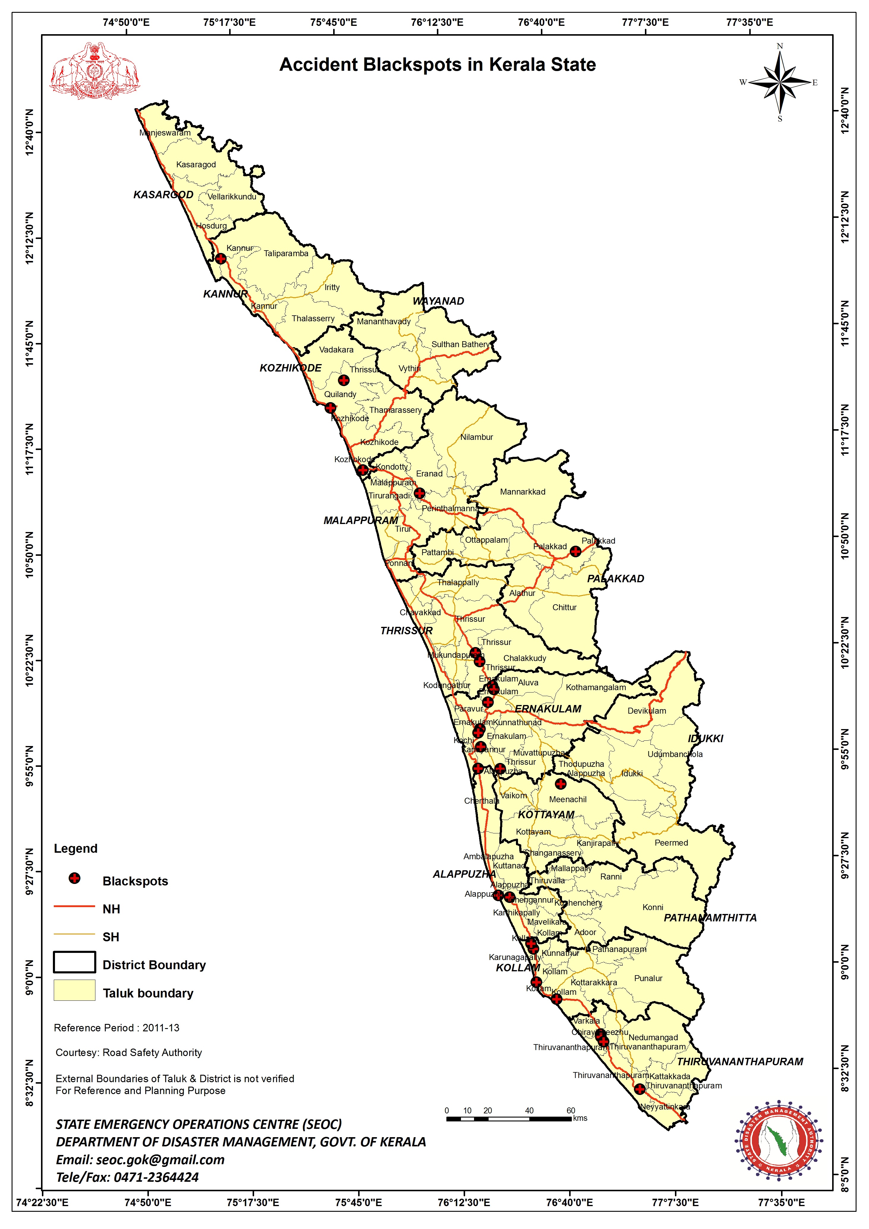
File:India Kerala location map.svg[edit]
Hello, thank you for making the map "File:India Kerala location map.svg". On May 4, 2012, you updated the map, moving Kuttampuzha and Edamalakkudy panchayaths from Idukki district to Ernakulam district. While Kuttampuzha was moved to Ernakulam in 2006, I cannot find any source that Edamalakkudy was moved as well. In fact, see this recent map published by the Government of Kerala, which places it in Idukki. Also, the physical village (which usually corresponds with the panchayath of the same name) is in Idukki. Can you please recheck your map? Sorry to disturb you. --Jose Mathew C (talk) 06:18, 26 April 2020 (UTC)
- Hello! I'm not disturb at all, especially as you give a link to an external source so I do not have to search for one :o). The situation seems to be a bit complicated. There are official maps at censusindia.gov.in or sdma.kerala.gov.in and Idukki District has got a map showing it like the location map ([4]). I think we will have to look a bit more intensive for the correct boundaries as there is lots of contradictory information. NNW 10:31, 26 April 2020 (UTC)
- 2015 Local body election results - The line of text just above the table says 'Idukki- Edamalakkudy Grama Panchayath' in Malayalam. --Jose Mathew C (talk) 14:06, 26 April 2020 (UTC)
- I know, there are several hints that Edamalakkudy belongs to Idukki but there are lots of maps that put it to Ernakulam, too. I cannot decide what is correct. We need a source that tells us why there are different answers to the same question and what is correct. NNW 14:47, 26 April 2020 (UTC)
Straßenkarte Bachstraße[edit]
Lieber NNW, Du hattest mir vor fast sieben Jahren diese schöne Karte für die Bramfelder Straße erstellt. Nun möchte ich (Stück für Stück) einen Artikel über die Bachstraße erstellen. Magst Du mir dafür eine entsprechende Karte machen? Ich würde mich sehr freuen! Viele Grüße vom Mogelzahn (talk) 13:36, 27 April 2020 (UTC)
- Moin! So wie bei der Bramfelder, also eng an der Straße entlang, oder etwas weiter gefasst? NNW 15:51, 27 April 2020 (UTC)
- Da ich mich beim Artikel nur auf die Bachstraße beziehe, kann das gerne auch eng gefasst werden. Sollte aber jemand mal einen Artikel über das Komponistenviertel schreiben wollen (Zaunpfahl schenk), dann wäre eine umfassende Karte natürlich auch nicht schlecht. Insofern lasse ich Dir da freie Hand. --Mogelzahn (talk) 19:00, 27 April 2020 (UTC)
- Wenn das ordentlich aufgezogen wird, kann man so eine Karte immer noch erweitern. NNW 19:04, 27 April 2020 (UTC)
- Dann machen wir die "schmale" Karte. --Mogelzahn (talk) 19:18, 27 April 2020 (UTC)
- Bitte sehr: Karte Bachstraße.png. NNW 11:10, 28 April 2020 (UTC)
- Vielen Dank! --Mogelzahn (talk) 18:44, 28 April 2020 (UTC)
- Bitte sehr: Karte Bachstraße.png. NNW 11:10, 28 April 2020 (UTC)
- Dann machen wir die "schmale" Karte. --Mogelzahn (talk) 19:18, 27 April 2020 (UTC)
- Wenn das ordentlich aufgezogen wird, kann man so eine Karte immer noch erweitern. NNW 19:04, 27 April 2020 (UTC)
- Da ich mich beim Artikel nur auf die Bachstraße beziehe, kann das gerne auch eng gefasst werden. Sollte aber jemand mal einen Artikel über das Komponistenviertel schreiben wollen (Zaunpfahl schenk), dann wäre eine umfassende Karte natürlich auch nicht schlecht. Insofern lasse ich Dir da freie Hand. --Mogelzahn (talk) 19:00, 27 April 2020 (UTC)
<ausrück>Den Artikel gibts inzwischen auch. --Mogelzahn (talk) 13:33, 29 April 2020 (UTC)
How to align maps[edit]
I am trying to add a coastline and rivers to a map already on Wikipedia, and I am using state boundaries as a guide to align it. However, the boundaries are not aligning and so the rivers are all out of place. There is one specific area that, when I align everything else, does not align with the correct boundary. Can you give me tips on how to do this? I am using GSHHG data for rivers and have found a separate dataset for state boundaries. C1MM (talk) 18:32, 1 May 2020 (UTC)
- Perhaps map and data have got different projections. Perhaps there is a mistake in the map or in the data. NNW 08:20, 2 May 2020 (UTC)
File:S-Bahn Rhein-Ruhr 2020.svg[edit]
Tach, danke nochmal für die erneute Aktualisierung der Karte: allerdings muss beim „Städteblobb“ Gelsenkirchen noch der Bahnhof Gelsenkirchen-Buer Nord auf der S9 noch mit drin sein. LG --Metrophil (talk) 15:23, 15 May 2020 (UTC)
- Moin! Und GE-Hassel auch noch. Ist korrigiert. NNW 15:40, 15 May 2020 (UTC)
Info zu einer deiner Karten :-)[edit]
Hallo NNW, vielleicht interessiert dich das ja: File talk:Karte Freilichtmuseum Groß Raden.png. Grüße, Grand-Duc (talk) 14:08, 28 May 2020 (UTC)
- Moin! Danke für den Hinweis! Korrekte Angaben, obwohl es nur ganz schwach im Layout-Hintergrund liegt und kaum zu sehen ist. Sehr schön! Viele Grüße, NNW 15:32, 28 May 2020 (UTC)
Request For Update Map[edit]
Hy Can You Please Update This Map File:Pakistan location map2.svg in 2019 Federally Administered Tribal Areas (FATA) Region Was Merge in To Khyber Pakhtunkhwa. — Preceding unsigned comment was added by 103.141.158.114 (talk) 06:20, 1 June 2020 (UTC)
- It's updated now. NNW 08:44, 1 June 2020 (UTC)
- Thanks — Preceding unsigned comment was added by 103.141.158.114 (talk) 06:12, 3 June 2020 (UTC)
Request to update map[edit]
Hi NordNordWest, I am sorry that I needed to request you again to update the map of Nepal (File:Nepal adm location map.svg and Sudurpashchim Pradesh (File:Nepal Sudurpashchim Pradesh adm location map.svg) maps because there is matter going over the Kalapani. Nepal has officially included this area in her map which was left because of dispute. This area was never Included in the Maps of Nepal as we know the disputed territory is old than the establishment of survey department in Nepal in 1975. Kalapani is included in map of Nepal in British map though I would like to request you to update the map. As the Kalapani is being administered by India you can show this area as disputed on Map of Nepal.
-
Sudurpashchim including Kalapani
-
 British map of Kalapani

.png)
.svg)
![[1]](https://www.cia.gov/library/publications/resources/the-world-factbook/attachments/maps/TI-map.gif)
![[2]](https://commons.wikimedia.org/wiki/File:China–Tajikistan_border.gif)
.svg)
.svg)
_2.svg)
.svg)
Thank you---Raju Babu (talk) 06:10, 2 June 2020 (UTC)
- Yeah, I already know. I will update the maps as soon as possible. NNW 07:47, 2 June 2020 (UTC)
Straßenkarte Herderstraße[edit]
Ich mal wieder mit einem meiner Wünsche ;-) Inzwischen bin ich bei meiner Stadtteiltätigkeit in der Herderstraße angekommen und wollte höflich anfragen, ob ich dafür auch eine Karte bekommen könnte. --Mogelzahn (talk) 13:54, 3 June 2020 (UTC)
- Viel darzustellen gibt es da aber nicht. NNW 14:39, 3 June 2020 (UTC)
- DA hast Du natürlich recht. Aber ich habe auch irgendwie keine Bilder von der Straße. --Mogelzahn (talk) 15:10, 3 June 2020 (UTC)
- Wahrscheinlich gibt es nur Herderstraße (Hamburg-Barmbek-Süd und -Winterhude).jpg. Ist nicht die fotogenste Straße. NNW 15:14, 3 June 2020 (UTC)
- Und das ist dann auch noch falsch benamst :-( Aber das Bild ist gut, weil es die Altbebauung im Osten und die Neubebauung im Westen darstellt. --Mogelzahn (talk) 16:52, 3 June 2020 (UTC)
- Dateinamen kann man ändern. Und falls Fotos fehlen, ist die Herderstraße ja auch durchaus erreichbar. :o) NNW 16:54, 3 June 2020 (UTC)
- Ich kann das als Nichtadmin wohl nicht,oder? Und am knipsen für Wikipedia ist mir ziemlich der Spaß vergangen, nachdem ich zu oft für angeblich mangelhafte Leistungen angemault worden bin. --Mogelzahn (talk) 16:56, 3 June 2020 (UTC)
- Du musst Filemover sein (bin ich). Zur Info an @Bernhard Diener. Gemaule bei Bildern ignoriere ich. Wenn du was benötigst, sag Bescheid. NNW 16:58, 3 June 2020 (UTC)
- Vielen Dank für die Verschiebung. --Mogelzahn (talk) 18:35, 3 June 2020 (UTC)
- @Mogelzahn: Karte Herderstraße.png. NNW 18:46, 15 June 2020 (UTC)
- Danke schön! --Mogelzahn (talk) 19:55, 19 June 2020 (UTC)
- @Mogelzahn: Karte Herderstraße.png. NNW 18:46, 15 June 2020 (UTC)
- Vielen Dank für die Verschiebung. --Mogelzahn (talk) 18:35, 3 June 2020 (UTC)
- Du musst Filemover sein (bin ich). Zur Info an @Bernhard Diener. Gemaule bei Bildern ignoriere ich. Wenn du was benötigst, sag Bescheid. NNW 16:58, 3 June 2020 (UTC)
- Ich kann das als Nichtadmin wohl nicht,oder? Und am knipsen für Wikipedia ist mir ziemlich der Spaß vergangen, nachdem ich zu oft für angeblich mangelhafte Leistungen angemault worden bin. --Mogelzahn (talk) 16:56, 3 June 2020 (UTC)
- Dateinamen kann man ändern. Und falls Fotos fehlen, ist die Herderstraße ja auch durchaus erreichbar. :o) NNW 16:54, 3 June 2020 (UTC)
- Und das ist dann auch noch falsch benamst :-( Aber das Bild ist gut, weil es die Altbebauung im Osten und die Neubebauung im Westen darstellt. --Mogelzahn (talk) 16:52, 3 June 2020 (UTC)
- Wahrscheinlich gibt es nur Herderstraße (Hamburg-Barmbek-Süd und -Winterhude).jpg. Ist nicht die fotogenste Straße. NNW 15:14, 3 June 2020 (UTC)
- DA hast Du natürlich recht. Aber ich habe auch irgendwie keine Bilder von der Straße. --Mogelzahn (talk) 15:10, 3 June 2020 (UTC)
.jpg)
Map request[edit]
Hi, I noticed you were the one who created the File:Scotland_South.png location map. It is being used on the w:East of Scotland Football League and w:West of Scotland Football League pages, however as you can see from the club markers the area shown is much larger than the area covered by the leagues.
I'm wondering if it would be possible for you to create two additional cropped location maps of Scotland, which would focus much closer on these Scotland South "east" and "west" areas? As currently there's nothing in between the Scotland South map and the maps of council areaa. Thanks Boothy m (talk) 19:34, 7 June 2020 (UTC)
- Hello! As long as these new maps can only used in one article I won't create these files. Are there any reasonable other purposes for them? NNW 13:57, 8 June 2020 (UTC)
- Thanks for the reply. They would be used on more than one article - at the very least they would also be used in the articles for each season of these football leagues.
- If you look at w:2019–20 East of Scotland Football League you can see how a number of smaller maps need to be used because the File:Scotland_South.png location map covers too large an area to fit all the clubs in.
- The Scotland_South map is used in a similar way - for example, instead of using the entire map of Scotland on the w:2017–18_Scottish_League_One#Stadia_and_locations page, the Scotland_South map is used as the clubs are all located in that area. I'm thinking if the Scotland_South map exists, I don't see why South East and West versions can't also exist? Boothy m (talk) 14:50, 13 June 2020 (UTC)
- @Boothy m: Scotland Southeast location map.svg and Scotland Southwest location map.svg are available now. NNW 17:21, 30 June 2020 (UTC)
- Vielen Dank! Boothy m (talk) 11:04, 1 July 2020 (UTC)
Aberdeen map[edit]
Sorry, couldn't help notice you updated the Edinburgh location map to include the new Queensferry crossing - would it be possible for you to do the same for the Aberdeen map to include the new A90 road (w:AWPR)? https://www.openstreetmap.org/?mlat=57.13782&mlon=-2.24697&zoom=12#map=12/57.1447/-2.1973
- It's updated, too. NNW 17:21, 1 July 2020 (UTC)
De facto boundaries[edit]
Hello, since you're an author of this template, I'd like to ask for your opinion on this edit. I believe it changes the meaning of the template in whole. I have tried to discuss the issue at Admins' board, but got no reaction... --GeXeS (talk) 06:46, 8 June 2020 (UTC)
- Hello! When I saw the edits my first thought was "bad idea". It is correct to say that this template is unclear to whom it applies (the uploader? Commons? Wikimedia Foundation?) and the template still highlights that a map shows the de facto situation. So I didn't react to the change. But I still think that it is the better way to announce a change before any edit so it is possible to discuss everything, especially when it is a template which was created to end repetitive and annoying discussions (and even more important if you are right and the user is quite active in disputed area topics). It would have avoided lots of discussions in this case. To take a note to that a ping to @Cherkash. NNW 13:53, 8 June 2020 (UTC)

|
File:China Xinjiang location map.svg has been listed at Commons:Deletion requests so that the community can discuss whether it should be kept or not. We would appreciate it if you could go to voice your opinion about this at its entry.
If you created this file, please note that the fact that it has been proposed for deletion does not necessarily mean that we do not value your kind contribution. It simply means that one person believes that there is some specific problem with it, such as a copyright issue. Please see Commons:But it's my own work! for a guide on how to address these issues. |
Geographyinitiative (talk) 01:21, 9 June 2020 (UTC)
English translation for File:Karte Slowakischer Nationalaufstand 1944 - Aufstandsbeginn.png[edit]
This excellent map is being used on 3 enwiki pages and has high relevance and significance to many others which could be created about topics related to Slovakia's wwii history. Could I persuade you to make an English version? (I would be more than willing to help with translating the German text). Many thanks. Buidhe (talk) 00:00, 10 June 2020 (UTC)
- It's easy to persuade me. :o) We just need to find a proper translation. NNW 07:28, 10 June 2020 (UTC)
- Großdeutsches Reich = Greater German Reich
- Slowakei = Slovakia
- Ungarn = Hungary
- Deutsche Schutzzone = German Zone of Protection
- Ostslowakische Armee = Eastern Slovak Army (?)
- Donau = Danube
- March = Morava
- Váh (Waag) = Váh
- Turiec (Turz) = Turiec
- Tatra = Tatra
- Niedere Tatra = Low Tatra
- Kampfgruppe = "battle group", but may be better not to translate
- Angriffsbataillon der 1. Panzerarmee = Assault battalion of the 1st Panzer Army
- seit März 1944 von der Wehrmacht besetzt = occupied by the Wehrmacht from March 1944
- Staatsgrenzen 1944 = 1944 borders
- heutige slowakische Südgrenze = postwar border (I think it is obvious that this is the border between (Czecho)slovakia and Hungary)
- Sitz der slowakischen Kollaborationsregierung = seat of the Tiso government
- Sitz der slowakischen Aufstandsregierung = seat of the insurgent goverment
- von den Aufständischen kontrolliertes Gebiet = area controlled by the insurgency
- von deutschen Truppen besetzte Slowakei = area controlled by German troops
- Garnisonen, die sich dem Aufstand anschlossen = Slovak Army units that joined the uprising
- Garnisonen, die sich dem Aufstand teilweise anschlossen = Slovak Army units that partially joined the uprising
- Garnisonen, die sich dem Aufstand nicht anschlossen = Slovak Army units that did not join the uprising
- andere Orte = other places
- I think that's everything that needs translating. Thanks in advance! Buidhe (talk) 09:21, 10 June 2020 (UTC)
- Here it is: Map Slovak National Uprising in 1944 - first days.png. A lot of postwar borders are missing but let's see if someone complains. NNW 09:56, 10 June 2020 (UTC)
Bitte[edit]
Hallo NNW. Könntest Du mir diese File:Wahlkreise in Namibia (2014).svg Karte anpassen, so dass sich nur die Regionen farblich unterscheiden und keine Wahlkreise sichtbar sind. Ich bekomme es nicht hin (probiere mich gerade erst an SVGs, da die Konturen der Wahlkreisgrenzen immer sichtbar bleiben :-() Vielen Dank --Chtrede (talk) 05:42, 11 June 2020 (UTC)
.svg)
- Moin! Du meinst, wie Namibia, administrative divisions - de - colored.svg, nur ohne Schrift? Viele Grüße, NNW 08:35, 11 June 2020 (UTC)
- Genau. Nur eben im neuen Stil. Gerne auch ohne die Regionalnamen, d. h. nur farbliche Unterscheidungen. Danke --Chtrede (talk) 10:19, 11 June 2020 (UTC)
- Bitte sehr: Regionen in Namibia.svg. NNW 17:11, 11 June 2020 (UTC)
- Genau. Nur eben im neuen Stil. Gerne auch ohne die Regionalnamen, d. h. nur farbliche Unterscheidungen. Danke --Chtrede (talk) 10:19, 11 June 2020 (UTC)
Vielen vielen Dank --Chtrede (talk) 06:37, 12 June 2020 (UTC)
Hello! I would like to use this updated file you created in the Hebrew Wikipedia. I noticed you didn't mention the East and West borders of the map, as you did in the older map. Should they be left the same? Because when I tried to switch the file in our template it didn't seem to work well, and our local map experts are not very active these days. Mbkv717 (talk) 10:47, 17 June 2020 (UTC)


- Hello! The projection of Norway location map.svg a distorted equirectangular projection, the projection of Norway adm location map.svg is a conic projection. With a conic projection you cannot give East and West borders (and no North and South borders, either) because it changes everywhere. I don’t know how he:תבנית:מפת מיקום/רוסיה (conic, too) is working but you have to copy the system. In de:wp we have a special workaround for conic projections so it is quite easy: de:Vorlage:Positionskarte/Längentreue Kegelprojektion. Maybe you have a look how en:wp or fr:wp managed it. Russia and Canada are the typical countries with this projection and I started with even more countries because they look much better that way than with an equirectangular projection. I know that it makes it a bit more difficult for the Wikipedia projects. NNW 14:50, 17 June 2020 (UTC)
- Well that seems way beyond my knowledge, but I'll give it a try. Apparently in cases like Russia and Canada there are sub-templates for the relevant calculations - for example compare the source code here and here. But in de:Vorlage:Positionskarte Norwegen there seem to be something different. Are you saying that de:Vorlage:Positionskarte/Längentreue Kegelprojektion is a kind of universal sub-template? Mbkv717 (talk) 18:04, 17 June 2020 (UTC)
- I am not very into these templates and unfortunately the creator of this template is more or less inactive. I can only guess how exactly all these templates work together, sorry. NNW 10:49, 18 June 2020 (UTC)
- OK, someone successfully created a sub-template, it now seem to be working, but there is a small problem. I the file you defined that the maximal latitude at the bottom is 58, but en:Pysen, the southernmost place in Norway, has a latitude of 57.9585. in File:Norway Agder adm location map.svg you defined that the maximal latitude at the bottom is 57.9, shouldn't it be the same for the whole country? Mbkv717 (talk) 13:33, 18 June 2020 (UTC)
- I am not very into these templates and unfortunately the creator of this template is more or less inactive. I can only guess how exactly all these templates work together, sorry. NNW 10:49, 18 June 2020 (UTC)
- Well that seems way beyond my knowledge, but I'll give it a try. Apparently in cases like Russia and Canada there are sub-templates for the relevant calculations - for example compare the source code here and here. But in de:Vorlage:Positionskarte Norwegen there seem to be something different. Are you saying that de:Vorlage:Positionskarte/Längentreue Kegelprojektion is a kind of universal sub-template? Mbkv717 (talk) 18:04, 17 June 2020 (UTC)
- 58° is the latitude at the central meridian of 16° E. As all longitudes are segments of a circle the southernmost point in the region of Agder is about 57,7°. So there is no problem to show Pysen, see de:Benutzer:NordNordWest/test#Pysen. NNW 14:17, 18 June 2020 (UTC)
- Oh, I see now we misunderstood it. Anyway, thank you very much! Mbkv717 (talk) 17:15, 18 June 2020 (UTC)
- 58° is the latitude at the central meridian of 16° E. As all longitudes are segments of a circle the southernmost point in the region of Agder is about 57,7°. So there is no problem to show Pysen, see de:Benutzer:NordNordWest/test#Pysen. NNW 14:17, 18 June 2020 (UTC)
Straßenkarte Winterhuder Weg[edit]
Ich mal wieder mit einem meiner Wünsche ;-) Inzwischen bin ich bei meiner Stadtteiltätigkeit im Winterhuder Weg angekommen und wollte höflich anfragen, ob ich dafür auch eine Karte bekommen könnte. Da gibts auch ein bißchen mehr zu zeichnen, als bei der Herderstraße ;-) --Mogelzahn (talk) 17:33, 1 July 2020 (UTC)
- Na dann: Karte Winterhuder Weg.png. NNW 18:01, 2 July 2020 (UTC)
- TOP! Vielen Dank! --Mogelzahn (talk) 19:10, 2 July 2020 (UTC)
Kennzeichen-App[edit]
Hallo NordNordWest,
zunächst einmal vielen vielen Dank für die vielen tollen Karten bei Wikipedia. Da hast Du bestimmt viel Arbeit damit.
Ich bin ein großer Fan von Kennzeichen. Da bin ich schon früher mit meiner Schwester am Straßenrand gesessen und wir haben die Kennzeichen aufgeschrieben und im Lexikon nachgeschaut, woher die Autos kamen (das war noch die Zeit vor dem Internet und das läßt bestimmt auch auf mein Alter schließen ;-) ). Als vor 10 Jahren Microsoft dann Windows Phone rausbrachte war ich ein riesiger Fan von dem neuen flachen Design und habe dann auch Apps dafür entwickelt.
Der Kennzeichensammler war meine erste App und alle meine Kollegen haben gemeint, das braucht kein Mensch. Mit der App konnte man Kennzeichen eingeben und als "Gesehen" markieren. Ziel ist es dann z.B alle Kennzeichen in Deutschland zu sammeln. Die App war unheimlich erfolgreich und wurde dann auch 250.000 mal heruntergeladen (dann sind die Kinder bei der Autofahrt in den Urlaub beschäftigt :-) ). Microsoft hat Windows Phone ja schon lange aufgegeben und trotzdem war ich meinem Smartphone noch treu. Jetzt musste ich dann doch auf Android wechseln und habe meine App vom ersten Tag an vermisst. Daher schreibe ich gerade eine App für Android. Bei Windows Phone war das Design unheimlich minimalistisch und daher habe ich die Karten eher "künstlerisch" als "genau" selbst in der Bildbearbeitung gepinselt. Das passt aber für Android gar nicht. Dein Kartendesign würde unheimlich gut passen. Du veröffentlichst Deine Karten ja in der CC BY-SA 3.0 Lizenz. Das müsste für meine App passen. Da Du ja aber echt viel Arbeit investierst möchte ich Deine Karten nicht ohne Dein OK für meine App nutzen.
Meine App wäre komplett kostenlos, ohne Werbung, ohne Add-Ins, usw. Das war schon bei Windows Phone so und wäre auch bei Android so. Ich weiß aber noch nicht ob ich sie überhaupt veröffentliche. Das hängt ein bißchen davon ab, ob die Play Store-Bedingungen auch für kostenlose Apps wirklich akzeptabel sind. Da drücke ich mich noch davor, das durchzulesen.
Ich habe mal zwei Screenshots aus dem Emulator erstellt:
http://www.escbase.de/karte.jpg
Das wäre Deine Karte für Deutschland in meiner App. Ich habe das PNG in der Größe runtergerechnet und mit JPEG komprimiert in meine App gepackt (dann komme ich unter 100kb pro Karte). Die Kreis sind dann die Kennzeichen. Dafür erzeuge ich dynamisch ein eigenes Bild mit transparentem Hintergrund und zeige beide Bilder übereinanderliegend an. Gesehene Kennzeichen werden ausgefüllt dargestellt. Natürlich wird die Karte auch für einzelne Kennzeichen verwendet, dann blickt ein einzelner Kreis an der Stelle der Herkunft des Kennzeichens.
Oben rechts gibt es ein Info-Icon. Da kommt dann in einem Dialogfenster Deine Namensnennung und die Hinweise zur Lizenz. Da habe ich Eure coole "Du musst den Urheber angeben - Zeig mir wie"-Funktion verwendet:
http://www.escbase.de/urheber.jpg
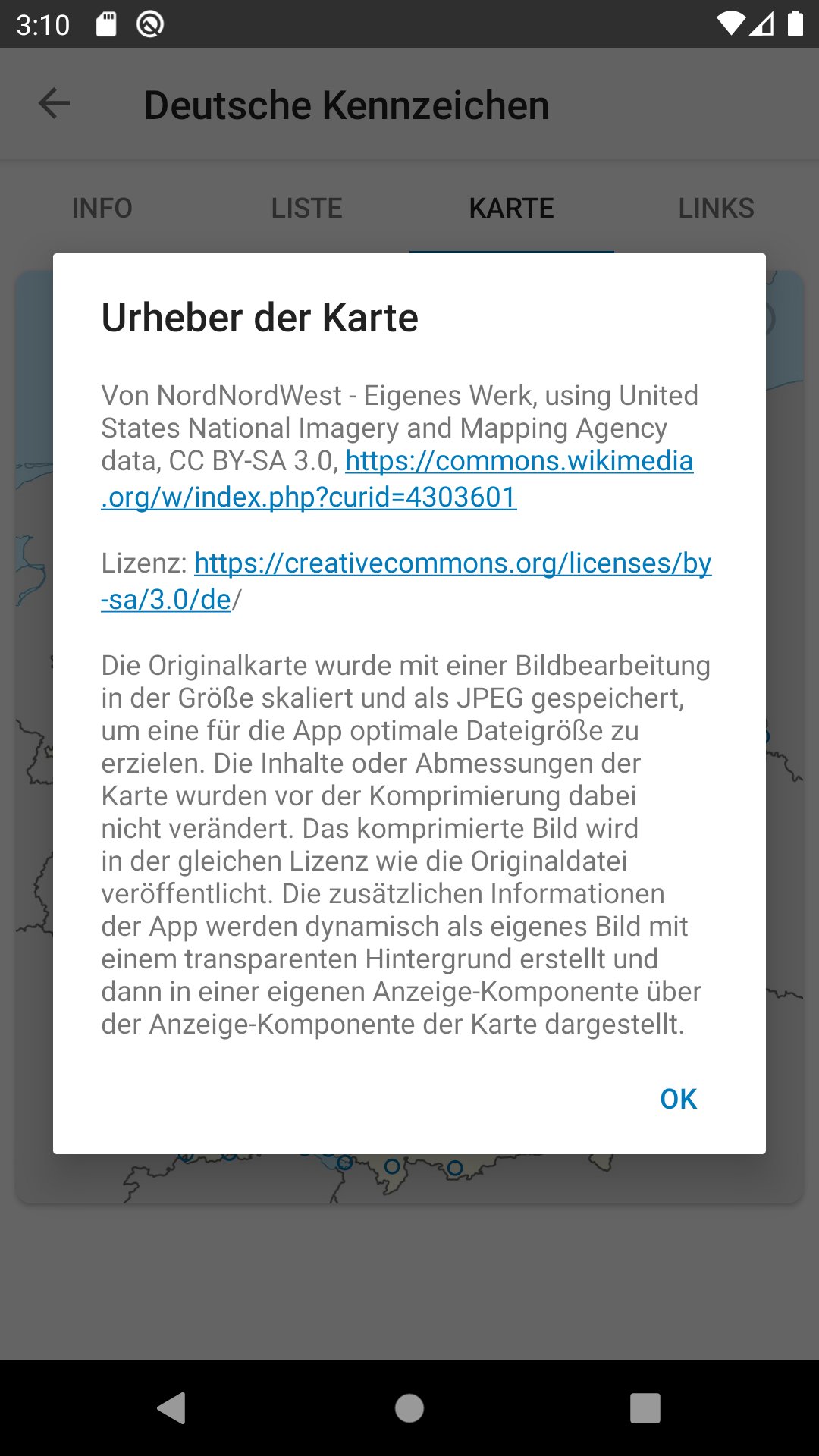
Vielleicht kannst Du Dir vorstellen, wie die Jagd nach den Kennzeichen so läuft. In Deutschland habe ich schon alle bis auf eine paar wenige in Mecklenburg-Vorpommern. Meine geplante Urlaubsreise in den Norden ist dieses Jahr aber leider wegen Corona ins Wasser gefallen.
Wäre es OK für Dich, wenn ich Deine Karten in dieser Form nutze? Bei der Norwegen-Karte habe ich die etwas ältere quadratische Plattkarte genommen. Da stimmen dann zwar Regionen nicht mehr ganz, aber als Kennzeichen-Fan freut man sich so, eine neues Kennzeichen zu sehen das einem das gar nicht auffällt, das da noch ein paar Regionalgrenzen mehr drin sind ;-) Bei der Umrechnung der Kegelprojektion auf mein transparentes Bild musste ich die Segel streichen. Das habe ich einfach nicht hinbekommen. Die Formeln im Internet haben sich für mich wie böhmische Dörfer angehört und bei allen meinen Versuchen sind die Kreise im Nirwana gelandet. Da liegt die Mathematik einfach schon zu lange zurück. Und bei den Plattkarten ist das super einfach. Das bekomme sogar ich hin :-)
Tschüss Rolf — Preceding unsigned comment was added by 84.144.99.29 (talk) 16:15, 2 July 2020 (UTC)
- Hallo Rolf! Natürlich darfst du die Karten verwenden und das auch ohne zu fragen und auch um Geld mit der App zu verdienen, wenn du das möchtest. Die nötigen Angaben hast du alle gemacht. Den Teil „Eigenes Werk, using United States National Imagery and Mapping Agency data“ kannst du auch weglassen, dann spart das etwas Text. Das „CC BY-SA 3.0“ würde ich hinter „Lizenz: “ setzen und dann den Link zur Lizenz. Du kannst aber natürlich auch alles so lassen, wie es jetzt ist. Viele Grüße, NNW 16:52, 2 July 2020 (UTC)
- Super, vielen Dank für Deine nette Antwort. Deine Vorschläge nehme ich alle auf, das wird ja dann auch viel übersichtlicher. Viele Grüße aus dem Süd-Süd-Westen nach NordNordWest :-) Tschüss Rolf — Preceding unsigned comment was added by 93.219.47.131 (talk) 07:02, 3 July 2020 (UTC)
[[:The Matsu line needs to be extended around Dongyin, Lienchiang]] requires updating[edit]
Hi NordNordWest,
Thank you for your contributions to Commons. I noticed [[:The Matsu line needs to be extended around Dongyin, Lienchiang]] is out of date. Could you update it? Thanks again. Geographyinitiative (talk) 03:27, 14 July 2020 (UTC)
- I noticed that you have a problem to handle templates. NNW 09:11, 14 July 2020 (UTC)
India states and territories maps[edit]
Hallo. Ich kann sehen, dass du sehr gut in maps machen bist. Bitte, kannst du India maps aktualizieren? Kuk mal an: Commons:Graphic Lab/Map workshop, Part India maps. Vielen Dank. --Unpocoloco (talk) 05:39, 17 July 2020 (UTC)
- Hallo! India relief location map.jpg ist aktualisiert. NNW 15:54, 17 July 2020 (UTC)
- Vielen Dank. Kannst du bitte auch File:India-locator-map-blank.svg aktualisieren. Ist sehr oft benutzt. Danke. --Unpocoloco (talk) 20:06, 18 July 2020 (UTC)
- Ist auch aktualisiert. NNW 17:49, 25 July 2020 (UTC)
- Vielen Dank. Kannst du bitte auch File:India-locator-map-blank.svg aktualisieren. Ist sehr oft benutzt. Danke. --Unpocoloco (talk) 20:06, 18 July 2020 (UTC)
File tagging File:Corcovado Blu.jpg[edit]
This media was probably deleted.
|
Thanks for uploading File:Corcovado Blu.jpg. This media is missing permission information. A source is given, but there is no proof that the author or copyright holder agreed to license the file under the given license. Please provide a link to an appropriate webpage with license information, or ask the author or copyright holder to send an email with copy of a written permission to VRT (permissions-commons@wikimedia.org). You may still be required to go through this procedure even if you are the author yourself; please see Commons:But it's my own work! for more details. After you emailed permission, you may replace the {{No permission since}} tag with {{subst:PP}} on file description page. Alternatively, you may click on "Challenge speedy deletion" below the tag if you wish to provide an argument why evidence of permission is not necessary in this case.
Please see this page for more information on how to confirm permission, or if you would like to understand why we ask for permission when uploading work that is not your own, or work which has been previously published (regardless of whether it is your own). The file probably has been deleted. If you sent a permission, try to send it again after 14 days. Do not re-upload. When the VRT-member processes your mail, the file can be undeleted. Additionally you can request undeletion here, providing a link to the File-page on Commons where it was uploaded ([[:File:Corcovado Blu.jpg]]) and the above demanded information in your request. |
Ruthven (msg) 09:19, 27 July 2020 (UTC)
File tagging File:Hombre Banano.jpg[edit]
This media was probably deleted.
|
Thanks for uploading File:Hombre Banano.jpg. This media is missing permission information. A source is given, but there is no proof that the author or copyright holder agreed to license the file under the given license. Please provide a link to an appropriate webpage with license information, or ask the author or copyright holder to send an email with copy of a written permission to VRT (permissions-commons@wikimedia.org). You may still be required to go through this procedure even if you are the author yourself; please see Commons:But it's my own work! for more details. After you emailed permission, you may replace the {{No permission since}} tag with {{subst:PP}} on file description page. Alternatively, you may click on "Challenge speedy deletion" below the tag if you wish to provide an argument why evidence of permission is not necessary in this case.
Please see this page for more information on how to confirm permission, or if you would like to understand why we ask for permission when uploading work that is not your own, or work which has been previously published (regardless of whether it is your own). The file probably has been deleted. If you sent a permission, try to send it again after 14 days. Do not re-upload. When the VRT-member processes your mail, the file can be undeleted. Additionally you can request undeletion here, providing a link to the File-page on Commons where it was uploaded ([[:File:Hombre Banano.jpg]]) and the above demanded information in your request. |
Ruthven (msg) 09:23, 27 July 2020 (UTC)
File tagging File:Milano - piazza Monte Titano - graffito di Blu.jpg[edit]
This media was probably deleted.
|
Thanks for uploading File:Milano - piazza Monte Titano - graffito di Blu.jpg. This media is missing permission information. A source is given, but there is no proof that the author or copyright holder agreed to license the file under the given license. Please provide a link to an appropriate webpage with license information, or ask the author or copyright holder to send an email with copy of a written permission to VRT (permissions-commons@wikimedia.org). You may still be required to go through this procedure even if you are the author yourself; please see Commons:But it's my own work! for more details. After you emailed permission, you may replace the {{No permission since}} tag with {{subst:PP}} on file description page. Alternatively, you may click on "Challenge speedy deletion" below the tag if you wish to provide an argument why evidence of permission is not necessary in this case.
Please see this page for more information on how to confirm permission, or if you would like to understand why we ask for permission when uploading work that is not your own, or work which has been previously published (regardless of whether it is your own). The file probably has been deleted. If you sent a permission, try to send it again after 14 days. Do not re-upload. When the VRT-member processes your mail, the file can be undeleted. Additionally you can request undeletion here, providing a link to the File-page on Commons where it was uploaded ([[:File:Milano - piazza Monte Titano - graffito di Blu.jpg]]) and the above demanded information in your request. |
Ruthven (msg) 09:24, 27 July 2020 (UTC)
File tagging File:Blusaragossa.jpg[edit]
This media was probably deleted.
|
Thanks for uploading File:Blusaragossa.jpg. This media is missing permission information. A source is given, but there is no proof that the author or copyright holder agreed to license the file under the given license. Please provide a link to an appropriate webpage with license information, or ask the author or copyright holder to send an email with copy of a written permission to VRT (permissions-commons@wikimedia.org). You may still be required to go through this procedure even if you are the author yourself; please see Commons:But it's my own work! for more details. After you emailed permission, you may replace the {{No permission since}} tag with {{subst:PP}} on file description page. Alternatively, you may click on "Challenge speedy deletion" below the tag if you wish to provide an argument why evidence of permission is not necessary in this case.
Please see this page for more information on how to confirm permission, or if you would like to understand why we ask for permission when uploading work that is not your own, or work which has been previously published (regardless of whether it is your own). The file probably has been deleted. If you sent a permission, try to send it again after 14 days. Do not re-upload. When the VRT-member processes your mail, the file can be undeleted. Additionally you can request undeletion here, providing a link to the File-page on Commons where it was uploaded ([[:File:Blusaragossa.jpg]]) and the above demanded information in your request. |
Ruthven (msg) 09:25, 27 July 2020 (UTC)
.png)
Hi,
in w:de:Preisklasse#Klasse 1 sin drei coole Karten von dir eingebunden. Leider scheint es in Image:D-Bahnhöfe Kategorie 1 (bis 2010).png einen seltsamen Fehler zu geben; ein Teil der Karte im Dreiländereck BaWü, Bayern und Hessen sieht sehr seltsam aus; die Grenzen und Flüsse sind nicht miteinander vollständig verbunden und sehen auch anders aus als in den beiden anderen Karten. sугсго 07:04, 29 July 2020 (UTC)
.png)
- Moin! Diese Datei ist gar nicht von mir, sondern von Benutzer:Zeeuwsebad, dem wohl irgendein Retuschefehler passiert ist. Das müsste ich neu herstellen. NNW 08:30, 29 July 2020 (UTC)
- Und ich frage, mich ob die Karte überhaupt korrekt ist. Die 2009er Version der Kategorie-1-Bahnhöfe-Karte so so aus, also mit Frankfurt Flughafen, und der Artikel mit Stand 2009 führt diesen Bahnhof auch auf. NNW 10:10, 29 July 2020 (UTC)
|
|
File:Vestland våpen.png has been listed at Commons:Deletion requests so that the community can discuss whether it should be kept or not. We would appreciate it if you could go to voice your opinion about this at its entry.
If you created this file, please note that the fact that it has been proposed for deletion does not necessarily mean that we do not value your kind contribution. It simply means that one person believes that there is some specific problem with it, such as a copyright issue. Please see Commons:But it's my own work! for a guide on how to address these issues. |
Worldlydev (talk) 22:20, 30 August 2020 (UTC)
Karte ehemalige Regionen Namibias[edit]
Hallo NNW. Könntest Du mir analog zu File:Regionen in Namibia.svg eine Karte für die Regionen Namibias von 1990 bis 1992 erstellen. Ich habe als einzige Vorlage leider (bisher) nur diese hier auf S. 2 [5]. Es dürfen auch gerne die ehemaligen Distrikte (z. B. Grootfontein, Tsumeb usw) mit abgebildet werden (sicherlich dann nur in ihren Grenzen, aber nicht farblich nochmal auf der Ebene unterschieden). Danke & Gruß --Chtrede (talk) 09:21, 2 September 2020 (UTC)
- Moin! Zumindest schon mal eine bessere Vorlage: 1990 Namibia CIA.png. NNW 21:24, 3 September 2020 (UTC)
- Die aber nicht das benötigte so richtig abbildet. z. B. wurde Owambo geteilt und daraus zwei Regionen (Oshakati und Ondangwa). Aber Du wirst es schon hinbekommen. Danke Dir! :-) --Chtrede (talk) 12:59, 4 September 2020 (UTC)
Hallo NNW. Wollte nur nachfragen, ob Du dazu in naher Zukunft Zeit und vor allem auch Lust hast?! Viele Grüße & Danke --Chtrede (talk) 11:36, 19 October 2020 (UTC)
- Doch, doch, ist auf meiner Liste. NNW 12:14, 19 October 2020 (UTC)
- @Chtrede: Ich habe es mal vorgezogen, damit es von der Liste kann: Regionen in Namibia 1990–1992.svg. NNW 13:38, 19 October 2020 (UTC)
- Vielen Dank --Chtrede (talk) 13:47, 19 October 2020 (UTC)
Golubovci[edit]
Hi. Can you make a svg map of Golubovci urban municipality, which is part of Podgorica Capital City? Here is a map of Montenegrin municipalities where you can see a borders of Golubovci. Lackope (talk) 08:40, 23 September 2020 (UTC)
- Hello! Something like this or something like Tuzi in Montenegro (2018).svg but with Golubovci highlighted? NNW 08:55, 23 September 2020 (UTC)
- Hi, sorry for my late answer. :) I mean like Tuzi map. Lackope (talk) 19:45, 17 December 2020 (UTC)
.svg)
License for location maps[edit]
I really like your location maps of counties in Norway, such as the map of Viken, File:Norway_Viken_adm_location_map.svg . Along with my free contributions to Wikipedia I also submit images to The Great Norwegian Encyclopedia. Therefore I am wondering if I can use your blank county maps such as the one of Viken and remix them to highlight certain regions or municipalities within the county. But for them to be included in the encyclopedia they would have to be licensed under a free license. Would you be willing to give me permission to use the free license for all remixed works and have the images in the public domain? I can of course link to your map blanks and mention your username in the file descriptions. See: https://snl.no/Romerike for example of Wikimedia map included in an encyclopedia article. If not then I still thank you for your contributions to the Wiki :) Worldlydev ("int:Talkpagelinktext") 21:32, 24 September 2020 (UTC)
- I have a question: Why do the files have to have a free license when there is a "Store norske leksikon © 2020" at the bottom of that page? NNW 08:32, 25 September 2020 (UTC)
- Everything from the encyclopedia is free to use in any way unless stated otherwise. Images and texts not designated for free use but instead limited use (begrenset gjenbruk) are not to reused, republished, or rebuilt upon. They are still free to be quoted from in any way as stated here: https://meta.snl.no/begrenset_gjenbruk. And while it says here that all images with a CC-license can be used and that all images on Wikimedia are within grounds for use on SNL: https://meta.snl.no/Finn_leksikonbilder_til_fri_bruk. The clause about free use anywhere, even for articles and images designated limited use, does not allow for a license such as the "No Facebook License" you have chosen to use on your image. The reader of the article would be free to use what they find elsewhere, including on Facebook. So rebuilding upon an image like yours without permission to use a free license would be a no-go. Worldlydev (talk) 09:45, 25 September 2020 (UTC)
- It is not a "No Facebook License", it just indicates a re-user that there is an incompatibility between CC-BY-SA licenses and the ToU of Facebook. Not my invention, see also meta:Talk:Legal/CC BY-SA licenses and social media. And this incompatibility will be there if there is a "No Facebook" sign at my files or not. On the other hand I read in https://meta.snl.no/Finn_leksikonbilder_til_fri_bruk that everything at Commons with a CC-BY-SA license can be used. So I can see no problem for you to use these maps. NNW 10:43, 25 September 2020 (UTC)
- Sorry for the misunderstanding in that case about the the "No Facebook" sign. Is there an easy way to color in the various muncipalities? In other blanks I've been able to select the various muncipalities and apply a gradient. That doesn't seem to be the case here. Worldlydev (talk) 12:18, 25 September 2020 (UTC)
- These location maps weren't made for colouring the single municipalities. It's a single area for the whole fylke (to keep the file size smaller). NNW 12:21, 25 September 2020 (UTC)
B 109[edit]
Hallo! Da die Karte von 2016 ist die Frage, auf welcher Basis Du sie erstellt hast, Datei -File:Map D B109.svg. Geht um einen Editwar bei de:WP, wo Anfangs nur der Verlauf in Pankow das Problem war. Wenn ich aber Google sehe, verläuft die Strecke nicht wie Du eingetragen hast von Liebenberg, sondern von Berlin aus bis Wandlitz, dann folgt sie dem Verlauf der B 167, um dann von Liebenberg/Falkenthal nach Norden zu gehen. Könntest Du die Grafik bitte entsprechend ändern? Die L100 betrifft nur das Teilstück nördlich von Wandlitz, was so auch in der Landstraßenliste vermerkt wurde. Danke Oliver S.Y. (talk) 11:36, 25 September 2020 (UTC)
- Moin! Der gesamte Abschnitt in Brandenburg südlich der B167 wurde herabgestuft (siehe das amtliche https://bb-viewer.geobasis-bb.de/strassennetz/) und seit diesem Jahr nach der Instandsetzung auch der restliche Berliner Teil. Damit ist die B 109 nur noch nördlich von Falkenthal vorhanden. Google Maps ist für sowas nicht zu gebrauchen. Aktualisierung folgt natürlich. NNW 12:14, 25 September 2020 (UTC)
Fixing India map boundaries[edit]
On both new maps of India, Telangana's boundary is not changed to reflect changes made after Polavaram. Can you please update the location map, relief map and locator map to reflect this, similar to what was done here? Thanks. C1MM (talk) 00:03, 5 October 2020 (UTC)
- Which both new maps? NNW 08:41, 5 October 2020 (UTC)
- location map, locator map, and relief map. All three need to be updated with the correct AP/Telangana boundaries. You can see this districts map for an approximation of the correct boundaries. C1MM (talk) 20:02, 10 October 2020 (UTC)
- All done. NNW 16:55, 14 October 2020 (UTC)
- Also, what are the specific elevations typically used for the topographic map colors mentioned in the Conventions section Here? I know the colors and have a vague sense of the most accurate values but want to know what is actually used on things like the India relief map. C1MM (talk) 06:02, 23 October 2020 (UTC)
- As far as I know: maps have to look good, that's all. There is no specific height for colour X. Colours are used in a different way when a map with the Himalayas in it is made than when you create a map of the Netherlands. NNW 08:55, 23 October 2020 (UTC)
- Thanks. Can you also try and update some of the state maps? Telangana is done, but I think the Arunachal Pradesh location map has only approximate boundaries for the 25 districts (26 if including Itanagar). These are boundaries I have approximated when looking at maps. Do you have any concrete sources you can give me for fixing ths? Thanks. C1MM (talk) 05:53, 24 October 2020 (UTC)
- As far as I know: maps have to look good, that's all. There is no specific height for colour X. Colours are used in a different way when a map with the Himalayas in it is made than when you create a map of the Netherlands. NNW 08:55, 23 October 2020 (UTC)
- I haven't got any up to date sources for it, sorry. NNW 09:31, 24 October 2020 (UTC)
File:China Fujian2 location map.svg requires updating[edit]
Hi NordNordWest,
Thank you for your contributions to Commons. I noticed File:China Fujian2 location map.svg is out of date. Dongding Island is omitted. Could you update it? Thanks again. Geographyinitiative (talk) 00:09, 8 October 2020 (UTC)
The boundary line between Gilgit-Baltistan and Azad Kashmir[edit]
Hi, NordNordWest,
I think that the present THIN boundary line between Gilgit-Baltistan and Azad Kashmir, on both of the maps below, mistakenly suggests that those two dependent territories are parts of a single political entity, which is definitely not the case. It would be better to use a THICK boundary line between them, like the lines used for the boundaries of Pakistan, itself, to indicate that those two territories are administered separately from each other, which is the actual situation pertaining there.
https://commons.wikimedia.org/wiki/File:Pakistan_location_map.svg
https://commons.wikimedia.org/wiki/File:Pakistan_adm_location_map.svg
I also think that the boundary line between Gilgit-Baltistan and Azad Kashmir as shown on the two maps above should be updated to conform to the more recent boundary line that is shown on the map below. The eastern end of the Neelum District of Azad Kashmir was detached from Azad Kashmir in recent years and added to Gilgit-Baltistan. That detached area includes the villages of Kamri, Minimarg, and Domel and the lakes Crystal Lake and Rainbow Lake. Those five features are now included in the southernmost part of the Astore District of Gilgit-Baltistan.
https://commons.wikimedia.org/wiki/File:Pakistan_Gilgit_Baltistan_location_map.svg
Atelerixia (talk) 05:20, 9 October 2020 (UTC)
- I haven't forgotten our discussion, I just didn't have the time to update the map. So no need to repeat everything here. NNW 09:39, 11 October 2020 (UTC)
- I have corrected the boundary between these two areas but after thinking quite a while about it I disagree that it should be shown thick and hashed, too. NNW 16:02, 5 November 2020 (UTC)
File:Berlin in Germany and EU.png aktualisieren[edit]
Tach, NNW. Du hast kürzlich EU location Berlin.svg aktualisiert in Bezug auf die EU-Zugehörigkeit Großbritanniens (und …). Kannst Du so nett sein, das ebenso für das Derivat Berlin in Germany and EU.png zu tun? Und findest Du die andere benutzte Datei? Angeblich wurde sie nach Commons verschoben, aber unter dem Namen ist sie nicht existent. — Speravir – 23:33, 20 October 2020 (UTC)
- Moin! Die eine ist aktualisiert, die andere weiß ich auch nicht. NNW 09:03, 21 October 2020 (UTC)
- Danke
und dann muss ich mal bei den Admins nachfragen(du wolltest ja nicht mehr ). — Speravir – 17:53, 22 October 2020 (UTC)
 - Nee, gefunden: Das ist dann wohl jetzt diese Datei: Deutschland Lage Berlins.svg. Aber noch was Neues: Du bist doch eher Experte als ich, sind das hier nicht Duplikate? Nämlich Deutschland Laender.svg und Karte Bundesrepublik Deutschland.svg, Weil letztere nicht in die Kat. Locator maps of states of Germany (green scheme) einsortiert ist, hat sie jemand nicht gefunden und noch einmal produziert. — Speravir – 18:09, 22 October 2020 (UTC)
- Das sind eindeutig Duplikate. NNW 18:23, 22 October 2020 (UTC)
- Danke
Hallo, ...[edit]
zur Info: [6]. Gruß -- Bwag (talk) 13:02, 9 November 2020 (UTC)
![[6]](https://commons.wikimedia.org/w/index.php?title=File_talk%3AKarte_Terroranschlag_in_Wien_2020.png&type=revision&diff=511505859&oldid=511020372)
File:Azerbaijan adm location map.svg requires updating[edit]
Hi NordNordWest,
Thank you for your contributions to Commons. I noticed File:Azerbaijan adm location map.svg is out of date. See the ongoing events. It will eventually needs to be updated. Could you update it? Thanks again. Ahmetlii (talk) 13:00, 10 November 2020 (UTC)
- As you say it: it's ongoing. How often do you think this map should be updated? Daily? Weekly? Monthly? NNW 13:04, 10 November 2020 (UTC)
- @NordNordWest: I saw that today but the ceasefire agreement came into force at 10th November. Anyway, since you updated that, I think that there's not a problem. :) Ahmetlii (talk) 18:33, 14 November 2020 (UTC)
Request regarding a map for Alexandria and Greater Cairo, Egypt[edit]
Hello NNM, hopefully you are having a great day!
First, I'd like to say that I'm really amazed with your work on maps here on Wikimedia, and would like to thank you for your contnious work on creating and updating maps here.
I'm here to, if possible, kindly request something from you. I was wondering if it's possible for you to create a map for Alexandria and Greater Cairo (Cairo and Giza), all located in Egypt. Something clear and simple like one of the maps you have previously created for Egypt and Sinai is what I mean. Could you prepare and upload these maps in your spare time? Thanks so much in advance!
Best regards, Ben5218 (talk) 14:24, 18 November 2020 (UTC)
- Hello! I'll put on my to-do list, probably based on OpenStreetMap to have good waterbody information in the maps. Best regards, NNW 17:06, 20 November 2020 (UTC)
Provinces of the Solomon Islands[edit]
Hello NordNordWest!
First, I'd like to step into Ben5218's footsteps and express a lot of thanks for the amazing maps you are providing for this project.
For the provinces of the Solomon Islands, I have noticed a little error regarding two islands. Ulawa Island is part of the Makira-Ulawa Province. In most maps in Wikipedia it is erroneously placed in Malaita Province. Ontong Java Atoll in contrast is often erroneously placed in en:Isabel Province, but it actually forms part of Malaita Province. If you need more clarification on this topic, don't hesitate to write me. I already thank you a lot in advance and wish you best health in these times.
Best regards, --Hanzlan (talk) 10:17, 20 November 2020 (UTC)
- Hello and thanks for telling me! I corrected the location maps and the province locator maps. Best regards, NNW 17:04, 20 November 2020 (UTC)
GermanWings Unfallflug[edit]
Moin, Kollege. Ich sehe, von dir stammt die Karte mit den Flugdaten des German Wings-Unfallflugs? Was mich verwirrt: an der Unfallstelle ist das letzte Funksignal um 10:53 eingetragen, was ganze 12 Minuten nach dem Absturz ist. Kann das stimmen? Sollte vielleicht zumindest nicht kommentarlos da stehen, wenn es tatsächlich Gründe dafür gibt...
Danke!
- Die Uhrzeit stand im Artikel, als die Karte erstellt wurde. NNW 11:12, 21 November 2020 (UTC)
On Lachin[edit]
Hi. I have a request about Azerbaijan adm location map.svg. The map wrongly shows Laçın corridor as part of the NK. The reality is different. Russian peacekeeping presence doesn't mean that it will be controlled by the Armenians. Please, edit the map accordingly. Solavirum (talk) 21:33, 23 November 2020 (UTC)
- Hello! In en:2020 Nagorno-Karabakh ceasefire agreement #6 it says: The Lachin corridor (5 km (3.1 mi) wide), which will provide access from Nagorno-Karabakh to Armenia and bypass the town of Shusha, shall remain under the control of the peacekeeping contingent of the Russian Federation. So it is not under the control of Azerbaijan. I suggest to draw a thick line between NK and the corridor so both of them will be hatched but not part of a single area. NNW 10:33, 24 November 2020 (UTC)
- Well, assuming that the striped area just shows territory not being controlled by Azerbaijan itself, the map is correct. There is no suggestion on who is controlling it in the first place. --j.budissin+/- 15:13, 24 November 2020 (UTC)
On Azerbaijani map[edit]
Hello, NordNordWest. If possible, can you please also upload an alternate version of this map to match this one? Thanks! --Toghrul Rahimli (talk) 08:23, 30 November 2020 (UTC)
- Hello! You linked the same file twice. NNW 11:25, 30 November 2020 (UTC)
- Excuse me, the second link was supposed to be this file. png to svg in a nutshell. Cheers, --Toghrul Rahimli (talk) 12:47, 1 December 2020 (UTC)
- That's no problem, I'll upload a file this week. NNW 19:10, 1 December 2020 (UTC)
- Thanks a lot, whenever that's convenient for you. --Toghrul Rahimli (talk) 06:59, 2 December 2020 (UTC)
- That's no problem, I'll upload a file this week. NNW 19:10, 1 December 2020 (UTC)
- @Toghrul Rahimli: Azerbaijan adm location map (AZ POV).svg is available now. NNW 19:09, 10 December 2020 (UTC)
- Thank you, looks great. Toghrul Rahimli (talk) 08:18, 11 December 2020 (UTC)
- @Toghrul Rahimli: Azerbaijan adm location map (AZ POV).svg is available now. NNW 19:09, 10 December 2020 (UTC)
.svg)
Berlin U5 map[edit]
There is one tiny thing you may have missed. It still says "eröffnet 1930-1989" but today's extension in Central Berlin warrants a change to "eröffnet 1930-2020". Thanks. Dr. Nodelescu (talk) 08:18, 4 December 2020 (UTC)
- No, it means that the U5 was named E from 1930 until 1989. NNW 18:04, 4 December 2020 (UTC)
Map edit[edit]
Hey NNW! Would you do us a favor and update this map please? https://commons.wikimedia.org/wiki/File:Transcaucasia_adm_location_map.svg Mastersun25 (talk) 15:27, 20 December 2020 (UTC)
- Hello! Of course, I completely forgot about this map. NNW 16:59, 20 December 2020 (UTC)
Correct use of license?[edit]
I used your administrative map of Viken to make this map: File:Hurumlandet.svg. Would you be willing to check if I am using the license correctly (attribution, etc.) --Worldlydev (talk) 03:20, 29 December 2020 (UTC)
- Seems to be okay. Best regards, NNW 15:14, 29 December 2020 (UTC)