User talk:Mondolkiri1
|
Our first steps tour and our frequently asked questions will help you a lot after registration. They explain how to customize the interface (for example the language), how to upload files and our basic licensing policy (Wikimedia Commons only accepts free content). You don't need technical skills in order to contribute here. Be bold when contributing and assume good faith when interacting with others. This is a wiki. More information is available at the community portal. You may ask questions at the help desk, village pump or on IRC channel #wikimedia-commons (webchat). You can also contact an administrator on their talk page. If you have a specific copyright question, ask at the copyright village pump. |
|
-- Wikimedia Commons Welcome (talk) 01:31, 11 February 2014 (UTC)
.png)
.PNG)
Copyright status: File:Un día que vivirá en la infamia - Ciudadanos de Odesa fueron selvajemente asesinados.JPG[edit]
| This media may be deleted. |
Thanks for uploading File:Un día que vivirá en la infamia - Ciudadanos de Odesa fueron selvajemente asesinados.JPG. I notice that the file page either doesn't contain enough information about the license or it contains contradictory information about the license, so the copyright status is unclear.
If you created this file yourself, then you must provide a valid copyright tag. For example, you can tag it with {{self|GFDL|cc-by-sa-all}} to release it under the multi-license GFDL plus Creative Commons Attribution-ShareAlike All-version license or you can tag it with {{PD-self}} to release it into the public domain. (See Commons:Copyright tags for the full list of license tags that you can use.) If you did not create the file yourself or if it is a derivative of another work that is possibly subject to copyright protection, then you must specify where you found it (e.g. usually a link to the web page where you got it), you must provide proof that it has a license that is acceptable for Commons (e.g. usually a link to the terms of use for content from that page), and you must add an appropriate license tag. If you did not create the file yourself and the specific source and license information is not available on the web, you must obtain permission through the VRT system and follow the procedure described there. Note that any unsourced or improperly licensed files will be deleted one week after they have been marked as lacking proper information, as described in criteria for deletion. If you have uploaded other files, please confirm that you have provided the proper information for those files, too. If you have any questions about licenses please ask at Commons:Village pump/Copyright or see our help pages. Thank you. |
Yours sincerely, JuTa 17:20, 4 May 2014 (UTC)
Hi, could you please colour in Iceland, Albania and Montenegro?[1][2] Thanks! It Is Me Here t / c 14:47, 13 May 2014 (UTC)
- Done! Thanks for the information!,It Is Me Here. —Mondolkiri1 (talk) 03:56, 14 May 2014 (UTC)
.png)

|
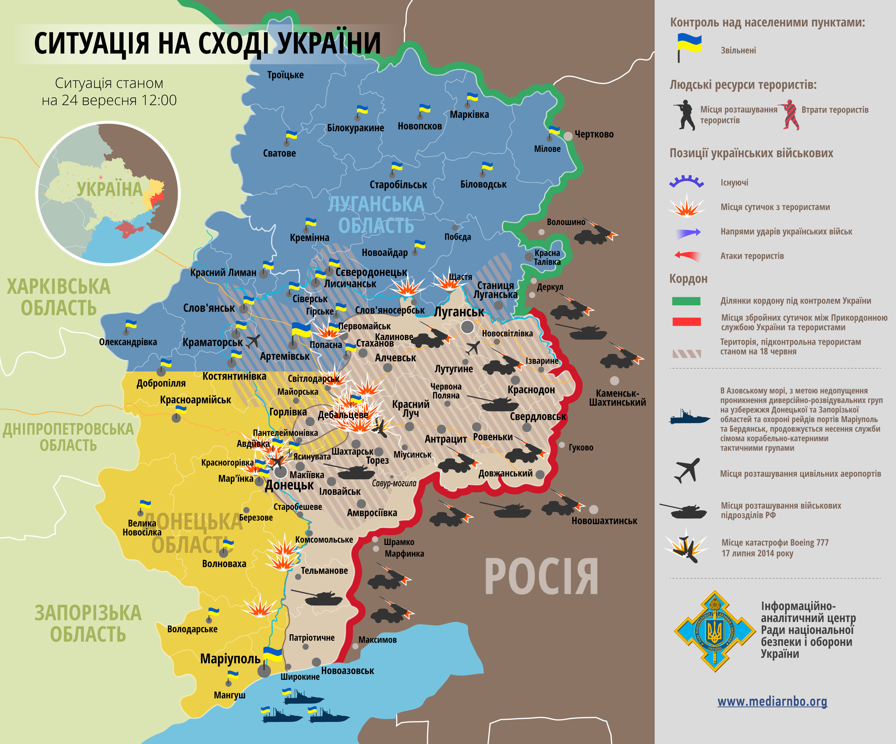
File:East Ukraine conflict (English language version).png has been listed at Commons:Deletion requests so that the community can discuss whether it should be kept or not. We would appreciate it if you could go to voice your opinion about this at its entry.
If you created this file, please note that the fact that it has been proposed for deletion does not necessarily mean that we do not value your kind contribution. It simply means that one person believes that there is some specific problem with it, such as a copyright issue. Please see Commons:But it's my own work! for a guide on how to address these issues. |
.png)
Vitez Kojo (talk) 15:55, 19 August 2014 (UTC)
.png)
SVG maps[edit]
Hi, I noticed you fixed the map for the war in eastern Ukraine and you actually did a pretty good job. I just wanted to ask you how to edit SVG maps and what program you use as I have been trying for a very long time but could never do it. --Leftcry (talk) 03:32, 30 August 2014 (UTC)
- @Leftcry: It's called Inkscape. You can download it easily in the internet. It was actually my 1st edition on an SVG file, and I've just started to learn. It was Ec.Domnowall that gave me a hint about how to edit SVG files, a few days ago.Mondolkiri1 (talk) 04:34, 30 August 2014 (UTC)
- I have Inkscape but I could never figure it out. --Leftcry (talk) 04:47, 30 August 2014 (UTC)
- It seems that whenever I try to edit an SVG image from Wikipedia it turns into pixels when I zoom in. --Leftcry (talk) 04:52, 30 August 2014 (UTC)
- @Leftcry: I guess the user that I told you about can figure that out better than me. I've just made one single edition (yesterday). That problem that you mentioned didn't happen to me, though.Mondolkiri1 (talk) 12:55, 30 August 2014 (UTC)
- It seems that whenever I try to edit an SVG image from Wikipedia it turns into pixels when I zoom in. --Leftcry (talk) 04:52, 30 August 2014 (UTC)
- I have Inkscape but I could never figure it out. --Leftcry (talk) 04:47, 30 August 2014 (UTC)
Situation in East Ukraine[edit]
Zhdanivka --- army withdrew from the city --- also rebels and Russian army controled the village Sofiivka In area of the city Lugansk, the Ukrainian troops almost left the city and its surroundings, moving away from his main forces to the north. In fact today they hold only a small bridgehead on the right bank of the Seversky Donets (Vesela Hora - Shyshkove - Dovhe).
- town Hlybokyi --- under control by rebels --- Also near Vesela Hora - Shchastia were intense battles, as well as near the Stanytsia Luhanska. Thus the rebels, with the support of the Russian army, acting in the direction of Krasnodon - Lugansk still managed to push the Ukrainian troops across the river Seversky Donets (except as noted above springboard). So that now both banks of the river are under control by Ukrainian troops only in area Katerinovka - Nyzhnie UA PressOdessa Daily
- Zemliane --- taken by rebels --- Mig NewsMig News112 UA--
- Schastia --- The Russian military now are very close to the city of Schastia the front line between the Ukrainian army and the armed forces of Russia lies in area of the bridge over the river of Seversky Donets --- Source
- Krasnoarmiisk --- Ukrainian army left the city --- PodrobnostiIBRA UAMelitopol NewsDialog Inform
- Also clashes near city Avdiivka and in the city Debaltseve.source--Hanibal911 (talk) 20:43, 7 September 2014 (UTC)
- Krasnoarmiisk --- Ukrainian army left the city --- PodrobnostiIBRA UAMelitopol NewsDialog Inform
- Schastia --- The Russian military now are very close to the city of Schastia the front line between the Ukrainian army and the armed forces of Russia lies in area of the bridge over the river of Seversky Donets --- Source
- city Sartana --- unclear situation --- sourcesourcesource--Hanibal911 (talk) 20:58, 7 September 2014 (UTC)
I'll only make the changes concerning to the places where sources are provided. Thank you for the informations!Mondolkiri1 (talk) 23:56, 7 September 2014 (UTC)
- Some of the changes, I think had already been made. I made changes based on UA Press and Odessa Daily (south side of Seversky Donets river) and [1] (fighting in Debaltseve, which, curiously, noone had told me here).Mondolkiri1 (talk) 01:26, 8 September 2014 (UTC)
- city Sartana and village Kominternove--- under control by pro Russian rebels --- UNIAN--Hanibal911 (talk) 06:36, 8 September 2014 (UTC)
- I've read the source and I'll turn Sartana red. I won't add the village, since it's already in the pink zone, and it's not very helpful to add every village that there is in the Donbass region.Mondolkiri1 (talk) 07:19, 8 September 2014 (UTC)
- Debaltseve --- The Russian troops or the rebels now start surround the Ukrainian troops in city Debaltseve now they are 300 meters away from position the Ukrainian army --- UNIAN--Hanibal911 (talk) 12:15, 8 September 2014 (UTC)
- Debaltseve is already in orange Mondolkiri1 (talk) 12:52, 8 September 2014 (UTC)
- Debaltseve --- The Russian troops or the rebels now start surround the Ukrainian troops in city Debaltseve now they are 300 meters away from position the Ukrainian army --- UNIAN--Hanibal911 (talk) 12:15, 8 September 2014 (UTC)
- I've read the source and I'll turn Sartana red. I won't add the village, since it's already in the pink zone, and it's not very helpful to add every village that there is in the Donbass region.Mondolkiri1 (talk) 07:19, 8 September 2014 (UTC)
- city Sartana and village Kominternove--- under control by pro Russian rebels --- UNIAN--Hanibal911 (talk) 06:36, 8 September 2014 (UTC)
- VorovskeKrasnopilliaTelmanove --- taken by pro Russian rebels --- 112 UA--Hanibal911 (talk) 18:03, 8 September 2014 (UTC)
- I change Telmanove to red, because the others are already red or are small villages in pink areas. I guess the map of Vorovske you indicated to me is not the right one, because is deep inside the yellow area, and there is another Vorovske in the pink area.Mondolkiri1 (talk) 22:53, 8 September 2014 (UTC)
- Ukraine's armed forces left the settlements Pryvitne, Pankovo, Stukalova Balka, Svitle, Obozne and Khrystove. Army also withdraw its troops from the liberated settlements Markivka, Novopskov, Belovodsk, Novojdar, Severodonetsk Starobilsk and Svatovo This is due to a truce, which was signed in Minsk between militants and Ukraine. source--Hanibal911 (talk) 21:29, 8 September 2014 (UTC)
- @Hanibal911: The word "liberated" expresses your POV, which I'd be glad you'd avoid to use. But your sources are very welcome! I'll check this one. Thanks!Mondolkiri1 (talk) 23:28, 8 September 2014 (UTC)
- Thank you very much! They're all in the yellow area, so there are no changes to be made!Mondolkiri1 (talk) 23:28, 8 September 2014 (UTC)
- Yellow circle south of Petrovske, west of Ivanivka and east of Hrushove need removed because previously the militants took control of the all south of Luhansk region.Mariupol NewsLiga NetGazeta UA--Hanibal911 (talk) 05:54, 9 September 2014 (UTC)
- Done! Thank you for the sources!Mondolkiri1 (talk) 07:09, 9 September 2014 (UTC)
- Yellow circle south of Petrovske, west of Ivanivka and east of Hrushove need removed because previously the militants took control of the all south of Luhansk region.Mariupol NewsLiga NetGazeta UA--Hanibal911 (talk) 05:54, 9 September 2014 (UTC)
- Thank you very much! They're all in the yellow area, so there are no changes to be made!Mondolkiri1 (talk) 23:28, 8 September 2014 (UTC)
- @Hanibal911: The word "liberated" expresses your POV, which I'd be glad you'd avoid to use. But your sources are very welcome! I'll check this one. Thanks!Mondolkiri1 (talk) 23:28, 8 September 2014 (UTC)
- Debalcevo --- Half of the city Debalcevo controlled by insurgents --- Ukrainian military are now located under Debalcevo on a narrow strip of land on both sides surrounded by gunmen. Them all the time shell terrorists.Gordon UALB UAsource--Hanibal911 (talk) 12:27, 10 September 2014 (UTC)
- Debalceve is orange now, but thank you very much for the information. I'll check the sources to see if there is any further information.Mondolkiri1 (talk) 15:10, 10 September 2014 (UTC)
- Here more confirmation about that Ukrainian troops now besieged by gunmen under Debalcevo.ObozrevatelGlavcomIpress UANV UAUkrinform--Hanibal911 (talk) 21:08, 10 September 2014 (UTC)
- @Hanibal911: I used the LB.ua and the finobzor sources. They're "surrounded on a narrow strip of land", so I updated the pink area North of Debaltseve. Vuhlehirs'k and Chornukhyne also belong to that strip of land?Mondolkiri1 (talk) 09:42, 11 September 2014 (UTC)
- Here more confirmation about that Ukrainian troops now besieged by gunmen under Debalcevo.ObozrevatelGlavcomIpress UANV UAUkrinform--Hanibal911 (talk) 21:08, 10 September 2014 (UTC)
- Debalceve is orange now, but thank you very much for the information. I'll check the sources to see if there is any further information.Mondolkiri1 (talk) 15:10, 10 September 2014 (UTC)
- Maybe! Aslo city Yasynuvata --- completely under control by insurgents --- Gordon UaDepo UA--Hanibal911 (talk) 10:07, 11 September 2014 (UTC)
- I'm very sorry for the dogs. But the last news I read, from yesterday, said that (at least yesterday) there was fighting in Yasynuvata.Mondolkiri1 (talk) 10:31, 11 September 2014 (UTC)
- You are not quite right! UNIAN not said that clashes in the city Yasynuvata they only said about shelling near city Yasynuvata.here--Hanibal911 (talk) 12:59, 11 September 2014 (UTC)
- @Hanibal911: Yes, the translation says nearby, actually: "Зокрема зафіксовані обстріли неподалік населених пунктів Дебальцеве, Ольхівка, Авдіївка, Ясинувата, Красногорівка, Кіровське, Майорськ, Малоорлівка." which I translated on Google translator. So, is the yellow zone South of Horlivka right? I picked the places of those towns and edited accordingly widing the yellow area to also include Vilkhivka, Maloorlivka and Kirovske. I also turned Yasynuvata orange (from red), and Krasnohorivka also orange (from blue). Which fixes were right and which fixes were wrong? Do you have further sources about Yasynuvata or any other of these places? If you give me one that is not about dogs, maybe it's more credible.Mondolkiri1 (talk) 15:37, 11 September 2014 (UTC)
- Donetsk airport --- militants launched an assault on the Donetsk airport --- UNIAN--Hanibal911 (talk) 20:53, 12 September 2014 (UTC)
- @Hanibal911: Yes, the translation says nearby, actually: "Зокрема зафіксовані обстріли неподалік населених пунктів Дебальцеве, Ольхівка, Авдіївка, Ясинувата, Красногорівка, Кіровське, Майорськ, Малоорлівка." which I translated on Google translator. So, is the yellow zone South of Horlivka right? I picked the places of those towns and edited accordingly widing the yellow area to also include Vilkhivka, Maloorlivka and Kirovske. I also turned Yasynuvata orange (from red), and Krasnohorivka also orange (from blue). Which fixes were right and which fixes were wrong? Do you have further sources about Yasynuvata or any other of these places? If you give me one that is not about dogs, maybe it's more credible.Mondolkiri1 (talk) 15:37, 11 September 2014 (UTC)
- You are not quite right! UNIAN not said that clashes in the city Yasynuvata they only said about shelling near city Yasynuvata.here--Hanibal911 (talk) 12:59, 11 September 2014 (UTC)
- I'm very sorry for the dogs. But the last news I read, from yesterday, said that (at least yesterday) there was fighting in Yasynuvata.Mondolkiri1 (talk) 10:31, 11 September 2014 (UTC)
- Lysychans'k, Debal'tseve, Volnovakha --- Russian troops and rebels send military equipment and fighters to the area towns of Lysychansk, Debalcevo and Volnovakha --- The concentration of enemy troops marked in area towns of Lisichansk and Debalcevo. Also carried shipping of militants and heavy equipment of the enemy in the direction the city of Volnovaha. In addition, according data from activist Dmitriy Tymchuk, rebels carried out constant attacks on positions of Ukrainian troops in the area the city Schastya.24 TVLB UALiga Net--Hanibal911 (talk) 12:18, 16 September 2014 (UTC)
- @Hanibal911: I'll check those sources a little bit later. According to the source you gave about Pervomaisk, also Zolote, Hirs'ke and Stanytsia Luhanska are occupied by the insurgents, if I understood well.Mondolkiri1 (talk) 15:34, 16 September 2014 (UTC)
- Yasynuvata --- Ukrainian troops lost checkpoint near city Yasynuvata and retreated a few kilometers --- DialogPodrobnosti UA Hanibal911 (talk) 10:27, 17 September 2014 (UTC)
- @Hanibal911: I asked you about Zolote, Hirs'ke and Stanytsia Luhanska, concerning to the source you've provided to paint Pervomaisk in red again: are Zolote, Hirs'ke and Stanytsia Luhanska also occupied by the insurgents? And, by the way (at least for me), you don't need to refer to the rebels as the evil ones against the good ones. I'm neutral and I think both sides have antagonist, though legitimate positions about the issue. You didn't answer to me about the question I posed to you! Unless you can provide me a consistent answer answer about Zolote, Hirs'ke and Stanytsia Luhanska, I'll be quite blind about the situation in these 3 towns. Because I translated the sources in Google Translator and Paralink translator (I'm a Portuguese (latin) with a good knowledge of English and Spanish and some knowledge about Italian and French). Pervomaisk, by what I've understood, is in the same situation of Zolote, Hirs'ke (or is it another place?) and Stanytsia Luhanska. I have to be consistent in the maps that I edit from the sources you provide to me (and others that I get). So far, I've only kept Pervomaisk as red, but according to your source, if I'm not wrong, at least Zolote and Stanytsia Luhanska should also be red. Only after you (or someone else) reply to this question (preferably with more sources about Pervomaisk, Zolote and Stanytsia Luhanska), I will do a later update. I have to be accurate according to the sources that are provided and I update the map according to them, if they seem to be reliable enough, taking into account the "fog of war". I'll quote this answer in both maps involved. Mondolkiri1 (talk) 04:27, 18 September 2014 (UTC)
- I think it would be better for now to note these cities (Zolote, Hirs'ke and Stanytsia Luhanska) in orange color. This would be the best solution as long as we are not fully clarify the situation. Regards!--Hanibal911 (talk) 06:44, 18 September 2014 (UTC)
- Thanks! I'll paint them grey in the "Russian military intervention" article.Mondolkiri1 (talk) 07:10, 18 September 2014 (UTC)
- @Hanibal911: No, sorry, in that case I have to paint them in red. I have to be consistent with the source! If there are conflicting sources, I'll paint them in grey.Mondolkiri1 (talk) 07:25, 18 September 2014 (UTC)
- Thanks! I'll paint them grey in the "Russian military intervention" article.Mondolkiri1 (talk) 07:10, 18 September 2014 (UTC)
- I think it would be better for now to note these cities (Zolote, Hirs'ke and Stanytsia Luhanska) in orange color. This would be the best solution as long as we are not fully clarify the situation. Regards!--Hanibal911 (talk) 06:44, 18 September 2014 (UTC)
- @Hanibal911: I asked you about Zolote, Hirs'ke and Stanytsia Luhanska, concerning to the source you've provided to paint Pervomaisk in red again: are Zolote, Hirs'ke and Stanytsia Luhanska also occupied by the insurgents? And, by the way (at least for me), you don't need to refer to the rebels as the evil ones against the good ones. I'm neutral and I think both sides have antagonist, though legitimate positions about the issue. You didn't answer to me about the question I posed to you! Unless you can provide me a consistent answer answer about Zolote, Hirs'ke and Stanytsia Luhanska, I'll be quite blind about the situation in these 3 towns. Because I translated the sources in Google Translator and Paralink translator (I'm a Portuguese (latin) with a good knowledge of English and Spanish and some knowledge about Italian and French). Pervomaisk, by what I've understood, is in the same situation of Zolote, Hirs'ke (or is it another place?) and Stanytsia Luhanska. I have to be consistent in the maps that I edit from the sources you provide to me (and others that I get). So far, I've only kept Pervomaisk as red, but according to your source, if I'm not wrong, at least Zolote and Stanytsia Luhanska should also be red. Only after you (or someone else) reply to this question (preferably with more sources about Pervomaisk, Zolote and Stanytsia Luhanska), I will do a later update. I have to be accurate according to the sources that are provided and I update the map according to them, if they seem to be reliable enough, taking into account the "fog of war". I'll quote this answer in both maps involved. Mondolkiri1 (talk) 04:27, 18 September 2014 (UTC)
- Yasynuvata --- Ukrainian troops lost checkpoint near city Yasynuvata and retreated a few kilometers --- DialogPodrobnosti UA Hanibal911 (talk) 10:27, 17 September 2014 (UTC)
- Pervomaisk --- under control by pro-Russian rebels --- Espreso TVInformator
- Donetsk --- also inder control by insurgents --- clashes only in Donetsk airport.UNIAN --Hanibal911 (talk) 11:53, 18 September 2014 (UTC)
- I asked for help from the administrator and he temporarily set protection on the map so that no one except the admins could not edit it.--Hanibal911 (talk) 15:32, 18 September 2014 (UTC)
- Army today left the several cities including Zhdanivka, Yunokomunarivsk, Rozivka, Vuhlehirsk.24TV UALB UA--Hanibal911 (talk) 07:11, 21 September 2014 (UTC)
- I asked for help from the administrator and he temporarily set protection on the map so that no one except the admins could not edit it.--Hanibal911 (talk) 15:32, 18 September 2014 (UTC)
- Donetsk --- also inder control by insurgents --- clashes only in Donetsk airport.UNIAN --Hanibal911 (talk) 11:53, 18 September 2014 (UTC)
- @Hanibal911: I'll check those sources a little bit later. According to the source you gave about Pervomaisk, also Zolote, Hirs'ke and Stanytsia Luhanska are occupied by the insurgents, if I understood well.Mondolkiri1 (talk) 15:34, 16 September 2014 (UTC)
- Dokuchaevsk --- under control by pro Russian rebels --- Dialog UA--Hanibal911 (talk) 18:52, 21 September 2014 (UTC)
- Correct the error on the map because city Vuhlehirsk, Rozivka --- under control by rebels --- Dialog UA24TV--Hanibal911 (talk) 22:28, 21 September 2014 (UTC)
- Kuteinykove --- under control by Russain troops --- source--Hanibal911 (talk) 22:36, 21 September 2014 (UTC)
- I found the situation in Kuteinykove in the military map a bit weird, since it was red before and it's deep inside the pink zone. I'll check that. And also about Vuhlehirsk and Rozivka. Thank you a lot for the sources.Mondolkiri1 (talk) 22:42, 21 September 2014 (UTC)
- So also Mar'inka --- under control by rebels --- 112 UA Also fix the map in the area city Debalcevo because the most part this area under the control of militants and now they are attacking army positions in the town Debalcevo and Chornukhyno.ObozrevatelPodrobnosti UA And in late August, the Ukrainian army completely retreat from the Starobeshevskiy area source--Hanibal911 (talk) 22:56, 21 September 2014 (UTC)
- Hanibal911 I corrected Kuteinykove, Vuhlehirsk and Chornukhyne based on those sources. I didn't correct Mar'inka, because it only talks about a checkpoint near Mar'inka, not the city of Mar'inka itself.Mondolkiri1 (talk) 23:26, 21 September 2014 (UTC)
- So also Mar'inka --- under control by rebels --- 112 UA Also fix the map in the area city Debalcevo because the most part this area under the control of militants and now they are attacking army positions in the town Debalcevo and Chornukhyno.ObozrevatelPodrobnosti UA And in late August, the Ukrainian army completely retreat from the Starobeshevskiy area source--Hanibal911 (talk) 22:56, 21 September 2014 (UTC)
- I found the situation in Kuteinykove in the military map a bit weird, since it was red before and it's deep inside the pink zone. I'll check that. And also about Vuhlehirsk and Rozivka. Thank you a lot for the sources.Mondolkiri1 (talk) 22:42, 21 September 2014 (UTC)
- Kuteinykove --- under control by Russain troops --- source--Hanibal911 (talk) 22:36, 21 September 2014 (UTC)
- The area around the city Debalcevo under the control of militants and in this area Ukrainian troops in besiege with the four side inside the cities Debalcevo and Chornukhyne. So that we need left in orange color the city of Debalcevo and the city Chornukhyne but the other cities and villages in this area need put in red color.Dialog UA--Hanibal911 (talk) 08:12, 22 September 2014 (UTC)
- Also pro-Russian rebels launched offensive in toward the city Mariupol. Violent clashes in the area of the 13 and 14 checkpoints.InfoResist--Hanibal911 (talk) 08:49, 22 September 2014 (UTC)
- Correct the error on the map because city Vuhlehirsk, Rozivka --- under control by rebels --- Dialog UA24TV--Hanibal911 (talk) 22:28, 21 September 2014 (UTC)
- update data :
- Avdiivka --- under control by insurgents --- Ukrainian troops retreated from the city. ::::: * Marinka and Krasnogorovka --- Ukrainian military began to retreat from the cities --- source--Hanibal911 (talk) 11:37, 22 September 2014 (UTC)
- The last source you gave to me said what DNR reports. It may not be reliable enough. I consulted http://militarymaps.info/ . There is fighting in a lot of places in the Debaltseve area, including in Vuhlehirsk. The centre of the city of Debaltseve seems to be under rebel control now, but there is fighting around, so I kept it orange. In 3 places where there were not indications of fighting, I kept them blue, by now. I changed Avdiivka to orange, Marinka to red and Shyrokyne also to red. I also changed Pavlopil to red, since it's inside the pink zone and there haven't been indications of fighting there. And I moved the yellow/pink borther to the West, in Krasnohorivka, since it it shows one part of the city rebel control, another under government control, but I didn't see any indication of fighting there, so by now, for caution, I kept it blue. The source about Mariupol talks about checkpoints with numbers, I don't know where those are, but according to http://militarymaps.info/ there isn't yet any fighting inside the city of Mariupol.Mondolkiri1 (talk) 17:35, 22 September 2014 (UTC)
- Vuhlehirsk --- under control by insurgents --- Ukrainian official sources clear said that Forces of the anti-terrorist operation gone from a number of localities around Yenakijevo - Zhdanivka (here already disrupted Ukrainian flag) Yunokomunarivsk, Verkhnia Krynka, Nyzhnia Krynka, Rozivka and Vuhlehirsk.24TVInforesistsourceATN UAUkr InformSociety LB UAFocus UA--Hanibal911 (talk) 19:27, 22 September 2014 (UTC)
- Maloorlivka --- under control by insurgents --- In the village of Maloorlivka now not present the Ukrainian troops.UkrinformIpress UA--Hanibal911 (talk) 19:49, 22 September 2014 (UTC)
- I revert to the correct version of the map because http://liveuamap.com it is not reliable source based on posts in Twitter so you can again mark the Kaliningrad in the little map - how part of Russia.--Hanibal911 (talk) 09:10, 25 September 2014 (UTC)
- Maloorlivka --- under control by insurgents --- In the village of Maloorlivka now not present the Ukrainian troops.UkrinformIpress UA--Hanibal911 (talk) 19:49, 22 September 2014 (UTC)
- Vuhlehirsk --- under control by insurgents --- Ukrainian official sources clear said that Forces of the anti-terrorist operation gone from a number of localities around Yenakijevo - Zhdanivka (here already disrupted Ukrainian flag) Yunokomunarivsk, Verkhnia Krynka, Nyzhnia Krynka, Rozivka and Vuhlehirsk.24TVInforesistsourceATN UAUkr InformSociety LB UAFocus UA--Hanibal911 (talk) 19:27, 22 September 2014 (UTC)
- The last source you gave to me said what DNR reports. It may not be reliable enough. I consulted http://militarymaps.info/ . There is fighting in a lot of places in the Debaltseve area, including in Vuhlehirsk. The centre of the city of Debaltseve seems to be under rebel control now, but there is fighting around, so I kept it orange. In 3 places where there were not indications of fighting, I kept them blue, by now. I changed Avdiivka to orange, Marinka to red and Shyrokyne also to red. I also changed Pavlopil to red, since it's inside the pink zone and there haven't been indications of fighting there. And I moved the yellow/pink borther to the West, in Krasnohorivka, since it it shows one part of the city rebel control, another under government control, but I didn't see any indication of fighting there, so by now, for caution, I kept it blue. The source about Mariupol talks about checkpoints with numbers, I don't know where those are, but according to http://militarymaps.info/ there isn't yet any fighting inside the city of Mariupol.Mondolkiri1 (talk) 17:35, 22 September 2014 (UTC)
A barnstar for you![edit]

|
The Graphic Designer's Barnstar |
| This you for your work of update the map! Hanibal911 (talk) 15:35, 18 September 2014 (UTC) |
@Hanibal911: Oh, thank you very much! 3 weeks ago I didn't have the foggiest idea about how to edit SVG files, but User:Ec.Domnowall told me how to do it, and I've been learning quickly, fortunately. And I also thank you very much for all the sources you have provided to me!Mondolkiri1 (talk) 16:19, 18 September 2014 (UTC)
Schastya[edit]
Schastya is under the the control of the Aidar Battalion. Sources:https://twitter.com/azavodyuk/status/513770107739578368,http://darkroom.baltimoresun.com/2014/09/daily-brief-september-20/#2
- I already corrected that, indicating a Belarusian and a Ukrainian source. I'll check if anyone reverted it.Mondolkiri1 (talk) 16:09, 22 September 2014 (UTC)
- "The hot spots" in the Donbas are city Schastya and Donetsk airport - NSDC.Korrespondent.netDialog UADelo UA--Hanibal911 (talk) 19:34, 22 September 2014 (UTC)
- The Donetsk Airport is already orange. The Debaltseve region is mostly orange. And if that's the case, then Schasya shall be also in orange! Thank you again for your very valuable sources! (I'm not taking sides, as I said previously, I only edit according to the sources). Mondolkiri1 (talk) 03:22, 23 September 2014 (UTC)
- But cities:
- "The hot spots" in the Donbas are city Schastya and Donetsk airport - NSDC.Korrespondent.netDialog UADelo UA--Hanibal911 (talk) 19:34, 22 September 2014 (UTC)
- Maloorlivka - must be marked in red color.UkrinformIpress UA
- Vuhlehirsk - must be marked in red color.InforesistsourceATN UAUkr InformSociety LB UAFocus UA--Hanibal911 (talk) 07:04, 23 September 2014 (UTC)
East Ukraine map[edit]
Hi, if you are going to use pro-Kiev sources for Kiev forces advances, I would have to start using pro-rebel sources for Novorossiyan advances, logically. Also I would like to know why you find http://liveuamap.com/ unreliable but at the same time consider http://militarymaps.info/ as reliable. Regards,--HCPUNXKID (talk) 15:58, 25 September 2014 (UTC)
Also, it has no sense to have Luhanske in blue but at the same time with its southern half surrounded by pink. As far as I know, only towns in orange could be like that, so please put the surrounding of Luhanske in yellow (as I did) or put Luhanske in orange.--HCPUNXKID (talk) 16:08, 25 September 2014 (UTC)
Another thing you have to explain me is why you think that the http://militarymaps.info/ is dominant over news reports, as you did by changing Svitlodars'k status denying its lost by Ukrainian forces, something based on ATO-RNBO source!. And finally, I will remove that cauldrons without towns you added, as no other map (pro-rebel or pro-government, including the ATO one) recognize its existence.--HCPUNXKID (talk) 16:19, 25 September 2014 (UTC)
- It seems I was wrong about the cauldrons, as some pro-rebel maps recognize their existence, so add them again to the map if you want. But still I cant understand why you only added two cauldrons when according to http://militarymaps.info/ there are four of them...--HCPUNXKID (talk) 17:03, 25 September 2014 (UTC)
- HCPUNXKID So, according to you, http://liveuamap.com/ is a pro-rebel source?? Have you seen well http://liveuamap.com/? Concerning to http://militarymaps.info/, I don't know for which side it stands (though it's in Russian, but that per se doesn't mean anything). http://militarymaps.info/ is more detailed, that's why I've used it, and Hanibal911 has given another reason to change it back. I use the sources, regardless of what they are pro or anti, given that their information is the most accurate that is possible in the fog of war. It wasn't me, by the way, who changed it back to the map that is more based on http://militarymaps.info/ than on http://liveuamap.com/, it was Hanibal911 and he explained why. Concerning to Svitlodars'k I'll consult the source. And concerning to Luhanske, the city is in a kind of a foggy area, that goes all the way until Debaltseve, but I can't paint it both pink and yellow, and I've had no information that Luhanske has changed from one side to the other! Mondolkiri1 (talk) 17:09, 25 September 2014 (UTC)
- Hola, mira, creo q no me has entendido. No digo ni he dicho q estés a favor de uno u otro bando, ni tampoco he dicho en ningún momento q http://liveuamap.com/ sea una fuente pro-rebelde, está claro q es una fuente pro-Kiev. Lo q digo es q no entiendo q pongas a http://militarymaps.info/ (q por lo poco q he visto -no entiendo ruso- no deja de ser un proyecto colaborativo) por encima de fuentes periodísticas, como si fuera una fuente 100% creíble por encima del resto. Eso sí, visto q otros usuarios la usáis, no voy a ser menos y también he empezado a usarla, lógicamente. En cuanto a Svitlodars'k, la fuente (tanto la primera vez q lo cambié como esta última) es el mapa realizado por el National Security and Defense Council of Ukraine, una fuente oficial del gobierno de Kiev. Por lo tanto creo q si el bando pro-Kiev reconoce q esa ciudad está en manos rebeldes o al menos q hay combates en esa localidad, es + creíble q lo q diga http://militarymaps.info/ (Por ejemplo, en el mapa de la guerra civil siria aceptamos los avances de un bando cuando es el otro bando o una fuente neutral la q los reconoce. Creo q es una buena manera de evitar el agit-prop de la guerra). Y en cuanto a Luhanske, lo q digo es q si la ciudad está en azul no tiene sentido q esté medio rodeada de rosa, ya q el resto de ciudades de azul están rodeadas de amarillo, y siempre lo han estado en este mapa. Lo lógico es q si está en manos del gobierno de Kiev los alrededores estén en amarillo, y si no, si está medio rodeada de rosa, la ciudad debería estar en naranja (como en el caso de Avdiivka o Krasnohorivka).Saludos cordiales,--HCPUNXKID (talk) 18:17, 25 September 2014 (UTC)
- HCPUNXKID En la fuente que has dado, Svitlodars'k está en la frontera entre los dos lados del conflicto. No dice alla que está en manos de los rebeldes. No indica, tampoco, que haya alguna confrontación en ese lugar. Como en el otro mapa está indicada como estando en manos de las fuerzas gobernamentales, hace mas sentido ponerla en azul. No encuentro razones para disputar los otros cambios que hiciste en el mapa. Saludos cordiales.Mondolkiri1 (talk) 18:29, 25 September 2014 (UTC)
- En este mapa de ayer -24 Septiembre- de la misma fuente oficial de Kiev, Svitlodarsk se muestra con combates, por lo tanto es lógico ponerla en naranja en vez de azul, ya q si hubiera sido conquistada x las tropas de Kiev tendríamos otras fuentes q lo confirmarían. Además, si estuviera en manos de Kiev estaría en el mapa como Kalynove, en territorio recuperado a los rebeldes y con la bandera ucraniana, y no es así.--HCPUNXKID (talk) 18:43, 25 September 2014 (UTC)
- HCPUNXKID Muestra combates muy cerca de Svitlodarsk, pero como saber si es mismo en esa aldea o villa? Hay mas alguna fuente? Es que Luhanske también es muy cerca de Svitlodarsk y no aparece en ese mapa!Mondolkiri1 (talk) 18:52, 25 September 2014 (UTC)
- En este mapa de ayer -24 Septiembre- de la misma fuente oficial de Kiev, Svitlodarsk se muestra con combates, por lo tanto es lógico ponerla en naranja en vez de azul, ya q si hubiera sido conquistada x las tropas de Kiev tendríamos otras fuentes q lo confirmarían. Además, si estuviera en manos de Kiev estaría en el mapa como Kalynove, en territorio recuperado a los rebeldes y con la bandera ucraniana, y no es así.--HCPUNXKID (talk) 18:43, 25 September 2014 (UTC)
- HCPUNXKID En la fuente que has dado, Svitlodars'k está en la frontera entre los dos lados del conflicto. No dice alla que está en manos de los rebeldes. No indica, tampoco, que haya alguna confrontación en ese lugar. Como en el otro mapa está indicada como estando en manos de las fuerzas gobernamentales, hace mas sentido ponerla en azul. No encuentro razones para disputar los otros cambios que hiciste en el mapa. Saludos cordiales.Mondolkiri1 (talk) 18:29, 25 September 2014 (UTC)
- Hola, mira, creo q no me has entendido. No digo ni he dicho q estés a favor de uno u otro bando, ni tampoco he dicho en ningún momento q http://liveuamap.com/ sea una fuente pro-rebelde, está claro q es una fuente pro-Kiev. Lo q digo es q no entiendo q pongas a http://militarymaps.info/ (q por lo poco q he visto -no entiendo ruso- no deja de ser un proyecto colaborativo) por encima de fuentes periodísticas, como si fuera una fuente 100% creíble por encima del resto. Eso sí, visto q otros usuarios la usáis, no voy a ser menos y también he empezado a usarla, lógicamente. En cuanto a Svitlodars'k, la fuente (tanto la primera vez q lo cambié como esta última) es el mapa realizado por el National Security and Defense Council of Ukraine, una fuente oficial del gobierno de Kiev. Por lo tanto creo q si el bando pro-Kiev reconoce q esa ciudad está en manos rebeldes o al menos q hay combates en esa localidad, es + creíble q lo q diga http://militarymaps.info/ (Por ejemplo, en el mapa de la guerra civil siria aceptamos los avances de un bando cuando es el otro bando o una fuente neutral la q los reconoce. Creo q es una buena manera de evitar el agit-prop de la guerra). Y en cuanto a Luhanske, lo q digo es q si la ciudad está en azul no tiene sentido q esté medio rodeada de rosa, ya q el resto de ciudades de azul están rodeadas de amarillo, y siempre lo han estado en este mapa. Lo lógico es q si está en manos del gobierno de Kiev los alrededores estén en amarillo, y si no, si está medio rodeada de rosa, la ciudad debería estar en naranja (como en el caso de Avdiivka o Krasnohorivka).Saludos cordiales,--HCPUNXKID (talk) 18:17, 25 September 2014 (UTC)
The source for coloring Svitlodars'k in orange is: http://www.rnbo.gov.ua/files/2014/24-09.jpg (it can't be seen until the end in the edition made by User:HCPUNXKID) Mondolkiri1 (talk) 19:05, 25 September 2014 (UTC)
- Clashes in the village Petrivka and near city Novoaidar.News 24UA--Hanibal911 (talk) 14:06, 26 September 2014 (UTC)
- You are not correctly note on the map the city of Petrivka. The source said about this city here.--Hanibal911 (talk) 18:21, 26 September 2014 (UTC)
- Oh, sorry... I confused, because then, there are 2 Petrivkas. But that Petrivka isn't shown on this map, only Schastya. Mondolkiri1 (talk) 19:07, 26 September 2014 (UTC)
- OK, I've corrected it. Mondolkiri1 (talk) 19:42, 26 September 2014 (UTC)
- Pro government sources clear said that army retreated from city Vuhlehirs'k on 20 September so stop and more not says that army again retake city.24TV UAATN--Hanibal911 (talk) 07:17, 1 October 2014 (UTC)
- Citys Vuhlehirs'k and Chornukhyne under control the insurgents and of these settlements they shell the city Debaltseve.Gazeta UATSNFakty UA--Hanibal911 (talk) 07:34, 1 October 2014 (UTC)
- Pro government sources clear said that army retreated from city Vuhlehirs'k on 20 September so stop and more not says that army again retake city.24TV UAATN--Hanibal911 (talk) 07:17, 1 October 2014 (UTC)
- You are not correctly note on the map the city of Petrivka. The source said about this city here.--Hanibal911 (talk) 18:21, 26 September 2014 (UTC)
- According to pro government source the village Starohnativka now in besieged by pro-Russian fighters and they shelled her from heavy artillery.Also the city Debaltseve in besieged with three side and also under fire.112 UA--Hanibal911 (talk) 18:36, 1 October 2014 (UTC)
- Hanibal911Do you have a source about Starohnativka?. The source you gave to me talks about Schastya, Popasna, Slavianosebersk, Avdiivka, Marinka, Maiorska and Volnovakha (and in the Donetsk Airport and Debaltseve area), not Starohnahnativka. Is it in the map?Mondolkiri1 (talk) 20:38, 1 October 2014 (UTC)
- Video report in the bottom of the source and in this report said about Staroignatovke. Hanibal911 (talk) 06:51, 2 October 2014 (UTC)
- Also, if you look at this videoreport you will understand that this settlement is in the territory which is controlled by the militants. And that means that you need to expand the pink zone.--Hanibal911 (talk) 06:56, 2 October 2014 (UTC)
- Hanibal911 Yes, but it's the only source showing it inside the rebel-controlled zone. There is a large area nearby, to the Northeast, that according to militarymaps seems to be unclear about who controls it, but it doesn't include Starohnativka. I'm surprised how it's said that the truce is holding and the rebels, nevertheless, take a large chunk of Lysychansk, they're very engaged about taking the Donetsk Airport and everyday there's fight in the Debaltseve area.Mondolkiri1 (talk) 17:13, 2 October 2014 (UTC)
- Also, if you look at this videoreport you will understand that this settlement is in the territory which is controlled by the militants. And that means that you need to expand the pink zone.--Hanibal911 (talk) 06:56, 2 October 2014 (UTC)
- Video report in the bottom of the source and in this report said about Staroignatovke. Hanibal911 (talk) 06:51, 2 October 2014 (UTC)
- Hanibal911 Is Kurakhove still contested? There have been some weeks when I haven't heard anything about it!Mondolkiri1 (talk) 20:38, 1 October 2014 (UTC)
- Hanibal911Do you have a source about Starohnativka?. The source you gave to me talks about Schastya, Popasna, Slavianosebersk, Avdiivka, Marinka, Maiorska and Volnovakha (and in the Donetsk Airport and Debaltseve area), not Starohnahnativka. Is it in the map?Mondolkiri1 (talk) 20:38, 1 October 2014 (UTC)
Hanibal911 Could you provide any good and updated sources about the situation in Lysychansk and the Donetsk Airport? The informations I've consulted are often from some days ago, and the situation in those 2 places seems to be very confusing.Mondolkiri1 (talk) 17:45, 2 October 2014 (UTC)
Hanibal911 I've noticed that the http://www.rnbo.gov.ua/files/2014/03-10.jpg source shows the separatists controling almost all the way to Novomikhailivka, but temporarily militarymaps.info is unavailable for technical problems. So, I would have to turn Mykolaivkqa, Rybynske, Volnovakha (I turned it orange), Svobodne, Donskoye, Starohnativka (already orange), Hranitne (orange too), Andriivka and Myrne all red (or orange at least)! Clearly the Ukrainian official map has something wrong about it or it is right and neither them nor the Russians admit it! Could you clarify me a bit? I'm sorry to say, but you haven't been very quick answering my questions. I'd hope this would be a team work. Mondolkiri1 (talk) 01:42, 4 October 2014 (UTC) (02:42, 4 October 2014 Lisbon Time)
- Yes you are right that the official Ukrainian map has a lot of mistakes. And I'm sorry that I can not always respond in time! I'll try to find more information.--Hanibal911 (talk) 09:25, 4 October 2014 (UTC)
- Two the pro-Ukrainian maps show that the city Zolote is under the control of the pro-Russian rebels.herandher What do you think about this?--Hanibal911 (talk) 09:42, 4 October 2014 (UTC)
- Hanibal911 As long as militarymaps.org is not working, I'll paint it red (and pink around it). Concerning to Hirske, I'll consult the official map of the Ukrainian authorities to see what they say about it. And I'll ask again to militaymaps.org what's going on with their maps! Mondolkiri1 (talk) 02:58, 4 October 2014 (UTC) (03:57, 4 October 2014 London/Dublin/Lisbon/Casablanca Time)
- OK!--Hanibal911 (talk) 06:55, 5 October 2014 (UTC)
- Also according these pro-Ukrainian maps herehere these settlements (Maloorlivka,Orlovo-Ivanivka, Ol'khovatka, Bulavyns'k, Olenivka and Oleksandrivs'ke) near on souths city Vuhlehirsk now under control by pro-Russian insurgents.--Hanibal911 (talk) 10:51, 6 October 2014 (UTC)
- Hanibal911 Now militarymaps.info is working again. It displays the Donetsk Airport under rebel control. Is the fight over there? Concerning to the locations around Debaltselve, it shows them under Ukrainian control. If I was to follow those sources, I'd have to put Novotroitske, Styla, Dokuchajevsk, Marinka and even Stanytsa Luhanska in the yellow zone, which is not very realistic. Concerning to Zolote, militarymaps.info still shows it as being controlled by the Ukrainian forces, and mediarnbo is not very clear about who controls it. Do you have further information about Zolote? (Don't forget the question about the Airport either!)Mondolkiri1 (talk) 14:44, 6 October 2014 (UTC)
- Also according these pro-Ukrainian maps herehere these settlements (Maloorlivka,Orlovo-Ivanivka, Ol'khovatka, Bulavyns'k, Olenivka and Oleksandrivs'ke) near on souths city Vuhlehirsk now under control by pro-Russian insurgents.--Hanibal911 (talk) 10:51, 6 October 2014 (UTC)
- As soon as I find the more data I will give them to you! Also the data on this map (militarymaps.info) may be slightly outdated until the source was not working. I mean the area around city Debaltselve!--Hanibal911 (talk) 20:07, 6 October 2014 (UTC)
- still unclear situation with Chornukhyne.
- Debaltselve --- under conrol by insurgensts --- Governor of Luhansk region, said that the city Debaltselve is under the control of militants.Top MediaSegodnya UACity NewsLugan Radar--Hanibal911 (talk) 20:19, 6 October 2014 (UTC)
- Hanibal911 Well, I'll update the situation according to militaymaps.info and sources that I found in the Timeline of the war in Donbass. Those places where there has been fighting from 3 October on (according to those sources) or that are divided, like Zolote, I'll paint them orange. But I'll use that information to update the map in the File:2014_Russo-ukrainian-conflict_map.svg. Thanks a lot! Mondolkiri1 (talk) 21:55, 6 October 2014 (UTC)
- It was that same news on every source, and this news contradicts information from other sources. So, I painted it grey in File:2014_Russo-ukrainian-conflict_map.svg.Mondolkiri1 (talk) 23:38, 6 October 2014 (UTC)
- Hanibal911 Well, I'll update the situation according to militaymaps.info and sources that I found in the Timeline of the war in Donbass. Those places where there has been fighting from 3 October on (according to those sources) or that are divided, like Zolote, I'll paint them orange. But I'll use that information to update the map in the File:2014_Russo-ukrainian-conflict_map.svg. Thanks a lot! Mondolkiri1 (talk) 21:55, 6 October 2014 (UTC)
- Debaltselve --- under conrol by insurgensts --- Governor of Luhansk region, said that the city Debaltselve is under the control of militants.Top MediaSegodnya UACity NewsLugan Radar--Hanibal911 (talk) 20:19, 6 October 2014 (UTC)
- still unclear situation with Chornukhyne.
- This (Maloorlivka,Orlovo-Ivanivka, Ol'khovatka, Bulavyns'k, and Oleksandrivs'ke) settlements must not be displayed completely under the control of Ukrainian army since pro Ukrainian maps show them under the control of militants! Also if you noted Uglegorsk how contested it should still be in the pink zone. also city Starognatovka must remain contested. Hanibal911 (talk) 10:10, 7 October 2014 (UTC)
- Hanibal911 I have to be consistent with the sources I'm using, and militaymaps.info is, by far, the most detailed one. Also, in spite of being a Russian site, it hasn't been biased concerning to the control by each side. And if I was going to use those maps you've suggested I'd also have to make all those changes I mentioned above. If there is any change concerning to those villages or towns you mentioned you'd need to provide further sources that are not in the maps, like you provided about Debaltseve. Your suggestions have been always to suggest that the rebels are taking towns and losing none. In a war it's natural that there are advances here and retreats there. It's not a continuous movement. Also, take into account that I've mentioned that the sites where I've considered to be fighting are only those where there are reports of fighting from 3 October on. Mondolkiri1 (talk) 15:00, 7 October 2014 (UTC)
- Hanibal911 Do you have any information about Valuiske, next to Stanitsa Luhanska? According to militarymaps it's divided and it has no flag over it, though most of it is behind the Ukrainian forces front line.Mondolkiri1 (talk) 16:25, 7 October 2014 (UTC)
- I will try to find data about Valuiske!--Hanibal911 (talk) 20:21, 7 October 2014 (UTC)
- Svitlafar'sk --- contested ---Segodnya UA--Hanibal911 (talk) 20:33, 7 October 2014 (UTC)
- Hanibal911 According to that source "Over the weekend in the area Debaltsevo force ATO shifted its zone of control. Its center is now on Svetlodarsk and M03 motorway. But now the enemy again went on the offensive." Yes, but that source doesn't specify where in the zone the ATO control did they go on the offensive.
- Svitlafar'sk --- contested ---Segodnya UA--Hanibal911 (talk) 20:33, 7 October 2014 (UTC)
- I will try to find data about Valuiske!--Hanibal911 (talk) 20:21, 7 October 2014 (UTC)
- Hanibal911 Do you have any information about Valuiske, next to Stanitsa Luhanska? According to militarymaps it's divided and it has no flag over it, though most of it is behind the Ukrainian forces front line.Mondolkiri1 (talk) 16:25, 7 October 2014 (UTC)
- Hanibal911 I have to be consistent with the sources I'm using, and militaymaps.info is, by far, the most detailed one. Also, in spite of being a Russian site, it hasn't been biased concerning to the control by each side. And if I was going to use those maps you've suggested I'd also have to make all those changes I mentioned above. If there is any change concerning to those villages or towns you mentioned you'd need to provide further sources that are not in the maps, like you provided about Debaltseve. Your suggestions have been always to suggest that the rebels are taking towns and losing none. In a war it's natural that there are advances here and retreats there. It's not a continuous movement. Also, take into account that I've mentioned that the sites where I've considered to be fighting are only those where there are reports of fighting from 3 October on. Mondolkiri1 (talk) 15:00, 7 October 2014 (UTC)
- Novohnativka, Mykolaivka and Trudivske --- under control by insurgents --- according to Military Maps--Hanibal911 (talk) 21:07, 7 October 2014 (UTC)
- Hanibal911 Trudivske is a small village. I've been adding several small villages, since I thought they were important to specify where the control of one side begins and where the control of the other side ends. I haven't seen information of fighting in that village, so, by now, I just corrected Novohnativka, Mykolaivka and the pink zone where Trudivske is.Mondolkiri1 (talk) 00:16, 9 October 2014 (UTC)
- Hanibal911 I also added Trudivske, since in the border.Mondolkiri1 (talk) 00:48, 9 October 2014 (UTC)
- Hanibal911 Trudivske is a small village. I've been adding several small villages, since I thought they were important to specify where the control of one side begins and where the control of the other side ends. I haven't seen information of fighting in that village, so, by now, I just corrected Novohnativka, Mykolaivka and the pink zone where Trudivske is.Mondolkiri1 (talk) 00:16, 9 October 2014 (UTC)
- Chornukhyne, Nikishyne, Smile --- under conrol by rebels --- according Military Maps--Hanibal911 (talk) 15:43, 8 October 2014 (UTC)
- Hanibal911 Since I've considered now as fighting area wherever there were fights from 5 October on, I've still painted Nikishyne as orange. The others I painted them red.Mondolkiri1 (talk) 00:16, 9 October 2014 (UTC)
- Novotroitske, Mar'inka, Krasnyi Partyzan --- under control the insurgents --- Krasnohorivka --- under control by army --- Military Maps--Hanibal911 (talk) 14:10, 9 October 2014 (UTC)
- Hanibal911 I change Novotroitske and Mar'inka again, since I only painted them orange because there were contradictory informations in militarymaps.info. Krasnyi Partyzan, if it's the one near Horlivka is already in the pink zone, and that area is already too filled with towns and villages to add yet another one. Concerning to Krasnohorivka, there has been actual fighting there from 5 October on, so I'll keep it orange, for now.Mondolkiri1 (talk) 15:12, 9 October 2014 (UTC)
- Novotroitske, Mar'inka, Krasnyi Partyzan --- under control the insurgents --- Krasnohorivka --- under control by army --- Military Maps--Hanibal911 (talk) 14:10, 9 October 2014 (UTC)
- Hanibal911 Since I've considered now as fighting area wherever there were fights from 5 October on, I've still painted Nikishyne as orange. The others I painted them red.Mondolkiri1 (talk) 00:16, 9 October 2014 (UTC)
- We need put to red color the cities Horlivka, Donetsk and city Mariupol in the blue color. Because the cities Donetsk and Horlivka completely under the control of militants and Mariupol under army control. And now in these cities are no violent clashes and in general I think that to change the status of such large cities need more compelling reasons than just firing from artillery. Regards! Hanibal911 (talk) 20:34, 9 October 2014 (UTC)
- Hanibal911 But the caption for orange, inside the image, says "cities where there is fighting", it doesn't mention anything about the control. I've considered the contested or unclear control (grey) in the file about the Russian military intervention in Ukraine, not in this one.Mondolkiri1 (talk) 21:56, 9 October 2014 (UTC)
- city Artemove contested --- clashes in the city --- Also insurgents almost entirely captured the Mayorska railway station.Military Maps Mariinka --- unclear situation --- Since on this map this town is marked under the control of the army on the basis of a video clip from YouTube for the 4 August , but after that it was a lot of messages that the city under the control of insurgents. So I would recommend mark it as a contested. Hanibal911 (talk) 18:37, 10 October 2014 (UTC)
- Thank you for the information. I'll look at that and update accordingly. I've looked at militarymaps and now they're quite sure that Vuhlehirsk (Uglegorsk) is under the Ukrainian govt control. Concerning to Debaltseve they now show it under an Ukrainian flag, thow the line crosses the city, so it can still be considered as contested. Concerning to Marinka they show it under a Ukrainian flag, though they're not confident about it (they only show one star out of 5 over it, which I guess it means not very reliable). In Novotroitske and in Olhynka they show it under no flag at all, but in the DPR zone, so, I guess, likely under Novorossiyan control. I'll change Vuhlehirsk (Uglegorsk) and a just a little bit close to the pink around to the Debaltseve. I'll check if there have been fights or not in Vuhlehirsk to paint it blue or or orange. Well, "good" (if they can be called good) news for you (since I guess you're pro-separatists): I'll have to paint Maloorlivka in orange.Mondolkiri1 (talk) 02:10, 11 October 2014 (Lisbon/London/Dublin/Casablanca Time)
- Could you at least provide a source about Artmisvsk? I'd be glad to update the map properly, but without any source I can't do anything (and I can speak Portuguese, Spanish, English, Italian, a bit of French and a little bit of Danish but not Ukrainian or Russian!)Mondolkiri1 (talk) 02:48, 11 October 2014 (Lisbon/London/Dublin/Casablanca Time)
- Thank you for the information. I'll look at that and update accordingly. I've looked at militarymaps and now they're quite sure that Vuhlehirsk (Uglegorsk) is under the Ukrainian govt control. Concerning to Debaltseve they now show it under an Ukrainian flag, thow the line crosses the city, so it can still be considered as contested. Concerning to Marinka they show it under a Ukrainian flag, though they're not confident about it (they only show one star out of 5 over it, which I guess it means not very reliable). In Novotroitske and in Olhynka they show it under no flag at all, but in the DPR zone, so, I guess, likely under Novorossiyan control. I'll change Vuhlehirsk (Uglegorsk) and a just a little bit close to the pink around to the Debaltseve. I'll check if there have been fights or not in Vuhlehirsk to paint it blue or or orange. Well, "good" (if they can be called good) news for you (since I guess you're pro-separatists): I'll have to paint Maloorlivka in orange.Mondolkiri1 (talk) 02:10, 11 October 2014 (Lisbon/London/Dublin/Casablanca Time)
- city Artemove contested --- clashes in the city --- Also insurgents almost entirely captured the Mayorska railway station.Military Maps Mariinka --- unclear situation --- Since on this map this town is marked under the control of the army on the basis of a video clip from YouTube for the 4 August , but after that it was a lot of messages that the city under the control of insurgents. So I would recommend mark it as a contested. Hanibal911 (talk) 18:37, 10 October 2014 (UTC)
- Hanibal911 But the caption for orange, inside the image, says "cities where there is fighting", it doesn't mention anything about the control. I've considered the contested or unclear control (grey) in the file about the Russian military intervention in Ukraine, not in this one.Mondolkiri1 (talk) 21:56, 9 October 2014 (UTC)
- Artemisvsk --- under control by Ukrainian government --- but city Artemove which is south east of the city Dzerzhynsk now contested.Also in this war I not supported no one of sides I just want that to map showed the real situation! Although as a person, I partially support one of parties but it not influence on editing which I do in the Wikipedia. And I also not quite know well Russian and Ukrainian languages.
- Staroignatovka --- almost fully under control pro-Russian insurgents --- Military Maps Hanibal911 (talk) 08:33, 11 October 2014 (UTC)
- Hanibal911 I've now seen it. I'll correct it to orange (not yet to red) and I'll think about what to do with the pink and the yellow zones. I guess the battle in the Airport (or what is left of it) is over, in practice, no? I guess the point was the strategical position of the place, not the usefulness of the airport, since now, it's useless!Mondolkiri1 (talk) 09:45, 11 October 2014 (Lisbon/London/Dublin/Casablanca Time)
- So according to many videos herehere and here video reporting from agency Reuters the airport is taken by insurgents but some government soldiers still present in an underground bunker but in the tower does not have troops there only raised the Ukrainian flag which is hard to remove without special equipment because the tower is badly damaged. Also map which was made by pro government activists shows that the city Vuhlehirsk (Uglegorsk) is under control pro Russian insurgents as well as (Maloorlivka,Orlovo-Ivanivka, Ol'khovatka, Bulavyns'k, Olenivka and Oleksandrivs'ke) so that in this case we have the controversial situation. But I still think that our map is more relevant and reflects the real situation. Although we must left unchanged Vuhlehirsk. Regards! Hanibal911 (talk) 09:23, 11 October 2014 (UTC)
- Nevertheless, we must note in the red color the citys of Donetsk, Horlivka Chornukhyne and noted in blue color the citys Popasnaya and Mariupol. Hanibal911 (talk) 11:46, 11 October 2014 (UTC)
- Data from this map confirm that Mar'inka, Novotroitske --- under control by rebels --- and Ol'hynka --- contested --- Military Maps Hanibal911 (talk) 14:36, 11 October 2014 (UTC)
- Nevertheless, we must note in the red color the citys of Donetsk, Horlivka Chornukhyne and noted in blue color the citys Popasnaya and Mariupol. Hanibal911 (talk) 11:46, 11 October 2014 (UTC)
- Staroignatovka --- almost fully under control pro-Russian insurgents --- Military Maps Hanibal911 (talk) 08:33, 11 October 2014 (UTC)
- Staryi Aidar --- under control insurgents --- and Lobachevo and Lopaskyne --- contested --- snd Sanzharivka --- maybe controlled by army --- Military Maps
- Donetsk airport --- under control by rebels --- ReutersMilitary Maps--Hanibal911 (talk) 07:39, 12 October 2014 (UTC)
- More data:
- Donetsk airport --- under control by rebels --- ReutersMilitary Maps--Hanibal911 (talk) 07:39, 12 October 2014 (UTC)
- Talakivka , Sartana, Lomakino, Novotroits'ke (on 90%),Ol'hynka, Nikishyne, Toshkivka --- controlled by rebels ---,
- Muratove and Chermalyk and Mar'inka --- unclear situation ---,
- removed most part pink zone near city Chornukhyne ,
- rebel forces located near city Bahmutivka and unclear situation in Raihorodka,
- Vuhlehirsk (Uglegorsk), Krasnohorivka, maybe Novohryhorivka --- controlled by Government troops ---
- Staroignatovka --- almost fully under control pro-Russian insurgents
- Hranitne --- taken the insurgents --- army retreated to the outskirts of the city.
Military Maps Hanibal911 (talk) 12:40, 15 October 2014 (UTC)
- Hanibal911Thanks a lot again. I've checked militarymaps, and I'll check again other sources, from 10 October 2014 on (if no clashes or no disputed or ambiguous territories have happened since then, I'll paint them either blue or red, not orange). I let you know that I'm for self-determination, but not for Russian imperialism (explaining better: If someone wants to belong to Russia or to a country closer to Russia, fine, but it must be the will of the people, not of Russia!)... Maybe I could have been ambiguous now, but not for people that are empathetic enough with the affected populations.Mondolkiri1 (talk) 00:45, 16 October 2014 (Lisbon/London/Dublin/Casablanca Time)
- The city Zolote and village Bakhmutivka on south from the city Novoaidar and village Kostyantynivka under control of rebels. Toshkivka under control of army.Military Maps Hanibal911 (talk) 05:49, 18 October 2014 (UTC)
- It looks like WW1.. a little back, a little forth... I'll update according to the information.Mondolkiri1 (talk) 02:52, 19 October 2014 (Lisbon/London/Dublin/Casablanca Time)
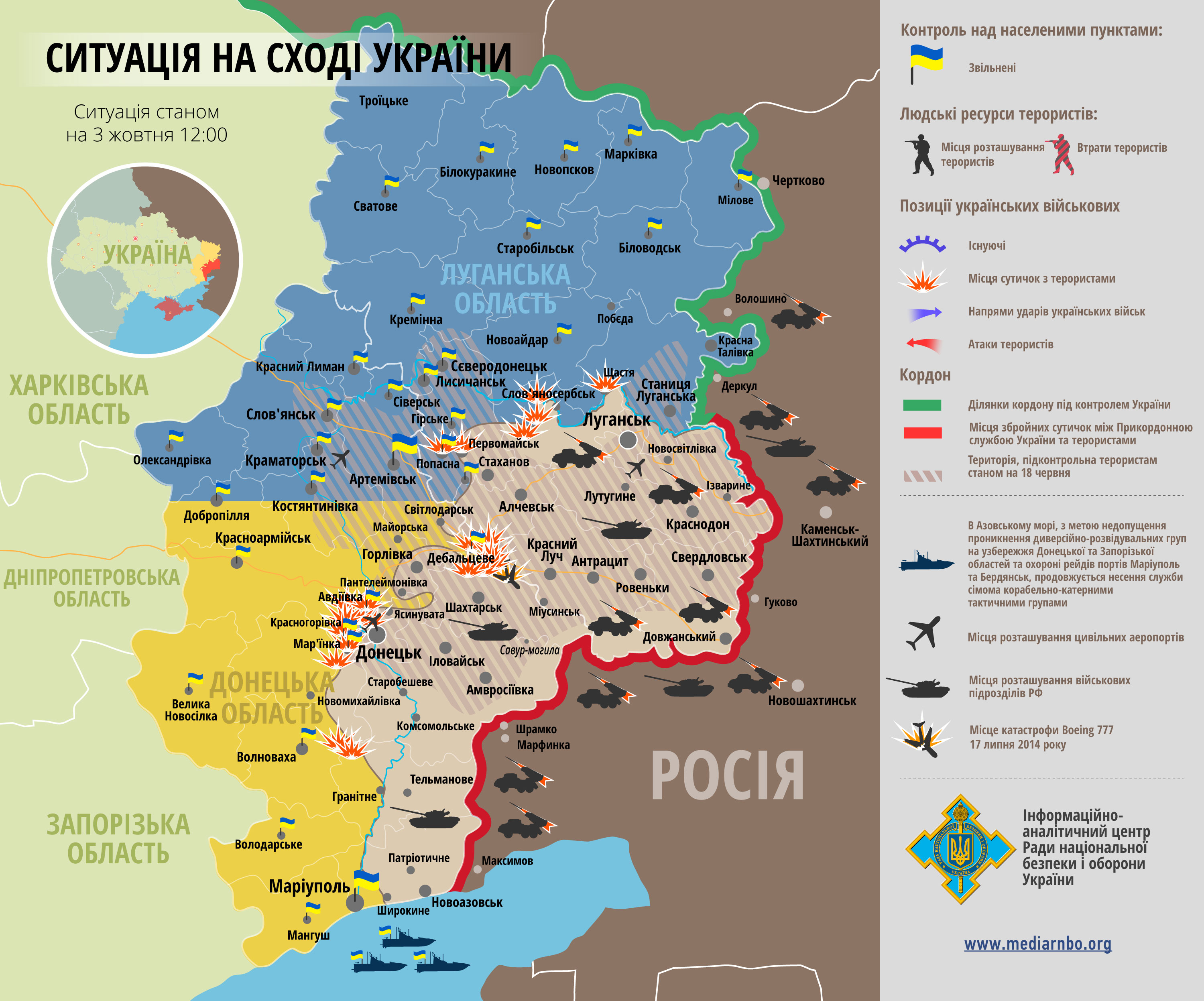
Sources for the changes on 3 September 2014 - 23:03 UTC (4 September 2014 00:03 London/Lisbon time)[edit]
- http://interfax.com.ua/news/general/226097.html
- http://www.pravda.com.ua/rus/news/2014/09/30/7039420/
- http://www.osce.org/ukraine-smm/124979
- http://112.ua/obshchestvo/karta-ato-po-sostoyaniyu-na-1-oktyabrya-122978.html
- http://www.pravda.com.ua/news/2014/09/27/7039110/
Mondolkiri1 (talk) 23:08, 4 October 2014 (UTC)
Sources for the changes on the File:East_Ukraine_conflict.svg on 6 October 2014 - 22:03 UTC[edit]
- http://militarymaps.info/
- http://news.liga.net/news/politics/3529989-za_sutki_pogibli_2_ukrainskikh_voennykh_terroristy_narashchivayut_sily.htm
- http://www.pravda.com.ua/news/2014/10/5/7039834/
- http://www.ukrinform.ua/ukr/news/boyoviki_pid_mariupolem_postiyno_gatyat_z_tankiv___hochut_vraziti_misiyu_obse__video_1978430
- http://www.unian.ua/society/992527-pri-obstrili-schastya-poraneno-9-mirnih-jiteliv-i-odin-viyskoviy.html
- http://www.unian.ua/politics/992539-rnbo-obstrili-z-ustanovok-grad-zafiksovani-v-rayoni-lisichanska-mapa-ato.html
- http://www.unian.net/politics/992438-segodnya-v-donetske-iz-za-obstrela-boevikov-pogibli-dva-cheloveka.html#ad-image-0
- http://www.pravda.com.ua/news/2014/10/5/7039830/
Mondolkiri1 (talk) 22:19, 6 October 2014 (UTC)
Sources for the changes on the File:East_Ukraine_conflict.svg on 8 October 2014 - 23:49 UTC[edit]
- http://militarymaps.info/
- http://www.pravda.com.ua/news/2014/10/5/7039830/
- http://www.pravda.com.ua/news/2014/10/5/7039834/
- http://fakty.ua/189020-boeviki-snova-obstrelyali-doneck-ubity-3-mirnyh-zhitelya
- http://news.liga.net/news/politics/3568081-terroristy_obstrelyali_zolotoe_luganskoy_oblasti_pogibla_zhenshchina.htm
- http://ru.tsn.ua/ukrayina/boeviki-rushat-schaste-atakuyut-debalcevo-i-ryschut-pod-mariupolem-karta-ato-390425.html
- http://www.pravda.com.ua/rus/news/2014/10/8/7040097/
- http://www.segodnya.ua/regions/donetsk/gorlovka-pod-obstrelom-skorye-otkazyvayutsya-ehat-k-ranenym-558593.html
Where there has been fighting from 5 October on, and where the control is divided, contested (or ambiguous) it's orange. Mondolkiri1 (talk) 00:03, 9 October 2014 (UTC)
A barnstar for you![edit]
|
|
The Graphic Designer's Barnstar |
| The reward for the excellent work. Regards! Hanibal911 (talk) 05:21, 9 October 2014 (UTC) |
Serbian borders[edit]
Don't touch the Eurovision maps & the Kosovo borders. Kosovo has participated in Eurovision Young Dancers 2011 as a country, which means that EBU doesn't recognize it as part of Serbia.
108 countries recognize Kosovo, USA, UK, Scandinavia, Western Europe and 90% of European Union. Your reason "international borders of Serbia" is not valid.
- Stop edit warring over the map, Kosovo is included due to the fact it has participated in the Young Musicians contest and recognised by many countries in Europe. Northern Cyprus has not participated in anything, and is only recognised by Turkey. Also we have to have limits on what unrecognised territories we include. Instead express your arguments on the Files talk page. --AxG (talk) 20:32, 19 November 2014 (UTC)
Thanks too[edit]
You're welcome, and thanks a lot too for went further on applying the same shade of pale green on all ASEAN countries maps..! I'm about to do it, but you beat me to it. Anyway, glad you love Cambodia, it is indeed a wonderful kingdom. Just visited Siem Ream few years ago. If you love Angkor temples like I do, I suggest you to visit Indonesian Yogyakarta someday, seeing Borobudur, Prambanan and many other Indonesian temples, cheers.Gunkarta (talk) 15:58, 19 November 2014 (UTC)
Nordic council on European maps[edit]
Stop adding the Nordic Council to European maps without reaching a consensus first! If you want to start a discussion about possibly adding the Nordic Council to European maps then you are free to do so, however it definitely cannot be done in the way you did it as Denmark, Sweden and Finland are also in the EU and depicting them in only blue implies that they're not and can be confusing. If you continue your disruptive edits you will be reported! --Leftcry (talk) 19:30, 19 November 2014 (UTC)
- Leftcry OK, I'm not very concerned, I'm not Nordic and I won't change anything about Denmark, Sweden, Finland, Norway, Iceland, the Faroe Islands and Greenland (though I've lived in DK, so I know what I'm talking about). But if it was about an Iberian issue you'd bet I'd confront you (in a rethoric manner) about that issue. As it is concerning to those guys in the North, who cares? I've already (along with an Indonesian new friend) updated all the maps concerning to ASEAN, why did I care about the Nordics? Mondolkiri1 (talk) 23:05, 19 November 2014 (UTC)
File:Philippines ASEAN.PNG[edit]
How did you make a globe highlighting the ASEAN region, especially the Philippines?
By the way, I'm making a fictional Infobox on my own Sandbox, and I know it's quite embarrassing, but can you make another version of your file "Philippines ASEAN.PNG", this time, Sabah is the same shade of green as the rest of the Philippines.
Don't worry, it's just a piece of fiction.
Thanks!
Situation in East Ukraine on 21 November[edit]
Hi, I see you're back and here a data for update the map. Ukrainian government public the list of cities which controlled by DNR and LPR rebels. in the Donetsk region, Donetsk, Dokuchaevsk, Horlivka, Yenakiieve (except suburbs - Uglegorsk) Zhdanivka, Kirovsk, Makiivka, Snizhne, Torez, Khartsyzk, Shakhtars'k and Zuhres, Yasinovataya. Also under control the rebels (DNR) all settlements in Amvrosiivka Raion, Starobesheve Raion, Shakhtarsk Raion , and villages Pionerske, Prymorske, Kominternove, Vodiane, Zaichenko, Shyrokyne, Berdianske, Pavlopil, Pishevik, Chernenko, and Lebedinskoye, Sopyne in Novoazovskiy district. In Lugansk region in this list the city of Luhansk, Alchevsk, Anthracite, Bryanka, Kirovsk, Krasnyi Luch, Krasnodon, Pervomais'k, Rovenki, Sverdlovsk and Stakhanov, and all settlements in Antratsyt Raion, Krasnodon Raion, Lutuhyne Raion, Perevalsk Raion Sverdlovsk Raion and Slovianoserbsk Raion Korrespondent UADaily UATelegraf.by Hanibal911 (talk) 08:41, 24 November 2014 (UTC)
- Hanibal911Well, for a number of reasons, including expressing my personal opinions about the War in Donbass, I've been, so far, blocked, from editing in the actual articles on English Wikipedia, and the map on English Wikipedia has been replaced by a less detailed map (namely considering Horlivka, or Gorlovka, whatever you prefer, as a kind of disputed city). But I'll take into account your suggestions, since I haven't been blocked on Wikimedia Commons. Mondolkiri1 (Mondolkiri1) 22:07, 24 November 2014 (UTC)
- Sorry but your informations are outdated now.Mondolkiri1 (Mondolkiri1) 22:32, 24 November 2014 (UTC)
Iraqi Insurgency map[edit]
mind if you update the map? It is outdated and no one else has done it so far.--Arbutus the tree (talk) 03:01, 26 November 2014 (UTC) Arbutus the tree
- The only thing I updated in this map, so far, was concerning to the very narrow strip between Israel and Syria, in the Golan Heights, since it included a territory that was included in the partition between Israel and Palestine, therefore, I though at the time that though Syria may have claims concerning to that very narrow strip, it would be, at most, be a matter between Israel and Palestine, not between Israel and Syria. Anyway, because of some personal considerations I've made about the form in which the situation in Ukraine was being approached, I'm blocked from editing in the English Wikipedia (though not in the Wikimedia Commons). But I'v seen maps about the ISIS control that differ a lot from this one in Wikipedia (since here, there are a lot of desert lands that are assumed to be under ISIS control, when they're actually desert, I think that more appropriately they should be (maybe) white... not under any control.Mondolkiri1 (Mondolkiri1) 01:05, 29 November 2014 (UTC)
Maps of South America[edit]
Hello, Mondolkiri1, I propose you add the member states of UNASUR in light green on the maps (of Brazil, Argentina, etc.) as UNASUR is more advanced than ASEAN yet, member states of ASEAN have the members of the union in light green on their map (see Thailand). The African Union, also has member states in light green (see South Africa). Of course the EU does the same thing as well.
I think that it's very important to make this change because by the end of 2015, UNASUR will takes step towards creating South American citizenship and freedom of movement (see here), thus being more similar to the European Union.
Hope you consider this change,-Viladive (talk) 17:34, 31 December 2014 (UTC)
- Hi Mondolkiri1! Thank for responding to my request, I see you have asked others to do it because you have problems with .svg files. Well thanks anyways for asking other users.-Viladive (talk) 21:55, 4 January 2015 (UTC)
- @Viladive: You're welcome! Usually I don't have problems with svg files, but this time I had because they are orthographic projections. I discussed this issue with Spesh531 and apparently he is going to fix these files. If you have suggestions, you may discuss it in the talk page of this user.Mondolkiri1 (talk) 23:13, 4 January 2015 (UTC)
- Yeah, the user right here! —SPESH531Other 00:03, 5 January 2015 (UTC)
- @Viladive: You're welcome! Usually I don't have problems with svg files, but this time I had because they are orthographic projections. I discussed this issue with Spesh531 and apparently he is going to fix these files. If you have suggestions, you may discuss it in the talk page of this user.Mondolkiri1 (talk) 23:13, 4 January 2015 (UTC)
Please do not overwrite files[edit]
Denniss (talk) 06:55, 6 January 2015 (UTC)
- If you continue to ignore this warning you'll be blocked. Controversial "updates" have to uploaded under a new name. Do not force other Wikis to use your "improved" file. --Denniss (talk) 08:41, 6 January 2015 (UTC)
- Eso está siendo discutido ahora en mi página de discusión, en portugués! Lo que hice fue por un pedido de un otro usuario. Pero, ahora no hago intenciones de proseguir más, hasta que esta questión sobre los países de UNASUR / UNASUL sea resolvida. Mondolkiri1 (talk) 08:50, 6 January 2015 (UTC)
- Mondolkiri, your maps should show the same area shown on the globe on the maps you replace with transparent boundaries around it. Also for color coding I suggest the normal green (color id: #218439 ) for the country, lime green (color id: #76c712 ) for claimed territories, and light green (color id: #c6debd ) for UNASUR. If you can't do that we should probably wait for Spesh531's to upload-Viladive (talk) 17:03, 6 January 2015 (UTC)
- @Viladive: I'd suggest you'd discuss this issue with Spesh531 to whom I asked the change in the maps and he or she agreed. @Spesh531: is more experienced with maps than I am and I'm not being able to do it with a higher quality. I'd also suggest you'd discuss it with the 2 users that contested my changes. Mondolkiri1 (talk) 08:50, 6 January 2015 (UTC)
- @Spesh531: Thank you a lot for those files! I'll discuss that issue in the articles of UNASUR/UNASUL on Portuguese and Spanish wikipedias, as well as with the users that contested the modification of the existing files, though in one of the 2 cases it might just be a matter of quality. And I'll try to discuss that as well with other South American users. @Viladive: you're also invited in these discussions, of course.Mondolkiri1 (talk) 15:19, 7 January 2015 (UTC)
- @Viladive: I'd suggest you'd discuss this issue with Spesh531 to whom I asked the change in the maps and he or she agreed. @Spesh531: is more experienced with maps than I am and I'm not being able to do it with a higher quality. I'd also suggest you'd discuss it with the 2 users that contested my changes. Mondolkiri1 (talk) 08:50, 6 January 2015 (UTC)
- Mondolkiri, your maps should show the same area shown on the globe on the maps you replace with transparent boundaries around it. Also for color coding I suggest the normal green (color id: #218439 ) for the country, lime green (color id: #76c712 ) for claimed territories, and light green (color id: #c6debd ) for UNASUR. If you can't do that we should probably wait for Spesh531's to upload-Viladive (talk) 17:03, 6 January 2015 (UTC)
- Eso está siendo discutido ahora en mi página de discusión, en portugués! Lo que hice fue por un pedido de un otro usuario. Pero, ahora no hago intenciones de proseguir más, hasta que esta questión sobre los países de UNASUR / UNASUL sea resolvida. Mondolkiri1 (talk) 08:50, 6 January 2015 (UTC)
Countries belonging to UNASUR / UNASUL[edit]
Could you point me to the file(s) that you're discussing? I can't remember modifying any files like this; I don't think I've even heard of UNASUR or UNASUL before. Nyttend (talk) 14:06, 7 January 2015 (UTC)
- @Nyttend: The files are in the talk page of Spesh531. Concerning to not having heard of UNASUR or UNASUL before doesn't mean that it doesn't exist. Mondolkiri1 (talk) 15:25, 7 January 2015 (UTC)
- Are you talking about ones such as File:UNASUL-Brazil.svg? I don't have an SVG editor program, so I don't see how I can resolve the issue for you. I never suggested that UNASUR and UNASUL don't exist; I simply meant that I was unaware of their existence, thus implying I had no clue what maps you were asking about, let alone why you asked me in particular. Nyttend (talk) 15:50, 7 January 2015 (UTC)
- @Nyttend: Oh, OK, so I made a confusion, because there have been some discussions about these files, and I thought you had been involved in one of those discussions. Sorry for the confusion. And yes, those are the files.Mondolkiri1 (talk) 15:54, 7 January 2015 (UTC)
- I understand; I would have been able to give you a more sensible answer if I'd not also been confused. I'm even surprised that these are subjects of a discussion; basic maps of countries without major territorial disputes don't normally get discussed in my experience. Nyttend (talk) 02:38, 8 January 2015 (UTC)
- @Nyttend: Oh, OK, so I made a confusion, because there have been some discussions about these files, and I thought you had been involved in one of those discussions. Sorry for the confusion. And yes, those are the files.Mondolkiri1 (talk) 15:54, 7 January 2015 (UTC)
- Are you talking about ones such as File:UNASUL-Brazil.svg? I don't have an SVG editor program, so I don't see how I can resolve the issue for you. I never suggested that UNASUR and UNASUL don't exist; I simply meant that I was unaware of their existence, thus implying I had no clue what maps you were asking about, let alone why you asked me in particular. Nyttend (talk) 15:50, 7 January 2015 (UTC)
donbas war map[edit]
Hello. I am messaging you and a couple others. Maybe this [2] should be updated? (Lilic (talk) 16:35, 20 January 2015 (UTC)).
![[2]](https://commons.wikimedia.org/wiki/File:East_Ukraine_conflict.svg)
|
|
File:Active separatist movements in Europe.png has been listed at Commons:Deletion requests so that the community can discuss whether it should be kept or not. We would appreciate it if you could go to voice your opinion about this at its entry.
If you created this file, please note that the fact that it has been proposed for deletion does not necessarily mean that we do not value your kind contribution. It simply means that one person believes that there is some specific problem with it, such as a copyright issue. Please see Commons:But it's my own work! for a guide on how to address these issues. |
Wuselig (talk) 08:49, 9 February 2015 (UTC)
|
|
File:Eurasian Economic Union - RU-KZ-AM-BY.JPG has been listed at Commons:Deletion requests so that the community can discuss whether it should be kept or not. We would appreciate it if you could go to voice your opinion about this at its entry.
If you created this file, please note that the fact that it has been proposed for deletion does not necessarily mean that we do not value your kind contribution. It simply means that one person believes that there is some specific problem with it, such as a copyright issue. Please see Commons:But it's my own work! for a guide on how to address these issues. |
A.Savin 19:52, 21 February 2015 (UTC)
|
|
File:Eurasian Economic Union RU-KZ-AM-BY.JPG has been listed at Commons:Deletion requests so that the community can discuss whether it should be kept or not. We would appreciate it if you could go to voice your opinion about this at its entry.
If you created this file, please note that the fact that it has been proposed for deletion does not necessarily mean that we do not value your kind contribution. It simply means that one person believes that there is some specific problem with it, such as a copyright issue. Please see Commons:But it's my own work! for a guide on how to address these issues. |
A.Savin 19:53, 21 February 2015 (UTC)
|
|
File:Museo de la Gran Guerra Patriotica, Moscú.JPG has been listed at Commons:Deletion requests so that the community can discuss whether it should be kept or not. We would appreciate it if you could go to voice your opinion about this at its entry.
If you created this file, please note that the fact that it has been proposed for deletion does not necessarily mean that we do not value your kind contribution. It simply means that one person believes that there is some specific problem with it, such as a copyright issue. Please see Commons:But it's my own work! for a guide on how to address these issues. |
A.Savin 19:54, 21 February 2015 (UTC)
File source is not properly indicated: File:Zenkov cathedral and Central Mosque Almaty.JPG[edit]
| This media was probably deleted. |
A file that you have uploaded to Wikimedia Commons, File:Zenkov cathedral and Central Mosque Almaty.JPG, was missing information about where it comes from or who created it, which is needed to verify its copyright status. The file probably has been deleted. If you've got all required information, request undeletion providing this information and the link to the concerned file (
[[:File:Zenkov cathedral and Central Mosque Almaty.JPG]]).
If you created the content yourself, enter If someone else created the content, or if it is based on someone else's work, the source should be the address to the web page where you found it, the name and ISBN of the book you scanned it from, or similar. You should also name the author, provide verifiable information to show that the content is in the public domain or has been published under a free license by its author, and add an appropriate template identifying the public domain or licensing status, if you have not already done so. Warning: Wikimedia Commons takes copyright violations very seriously and persistent violators will be blocked from editing. Please add the required information for this and other files you have uploaded before adding more files. If you need assistance, please ask at the help desk. Thank you! |
Denniss (talk) 19:58, 21 February 2015 (UTC)
- Denniss I think I provided now the required informations. Can you check them, please? Mondolkiri1 (talk) 16:28, 23 February 2015 (UTC)
|
|
File:Active separatist movements in Europe.png has been listed at Commons:Deletion requests so that the community can discuss whether it should be kept or not. We would appreciate it if you could go to voice your opinion about this at its entry.
If you created this file, please note that the fact that it has been proposed for deletion does not necessarily mean that we do not value your kind contribution. It simply means that one person believes that there is some specific problem with it, such as a copyright issue. Please see Commons:But it's my own work! for a guide on how to address these issues. |
Rob984 (talk) 10:04, 11 June 2016 (UTC)
|
|
File:Unión Euroasiática-2015.svg has been listed at Commons:Deletion requests so that the community can discuss whether it should be kept or not. We would appreciate it if you could go to voice your opinion about this at its entry.
If you created this file, please note that the fact that it has been proposed for deletion does not necessarily mean that we do not value your kind contribution. It simply means that one person believes that there is some specific problem with it, such as a copyright issue. Please see Commons:But it's my own work! for a guide on how to address these issues. |
153.2.246.38 14:50, 28 August 2018 (UTC)
Notification about possible deletion[edit]
|
|
Some contents have been listed at Commons:Deletion requests so that the community can discuss whether they should be kept or not. We would appreciate it if you could go to voice your opinion about this at their entry.
If you created these pages, please note that the fact that they have been proposed for deletion does not necessarily mean that we do not value your kind contribution. It simply means that one person believes that there is some specific problem with them, such as a copyright issue. Please see Commons:But it's my own work! for a guide on how to address these issues. |
Affected:
Yours sincerely, A1Cafel (talk) 04:17, 4 February 2021 (UTC)
.PNG)
|
|
File:Federal States of New Russia in Ukraine (Envisaged).PNG has been listed at Commons:Deletion requests so that the community can discuss whether it should be kept or not. We would appreciate it if you could go to voice your opinion about this at its entry.
If you created this file, please note that the fact that it has been proposed for deletion does not necessarily mean that we do not value your kind contribution. It simply means that one person believes that there is some specific problem with it, such as a copyright issue. Please see Commons:But it's my own work! for a guide on how to address these issues. |
.PNG)
.PNG)