Cmglee - I am fascinated by the analysis you did visualizing location of sunrise and sunset at Manhattanhenge. I am trying to establish how close Greenwich Village/Meatpacking District's Gansevoort Street is aligned to the equinox. Have just discovered it is an old Native American trail and having lived in the area 15 years have always noticed the equinox sunsets each Spring and Fall. More detail here at Bolton's 1922 map but if you have any advice, I would appreciate it. I was a little confounded by the Earth System Research Laboratory website you linked to! Info use here w:Jackson Square ParkWindingRoad (talk) 16:09, 29 March 2015 (UTC)WindingRoad[reply]
Thanks, WindingRoad. That's an interesting question! I took a screenshot of the area on Google Maps and pasted it in an image editor. I found that rotating it clockwise by 1 degree made Gansevoort St horizontal, so it would be most closely aligned on Mar 22, 2015 (solar declination = 0.84°) according to http://www.esrl.noaa.gov/gmd/grad/solcalc . Even better, the next street, Horatio St is almost exactly east-west, so it should exactly align during the equinox — though the trees may spoil the view! cmglee (talk) 19:41, 30 March 2015 (UTC)[reply]
Cmglee - thanks for doing that analysis, very helpful, very interesting. I just posted some pics I took before (believe it or not) i fully realized this was so close to the equinox! Unfortunately they are off by a few days, but I think you'll find them interesting, too!

 032215 Horatio Street 19-04 hours
 032315 Horatio Street 19-00 hours
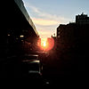 032315 Gansevoort Street 18-59 hours
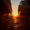 032415 Gansevoort Street 19-01 hours


