Commons:Graphic Lab/Map workshop/Archive/2015
 | This is an archive of past discussions. Do not edit the contents of this page. If you wish to start a new discussion or revive an old one, please do so on the current talk page. |
Map Burgundian Kingdom 2 EN.png into SVG
-
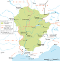 Map Burgundian Kingdom

- Article(s)
- es:Imperio romano de Occidente,es:Reinos de los burgundios,es:Reino de Borgoña,es:Reino de los francos en la época merovingia
- Request
- I would like to request a SVG version of the above map as I would like to translate it into Spanish and use it as a base for other maps that are also in PNG format and that could also be quickly turned into SVG once the basis is available. Thank you in advance.--Rowanwindwhistler (talk) 10:57, 11 February 2015 (UTC)
- Graphist opinion(s)
![]() Request taken by Goran tek-en (talk) 18:51, 22 February 2015 (UTC)
Request taken by Goran tek-en (talk) 18:51, 22 February 2015 (UTC)
@Rowanwindwhistler: Now there is a draft to look at. Give me feedback, thanks. --Goran tek-en (talk) 19:17, 25 February 2015 (UTC)
- It looks great! Thank you!!--Rowanwindwhistler (talk) 20:02, 25 February 2015 (UTC)
- @Rowanwindwhistler: Now you can find it here Map Burgundian Kingdom. --Goran tek-en (talk) 19:11, 1 March 2015 (UTC)
- Thank you!--Rowanwindwhistler (talk) 09:00, 2 March 2015 (UTC)
- @Rowanwindwhistler: Now you can find it here Map Burgundian Kingdom. --Goran tek-en (talk) 19:11, 1 March 2015 (UTC)
![]() Done:This section was archived on a request by: Goran tek-en (talk) 19:11, 1 March 2015 (UTC)
Done:This section was archived on a request by: Goran tek-en (talk) 19:11, 1 March 2015 (UTC)
Vectorize map of WWII Germany
-
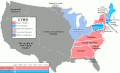
 PNG map of German-dominated Europe, 1941/42

- Article(s)
- Large number of articles. The file is used on most Wikis.
- Request
- Perhaps a bit of challenge(?), but I thought I'd post it if someone out there feels like they might to give it a shot. The need for this image is present everywhere, but we're still using a pretty low-res PNG image, and I think we've refined the file's factual content to the point that its ready for an upgrade to SVG. If anyone's up for it, your file will be up on quite a lot of high-traffic articles, and I'm sure you'll have the gratitude of WWII-buff editors everywhere. --DIREKTOR (TALK) 23:00, 21 January 2015 (UTC)
- P.s. There's no need imo to follow exactly the style of the PNG map, as in the fonts or the light blue used for sea areas. Recommend using File:Europe_1942.svg as a starting point. --DIREKTOR (TALK) 00:13, 22 January 2015 (UTC)
- Graphist opinion(s)
![]() Request taken by Goran tek-en (talk) 18:44, 22 February 2015 (UTC)
Request taken by Goran tek-en (talk) 18:44, 22 February 2015 (UTC)
- @DIREKTOR: Now there is a draft to look at and give me feedback. Anything goes, you are the one who knows what you want, thanks. --Goran tek-en (talk) 18:54, 1 March 2015 (UTC)
- Seems great. The winter offensive area could be in stripes, I guess. And the Soviets and Western Allies could be in different colour schemes per the original image. The white outline of the text seems a bit over-contrasting with the black background in places. I don't think we need a frame... That's all I've got. --DIREKTOR (TALK) 09:49, 2 March 2015 (UTC)
- @DIREKTOR: You wrote "There's no need imo to follow exactly the style of the PNG map" so I don't really understand some remarks, but I do as you like it to be (for the most).
- What is the difference if the winter area is striped or solid colored?
- The allied were one entity so why different colors?
- To me the frame holds the map together and gives it a clear ending. If you not really bad wont it to be removed I would like to keep it. To me it's graphically better.
- The white outline is for the texts that cross black lines, to dark background etc. I have made them softer.
- New draft to look at and give me feedback, thanks. --Goran tek-en (talk) 16:41, 3 March 2015 (UTC)
- @DIREKTOR: You wrote "There's no need imo to follow exactly the style of the PNG map" so I don't really understand some remarks, but I do as you like it to be (for the most).
- @Goran tek-en: (sorry, was absent for a while.)
- No difference, really. I just like the striped style.
- That's how the map was for the past several years. I don't think its a bad idea. In many ways the USSR and the Western Allies were separate combat entities.
- I don't think we need a frame as it'll just be double-framed in any thumbnail and/or infobox.
- Could you make the text white over darker areas? D'you think that's a good idea?
- --DIREKTOR (TALK) 16:24, 16 March 2015 (UTC)
- @Goran tek-en: (sorry, was absent for a while.)
I will of course remove the frame.
About white text on the darker areas ..... I don't know. I'm not fond of it. I have to see so I will get back to you. --Goran tek-en (talk) 19:02, 16 March 2015 (UTC)
- @DIREKTOR: New draft to look at and give me feedback on. I did the text light, not white. --Goran tek-en (talk) 19:20, 16 March 2015 (UTC)
- @Goran tek-en: Is it possible to have the sea in white, country borders in white, neutral countries in grey (as in here), Axis in shades of blue (blue as in here), the Soviet Union in red, and Western-Allied regions in green? --DIREKTOR (TALK) 12:44, 17 March 2015 (UTC)
- @DIREKTOR: Look at this draft here. Why there are small dark areas on some borders I don't know because they are all white. At this render link you can see how it looks like when I test it on a rendering tool we have. This is doing exactly what any Wikimedia site will do. When you look at my drafts that is in another place which renders it differently. I haven't done the legend or text yet. I want you to see if I got it right and that is what you want, give me feedback, thanks. --Goran tek-en (talk) 19:45, 17 March 2015 (UTC)
- @Goran tek-en: . Yeah, I always open them in Inkscape, they're white to me as well and I think that's how they'll appear once uploaded. I can think of no nitpicks besides asking for a more subdued shade of green, perhaps slightly closer to the PNG image. The inland waters appear to be blue rather than white... Otherwise, very nice work indeed. --DIREKTOR (TALK) 23:16, 17 March 2015 (UTC)
- P.s, could the striped area be red/blue, rather than red/white? With the stripes at an angle, rather than vertical? --DIREKTOR (TALK) 00:08, 18 March 2015 (UTC)
- @Goran tek-en: P.p.s it would probably be useful to upload two versions: one with labels and legend, one like that, without both. --DIREKTOR (TALK) 09:53, 18 March 2015 (UTC)
- P.s, could the striped area be red/blue, rather than red/white? With the stripes at an angle, rather than vertical? --DIREKTOR (TALK) 00:08, 18 March 2015 (UTC)
- @Goran tek-en: . Yeah, I always open them in Inkscape, they're white to me as well and I think that's how they'll appear once uploaded. I can think of no nitpicks besides asking for a more subdued shade of green, perhaps slightly closer to the PNG image. The inland waters appear to be blue rather than white... Otherwise, very nice work indeed. --DIREKTOR (TALK) 23:16, 17 March 2015 (UTC)
- @DIREKTOR: Look at this draft here. Why there are small dark areas on some borders I don't know because they are all white. At this render link you can see how it looks like when I test it on a rendering tool we have. This is doing exactly what any Wikimedia site will do. When you look at my drafts that is in another place which renders it differently. I haven't done the legend or text yet. I want you to see if I got it right and that is what you want, give me feedback, thanks. --Goran tek-en (talk) 19:45, 17 March 2015 (UTC)
- @Goran tek-en: Is it possible to have the sea in white, country borders in white, neutral countries in grey (as in here), Axis in shades of blue (blue as in here), the Soviet Union in red, and Western-Allied regions in green? --DIREKTOR (TALK) 12:44, 17 March 2015 (UTC)
@DIREKTOR: Look at this draft here.
- You wrote: "subdued shade of green, perhaps" but I guess you meant, blue? Anyway I haven't changed them yet as I think it would be even harder for people with color problems to view it correct. It's already hard but would be even harder if the blue shades got any closer. If you still want this really really bad tell me.
- If we are getting close to upload I will need the following for both versions;
- Name of the file
- Description
- Category/ies at commons
to be able to upload them at commons. Give me feedback, thanks. --Goran tek-en (talk) 18:55, 19 March 2015 (UTC)
- @Goran tek-en: That's it, its done I think :).
- I meant green, the colour used for Western Allied-held territory (in this case UK-held, basically). Never mind that, though, we're good.
- "World War II in Europe, 1942" and "World War II in Europe, 1942 (no labels)"
- "Europe at the height of Axis success"?
- The cats you can copy-paste from here.
- Once its uploaded I'll global-replace the old PNG file with the new version.
- I posted a request down below for a blank map of Europe at the outbreak of WWII, I think it can be helpful for a number of articles. If I'm not pushing too hard, I wonder if you could take a look? It oughtn't be a lot of effort? --DIREKTOR (TALK) 19:18, 19 March 2015 (UTC)
- @Goran tek-en: That's it, its done I think :).
Now you can find them here;
- World War II in Europe, 1942
- World War II in Europe, 1942 (no labels)
- Right now I have to much going on, but if it's still not taken by someone else in a month time you can contact me again. --Goran tek-en (talk) 09:56, 20 March 2015 (UTC)
![]() Done:This section was archived on a request by: Goran tek-en (talk) 09:56, 20 March 2015 (UTC)
Done:This section was archived on a request by: Goran tek-en (talk) 09:56, 20 March 2015 (UTC)
PNG to SVG
-
 Map of Brazil

- Article(s)
- it:voy:Brasile_del_nordest
- Request
- I'd like to have the first image in svg format, so that I can translate it easily for it.voy or other voy. The second map could be a good base, since it is already an svg --Nastoshka (talk) 19:13, 14 February 2015 (UTC)
- Graphist opinion(s)
@Nastoshka: ![]() Request taken by Goran tek-en (talk) 12:00, 27 March 2015 (UTC)
Request taken by Goran tek-en (talk) 12:00, 27 March 2015 (UTC)
- @Nastoshka: I have started to work on your requested svg map and I need your input to be able to continue. What I'm thinking about is how to make the map as legible as possible and what you need the map to show for your purpose.
- Is the coloring of the different areas (Bahia, etc) important or is naming them enough?
- Do you want the roads in the map, about the same as the one you have now?
- Do you want rivers, lakes in the map?
- Should we try to keep as much text (names) as possible outside the map and in a "legend" on the article page?
- Any other ideas and information you want to share with me. --Goran tek-en (talk) 08:40, 31 March 2015 (UTC)
- Hej @Goran tek-en: and thanks for taking care of my request. The answer to your questions are the following:
- Yes, the colours are important and on wikivoyage we use standard ones. You can find them here. The colours are used in a template that works as a key for regions and colours (so on the contrary, naming is not so important). See an example on this page.
- Roads and railways are optional. Usually we add them only if the result is clear and legible enough.
- Yes please, lakes and rivers are important in a travel map. If it is possible add also their name with the standard font and colours that you can find on the same palette.
- It is preferable that all the text in the [[:|current map]] is kept.
Tack så mycket en gång till :) --Nastoshka (talk) 22:25, 31 March 2015 (UTC)
- @Nastoshka: Thanks for that info, it's really important for I started to use the other template we use for maps. So next time you request a travel map for wikivoyage it's very important that you mention what template to use and why. If that is not mentioned we have no way to no that and then we will spend hours in vain.
- I looked at your profile and whoooooh, how can you know that many languages, I'm impressed. --Goran tek-en (talk) 12:14, 1 April 2015 (UTC)
- @Nastoshka: I now looked at the template and there are two issues with the chosen fonts;
- The words, Airport And Train Station uses Blue Highway which to this page svg fonts is not an approved font.
- The rest of the text uses DejaVu Sans Condensed. I run Ubuntu 14.04 and that font has another name with me, DejaVu Sans Semi-Condensed. What that will mean when the file is rendered at Wikimedia I can't say for sure. I will try to keep the original name but it can give some problems regarding that I don't really know how the text will flow and spread out.
- If you have anything to do with that template or you know who does, it would be good to inform them about this. I would go for a font which is not included in "extra packages" or special in any other way. --Goran tek-en (talk) 12:44, 1 April 2015 (UTC)
- @Nastoshka: I now looked at the template and there are two issues with the chosen fonts;
- @Nastoshka: Thanks for that info, it's really important for I started to use the other template we use for maps. So next time you request a travel map for wikivoyage it's very important that you mention what template to use and why. If that is not mentioned we have no way to no that and then we will spend hours in vain.
@Nastoshka: Now you have drafts to look at. I show you three different and you will have to tell me which you want or something else.
I have some names in a legend, and as you use colors for the different areas I have also excluded the names from the map. To me this makes the map more legible. But you are the user of the map so it's up to you for most.
- all, haven't put in road numbers yet.
- roads, haven't put in road numbers yet.
- rivers. Get back to me with feedback, thanks. --Goran tek-en (talk) 19:00, 1 April 2015 (UTC)
Hi @Goran tek-en: , you've crafted a very nice map. Thanks a lot! Perhaps the only thing missing is the label "Atlantic Ocean" for the ocean. Regarding the fonts used in the map, they were decided by en:voy long time ago, before I started to contribute to wikivoyage so I don't know much about them. However we're planning to review many maps and try to have some homogeneity among the different linguistic versions of wikivoyage. I'll talk about this problem with fonts. FYI I use Linux Mint and I have some problems with that font too. At moment you can use the ones you chose, since they are very similar to the standard fonts. Just one question: Could you add all texts (included "Northeast Brazil", the compass, and the key for kilometers) in a separate layer called "Labels"? When you'll have uploaded the map, I will need to modify it with Inkscape in order to create some sublayers to "Labels", one for the German translation, one for the Italian, one for the Swedish etc.. (Actually I'm a translator in real life and this is also one of my task on voys projects). Tell me if this is a problem. Thanks again! --Nastoshka (talk) 08:03, 2 April 2015 (UTC)
- @Nastoshka:
 Question You didn't tell me which version of the three alternatives you wanted?
- Question Do you want me to add the road numbers if you want the roads in the map?
 Comment When you redo the template please consider the other map templates that are used at Commons (and other places) and try to make the template so it also work for people with color blindness, it can be very hard sometimes. If I or any one else here at Commons can assist you with that just give us a notice.
- As far as possible we try to upload svg files as plain-svg and not as an Inkscape-svg. Inkscape adds a lot of specific program information into the file which is not important, and all other vector programs do the same. A lot of people also edit svg files with text editor and then it's easier without all the program specific code.
- In Inkscape when you use File/Save As or File/Save a Copy down in the right hand corner you choose how to save it. There is one choice, Plain SVG (*.svg). That one gives you as pure svg file you can get from the program, without editing the code manually. Before you save it it's always good to do File/Vaccum Defs which removes a lot of stuff which you are not using in the final version but have done during your work.
- When you open a plain-svg file (you really don't know it is) you will find that it consists of different groups. Each layer in the original Inkscape file has become one group. So in my file, if you click on the legend you will get everything I had in that layer. The same with cities names, area names and so on. That makes it not so hard for you to do your work even when I upload it as plain-svg. I keep the original Inkscape file with me if any further work needs to be done but I always try to upload it as plain-svg. Sometimes I upload it as an Inkscape but that is very seldom and for a very good reason, extremely complex or other significant reason.
- I don't know if you upload the different languages versions as separate files or as one and if you need the layer (Inkscape) information to make it work. Depending on that you should also upload them at Commons as plain-svg. I know that there is one way to work with different languages in one svg file. You add all and then you call on the language you need for a particular page, check here. The whole page is about translations in a svg-file. It just stroke me that you are a translator so probably you know much more then I about this. I'm sorry if I told you a lot you already know, that was not my purpose and if so, I'm sorry.
- So get back to me on which version you want, thanks. --Goran tek-en (talk) 10:16, 2 April 2015 (UTC)
@Goran tek-en: ,
Thanks a lot for all info you gave me. Yes, I knew almost all but it was kind of you. I did not know, for instance, about File/vacuum def. I'll do it when I upload a file created with svg. If you want an idea of how we work with svg-translation on wikivoyage take a look to this map. It's still imperfect: the coast line are unclear and the ferry paths are missing but I and the other user who drew the map are not graphists. (perhaps another work for you? :-) )
Reg. the maps, sorry I didn't understand I had to choose. However, I like the first one "all" and yes, please add the roads name. Thanks again. --Nastoshka (talk) 21:36, 2 April 2015 (UTC)
- @Nastoshka: Now you can find it here Northeast Brazil 2, just let me know if you want something changed.
- I did have a quick look at Northern Götaland travel map.svg and directly some things came to my attention.
- Why do you translate Skåne but not Götaland?
- Why do you translate/change some ö to o in cities names but not in all?
- Göteborg is translated but not most of the other cities, are there no translation or what?
- The scale must be really wrong, 0,5 km?
- In the svg file you have so much unnecessary information etc around the shown page which makes the file much heavier than it needs to be, and it gives opportunity for problem to no use.
- There is probably more but I didn't look any further.
- If you think I can help you further in any way just contact me, thanks. --Goran tek-en (talk) 19:25, 3 April 2015 (UTC)
![]() Done:This section was archived on a request by: Goran tek-en (talk) 19:25, 3 April 2015 (UTC)
Done:This section was archived on a request by: Goran tek-en (talk) 19:25, 3 April 2015 (UTC)
Blank SVG map of Europe, for March - September 1939
-
 SVG blank map, valid for October 1938 - March 1939
 -
 Blank SVG map, valid for 1942


- Article(s)
- A bunch. This is a basic map we can use for all sorts of purposes to highlight various countries in the period (as with other files in the series).
- Request
- Requesting a blank SVG map of Europe for the period between March and September 1939, namely - Europe at the outbreak of World War II.
- I don't think this one should be difficult: we already have a blank SVG map for the period up to March 1939 (see above), the only thing that's required is to account for two territorial changes:
- #1 the Nazi dismemberment of Czechosolvakia. In March 1939 Germany incorporated part of the country as the en:Protectorate of Bohemia and Moravia, while the rest split off as the en:Slovak Republic (1939–45). This situation is illustrated well in the second image provided above (which, however, generally depicts the state of affairs in 1942).
- #2 the Nazi annexation of Memel. For that event see en:1939 German ultimatum to Lithuania and the accompanying map (Germany annexed a strip of Lithuanian territory following an ultimatum). This border, at the extreme north-east of Germany, is again well illustrated by File:Europe 1942.svg (as seen above).
- So basically I'm asking for those elements (dismembered Czechoslovakia and the noth-eastern German border with Lithuania) from File:Europe 1942.svg to be incorporated into File:Blank map of Europe October 1938 - March 1939.svg. Thanks a lot, in advance. --DIREKTOR (TALK) 19:59, 18 March 2015 (UTC)
- Graphist opinion(s)
![]() Request taken by Goran tek-en (talk) 14:03, 21 April 2015 (UTC)
Request taken by Goran tek-en (talk) 14:03, 21 April 2015 (UTC)
- @DIREKTOR: I don't really understand what to remove and what to keep as I have no knowledge of this. I have added borders in black from the 1942 map into the other map here. For #1 the two maps has different borders, they don't match.
- What I need you to do, if it's possible, is to make a dummy based on my link and show me what to keep and what to remove from the black borders. Also if I should remove any of the white borders, thanks. --Goran tek-en (talk) 14:27, 21 April 2015 (UTC)
- @Goran tek-en: here it is, delete quickly I think? The differences are as follows: #1 Czechoslovakia broke in two, #2 Hungary took the "tail end" of Czechoslovakia, #3 Germany took the Memel area. Extend Germany's north-eastern-most border (the one with Lithuania) as shown in the second map, and depict the area of Czechoslovakia exactly as its depicted in the second map (with Hungary taking the tail tip).
- @DIREKTOR: I don't really understand what to remove and what to keep as I have no knowledge of this. I have added borders in black from the 1942 map into the other map here. For #1 the two maps has different borders, they don't match.
- Whatever further discrepancies there are are just imperfections in mapmaking - but when drawing the borders in dismembered Czechoslovakia, please prefer the borders from File:Europe 1942.svg, as they are definitely more detailed/accurate... damint except for Slovakia's northern border with Poland - there go with the border from File:Blank map of Europe October 1938 - March 1939.svg (Slovakia took some lands from Poland after Germany defeated it, that's why the above first map has the correct border).
- Aside from Lithuania losing the Memel area, the Baltic states are all still there and with the same borders. Aside from taking the tip of Czechoslovakia's tail, Hungary stays the same (i.e. its southern and eastern borders do not change).
- P.s. Pls don't forget to make the border of the en:Protectorate of Bohemia and Moravia with Germany dotted, as the thing was a part of Germany; the maps from the above thread missed that tiny detail. --DIREKTOR (TALK) 04:16, 24 April 2015 (UTC)
- Its a bit more complex than it appeared at first glance, but please do ask if there's anything I've not been clear with. --DIREKTOR (TALK) 04:50, 24 April 2015 (UTC)
- OK let's see if I have understood you. Now there is a draft here. Look at it and give me feedback, thanks.
- I don't know why the preview looks like that with some darker lines but I have checked it at svg check commons and it looks fine there. --Goran tek-en (talk) 15:03, 24 April 2015 (UTC)
- @Goran tek-en: That's it, Europe at the outbreak of WWII. Only one issue: the border now highlighted in red at the dummy should be full, not dotted (as it is at File:Europe 1942.svg). That's the actual, official border between the en:Slovak Republic (1939–45) and Nazi Germany. Everything else is great :).
- OK let's see if I have understood you. Now there is a draft here. Look at it and give me feedback, thanks.
- P.s. The en:Slovak Republic (1939–45) really ought to be a separate object from Germany in the file, for ease of highlighting. --DIREKTOR (TALK) 21:31, 24 April 2015 (UTC)
- Look at this new draft so it's OK now. The reason why Slovak Republic was not a separate object was solved when you asked me to change that border to solid, thanks.
- If this is OK I will need the following;
- Name of the file
- Description
- Category/ies at commons
- to be able to upload it at commons. --Goran tek-en (talk) 12:22, 25 April 2015 (UTC)
- Its done, thank you.
- Blank map of Europe March - September 1939
- Blank map of Europe with national borders, as they stood from March to September 1939 (just before World War II).
- 'Blank SVG maps of Europe', 'Maps showing 20th-century history'
- --DIREKTOR (TALK) 13:27, 25 April 2015 (UTC)
- Its done, thank you.
- Look at this new draft so it's OK now. The reason why Slovak Republic was not a separate object was solved when you asked me to change that border to solid, thanks.
- P.s. The en:Slovak Republic (1939–45) really ought to be a separate object from Germany in the file, for ease of highlighting. --DIREKTOR (TALK) 21:31, 24 April 2015 (UTC)
Blank map of Europe March - September 1939
![]() Done:This section was archived on a request by: Goran tek-en (talk) 14:23, 25 April 2015 (UTC)
Done:This section was archived on a request by: Goran tek-en (talk) 14:23, 25 April 2015 (UTC)
Eastern Front WWI map in SVG
-
 WWI Eastern Front in 1914

- Article(s)
- es:Ofensiva de Gorlice-Tarnów and others
- Request
Hello, I wonder if it would be possible to create an SVG version of the map above. My goal is to create Spanish vesions of several related maps ([1], [2], [3] and [4] at least) for the WWI Eastern Front articles in the Spanish Wikipedia (I am preparing the one on Russia which should use them all or most of them at least). Once one of them is available in SVG, the rest should be relatively easy to create, making minor changes on the first one. Thank you.--Rowanwindwhistler (talk) 11:27, 21 April 2015 (UTC)
- Graphist opinion(s)
I'm considering to take this but first I want some more info from you. To me it seems very important that one first creates a base map with all the information you need except the battle information. What type of base map do you want, all rivers, all cities and so on as in the jpg image. Do you know any other map that looks something like what you want for base map. Please ping me if you replay to this as the watch doesn't work all the time, thanks. --Goran tek-en (talk) 14:41, 21 April 2015 (UTC)
- @Goran tek-en: I would say all cities, rivers, mountain rages and railway lines should be included as they tend to be relevant to battle descriptions. Maybe some towns could be left out but it would take more time to find out which ones than simply include them all from the original map and then remove them in the derivative maps when not relevant. The base map is indeed the key as I think all other maps for the other periods of the war in this front can more or less be generated easily once that is available. Thank you.--Rowanwindwhistler (talk) 15:13, 21 April 2015 (UTC)
- Thanks, but could you link to a kind of map that are similar to what you want for base map. I don't want to spend a lot of time on a type of map you don't want. --Goran tek-en (talk) 16:14, 21 April 2015 (UTC)
- @Goran tek-en: the goal is to get something like this that I made from the original raster maps. The same base map was used for others like this one and this one, just by changing the military units, front lines and the like.--Rowanwindwhistler (talk) 16:54, 21 April 2015 (UTC)
- Thanks for that. Two things;
- those map doesn't follow the map template we try to use but maybe it's different for battle maps.
- Also if you have done those maps why don't you do this one also, then you know how to do it and you yourself know exactly what you want in it? --Goran tek-en (talk) 17:37, 21 April 2015 (UTC)
- Thanks for that. Two things;
- @Goran tek-en: the goal is to get something like this that I made from the original raster maps. The same base map was used for others like this one and this one, just by changing the military units, front lines and the like.--Rowanwindwhistler (talk) 16:54, 21 April 2015 (UTC)
- Thanks, but could you link to a kind of map that are similar to what you want for base map. I don't want to spend a lot of time on a type of map you don't want. --Goran tek-en (talk) 16:14, 21 April 2015 (UTC)
- It may not follow the map template, I just made it to have a SVG version that I could easily change. I do not make the SVG versions myself basically due to not having time now, I hardly have enough time to write the main article itself where I intend to use the maps...--Rowanwindwhistler (talk) 05:04, 22 April 2015 (UTC)
- Time is a factor for us all. If I was to make this then I will use the map template that is used here. That will lead to the problem that it/they will stick out from the rest. So then you people who work with this have to decide if that is OK and in time edit the rest so they all look the same. The other way is to find someone who will do this in the same manner as the rest. --Goran tek-en (talk) 16:54, 22 April 2015 (UTC)
- What would that template be (to be able to tell if that would be ok as a basis for these maps or if it would take too much work later on)?--Rowanwindwhistler (talk) 17:18, 22 April 2015 (UTC)
- The template is this one and here are some examples where I have used it on other maps with battles;
- Italian_offensive_Mont_Cenis-1940
- Battle_of_Menton_(1940) --Goran tek-en (talk) 18:35, 22 April 2015 (UTC)
- Oh, so you mean the symbols used for towns, mountain ranges, rivers, etc would be different from the ones in the raster maps? That would be fine, provided the information in the maps (towns, rivers, railway lines...) is preserved. As the first map in SVG format would be the basis for the others (basically by adding the necessary front lines, military units, etc), in the end all the maps would look similar (all the generated SVG maps, that is, not the SVG maps and the raster maps).--Rowanwindwhistler (talk) 04:25, 23 April 2015 (UTC)
- The template is this one and here are some examples where I have used it on other maps with battles;
- What would that template be (to be able to tell if that would be ok as a basis for these maps or if it would take too much work later on)?--Rowanwindwhistler (talk) 17:18, 22 April 2015 (UTC)
- Time is a factor for us all. If I was to make this then I will use the map template that is used here. That will lead to the problem that it/they will stick out from the rest. So then you people who work with this have to decide if that is OK and in time edit the rest so they all look the same. The other way is to find someone who will do this in the same manner as the rest. --Goran tek-en (talk) 16:54, 22 April 2015 (UTC)
- It may not follow the map template, I just made it to have a SVG version that I could easily change. I do not make the SVG versions myself basically due to not having time now, I hardly have enough time to write the main article itself where I intend to use the maps...--Rowanwindwhistler (talk) 05:04, 22 April 2015 (UTC)
![]() Request taken by Goran tek-en (talk) 12:35, 23 April 2015 (UTC)
Request taken by Goran tek-en (talk) 12:35, 23 April 2015 (UTC)
- @Rowanwindwhistler: The map is not very clear but I have found some others that help me. But still I need your help to find out which lines are roads and railroads, thanks. --Goran tek-en (talk) 18:23, 25 April 2015 (UTC)
- Unless I am much mistaken, it seems all lines are reailway lines, no reads are included in this map. Thank you.--Rowanwindwhistler (talk) 20:35, 25 April 2015 (UTC)
- @Rowanwindwhistler: Now there is a first draft of the Base map. You will have to check it thoroughly as the jpg images are very blurry, and specially the following;
- Names of cities and there spelling, some are impossible to see so I guess.
- There is so much info in the map that I have dimmed down some stuff. This is just the base and I guess the battle information is the most important.
- I can just read one river name, if you want them in there you will have to help me with that.
- I have found another map which is better for some areas and I have used that also. If you want that just tell me and I will share it. Remember this is just a DRAFT so no name is placed exactly, don't check on to small problems. Give me feedback, thanks. --Goran tek-en (talk) 17:33, 1 May 2015 (UTC)
- @Goran tek-en: , it looks very nice indeed. No problem with the names of places and rivers, I can help out find the right spelling. Shall I correct them on the draft and upload it somewhere for you or should I rather make a list of the current spelling and the right one for you change? I can do either, no problem with that. Thank you!--Rowanwindwhistler (talk) 06:20, 2 May 2015 (UTC)
- @Rowanwindwhistler: Thanks, I would prefer a list with corrections for names that already are in the draft. For the rivers maybe you have to put them in the draft as it's hard to describe which is which, it's up to you. --Goran tek-en (talk) 17:13, 2 May 2015 (UTC)
- @Goran tek-en: I have corrected the names of the German and Austrohungarian towns. Sometime today or tomorrow I will check the Russian ones too and add the names of the main rivers. In the end, as I will add the rivers anyway, I am also changing the names of the towns, but I am keeping a list of the changes so that you can easily check which ones I have modified. The modified draft should be ready tomorrow evening at the latest if I get the time to check the remaining names. I will let you know when I am done. Thanks.--Rowanwindwhistler (talk) 07:26, 3 May 2015 (UTC)
- @Goran tek-en: I think I got it after a few changes. The new draft including the checked names is here and the list of changes here. I hope I did not make many mistakes but I cannot rule them out, taking into account the amount of information. Thanks.--Rowanwindwhistler (talk) 21:14, 4 May 2015 (UTC)
- @Rowanwindwhistler: Now I want you to look at this base map so we can agree on if it's ready or not. There is one city all the way up on the shore of Lithuania which doesn't have any name, can you give me that. Check this map and tell me if it's OK or not as base map before I start to add the battle info, thanks. --Goran tek-en (talk) 19:47, 5 May 2015 (UTC)
- @Goran tek-en: the map looks ok to me, I think we can use it as a base as it is. The city you mention (sorry I overlooked it) is Memel. Thanks.--Rowanwindwhistler (talk) 04:48, 6 May 2015 (UTC)
- @Rowanwindwhistler: Now I want you to look at this base map so we can agree on if it's ready or not. There is one city all the way up on the shore of Lithuania which doesn't have any name, can you give me that. Check this map and tell me if it's OK or not as base map before I start to add the battle info, thanks. --Goran tek-en (talk) 19:47, 5 May 2015 (UTC)
- @Rowanwindwhistler: Thanks, I would prefer a list with corrections for names that already are in the draft. For the rivers maybe you have to put them in the draft as it's hard to describe which is which, it's up to you. --Goran tek-en (talk) 17:13, 2 May 2015 (UTC)
- @Rowanwindwhistler: Now there is a first draft of the Base map. You will have to check it thoroughly as the jpg images are very blurry, and specially the following;
- Unless I am much mistaken, it seems all lines are reailway lines, no reads are included in this map. Thank you.--Rowanwindwhistler (talk) 20:35, 25 April 2015 (UTC)
@Rowanwindwhistler: So now there is a first draft with the battles for you to look at. And here are some questions that I need answers to;
- In the legend I have put the stuff I think needs to be there. I want you to give me the texts for each number. If you think something doesn't need to be there just put that and I will remove it. But think like someone who has NO knowledge of this topic.
- In the jpg there are two big blue "squares" First Masurian campaign and Galician Battles. Do you want those also in the map or will you provide that information in info/text for the map/article?
- There is a number 28 and to parallel lines, what are they and do you want them also in the map?
Give me feedback, thanks. --Goran tek-en (talk) 18:38, 13 May 2015 (UTC)
- @Goran tek-en: It looks great to me. On your questions:
- For the legend, I suggest using: 1 & 2 "Central Powers' operations", 3 "Front September 1st", 4 "Front September 26th", 5 I would remove, 6 & 7 "Central Powers' armies", 8 "Central Powers' Corps", 9 "Central Powers' Army", 10 "Russian Army", 11 "Russian Army Group", 12 & 13 "Russian operations", 14 "Russian front (when different from general frontline)", 15 I would remove, 16 & 17 "Russian armies".
- I think we can leave out those squares and add that data both in the Commons description and in the articles when necessary.
- Do not include them in the SVG version, they seem to be merely the number of the map in some map series we do not care about here.
- Thank you very much for all your efforst so far, the map looks fantastic.--Rowanwindwhistler (talk) 07:17, 15 May 2015 (UTC)
- So now there is new draft for yo to look at. Check it and tell me what to change.
- When we are done I will need the following;
- Name of the file
- Description
- Category/ies at commons
- to be able to upload it at commons.
- If you want the map without the battles also uploaded I will need the same information for that. Give me feedback, thanks. --Goran tek-en (talk) 18:05, 15 May 2015 (UTC)
- So now there is new draft for yo to look at. Check it and tell me what to change.
- I suggest calling it something like "MapOfWWIEasternFrontAutumn1914.svg"
- "World War I's Eastern Front in the Autumn of 1914."
- Same as the original map plus "SVG maps showing history in English"
- I think it would be a good idea to have the basic map without the military units and moves too. I think:
- it could be called "MapOfWWIEasternFrontArea.svg"
- with a description like "Map of the WWI Eastern Front area with main towns, rivers and railway lines".
- And the same categories as the other map.
- Thank you!--Rowanwindwhistler ([[User talk:Rowanwindwhistler|
- @Goran tek-en: thank you!! Would it be possible to get the files with the layers in? When it comes to modifying them it makes a world of difference...--Rowanwindwhistler (talk) 06:02, 23 May 2015 (UTC)
- @Goran tek-en: thank you!! Would it be possible to get the files with the layers in? When it comes to modifying them it makes a world of difference...--Rowanwindwhistler (talk) 06:02, 23 May 2015 (UTC)
@Rowanwindwhistler: Uploaded Inkscape files. --Goran tek-en (talk) 14:20, 26 May 2015 (UTC)
![]() Done Now you can find them here; --Goran tek-en (talk) 13:30, 20 May 2015 (UTC)
Done Now you can find them here; --Goran tek-en (talk) 13:30, 20 May 2015 (UTC)
- This section was archived on a request by: Goran tek-en (talk) 13:30, 20 May 2015 (UTC)
talk]]) 06:23, 17 May 2015 (UTC)
Unesco World Sites distribution
.png)
- Article(s)
- many pages
- Request
- Please update this map. Currently the map shows an old distribution of World Heritage Sites; so for instance, India is brown while should be pink as it has 32 WHS. A plot with countries and number of WHS can be found here If possible I'd also ask to convert this map into svg. Svg is much easier to update (the list updates almost once a year) and is often used enlarged in the middle of a page. A good idea would be to upload the new file under the name "File:Total WHS (2014).svg" so that we can have more maps showing the differences in UNESCO sites distributions year after year. Thanks --Nastoshka (talk) 01:46, 26 April 2015 (UTC)
- Graphist opinion(s)
- You could use this map as base. It's svg and from the cartographical point of view it's more correct. --Chumwa (talk) 08:26, 4 May 2015 (UTC)
![]() Request taken by Goran tek-en (talk) 17:29, 30 May 2015 (UTC)
Request taken by Goran tek-en (talk) 17:29, 30 May 2015 (UTC)
- @Nastoshka: In the png file there are eight levels. In your link (EN/WP) there are five levels. The colors in the png file doesn't match your link and the colors on that page are not all given a rgb or other value.
- How many levels do you want, and if it's eight, you will have to provide me with correct information for that.
- If you want the image to follow the colors in your link you will have to provide me with them, rgb or other standard value. I can't do anything before you provide me with this information, thanks. --Goran tek-en (talk) 17:47, 30 May 2015 (UTC)
- @Goran tek-en: Hi and thanks for your help! Both the number of levels and the colours are quite arbitrary. I think that 8 levels allow to better divide the countries in groups according to the number of UNESCO sites they have. That is just my opinion. The aim of this map is to show where concentrates more WHS and which country belongs to a certain group (for example, countries with less than 10 sites). So I'd leave colours and levels to you. --Nastoshka (talk) 18:22, 30 May 2015 (UTC)
- @Nastoshka: I'm sorry but if you won't provide me with information for 8 steps I will have to do 5 steps as you give me information for that, I can't guess and as you say the old image is wrong so I can't use that. Therefore I will do the 5 steps. --Goran tek-en (talk) 16:05, 31 May 2015 (UTC)
- @Goran tek-en: Ok, proceed with 5 levels. I've never been dissatisfied with your works, so I'll trust you. As I said, levels and colours are just arbitrary. The most important things are extension (should be a vectorial map) and data (the ones you find on en.wp) --Nastoshka (talk) 17:08, 31 May 2015 (UTC)
- @Nastoshka: Now there is a draft for you to look at (some lines appers to be thicker/black but that is just how the image is rendered at my server, it will not look like this in Wikimedia). Check all the different countries so they are correct. I have used the colors from en.wp as that makes most logic to me. I didn't put in the legend as it could be smart to have that in the info area so it easily can be translated. Give me feedback, thanks. --Goran tek-en (talk) 17:47, 31 May 2015 (UTC)
- @Goran tek-en: Good draft, but all nations who have at least one site should be coloured. I've found yesterday the official data from UNESCO official site. See the table "Number of World Heritage properties inscribed by each State Party" and the following one. Can you explain me better what do you mean with a "info area"? You mean in the parameter "description" of Commons? In this case I'd prefer to have it on the map. A possible legend could be something like a rectangle with this kind of keys: 10-14 as in the old map, so that there would be no need of translations. --Nastoshka (talk) 09:11, 2 June 2015 (UTC)
- @Nastoshka: Now there is a new draft for you to look at. THe black thicker lines will not look like that when they are rendered at Wikimedias servers. I have now used the color schema of our convention [5]. I did look at the link to unesco but it was soooooo very long that I got tired just looking at it, text is not my thing. So I looked at the old map for the lower levels of sites. As you are the requester I live it in your good hands to check my draft and tell me what to change, hope that's OK with you. So get back to me with your feedback, thanks. --Goran tek-en (talk) 13:28, 2 June 2015 (UTC)
- @Goran tek-en: Good draft, but all nations who have at least one site should be coloured. I've found yesterday the official data from UNESCO official site. See the table "Number of World Heritage properties inscribed by each State Party" and the following one. Can you explain me better what do you mean with a "info area"? You mean in the parameter "description" of Commons? In this case I'd prefer to have it on the map. A possible legend could be something like a rectangle with this kind of keys: 10-14 as in the old map, so that there would be no need of translations. --Nastoshka (talk) 09:11, 2 June 2015 (UTC)
- @Nastoshka: Now there is a draft for you to look at (some lines appers to be thicker/black but that is just how the image is rendered at my server, it will not look like this in Wikimedia). Check all the different countries so they are correct. I have used the colors from en.wp as that makes most logic to me. I didn't put in the legend as it could be smart to have that in the info area so it easily can be translated. Give me feedback, thanks. --Goran tek-en (talk) 17:47, 31 May 2015 (UTC)
- @Goran tek-en: Ok, proceed with 5 levels. I've never been dissatisfied with your works, so I'll trust you. As I said, levels and colours are just arbitrary. The most important things are extension (should be a vectorial map) and data (the ones you find on en.wp) --Nastoshka (talk) 17:08, 31 May 2015 (UTC)
- @Nastoshka: I'm sorry but if you won't provide me with information for 8 steps I will have to do 5 steps as you give me information for that, I can't guess and as you say the old image is wrong so I can't use that. Therefore I will do the 5 steps. --Goran tek-en (talk) 16:05, 31 May 2015 (UTC)
- @Goran tek-en: Hi and thanks for your help! Both the number of levels and the colours are quite arbitrary. I think that 8 levels allow to better divide the countries in groups according to the number of UNESCO sites they have. That is just my opinion. The aim of this map is to show where concentrates more WHS and which country belongs to a certain group (for example, countries with less than 10 sites). So I'd leave colours and levels to you. --Nastoshka (talk) 18:22, 30 May 2015 (UTC)
Hello @Goran tek-en: ! I've checked the map; you should modify these countries, since they're not updated (in parenthesis you'll find the correct number of WHS):
- Austria (9)
- Bahrain (2)
- Barbados (1)
- Cyprus (3)
- Denmark (6)
- Dominica (1)
- Ecuador (5)
- Gabon (1)
- Iceland (2)
- Lesotho (1)
- Vatin city (2) which is - together with San Marino (1) - not displayed in your map
- Malta (3)
- Myanmar (1)
- Palau (1) - also not displayed
- Palestine (2)
- Qatar (1)
- Saint Kittis and Nevis (1)
- Saint Lucia (1)
- Seychelles (2)
In addition, I understand the importance of wikipedia conventions and I'd use your map for scientific/encyclopedic purposes. Nevertheless I'd kindly ask you if you can also craft a map with more colours as in your previous example. This second map fits better in projects as Wikivoyage where the aim is to fascinate the reader and where aesthetics plays a bigger role. Thank you very much --Nastoshka (talk) 23:30, 2 June 2015 (UTC)
- @Nastoshka: To me;
- Dominica alreade was 1
- Palau was in the map
- Ones we have agreed on that this map is correct I will of course make the other version also. I must tell you that I'm very impressed on how you checked the map and having knowledge of all those very small countries, fantastic. New draft. Get back to me with feedback, thanks. --Goran tek-en (talk) 16:27, 3 June 2015 (UTC)
- Hi @Goran tek-en: ! Thanks for what you said. That's not fantastic: If you've been helping a small project such as a touristic guide (as Wikivoyage) and you're sysop, then it happens you have to make corrections or small edits also in the articles about those small countries, so you make acquaintance with them and their position on the earth. :) Anyway, perhaps you linked me the same draft as yesterday. To me it seems as no changes were made. P.s: Be careful not to confuse Dominica - the small island - with Dominican Republic which is bigger and situated next to Haiti (they're very close but one was already correct, the other was on the layer 0). I cannot see Palau too, they're a group of small islands north of Papua New Guinea and Solomon Islands. Can you check if you linked me the new map? --Nastoshka (talk) 19:00, 3 June 2015 (UTC)
- @Nastoshka: New draft and you might need to force an update (ctrl+update) of your browser or empty the cache before you can see the new draft. This because I use the same link and depending on the settings in your browser and how it works you sometimes has to do this to see the new version. I have put a pink triangle around Palau, and that island is named Palaua in the map so I hope that is correct. Give me feedback, thanks. --Goran tek-en (talk) 17:58, 4 June 2015 (UTC)
- @Goran tek-en: Perfect. This map is now correct! Good work. --Nastoshka (talk) 06:25, 5 June 2015 (UTC)
- @Nastoshka: That's great, now you can look at the colored version and give me feedback.
- For each of the files, bluish and colored I will need the following;
- Name of the file
- Description
- Category/ies at commons
- to be able to upload it at commons. --Goran tek-en (talk) 19:00, 5 June 2015 (UTC)
- @Goran tek-en: Also this one looks great to me! So the parameter should be:
- Name: World Heritage Sites by country (2014).svg and World Heritage Sites by country gradient map (2014).svg (for the bluish)
- Description: Number of UNESCO World Heritage Sites by country (as of 2014) and Number of UNESCO World Heritage Sites by country (as of 2014), drawn according to Wikipedia convention for location maps
- Categories: Category:Maps of World Heritage Sites, Category:Maps of the world without Antarctica and Category:2014 maps --Nastoshka (talk) 06:36, 6 June 2015 (UTC)
- @Goran tek-en: Also this one looks great to me! So the parameter should be:
- @Nastoshka: That's great, now you can look at the colored version and give me feedback.
- @Goran tek-en: Perfect. This map is now correct! Good work. --Nastoshka (talk) 06:25, 5 June 2015 (UTC)
- @Nastoshka: New draft and you might need to force an update (ctrl+update) of your browser or empty the cache before you can see the new draft. This because I use the same link and depending on the settings in your browser and how it works you sometimes has to do this to see the new version. I have put a pink triangle around Palau, and that island is named Palaua in the map so I hope that is correct. Give me feedback, thanks. --Goran tek-en (talk) 17:58, 4 June 2015 (UTC)
- Hi @Goran tek-en: ! Thanks for what you said. That's not fantastic: If you've been helping a small project such as a touristic guide (as Wikivoyage) and you're sysop, then it happens you have to make corrections or small edits also in the articles about those small countries, so you make acquaintance with them and their position on the earth. :) Anyway, perhaps you linked me the same draft as yesterday. To me it seems as no changes were made. P.s: Be careful not to confuse Dominica - the small island - with Dominican Republic which is bigger and situated next to Haiti (they're very close but one was already correct, the other was on the layer 0). I cannot see Palau too, they're a group of small islands north of Papua New Guinea and Solomon Islands. Can you check if you linked me the new map? --Nastoshka (talk) 19:00, 3 June 2015 (UTC)
@Nastoshka: Now you can find them here;
- World Heritage Sites by country (2014)
- World Heritage Sites by country gradient map (2014) --Goran tek-en (talk) 17:11, 6 June 2015 (UTC)
- @Goran tek-en: Thank you very much as always. --Nastoshka (talk) 17:28, 6 June 2015 (UTC)
![]() Done:This section was archived on a request by: Goran tek-en (talk) 17:11, 6 June 2015 (UTC)
Done:This section was archived on a request by: Goran tek-en (talk) 17:11, 6 June 2015 (UTC)
Add another building to Wilhelminapier
-
 current image

- Article(s)
- w:nl:Wilhelminapier
- Request
- Between nr. 4 and 8 the building known as "De Rotterdam" has been build. see OSM --Vera (talk) 13:07, 15 June 2015 (UTC)
- Graphist opinion(s)
@1Veertje: ![]() Done - Offnfopt(talk) 05:39, 16 June 2015 (UTC)
Done - Offnfopt(talk) 05:39, 16 June 2015 (UTC)
- This section was archived on a request by: Vera (talk) 12:00, 16 June 2015 (UTC)
Archaeological Sites of Horse Remains, UK
-
 Map of the approximate locations of archaeological sites in the prehistoric Briton peninsular where horse remains have been uncovered dating from 700,000 BC to close of the last Ice Age

- Article(s)
- حصان إكسمور القزم
- Request
- Can you Please create an Arabic Version of this map. My translation damages the background. Names of the locations are as follows:
- Seamer Carr & Flixton = سيمر كار وفليكستون
- Sewell's Cave = كهف سيول
- Creswell Craggs = أجراف كريزول
- Frandon Fields = حُقول فراندون
- Pakefield = پاكيفيلد
- Paviland = پاڤيلاند
- Gough's Cave = كهف گوه
- Thatcham = ذاتچام
- Uxbridge = أوكسبريج
- Boxgrove = بوكسگروڤ
- Kents Cavern = مغارة كنتس
--باسم (talk) 06:45, 1 June 2015 (UTC)
- Graphist opinion(s)
![]() Request taken by Goran tek-en (talk) 12:55, 25 June 2015 (UTC)
Will there be any other translations so we should make a svg or is this the only language? --Goran tek-en (talk) 12:57, 25 June 2015 (UTC)
Request taken by Goran tek-en (talk) 12:55, 25 June 2015 (UTC)
Will there be any other translations so we should make a svg or is this the only language? --Goran tek-en (talk) 12:57, 25 June 2015 (UTC)
- Personally i don't think there will be any other translation (at least for a long time). Arabic can be read by Arabic, Persian, Urdu, Punjabi, literal egyptian Arabic, and other wikipedias that use Arabic texts. While this latin text map is readable by almost everyother version of wikipedia--باسم (talk) 09:48, 26 June 2015 (UTC)
- @باسم: Now there is a draft for you to look at and give me feedback on, thanks. --Goran tek-en (talk) 19:00, 28 June 2015 (UTC)
- @Goran tek-en: , this is it, appreciate all your efforts
 Thank you.--باسم (talk) 19:34, 28 June 2015 (UTC)
- @باسم: Now you can find it here Archaeological Sites of Horse Remains-ar --Goran tek-en (talk) 18:47, 29 June 2015 (UTC)
- @Goran tek-en: , this is it, appreciate all your efforts
- @باسم: Now there is a draft for you to look at and give me feedback on, thanks. --Goran tek-en (talk) 19:00, 28 June 2015 (UTC)
![]() Done:This section was archived on a request by: Goran tek-en (talk) 18:47, 29 June 2015 (UTC)
Done:This section was archived on a request by: Goran tek-en (talk) 18:47, 29 June 2015 (UTC)
Slavery in the USA
Note: This request was moved from the Images to improve or create to the Map workshop. Ivan Akira (talk) 02:08, 18 December 2009 (UTC)
-
 Animated .gif of slavery in the USA

Article(s): en:Slavery in the United States and several similar articles in five other languages
Request: Starting with 1821, some of the northeastern states change from the colour of free states to the colour of other countries; please recolour them so that they appear free. Nyttend (talk) 01:42, 30 October 2009 (UTC)
Graphist opinion(s): I've mentioned to the author about using APNG instead of GIF, which would make it easy to avoid the limited color palette. I have to say, though, that while I do notice the change in coloring, it's not enough to make me think they are gray ('other countries') — you might need a new monitor, or a vision test? ¦ Reisio (talk) 21:39, 20 December 2009 (UTC) other: This graphic has been cleaned up. Links to the Photoshop/GIMP original files are temporarily available in the comments at the bottom of User talk:Kenmayer, if anyone wants to use them to create a APNG.--Kenmayer (talk) 18:57, 22 November 2010 (UTC)
- Corollary to this-can the datebox be moved to the Gulf of Mexico so as not to obscure the western borders?--Kintetsubuffalo (talk) 04:55, 15 February 2014 (UTC)
Venues for the 2016 Summer Olympics
Request: Hi. Someone could translate them to Portuguese (I can describe the substitutes Portuguese terms) or remove the text (keeping the pictograms) perhaps using numbers to each venue? Regards Mwaldeck msg 14:22, 14 April 2010 (UTC)
Graphist opinion(s):
- Please state what you want changed on which pictures--DieBuche (talk) 14:07, 19 May 2010 (UTC)
- Sorry, I'm talking about File:Rio de Janeiro bid venues for the 2016 Summer Olympics.svg. Regards, Mwaldeck msg 06:40, 22 May 2010 (UTC)
@Mwaldeck: I need your feedback as below if you want me to be able to complete your request, thanks. --Goran tek-en (talk) 16:28, 17 January 2014 (UTC)
 Request taken by goran_tek-en
- Sorry about the delay for answer your question. I forgot this request and I only saw the message now. I'll prepare the list with the translation as you requested. Can you wait a day or two? Regards Mwaldeck msg 20:25, 29 January 2014 (UTC)
I have asked for needed information or/and feedback to be able to fulfill your request but haven't received any so I must thus withdraw my Taken.
If you further on want me to work on this you have to contact me AND provide the information needed, thanks. --Goran tek-en (talk) 12:14, 9 February 2014 (UTC)
Historic district map
Request: Would someone be interested in creating a map for East Washington Historic District, showing the general bounds of the historic district? This district in located in East Washington, Pennsylvania. The coordinates are available at the Wikipedia page. The district is described as being roughly bounded by "North, East, and Wade Aves., Wheeling, Beau, and Chestnut Sts." I am hoping for something that resembles File:Jesus College, Oxford - plan.jpg, which I understand was created at the Wikipedia Map Lab (at Wikipedia:Graphic Lab/Map workshop/Archive/Jul 2009#Jesus College, Oxford sketch map). Thanks!GrapedApe (talk) 04:54, 30 May 2010 (UTC)
Graphist opinion(s):
Districts of Kyrgyzstan, Tajikistan
Note: This request was moved from the IIllustration workshop to the Map workshop. Ivan Akira (talk) 00:35, 27 July 2010 (UTC)
-
 Kyrgyzstan
 -
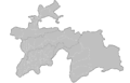 Tajikistan


Request: Please create location maps for each district within provinces (not within country), like this. The district names you can take from en-wiki or from here (for Kyrgyzstan). Anatoliy (talk) 16:15, 2 July 2010 (UTC)
Graphist opinion(s):
B52 Map
Request: It's being claimed as fair use on the English Wikipedia, which I doubt is acceptable under en.WP's fair use policies. Is there anyone someone could turn that into a map using free imagery? File:Fairchild_B-52_crash_overview.png is a diagram based version of the same incident. --Prosfilaes (talk) 05:22, 19 August 2010 (UTC)
Graphist opinion(s):
Tibetan Settlements in India location map
-
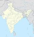 India location map

Request: Would it be possible to modify such a map to indicate places were the Tibetan diaspora is mostly located. It would be nice to use in the articles on the Tibetan diaspora in 5 languages, (fr/en/nl/es/eo) like: http://en.wikipedia.org/wiki/Tibetan_diaspora, as well as in a number of articles on the Tibetan diaspora. Here is a map with lots of details : http://www.tibetgov.net/set-map.htm There are 2 options : one is to indicate the places, the other one, more simple, is to make a location map called "Tibetan diaspora location map" showing India, Bhutan and Nepal in white.
Rédacteur Tibet (talk) 19:42, 29 October 2010 (UTC)
- http://www.tibetgov.net/set-map.htm is not working. Is there any other map to refer? --Jayarathina (talk) 10:10, 5 December 2012 (UTC)
Graphist opinion(s):
Coalicion contra Gadafi 2011.svg
-
 First original image
 -
2nd original image, used for 2nd and 3rd versions of the Spanish translated image.

Request: I've uploaded this translated version after changing text with Inkscape. Then, in 2nd and 3rd versions I've used the second original translatable image and I've "embedded all images", but nothing happens. I've checked with W3C Markup Validation Service, been answered with 45 Errors, 4 warning(s)! :O Can you help me to get it corrected, please? DPC (talk) 10:21, 25 March 2011 (UTC)
Today, system banner says: System notice: The thumbnail server is currently undergoing maintenance. Thumbnails may be broken. We will restore full service as soon as possible. Could this be the reason? --DPC (talk) 06:51, 31 March 2011 (UTC)
It wasn't. --DPC (talk) 09:39, 5 April 2011 (UTC)
Graphist opinion(s):
Republic of Venice
Request: Is it possible for you to redraw this map of Republic of Venice's Terra Ferma? Is the most complete work i know. Lord Hidelan 08:11, 13 June 2011 (UTC)
Graphist opinion(s):
Clean map of US area codes
I noticed there is not a single map on Commons which shows all the US area codes. Could we create one? To get started, I uploaded File:Area codes & time zones US.jpg. But this isn't sufficient because it has time zone data, because it is littered with in-image verbage, and because it's a jpeg.
It would be best if the image were in SVG format, so that it could be easily changed when a new area code is introduced (as happens fairly frequently). Magog the Ogre (talk) 02:46, 30 July 2011 (UTC)
Maps of Agra
-
Map of Agra, India
-
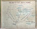 Map of Agra Fort

Request: Not a request, but a suggestion: maps of Agra could be made from these. Yann (talk) 17:19, 15 January 2012 (UTC)
Graphist opinion(s):
Map with many inaccuracies for legality of Salvia divinorum by jurisdiction
-
 Legal status of Salvia Divinorum by jurisdiction

Request: This map is very incorrect, and desprately needs to be recolored so that the map remains true to the real legal status of the substance. Specifically:
The following states are marked as areas where the substance is banned, however, they are not; they have only introduced legislation and they have not been approved yet. I request that a new color be added to the map to represent jurisdictions where legislation is pending and the outcome is not yet known:
- New York
- New Jersey
- Indiana
- South Carolina
- Texas
- Massachusetts
- Pennsylvania
- Utah
- Alaska
- Maryland (Note that Maryland is not colored as a banned jurisdiction like the previous ones)
Additionally, the following areas either are colored wrong, or are not colored at all, when they should be marked as areas where it is banned:
- Alabama
- Connecticut
- Delaware
- Florida
- Illinois
- Kansas
- Kentucky
- Louisiana
- Minnesota
- Mississippi
- Missouri
- North Carolina
- North Dakota
- Oklahoma
- South Dakota
- Tennessee
I used http://en.wikipedia.org/wiki/Legal_status_of_Salvia_divinorum for reference. Please note that I may have missed a few places, so please double check. The only places that seem to have problems are individual states in the US.
Thank you! --FarnhamJ (talk) 01:42, 28 January 2012 (UTC)
Graphist opinion(s):
Need help with a pixelated map
-
 A map of Gran Sabana National Park, showing also the location in Venezuela.

Request: Please help me smooth out this image. The topper part of the diagram is strongly pixelated. Maybe it could be vectorized with lines or improved in some way. The lines of the states in Venezuela don't necessarily need to be present. Image doesn't have to be perfect. But I need to minimize the difference between the top map and the lower map, cos' right now it looks really mediocre! If you open the file you'll see what I'm talking about. The file is important for the article http://es.wikipedia.org/wiki/Archivo:Gran_Sabana_Map.jpg which is pretty complete so far. The lower diagram can be modified too if desired, with less details as well, or can be left the same. Any help would be strongly appreciated, thanks for your time. Regards, Paolo Costa (talk) 02:24, 31 January 2012 (UTC)
Graphist opinion(s):
State of Sequoyah map

Request: A new clearer map needs to be created to allow for greater user readability, as it stands right now it hard to read the county names that are shown in the image. Also if it could be in SVG format. Dcheagle 21:55, 13 February 2012 (UTC)
Is anyone going to work on this.--Dcheagle 02:49, 12 March 2012 (UTC)
- I take it no one is Available to handle this request.--Dcheagle 07:22, 7 May 2012 (UTC)
- It is a very difficult task without high-quality source data. Powers (talk) 01:23, 8 May 2012 (UTC)
- What would be needed--Dcheagle 02:41, 26 May 2012 (UTC)
- Either a scan of a higher-quality map (this one is difficult to read in some spots, and the thickness of the lines causes ambiguity in some places), or a textual description of the boundaries of every county on the map. Or detailed coordinate data. As is, someone could trace the map you provided, but the result would risk being inaccurate, even if the text was more readable. Powers (talk) 02:34, 28 May 2012 (UTC)
- I may be able to find a higher quality map it may take me a few days to locate it though--Dcheagle 18:38, 28 May 2012 (UTC)
- I have found a Higher quality map--Dcheagle 02:18, 31 May 2012 (UTC)
- That's about as high quality a scan as possible for that particular map. My point, though, was that a) it will take a long time to trace it and b) even so there will be some errors inherent in the tracing, simply because it is coming from a tracing and not from actual geophysical data. Powers (talk) 02:17, 3 June 2012 (UTC)
- It may be useful to simply take the Oklahoma county map and highlight all the counties that are depicted in that historical map. Dominic (talk) 06:10, 12 June 2012 (UTC)
- That Could work the only problem that I would see with doing that is that the upper counties dont quite match up with there counter parts on the Sequoyah map. Comes close though which would be fine with me, at this point I'm looking for any thing that would work.--Dcheagle 01:12, 14 June 2012 (UTC)
- It may be useful to simply take the Oklahoma county map and highlight all the counties that are depicted in that historical map. Dominic (talk) 06:10, 12 June 2012 (UTC)
- That's about as high quality a scan as possible for that particular map. My point, though, was that a) it will take a long time to trace it and b) even so there will be some errors inherent in the tracing, simply because it is coming from a tracing and not from actual geophysical data. Powers (talk) 02:17, 3 June 2012 (UTC)
- I have found a Higher quality map--Dcheagle 02:18, 31 May 2012 (UTC)
- I may be able to find a higher quality map it may take me a few days to locate it though--Dcheagle 18:38, 28 May 2012 (UTC)
- Either a scan of a higher-quality map (this one is difficult to read in some spots, and the thickness of the lines causes ambiguity in some places), or a textual description of the boundaries of every county on the map. Or detailed coordinate data. As is, someone could trace the map you provided, but the result would risk being inaccurate, even if the text was more readable. Powers (talk) 02:34, 28 May 2012 (UTC)
- What would be needed--Dcheagle 02:41, 26 May 2012 (UTC)
- It is a very difficult task without high-quality source data. Powers (talk) 01:23, 8 May 2012 (UTC)
Graphist opinion(s):
Korridor train
-
 Example of image to create
 -
 My trial


Request: I'm asking if somebody can create a new image, representing the rail way path from Innsbruck to Lienz, passing through Italy. I don't know how to do it, but the example image may help a volounteer... Thanks in advance. Llorenzi (talk) 17:36, 3 April 2012 (UTC)
- Today I try to it by using for the background Google Maps-For-Free. What do you think about it? --Llorenzi (talk) 15:24, 12 April 2012 (UTC)
Graphist opinion(s):
Map of Rio de Janeiro's east side
-
 Map of Rio de Janeiro's east side (SVG)
.svg)
Request: This map was extracted from OpenStreetMap and it seems to have some flaws, maybe non-valid code. It turned out to be very difficult to edit. I cannot see objects outside the page borders (on Inkscape) and is very hard to change the highways color, for example. Could someone take a look at it? Best regards; Felipe Menegaz 01:50, 12 August 2012 (UTC)
Graphist opinion(s):
@Felipe Menegaz: It' s a very complex map with a LOT OF information and very heavy to work with. There is a clipping or a mask which has to be released to get to the things outside the page. You could probably find the roads by searching for there colors and change them in that way. But to me the main question is, Do you REALLY need a map with all that information?
Would it not be better to make a map with just the content you need? --Goran tek-en (talk) 19:03, 11 February 2014 (UTC)
blank map, or Arabic
-
 Eastern Hemisphere in 565 AD
 -
 Operation Desert storm
 -
 ParisPeace-Venizelos-Map


Request: Can you please provide an Arabic version of these files, if not then a blank version and i'll add the Arabic text, thank you--باسم (talk) 15:56, 3 September 2012 (UTC)
Graphist opinion(s):
Portuguese translation request for East Timor images
Hi! There are two East Timor-related images in English:
-

-

-
 Portuguese of second file


Here is a guide for what needs to be changed to make them into Portuguese:
- Atauru (Wetar)->Ataúro (Wetar)
- Northern Tetun -> Tétum do norte
- Southern Tetun -> Tétum do sul
- Other names of the languages do not change
- Austronesian Languages->Idiomas austronesianos
- No datas available->Não há datas disponíveis
- Languages of East Timor->Línguas do Timor-Leste
- Papuan Languages->Línguas de Papua-Nova Guiné
- Minority Language->língua minoritária
- Dialects->Dialetos
- National language->Idioma nacional
- Cities->Cidades
I thank User:Érico Júnior Wouters for the translations.
Thanks WhisperToMe (talk) 01:38, 11 September 2012 (UTC)
One of the German editors uploaded the Portuguese of File #2 (but it still needs a Portuguese description). File #1 has not yet been translated. WhisperToMe (talk) 22:57, 11 September 2012 (UTC)
French language maps
-
 Micronesia map
 -
 Migrations of Austronesians
 -
Migrations of Austronesians #2


Request: Please make English versions of these maps. Here is a key of what to use:
- Micronésie -> Micronesia
- Melanésie -> Melanesia
- Hawaï -> Hawaii
- Île de Pâques) -> Easter Island
- Îles de la société -> Society Islands
- Fidji -> Fiji
- Nouvelle-Zélande -> New Zealand
- États-Unis et Canada -> United States and Canada
- Taïwan -> Taiwan
- Indonésie -> Indonesia
- Moyen-Orient -> Middle East
Also for map #1 please change incorrect spellings to correct ones:
- Micronesie -> Micronésie
- Melanesie -> Melanésie
- Ile de Paque -> Île de Pâques
- Iles de la société -> Îles de la société
Thanks, WhisperToMe (talk) 05:04, 17 October 2012 (UTC)
Graphist opinion(s):
Persian version of University of Texas ethnographic map of Iran
-
 English map

Request: Please make a person version of the English map above. Here are some terms to use:
| English | Persian |
|---|---|
| Yerevan | ایروان |
| Armenia | ارمنستان |
| Baku | باکو |
| 0 | ۰ |
| 100 | ۱۰۰ |
| 200 | ۲۰۰ |
| Kilometers | کیلومتر |
| Miles | مایل |
| Boundary representation is not necessarily authoritative | مرزهای نمایشدادهشده لزوماً معتبر نیستند |
| Uzbekistan | ازبکستان |
| Turkmenistan | ترکمنستان |
| Turkey | ترکیه |
| Caspian Sea | دریای خزر |
| Ashgabat | عشقآباد |
| Orumiyeh | ارومیه |
| Tabriz | تبریز |
| Ardabil | اردبیل |
| Azerbaujan-e Gharbi | آذربایجان غربی |
| Azerbayjan-e Sharqi | آذربایجان شرقی |
| Rasht | رشت |
| Gilan | گیلان |
| Sari | ساری |
| Mazandaran | مازندران |
| Gorgan | گرگان |
| Golestan | گلستان |
| Mashhad | مشهد |
| Kordestan | کردستان |
| Sanandaj | سنندج |
| Zanjan | زنجان |
| Qazvin | قزوین |
| Tehran | تهران |
| Semnan | سمنان |
| Kermanshah | کرمانشاه |
| Hamadan | همدان |
| Markazi | مرکزی |
| Arak | اراک |
| Qom | قم |
| Semnan | سمنان |
| Khorasan | خراسان |
| Ilam | ایلام |
| Lorestan | لرستان |
| Khorramabad | خرمآباد |
| Esfahan | اصفهان |
| Chahar Mahall va Bakhtiari | چهارمحال و بختیاری |
| Shahr-e Kord | شهرکرد |
| Yazd | یزد |
| Khuzestan | خوزستان |
| Ahvaz | اهواز |
| Khorramshahr | خرمشهر |
| Abadan | آبادان |
| Yasuj | یاسوج |
| Kohgiluyeh va Buyer Ahmad | کهگیلویه و بویراحمد |
| Shiraz | شیراز |
| Fars | فارس |
| Kerman | کرمان |
| Zahedan | زاهدان |
| Sistan va Baluchestan | سیستان و بلوچستان |
| Afghanistan | افغانستان |
| Pakistan | پاکستان |
| Bushehr | بوشهر |
| Hormozgan | هرکمزگان |
| Bandar 'Abbas | بندر عباس |
| Baghdad | بغداد |
| Iraq | عراق |
| Kuwait | کویت |
| Saudi Arabia | عربستان سعودی |
| Persian Gulf | خلیج فارس |
| Strait of Hormuz | تنگهٔ هرمز |
| Gulf of Oman | دریای عمان |
| Arabian Sea | دریای عرب |
| Doha | دوحه |
| Qatar | قطر |
| Abu Dhabi | ابوظبی |
| United Arab Emirates | امارات متحدهٔ عربی |
| Oman | عمان |
| Muscat | مسقط |
| Shia | شیعه |
| Sunni | سنی |
| Persian | فارس |
| Azeri | آذری |
| Kurd | کرد |
| Arab | عرب |
| Lur | لر |
| Baloch | بلوچ |
| Qashqai | قشقایی |
| Turkmen | ترکمن |
| Gilaki | گیلکی |
| Mazandarani | مازندرانی |
| Talysh | تالش |
| Other | غیره |
| Sparsely populated | کمجمعیت |
| Province boundary | مرز استان |
If you need more Persian (of the surrounding countries?) Please let me know and I will add more or ask a Persian speaker for the Persian
--WhisperToMe (talk) 16:10, 29 November 2012 (UTC)
Graphist opinion(s):
Map in page 100
Request: can you please create a map like this one in page 100?--باسم (talk) 23:10, 3 March 2013 (UTC)
Graphist opinion(s):
Eriophorum angustifolium distribution map
-
 This image can be used as a base...
 -
 ...And/or this one.
 -
 This would be an example of the desired outcome.


Request: Can somebody create a map of the distribution of Eriophorum angustifolium using this map as a guide? File:Utricularia distribution.svg is a great example of how this simple enough map could (or should) look. 2.27.184.4 15:39, 14 March 2013 (UTC)
Graphist opinion(s):
New Request
Article(s): [[]]
Request:
- A Mercator map that don't have huge dot to represent microstates/small countries and centered at Asia (150°E)--$200inaire (talk) 00:56, 24 July 2013 (UTC)
Graphist opinion(s):
adding US state borders to world map
Just need one of the following:


Article(s): en:Same-sex marriage, en:LGBT adoption, and related articles
Request:
- Could we have the borders of the 48 contiguous US states fitted to File:BlankMap-World6.svg? We've been adding them one by one to the maps above, but there are enough of them now that the distortions we've introduced are starting to interfere with each other.
- As a secondary priority, state boundaries for Mexico and Australia may prove useful in the next couple years, but the hack job I've done is good enough for now.
- If you work on the blank world map, I can copy it over to the other two myself (assuming I can copy & paste from it in Inkscape). If there already is a version of this map w subnational boundaries, please just point it out and I'll take it from there. --Kwamikagami (talk) 23:05, 14 February 2014 (UTC)
Graphist opinion(s):
- It's a problem that the other maps we have with all the states has another point of center, projection and so on. There is this file BlankMap-USA-states-Canada-provinces, HI closer, is that what you want regarding the 48 states of US?
- It doesn't really fit so I'm not sure what to do. I might be able to tweak it in, but then it wont be accurate (if there is such a thing with maps).
- This is a blank base map so I think we should do it really accurate. --Goran tek-en (talk) 19:25, 11 March 2014 (UTC)
- Yes, that's what I was looking for. I thought you might know the point-of-center and projection, and could therefore adjust another map to fit. If you can't, then we might as well stick with the hack job I'm doing. Kwamikagami (talk) 08:25, 12 March 2014 (UTC)
- I don't but maybe someone else does. So if you don't get any other response or you decide to do it your self please close this request. --Goran tek-en (talk) 15:31, 12 March 2014 (UTC)
- Yes, that's what I was looking for. I thought you might know the point-of-center and projection, and could therefore adjust another map to fit. If you can't, then we might as well stick with the hack job I'm doing. Kwamikagami (talk) 08:25, 12 March 2014 (UTC)
close up needed


Article(s): en:Haryana en:Indian general election, 2014 (Haryana) and many more.
Request:
- can i get a close up for the coloured state in svg. --Khushank94 (talk) 08:04, 25 April 2014 (UTC)
- Here you are: Haryana map --Maxxl2 - talk 08:13, 25 April 2014 (UTC)
- The borders in this map shows district but i need constituencies as in File:Lok Sabha constituencies of India.png
- I would also prefer if you can convert File:Lok Sabha constituencies of India.png as a whole in svg -Khushank94 (talk) 08:57, 25 April 2014 (UTC)
- Here you are: Haryana map --Maxxl2 - talk 08:13, 25 April 2014 (UTC)
Lok Sabha Constituency maps required
Article(s): en:Category:Lok Sabha constituencies in Odisha
Request:
- Need 21 individual maps for the Lok Sabha constituencies In Odisha. The reference map may be found at Parliamentary constituencies of Odisha and Odisha Schedule. --Mrutyunjaya Kar (talk) 08:10, 29 April 2014 (UTC)
Graphist opinion(s):
assembly constituencies map
Article(s): 1, 2, 3 and en:Elections in Haryana
Request:
- can you please make a empty and a same coloured map from this or probably File:India Haryana locator map.svg(but this shows parliamentary not assembly constituencies)--Khushank94 (talk) 13:39, 23 May 2014 (UTC)
Graphist opinion(s):
Corrections to Basilan maps
-
 Al-Barka - wrong location and revised borders needed
 -
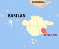 Tipo-Tipo - wrong location and revised borders needed
 -
 Ungkaya Pukan - revised borders needed


Request:
- Please update the 3 maps above, using these base maps: File:Ph fil basilan.png or File:Basilan Political Map (as of 2011).jpg. Thanks. --P 1 9 9 ✉ 15:05, 22 August 2014 (UTC)
Graphist opinion(s):
Telangana Boundaries


Article(s): en:Politics of India
Request:
- Please add Boundaries of newly created Indian State en:Telangana like 2nd image. --Prateek Malviyatalk 04:31, 4 September 2014 (UTC)
Graphist opinion(s):
- I'm sorry but I don't really understand what you want us to do. I think you have to explain it more in detail. Remember that we have zero knowledge of the subject, thanks. --Goran tek-en (talk) 19:49, 2 December 2014 (UTC)
Palghar: Maharashtra's new district
-
 Maharashtra location map (svg format)
 -
 Maharashtra divisions (svg format)
 -
 Maharashtra location map (svg format)


Article(s): Multiple articles
Request:
- A new district of en:Palghar district has been created out of the old en:Thane district (the top left most region). Check these references [6],[7] which might be useful to know where Palghar is. In case more info is needed, please ping. Am currently nominating the most used images first. But a large number of images from Category:Locator maps of divisions of Maharashtra and Category:Locator maps of Maharashtra and categories within it would need changing. §§Dharmadhyaksha§§ {T/C} 16:58, 14 September 2014 (UTC)
Graphist opinion(s):
Southern Sudan
-
 Tulunid Emirate 868 - 905 (Arabic)
 -
 Tulunid Emirate 868 - 905 (English)
 -
 South Sudan
-ar.PNG)
.PNG)
_(-mini_map_-rivers).svg)
- Article(s)
- الدولة الطولونيَّة
- Request
- Please add the boarders of South Sudan to both the English and Arabic maps. This map says "the modern boundaries of the Arab world", yet it shows a map of Sudan prior to 2011, when the southern part of the country gained independence. Thank you--باسم (talk) 22:58, 2 July 2015 (UTC)
- Graphist opinion(s)
![]() Request taken by Goran tek-en (talk) 19:07, 15 July 2015 (UTC)
Request taken by Goran tek-en (talk) 19:07, 15 July 2015 (UTC)
![]() Done:This section was archived on a request by: Goran tek-en (talk) 19:34, 15 July 2015 (UTC)
Done:This section was archived on a request by: Goran tek-en (talk) 19:34, 15 July 2015 (UTC)
County locations in Texas maps


- Article(s)
- en:Buchel County, Texas, en:Encinal County, Texas, en:Foley County, Texas, en:Greer County, Texas , en:Wegefarth County, Texas, en:Worth County, Texas
- Request
- missing maps needed for uses of en:Template:Infobox U.S. county that popped up in en:Category:Articles with missing files --KylieTastic (talk) 19:53, 15 June 2015 (UTC)
- Graphist opinion(s)
![]() Done did it myself - not great, but gives the reader a rough idea (and removes the template errors) KylieTastic (talk) 19:06, 29 June 2015 (UTC)
Done did it myself - not great, but gives the reader a rough idea (and removes the template errors) KylieTastic (talk) 19:06, 29 June 2015 (UTC)
- This section was archived on a request by: Storkk (talk) 13:02, 5 August 2015 (UTC)
- Article(s)
- ru:Реликтовый дровосек
- Request
- The uploader claimed in my talkpage, that he found the bug from somewhere in internet and it is maybe protected with copyright. The map needs to get rid of bug. Please somebody paint the bug blue. Taivo (talk) 17:39, 21 June 2015 (UTC)
- Graphist opinion(s)
![]() Done @Taivo: You might want to nuke the old version. Revent (talk) 22:44, 23 June 2015 (UTC)
Done @Taivo: You might want to nuke the old version. Revent (talk) 22:44, 23 June 2015 (UTC)
- This section was archived on a request by: Storkk (talk) 13:02, 5 August 2015 (UTC)
Simplified Chinese versions of MH370 images
-
 search March through October 2014
 -
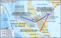


- Article(s)
- MH370
- Request
- Simplified Chinese translations of the following maps requested:
Key for File:MH370 search March through October 2014.svg
- Towed Pinger Loctor search & Sonar survey (4 April-28 May) - 拖行声波定位器搜索和声纳调查(4月4日至5月28日)
- 103o 50'E - 东经103度50分
- 21o 10'S - 南纬21度10分
- 104oE (and so on with the degrees) - 东经104度
- Depth (metres) - 深度(米)
- Elevation (metres) - 海拔 (米)
- Detected by sonobouy - 由声纳浮标所检测
- Indian Ocean - 印度洋
- Cocos Is. (Australia) - 科科斯群島 (澳洲)
- The Search for Malaysia Airlines Flight 370 - 搜寻马来西亚航空公司370航班
- March through October 2014 - 3月至2014年10月
- Search Areas 3-11 April - 4月3日至11日的搜索区域
- Towed Pinger Locator Search - 拖行声波定位器搜索
- Seafloor Sonar Survey (left inset) - 海底声纳调查(左小图)
- Exmouth RAAF Learmouth - Exmouth市镇 (break)Learmonth机场的澳大利亚皇家空军
- Search areas 12-28 April - 4月12日至28日的搜索领域
- Calculated flight path (29 March-3 April) - 所计算出的飞行路线(3月29日至4月3日)
- Path of ADV Ocean Shield with Towed Pinger Locator (4-14 April) - 海洋之盾号与拖行声波定位器的路径(4月4日至14日)
- Acoustic detections - 声音检测器
- Max. effective TPL detection range (3 km) - 拖行声波定位器的最大有效检测范围(3公里)
- Seafloor sonar survey (14 April-28 May) - 海底声纳调查(4月14日至5月28日)
- Sources: Australian Transport Safety Bureau & Phoenix International - 资料来源:澳洲交通安全局与凤凰国际
- Background: Whiteway, T., 2009. Australian Bathymetry and Topography Grid, June 2009. Scale 1:5000000. Geoscience Australia, Canberra. - 背景来源:《澳大利亚海洋测深与地形网格》,尺度 1:5,000,000。作者:Whiteway,T., 由澳洲堪培拉地球科学局于2009年6月发布。
- Sonobuoy deployments - 声纳浮标部署
- Underwater search (commenced October 2014) - 水下搜索(于2014年10月展开)
- Initial (priority) search area - 最初的优先搜索区域
- Wide search area - 广泛搜索区域
- Satellite images of possible debris: - 卫星图像所显示的可能碎片
- Thaichote (24 March) - 泰国地球观测卫星(3月24日)
- Gaofen-1 (18 March) - 高分一号卫星 (3月18日)
- Airbus (23 March) - 空客防务卫星(3月23日)
- Digital Globe (16 March) - 數位全球公司卫星(3月16日)
- Sources: Australia Maritime Safety Authority & Australian Transport Safety Bureau - 资料来源:澳洲海事安全局和澳洲交通安全局
Key for File:MH370 initial search Southeast Asia.svg
- Malaysia Airlines Flight 370 Initial search areas - March 8-16 - 马航370航班的最初的搜索区域(3月8日至16日)
- Flight 370 departs Kuala Lumpur International Airport (0:41 MYT) - 370航班离开吉隆坡国际机场 (大马标准时间 0:41)
- Contact with Flight 370 is lost. It disappears from secondary radar, & deviates from planned flight path (1:19-1:21 MYT) - 与370航班失去联系。它从二次雷达中消失,以及偏离原本的飞行路程(大马标准时间 1:19至1:21)。
- Final sighting (on military radar), 370km from Penang Island. (2:22 MYT) Note: Not publicly disclosed until 12 March. - 最后目击在于军用雷达,距离槟岛370公里(大马标准时间 2:22)。注:不对外公开披露,直到3月12日。
- Elevation (metres) - 海拔(米)
- Malaysia - 马来西亚
- Indonesia - 印度尼西亚
- Thailand - 泰国
- Vietnam - 越南
- 10oN (and so on) - 北纬10度 (replace the numbers with whatever is appropriate)
- 100oE (and so on) - 东经100度 (replace the numbers with whatever is appropriate)
- Andaman Islands (India) - 安达曼群岛 (印度)
- Indian Ocean - 印度洋
- Andaman Sea - 安达曼海
- Strait of Malacca - 马六甲海峡
- Gulf of Thailand - 泰国湾
- South China Sea - 南中国海
- Kuala Terengganu - 瓜拉登嘉楼
- Singapore - 新加坡
- Kuala Lumpur - 吉隆坡
- George Town (Penang Is.) - 乔治市(槟岛)
- Banda Aceh - 亚齐
Translations by User:Cerevisae
--WhisperToMe (talk) 12:15, 9 August 2015 (UTC)
- Graphist opinion(s)
- @WhisperToMe: @Cerevisae: You're missing a couple translations for the third map:
"7th arc" – Distance from satellite at time of last contact with Flight 370 (8:11 MYT)- and please indicate where it makes sense to split into three lines - “第七弧线” - 当370航班最后一次联系时 (break) 与卫星之间的距离 (break)(大马标准时间 8:11)Broken Ridge- 布罗肯海岭Above sea level- 海拔- "海洋之盾号与拖行声波定位器的路径(4月4日至14日)" into two lines - 海洋之盾号(break)与拖行声波定位器的路径(4月4日至14日)
Île Amsterdam (France)- 阿姆斯特丹岛 (法国) andÎle Saint-Paul (France)- 圣保罗岛(法国)Background (except upper left inset): Natural Earth. Map by Andrew Heneen (November 2014). Licensed CC-by-SA-3.0- 背景来源(除了左上小图):《自然大地》地图由Andrew Heneen于2014年11月所创作。拥有“创作共用授权 - 署名 - 相同方式共享”条款的许可。km- 公里 andmi- 英里Cape Leeuwin- 露纹角Great Australian Bight- 大澳洲湾RAAF Learmonthas separate from Exmouth - Exmouth市镇 (break)澳大利亚皇家空军的Learmonth机场RAAF Base Perce- 澳大利亚皇家空军的皮尔斯基地 andFremantle Harbour- 弗里曼特尔海港- Everything in both lower right insets -
Translations for lower left smaller inset:
- Beijing Scheduled arrival 6:30 CST - 北京 (break) 预计抵达(中国标准时间 6:30)
- Note: MYT and CST time zones had the same time on 8 March 2014 (UTC+8) - 注:大马标准时区和中国标准时区(break)在2014年3月8日当天(break)都是相同的(协调世界时+8小时)
- Kuala Lumpur Departed 0:41 MYT - 吉隆坡 (break) 于大马标准时间 8:11 启程
- I presume this is a mistake and is supposed to read 于大马标准时间 0:41 启程 ? If not please let me know. Storkk (talk) 10:08, 11 August 2015 (UTC)
- Ping Corridors announced 17 March - 于3月17日所宣布的(break)两个声波走廊
- Initial search (bottom right inset) - 最初的搜索(右下小图)
- Inmarsat 3-F1 35,800km above sea level - 国际海事卫星组织的3-F1卫星(break)位于海拔35,800公里
- Main map - 主要地图
- Sources: Inmarsat & Malaysian Dept. of Civil Aviation - 资料来源:国际海事卫星组织与马来西亚民航局
Translation for lower right bigger inset is available above as File:MH370 initial search Southeast Asia.svg
- Thanks, Storkk (talk) 13:43, 10 August 2015 (UTC)
- Thanks for letting me know! I notified Cerevisae WhisperToMe (talk) 13:54, 10 August 2015 (UTC)
- Thanks for this - I'll attempt the two SVGs but can't do the PNGs. Storkk (talk) 16:55, 10 August 2015 (UTC)
- Thanks Storkk for your help :-) Cerevisae (talk) 17:21, 10 August 2015 (UTC)
- @WhisperToMe: @Cerevisae: Missing the title and the legend for the lower right inset, and please see my previous question above, but I've uploaded what we have so far as File:The Search for Malaysia Airlines Flight 370 (March through October 2014) zh.svg. I'd appreciate a thorough check as I don't understand what I'm copying/pasting and may have made errors! Also, I have just translated the labels and made cosmetic changes: this file inherits the SVG errors that the original file had and I'm sure it could be made much smaller and better by an SVG guru. Thanks, Storkk (talk) 10:56, 11 August 2015 (UTC)
- @Storkk: I have made a thorough check on the translated image. It is quite good. Here are some corrections that I spotted:
- Thanks for letting me know! I notified Cerevisae WhisperToMe (talk) 13:54, 10 August 2015 (UTC)
- Main image: Change 搜寻马来西亚航空公司航班370 to 搜寻马来西亚航空公司370航班
- Main image: Change 3月至2014年10月 to 2014年3月至10月
- Lower left inset: Change 注:大马标准时区和中国标准时区(break)在2014年3月8日当天(break)都是相同的(协调世界时+8小时)to 注:大马标准时和中国标准时(break)在2014年3月8日当天(break)都是相同的(协调世界时+8小时)
- Lower right inset: Change 3月8日至16日的搜索领域 to 3月8日至16日的搜索区域
Now for the missed translations of right lower inset:
- Initial search efforts - 最初搜索工作
- Actual route (from secondary radar) - 实际路线(二次雷达所检测)
- Actual route (from military radar) - 实际路线(军用雷达所检测)
- Planned route - 原定路线
- Sources: Joint Investigation Team &Malaysian Dept. of Civil Aviation - 资料来源:联合调查组 (break) 与马来西亚民航局
Cerevisae (talk) 14:41, 11 August 2015 (UTC)
- Please have another look. If good, I will do the other SVG. Thanks, Storkk (talk) 17:01, 11 August 2015 (UTC)
- Just 3 other corrections and it is good to go. Thanks :-)
- Main image legend: Change 广泛搜索区域 to 大范围搜索
- Main image: Change 4月12日至28日的搜索领域 to 4月12日至28日的搜索区域
- Main image: Change 3月18日至27日的搜索领域 to 3月18日至27日的搜索区域 Cerevisae (talk) 20:58, 11 August 2015 (UTC)
- @Cerevisae: new version uploaded incorporating those three changes. Please let me know. Cheers, Storkk (talk) 13:31, 12 August 2015 (UTC)
- @Storkk: Thanks! No further changes required for this map. Good job! :-) Cerevisae (talk) 14:15, 12 August 2015 (UTC)
- @Cerevisae: Please check the second SVG map: File:The Search for Malaysia Airlines Flight 370 - Initial search areas (Southeast Asia) zh.svg. Thanks! Storkk (talk) 16:21, 13 August 2015 (UTC)
- @Storkk: This map is good to go. No changes needed. Thanks! :-) Cerevisae (talk) 20:30, 13 August 2015 (UTC)
- @WhisperToMe: I'd suggest splitting out the three PNG maps from this request into a new request so that they are more likely to be seen. Storkk (talk) 16:21, 13 August 2015 (UTC)
- @Storkk: Done :) WhisperToMe (talk) 22:38, 13 August 2015 (UTC)
- @Cerevisae: new version uploaded incorporating those three changes. Please let me know. Cheers, Storkk (talk) 13:31, 12 August 2015 (UTC)
- This section was archived on a request by: Storkk (talk) 13:52, 14 August 2015 (UTC)
Correction Request: The Armenian Apostolic Church is erroneously colored as being part of the Eastern Orthodox Church, but it is a separate Christian denomination.
-
 Europe religion map (1950).png
 -
 Europe religion map-ar.png
 -
 Europe religion map de.png
 -
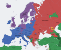 Europe religion map en.png
 -
 Europe religion map situation 1950 fr.png
.png)


- Article(s)
File:Europe religion map.png
File:Europe religion map-ar.png
File:Europe religion map de.png
File:Europe religion map en.png
File:Europe religion map fr.png
- Request
The Armenian Apostolic Church is erroneously colored (in red) as being part of the Eastern Orthodox Church in the map File:Europe religion map.png and in all in its different language versions File:Europe religion map-ar.png, File:Europe religion map de.png, File:Europe religion map en.png, File:Europe religion map fr.png etc., which is incorrect because it is a separate Christian denomination. Could you color Armenia and the breakaway Nagorno-Karabakh region of Azerbaijan in a different color in all these maps? -- IP User 31.200.10.222 (talk) 18:25, 27 December 2014 (UTC)
- Graphist opinion(s)
This seems to have been done in April by Ras67 Storkk (talk) 13:52, 17 August 2015 (UTC)
- This section was archived on a request by: Storkk (talk) 13:52, 17 August 2015 (UTC)
Spanish image request
-
 English image

- Article(s)
- es:METRORail
- Request
- Please make a Spanish version. The names of the stations should be the same. However there are descriptions below. These should be translated: "At (name)" becomes "en (name)" - "Between (name) and (name)" becomes "Entre (name) y (name)" - And "(name) at (name)" becomes "(name) y (name)" --WhisperToMe (talk) 00:56, 4 June 2015 (UTC)
- Graphist opinion(s)
@WhisperToMe: I've added the translation (did you mean "(name) en (name)" for "at"?) to the file and cleaned it up significantly so the text and translation are human-editable just by scrolling to the bottom of the file in Notepad (or similar). I think it would be worth adding translations for the P&R lot and Transit Center, but hopefully you can fill in the spaces for those yourself, as well as fixing any other translation errors. If you do still want or need help, though, just say the word. NikNaks talk - gallery - wikipedia 15:19, 4 July 2015 (UTC)
- @NikNaks: Thank you so much! I noticed the ping but had gotten caught up in other stuff. Anyway I'll see if there's anyplace where METRO translated "Park and Ride Lot" and "Transit Center" on its website. WhisperToMe (talk) 20:24, 11 August 2015 (UTC)
- From http://www.ridemetro.org/MetroPDFs/Schedules/METRORail-Maps-Schedules/METRORail-RiderGuide.pdf - http://www.webcitation.org/6ai7RIOi4 - Park & Ride is translated to Estacionamiento Park & Ride and Transit Center becomes Centro de Transporte, although the station names are not translated. WhisperToMe (talk) 20:26, 11 August 2015 (UTC)
- I'm using Jarry1250's tool to try to modify "Transit Centro" into "Centro de Transporte" and to add: "Park and Ride lot" "Estacionamiento Park & Ride" - However the form URL says "formerror" but I don't see what kind of error is happening??? WhisperToMe (talk) 20:36, 11 August 2015 (UTC)
- I've never tried using the tool with <switch> based translations, and I'm not sure if it's designed for it. If you download the file and open it with a notepad-style application, you should be able to see all the translations at the bottom of the file and do it that way. If that seems too daunting though, I'm happy to finish off the additional bits of text. NikNaks talk - gallery - wikipedia 22:17, 11 August 2015 (UTC)
- @NikNaks: Thank you, NikNaks! I tried uploading a modified file (I edited it in Notepad) but I keep getting "The XML in the uploaded file could not be parsed." I looked through the code and couldn't see how I was doing anything wrong in it... WhisperToMe (talk) 08:23, 12 August 2015 (UTC)
- @WhisperToMe: How odd. It's possible that Notepad encoded the file incorrectly, but that's the only thing I can think of. Regardless, I've made the changes. If you think that the station names containing "Transport Center" should be kept fully in English, unlike what I've done, just say so and I'll switch them back. NikNaks talk - gallery - wikipedia 09:15, 12 August 2015 (UTC)
- @NikNaks: Thank you so much! Anyway, the station names with "Transit Center" should be kept the same in Spanish because METRO renders the names of the stations as such in Spanish in its documents. When it's a generic "transit center" usage it's okay to say "centro de transporte". WhisperToMe (talk) 11:39, 12 August 2015 (UTC)
- @WhisperToMe: How odd. It's possible that Notepad encoded the file incorrectly, but that's the only thing I can think of. Regardless, I've made the changes. If you think that the station names containing "Transport Center" should be kept fully in English, unlike what I've done, just say so and I'll switch them back. NikNaks talk - gallery - wikipedia 09:15, 12 August 2015 (UTC)
- @NikNaks: Thank you, NikNaks! I tried uploading a modified file (I edited it in Notepad) but I keep getting "The XML in the uploaded file could not be parsed." I looked through the code and couldn't see how I was doing anything wrong in it... WhisperToMe (talk) 08:23, 12 August 2015 (UTC)
- I've never tried using the tool with <switch> based translations, and I'm not sure if it's designed for it. If you download the file and open it with a notepad-style application, you should be able to see all the translations at the bottom of the file and do it that way. If that seems too daunting though, I'm happy to finish off the additional bits of text. NikNaks talk - gallery - wikipedia 22:17, 11 August 2015 (UTC)
- I'm using Jarry1250's tool to try to modify "Transit Centro" into "Centro de Transporte" and to add: "Park and Ride lot" "Estacionamiento Park & Ride" - However the form URL says "formerror" but I don't see what kind of error is happening??? WhisperToMe (talk) 20:36, 11 August 2015 (UTC)
- From http://www.ridemetro.org/MetroPDFs/Schedules/METRORail-Maps-Schedules/METRORail-RiderGuide.pdf - http://www.webcitation.org/6ai7RIOi4 - Park & Ride is translated to Estacionamiento Park & Ride and Transit Center becomes Centro de Transporte, although the station names are not translated. WhisperToMe (talk) 20:26, 11 August 2015 (UTC)
- @NikNaks: Thank you so much! I noticed the ping but had gotten caught up in other stuff. Anyway I'll see if there's anyplace where METRO translated "Park and Ride Lot" and "Transit Center" on its website. WhisperToMe (talk) 20:24, 11 August 2015 (UTC)
- My bad. That should be it finished, then. :) NikNaks talk - gallery - wikipedia 15:01, 12 August 2015 (UTC)
- Thank you! One more small thing: The parking one should be "Estacionamiento Park & Ride" with the "and" being in English since METRO uses the English name "Park and Ride" in the Spanish. @NikNaks: WhisperToMe (talk) 16:47, 12 August 2015 (UTC)
- Aha! I've found out why you were getting an error. Typing an ampersand in UTF-8 encoded file causes an error, as it's a special character. You need to use the representation
& amp;instead (without a space). I've fixed the 'y' with said character, but now that we know why it broke you should be able to edit it should you find anything further. NikNaks talk - gallery - wikipedia 13:35, 14 August 2015 (UTC)- Cool! Thank you so much for finding that! I think this section is WhisperToMe (talk) 14:14, 15 August 2015 (UTC)
 Resolved
- Cool! Thank you so much for finding that! I think this section is
- Aha! I've found out why you were getting an error. Typing an ampersand in UTF-8 encoded file causes an error, as it's a special character. You need to use the representation
- Thank you! One more small thing: The parking one should be "Estacionamiento Park & Ride" with the "and" being in English since METRO uses the English name "Park and Ride" in the Spanish. @NikNaks: WhisperToMe (talk) 16:47, 12 August 2015 (UTC)
- This section was archived on a request by: WhisperToMe (talk) 14:14, 15 August 2015 (UTC)
Map of the Winnipeg travel (1939)
-
 Map of the Atlantic Ocean.
 -
 Example of a sea travel map.
_az.svg)

- Article(s)
- es:Winnipeg (barco), en:SS Winnipeg
- Request
- I need a map of the travel of the ship Winnipeg between France and Chile in 1939. We will do an edit-a-thon this Saturday about this travel, and would be really amazing having this map to illustrate the articles related. Best, --Warko (talk) 23:39, 31 August 2015 (UTC)
- Graphist opinion(s)
I guess this edit-a-thon has been planned for some time so we graphic workers would have appreciated some more time to complete this request (at least that is my opinion). --Goran tek-en (talk) 19:25, 2 September 2015 (UTC)
- Sure, I didn't say I want this image for the edit-a-thon itself, I only requested the image "to illustrate the articles related", so if it is designed after Saturday, it is fine too. Best, --Warko (talk) 20:57, 2 September 2015 (UTC)
![]() Request taken by Goran tek-en (talk) 18:41, 27 September 2015 (UTC)
Request taken by Goran tek-en (talk) 18:41, 27 September 2015 (UTC)
- @Warko: Now there is a draft to look at. Is Arica the right name, I couldn't read it? Give me feedback on this, thanks. --Goran tek-en (talk) 16:14, 3 October 2015 (UTC)
- @Goran tek-en: Thank you! Yes, Arica is correct. Could you get dark the color of the sea? Best, --Warko (talk) 01:08, 5 October 2015 (UTC)
- @Warko: New draft.
- I changed the colors so that they follow the map template we use, Maps template-en.
- If this OK I will need the following;
- Name of the file
- Description
- Category/ies at commons
- to be able to upload it at commons, thanks. --Goran tek-en (talk)
- @Goran tek-en:
It is Ok!Name: "File:SS Winnipeg journey (1939).jpg". Description: {{es|Mapa del viaje de los exiliados españoles en el buque ''Winnipeg'' entre Francia y Chile, en 1939.}}. Categories: [[Category:Winnipeg (ship, 1918)]], [[Category:Maps of Journeys]], and [[Category:Maps of maritime history]]. Thanks, --Warko (talk) 19:06, 5 October 2015 (UTC)- The dates are changed: it departed from France on 4 August 1939 (in Spanish: 04-08-1939) and arrived to Chile on 3 September 1939 (03-09-1939).--Warko (talk) 03:51, 6 October 2015 (UTC)
- @Goran tek-en:
- @Warko: New draft.
- @Goran tek-en: Thank you! Yes, Arica is correct. Could you get dark the color of the sea? Best, --Warko (talk) 01:08, 5 October 2015 (UTC)
- @Warko: Now there is a draft to look at. Is Arica the right name, I couldn't read it? Give me feedback on this, thanks. --Goran tek-en (talk) 16:14, 3 October 2015 (UTC)
Now you can find it here SS Winnipeg journey (1939). I had some problems with the text so I made it into outline. I guess this text won't be changed to often. --Goran tek-en (talk) 18:48, 16 October 2015 (UTC)
![]() Done
Done
- This section was archived on a request by: Goran tek-en (talk) 18:48, 16 October 2015 (UTC)
SVG version of Bounty Voyages Map.png
- This section was archived on a request by: Rowanwindwhistler (talk) 08:25, 7 November 2015 (UTC)
-
 voyages of HMS Bounty in the south Pacific
 -
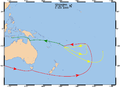 Label-less base map


- Article(s)
- es:Motín del HMS Bounty
- Request
- I would like to have a SVG version of this map done so that I can later create a Spanish version for the article mentioned above, currently nominated for featured in the Spanish Wikipedia. Thank you!--Rowanwindwhistler (talk) 08:17, 28 September 2015 (UTC)
- Graphist opinion(s)
@Rowanwindwhistler: There is no raw SVG version of the map, but there is a PNG version without most labels which allows you to add the Spanish labels by yourself in MSPaint or GIMP easily. -- Sameboat - 同舟 (talk · contri.) 02:17, 4 November 2015 (UTC)
- Though I would rather have SVG maps than non-vector ones, that would indeed be a way to go. I will see if I can find a base SVG map of the area and add the voyages to it (not sure if there is one). If not, I will consider using the PNG base map. Thanks for the suggestion.--Rowanwindwhistler (talk) 06:16, 4 November 2015 (UTC)
- @Rowanwindwhistler: You can try OpenStreetMap to crop the same region as best as you can and save as SVG format. -- Sameboat - 同舟 (talk · contri.) 07:06, 4 November 2015 (UTC)
- I have never tried that but I will next time I need a SVG base map. In the end I managed to find a map that shows roughly the same region and created a SVG version of the original map. I think we can mark this request as resolved. Many thanks for all your suggestions!--Rowanwindwhistler (talk) 07:31, 4 November 2015 (UTC)
- @Rowanwindwhistler: You can try OpenStreetMap to crop the same region as best as you can and save as SVG format. -- Sameboat - 同舟 (talk · contri.) 07:06, 4 November 2015 (UTC)
Typo in SVG map to be corrected
-
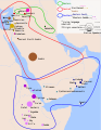 Distribution of the Semitic languages

- Article(s)
- en:Semitic languages among others
- Request
- Please correct "Ebalite" (at the top of the map, in northwestern Syria) to "Eblaite" (compare w:Eblaite language) —Angr 14:57, 3 November 2015 (UTC)
- Graphist opinion(s)
This SVG file contains real text so you can correct it by yourself. Just open the SVG file in Notepad or any other text editor like Notepad++. Press Ctrl+H and find "Ebalite" and replace with "Eblaite", save and upload again. Use this chance to familiarize yourself with simple SVG/XML source editing. -- Sameboat - 同舟 (talk · contri.) 02:09, 4 November 2015 (UTC)
 Done It worked! Thanks for your help. —Angr 22:05, 6 November 2015 (UTC)
- This section was archived on a request by: BMacZero (talk) 18:28, 10 November 2015 (UTC)
Convert PNG map to SVG
-
 Standard World Time Zones

- Article(s)
- All articles at Standard_World_Time_Zones.png#globalusage
- Request
- Can somebody convert this map to SVG format please? I'd be happy with just the background map, lines and colours, but if the text is converted too this would be fantastic --Gts-tg (talk) 14:51, 26 December 2015 (UTC)
- Graphist opinion(s)
To start with I think you should look at this svg file here and then request changes on that if needed. We do not need to redo work which has been done before, thanks. --Goran tek-en (talk) 19:21, 27 December 2015 (UTC)
- Thank you, I was not aware there was a slightly different version in SVG. I have now added a link to this file to the other versions section of the original PNG image Gts-tg (talk) 03:49, 29 December 2015 (UTC)
- So do you want to close this request as Done, or do you still want someone to take it and work on it? And if so, you will have to be more specific in what to do, thanks. --Goran tek-en (talk) 16:18, 29 December 2015 (UTC)
- This section was archived on a request by: Storkk (talk) 12:57, 16 February 2016 (UTC)
Spanish version of File:Avianca52SeatMap.png
-
 English version
 -
 Vectorized English version
 -
 Vectorized Spanish version


- Article(s)
- es:Vuelo 52 de Avianca
- Request
- Please make a Spanish version of: File:Avianca52SeatMap.png
Key with translations by User:Ganímedes
   Main Boarding Door - Puerta de abordaje principal
   First Class - Primera clase
   Minor injury: Daño menor
   Serious Injury - Daño mayor
   Fatal Injury - Daño mortal
   NOTE: Diagram not to scale - NOTA: Diagrama fuera de escala
   Long text: No se puede determinar el arreglo preciso de todos los ocupantes en relación a sus daños debido a que no se asignaron todos los asientos y algunos pasajeros fueron movidos a asientos diferentes luego de abordar.
Additional words from https://books.google.com/books?id=hx1TcFb8YrIC&pg=PA791 and https://books.google.com/books?id=hx1TcFb8YrIC&pg=PA163
forward galley door = puerta de cocina delantera
additional words from https://books.google.com/books?id=hx1TcFb8YrIC&pg=PA15
Aft Entry Door and Aft Galley Door = puerta de entrada trasera, puerta de cocina trasera
additional words from https://books.google.com/books?id=hx1TcFb8YrIC&pg=PA847
Type III Overwing Door = Puerta sobre el ala tipo III
--WhisperToMe (talk) 17:23, 11 August 2015 (UTC)
- Graphist opinion(s)
- I have made an SVG version (linked above) which will make translation easier. --Amble (talk) 17:30, 28 September 2015 (UTC)
- Now added the Spanish version. Done --Amble (talk) 18:49, 28 September 2015 (UTC)
- Now added the Spanish version.
- This section was archived on a request by: Goran tek-en (talk) 18:17, 3 July 2016 (UTC)
Age of Consent
-
 Global age of consent
 -
 North America


- Article(s)
- Many
- Request
- Add details for Mexico to File:Age of Consent - Global.svg, as was done for the United States and Australia. --Delphi234 (talk) 03:17, 27 May 2015 (UTC)
- Graphist opinion(s)
I think this was actually done (by User:Gajmar on 11:44, 11 December 2016). I would mark this as resolved.--Lommes (talk) 21:25, 28 April 2017 (UTC)
- This section was archived on a request by: Lommes (talk) 21:25, 28 April 2017 (UTC)
MH370 PNG maps - Chinese requested
-
 Flight path
 -
 SVG
SVG -
 ATC and air routes
 -


.svg)
![[1]](https://commons.wikimedia.org/wiki/File:Ostfront_18021915.jpg)
![[2]](https://commons.wikimedia.org/wiki/File:EasternFront1915b.jpg)
![[3]](https://commons.wikimedia.org/wiki/File:EasternFront1916a.jpg)
![[4]](https://commons.wikimedia.org/wiki/File:EasternFront1914a.jpg)
.svg)
.svg)
.svg)
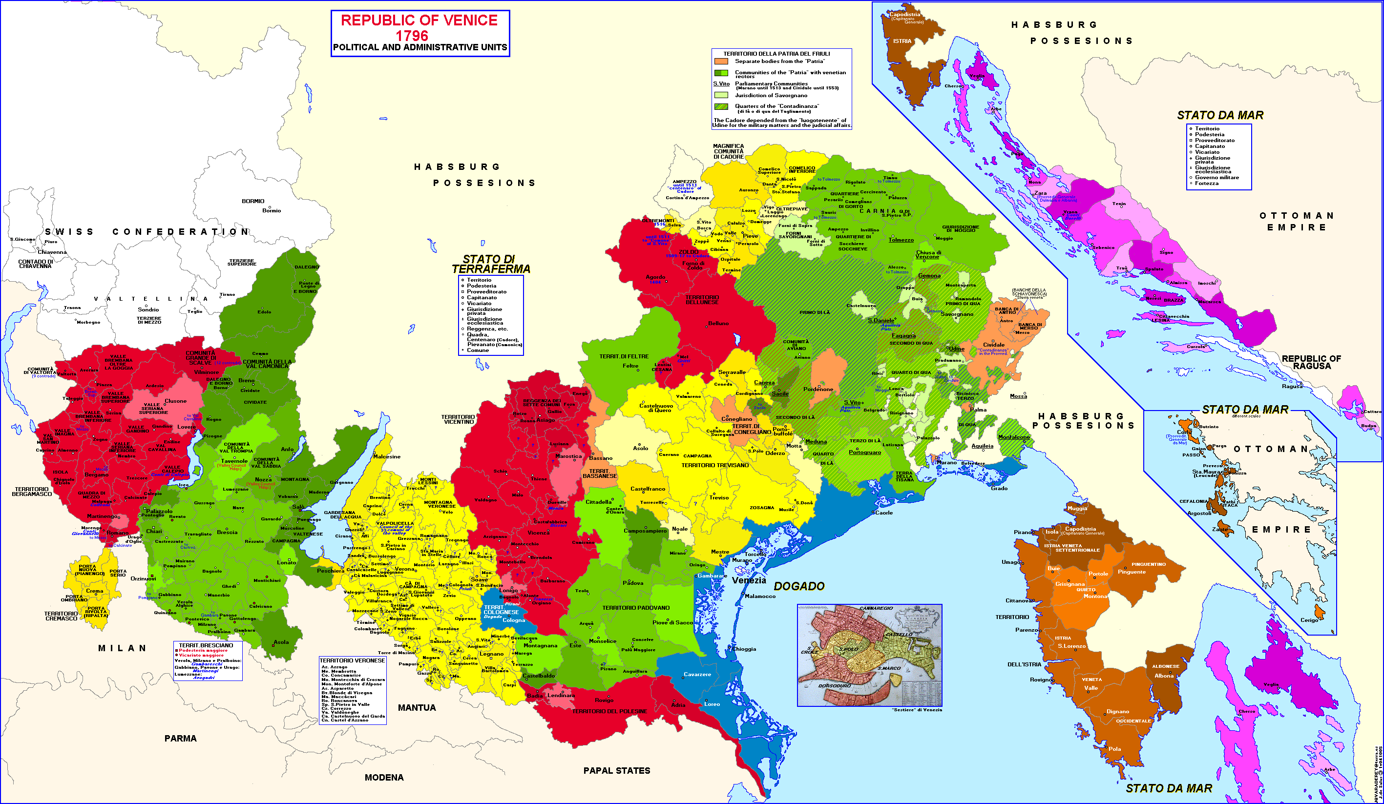
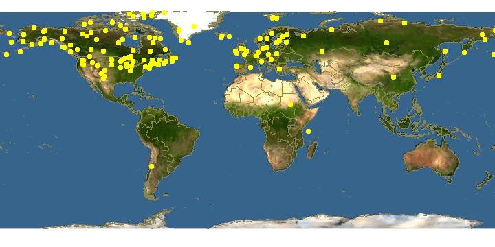
.jpg&action=edit&redlink=1)
_zh.svg)
_zh.svg)
.svg)
.svg)
.svg)
- Article(s)
- MH370
- Request
- Simplified Chinese translations of the following maps requested:
Key for File:MH370 flight path with English labels.png:
- Malaysia Airlines Flight 370 Known Flight Path - 马航370航班的已知路径
- Source: Joint Investigation Team - 来源:联合调查组
- Departs KLIA 12:41 MYT (16:41 UTC) - 于12:41大马标准时间(协调世界时16:41)在吉隆坡国际机场出发
- Last ACARS message 1:06 MYT (17:06 UTC) - 最后飞机通信寻址与报告系统信息 (ACARS)于1:06大马标准时间(协调世界时 17:06)发出
- Last secondary radar contact 01:22 MYT (17:22 UTC) - 最后与二次雷达接触的大马标准时间为 01:22 (协调世界时 17:22)
- 200nm (370km/230mi) - 200海里 (370公里/230英里)
- Last primary radar contact 02:22 MYT (18:22 UTC) - 最后与一次雷达接触的大马标准时间为 02:22 (协调世界时 18:22)
- Andaman Sea - 安达曼海
- Nicobar Islands (India) - 尼科巴群岛 (印度)
- Indian Ocean - 印度洋
- Indonesia - 印尼
- Banda Aceh - 亚齐
- Medan - 棉兰
- Malaysia - 马来西亚
- Ipoh - 怡保
- Kuala Terengganu - 瓜拉登嘉楼
- Penang - 槟城
- Kuala Lumpur - 吉隆坡
- Singapore - 新加坡
- Thailand - 泰国
- Hat Yai - 合艾
- Vietnam - 越南
- Can Tho - 芹苴
- Ho Chi Minh City - 胡志明市
- Cambodia - 柬埔寨
- Gulf of Thailand - 泰国湾
- 10oN - 北纬10度
- 5oN - 北纬5度
- 0o - 赤道0度
Key for File:MH370 ATC and air routes map.png
- Malaysia Airlines Flight 370 Air Traffic Control and Air Routes - 马航370航班空管和空中航线
- FIR Ho Chi Minh - 胡志明市飞航情报区
- FIR Singapore - 新加坡飞航情报区
- FIR Bangkok - 曼谷飞航情报区
- FIR Kuala Lumpur - 吉隆坡飞航情报区
- Gulf of Thailand - 泰国湾飞航情报区
- South China Sea - 南中国海
- Malaysia - 马来西亚
- Kuala Terengganu - 瓜拉登嘉楼
- Kota Bharu - 哥打巴鲁
- Thailand - 泰国
- Narathiwat - 那拉提瓦
- Vietnam - 越南
- 105oE - 东经105度
- 7oN - 北纬7度
- ATC for routes M765 & R208 through FIR Singapore provided by Kuala Lumpur ACC - 通过新加坡飞航情报区M765和R208的空管航线是由吉隆坡区域管制中心所提供
- Disappears from secondary radar (1:21 MYT) - 从二次雷达中消失 (大马标准时间 1:21)
- Flight path - secondary radar - 二次雷达所探测到的飞行路径
- Flight path - military radar - 军用雷达所探测到的飞行路径
- Planned Flight Path - 原定飞行路径
- Flight Information Region (FIR) - 飞航情报区
- FIR Boundaries (includes international border) - 飞航情报区边界(包括国际边界)
- Air route (selected named) - 特定空中航线
- Navigational waypoint (selected) - 特定导航点
- International border (also forms FIR boundary) - 国际边界(也形成飞航情报区边界)
- 1. Source: MH370 - Definition of Underwater Search Areas Australian Transport Safety Bureau, June 2014, pg. 3 - 来源:《MH370 - 水下搜索区域的界定》,第3页, 由澳洲交通安全局于2014年6月发布。
- 2. Based on the flight path taken by MAS Flight 370 in several flights shortly before 8 March 2014. - 根据2014年3月8日前夕的MH370数次航班的飞行路径。
File:MH370 SIO search.png (Translation by User:Cerevisae):
   The Search for Malaysia Airlines Flight 370
   In the Southern Indian Ocean (through July 2015) - 搜寻马来西亚航空公司航班370
   在南印度洋(至2015年7日)
   104oE - 东经104度
   103o50' E - 东经103度50分
   45oS - 南纬45度 (and so on)
   Elevation (metres) - 海拔(米)
   7th BTO arc - Location (distance from satellite) of Flight 370 at the time of its last transmission (8:19 MYT / 00:19 UTC, 8 March 2014) - 第七突发时序偏移弧 - 370航班的位置(与卫星的距离)(break)在当时的最后一次发送的时间 (break)(大马标准时间 8:19/协调世界时 00:19,2014年3月8日)
   Above sea level - 海拔(米)
   Cocos Is. (Australia) - 科科斯群島 (澳洲)
   Detected by sonobuoy - 由声纳浮标所检测
   Location (area of uncertainty) of an event detected by hydrophone stations about at 1:30 UTC, 8 March 2014 - 于2014年3月8日协调世界时 1:30(break)通过水听器站点所检测到的地点(不确定区)的有关事件
   Search areas 3-11 April 2014 - 4月3日至11日的搜索区域
   Search areas 12-28 April 2014 - 4月12日至28日的搜索领域
   Broken Ridge - 布罗肯海岭
   Search areas 28 March - 3 April 2014 - 3月28日至4月3日的搜索领域
   TPL search & seafloor sonar survey (inset) - 拖行声波定位器搜索和海底声呐调查(插图)
   Search areas 18 - 27 March 2014 - 3月18日至27日的搜索区域
   Australia - 澳洲
   Amsterdam Is. (France) - 阿姆斯特丹岛 (法国)
   Saint Paul Is. (France) - 圣保罗岛(法国)
   Perth Canyon (IMOS) - 珀斯峡谷 (综合海洋观测系统)
   Perth - 珀斯
   RAAF Base Perce - 澳大利亚皇家空军的皮尔斯基地
   Fremantle Harbour - 弗里曼特尔海港
   Cape Leeuwin - 露纹角
   HA01 (CTBTO) - 条约编号:HA01(全面核禁试条约组织)
   Note: Surface search areas (18 March - 28 April 2014) were influenced by ocean drift from possible impact location over intervening time (since 8 March 2014) - 注:水面搜索区域(2014年3月18日至4月28日)。(break) 该搜索区域是由可能的坠毁的位置(break)和海洋漂移所影响(自2014年3月8日)。
   Path of ADV Ocean Shield with Towed Pinger Locator (4-14 April) - 海洋之盾号与拖行声波定位器的路径(4月4日至14日)
   Acoustic detections - 声音检测器
   Max. effective detection range (3 km) - 最大有效检测范围(3公里)
   Seafloor sonar survey (14 April-28 May) - 海底声纳调查(4月14日至5月28日)
   Sources: Royal Australian Navy & Phoenix International - 资料来源:澳洲皇家海军与凤凰国际
   Flight path / impact area calculations - 飞行路线/坠毁面积计算
   18 March 2014 - 2014年3月18日
   28 March 2014 - 2014年3月28日
   3 April 2014 - 2014年4月3日
   Highest probability - 最高概率
   Medium probability - 中等概率
   Lowest probability - 最低概率
   October 2014 - 2014年10月
   Facilities used: - 设备使用:
   Port - 港口
   Airfield - 机场
   Underwater search: - 水下搜索:
   Sonobuoy deployments - 声纳浮标部署
   Hydrophone stations - 水听器站点
   Satellite images of possible debris: - 卫星图像所显示的可能碎片:
   Thaichote (24 March 2014) - 泰国地球观测卫星(2014年3月24日)
   Gaofen-1 (18 March 2014) - 高分一号卫星 (2014年3月18日)
   Airbus (23 March 2014) - 空客防务卫星(2014年3月23日)
   Digital Globe (16 March 2014) - 數位全球公司卫星(2014年3月16日)
   Priority search area - 60,000 km2 (began October 2014, largely complete by May 2015) - 优先搜索区域 - 60,000平方公里(始于2014年10月,2015年5月大致上完成)
   Expanded search area - 120,000km2 (approx. boundary, announced April 2015, began May 2015) - 扩大搜索范围 - 120,000平方公里(预计边界,于2015年4月宣布,开始于2015年5月)
   Wide area search - 1,120,000 km2 (identified, but no plans to search as of 31 July 2015) - 大范围搜索 - 1,120,000平方公里 (已确定,但截至于2015年7月31日,还没有计划要开始搜索)
   Sources: Australia Maritime Safety Authority & Australian Transport Safety Bureau - 资料来源:澳洲海事安全局和澳洲交通安全局
   Map by Andrew Heneen (December 2014, updated 31 July 2015), Licenced: CC-BY-3.0 - 地图来自Andrew Heneen(创作于2014年12月,更新于2015年7月31日),拥有“创作共用授权 - 署名 - 相同方式共享”条款的许可。
WhisperToMe (talk) 22:13, 11 August 2015 (UTC)
@WhisperToMe: Do you still want those translations, if so I can do it but I will have to make svg versions of the png files then. So let me know if you want them, thanks. --Goran tek-en (talk) 16:16, 24 July 2017 (UTC)
- @Goran tek-en: Yes please, I would still like to have the translations :) WhisperToMe (talk) 09:18, 1 August 2017 (UTC)
![]() Request taken by Goran tek-en (talk) 16:33, 1 August 2017 (UTC)
Request taken by Goran tek-en (talk) 16:33, 1 August 2017 (UTC)
@WhisperToMe: Now there is draft for you to look at. I'm missing some translations so please give them to me. Also when dividing on multiply lines I have no idea what I'm doing. Give me feedback, thanks. --Goran tek-en (talk) 19:27, 3 August 2017 (UTC)
- @Goran tek-en: Phuket is 普吉, 100oE - 东经100度, and 95oE - 东经95度. Need any others? WhisperToMe (talk) 14:33, 4 August 2017 (UTC)
- @WhisperToMe: New draft for you, you have to reload/update to get the new version. If you want the scale translated I need them also, feedback, thanks. --Goran tek-en (talk) 14:54, 4 August 2017 (UTC)
- @WhisperToMe: I really need your help and feedback to be able to complete your request, both right now and further on. --Goran tek-en (talk) 17:55, 10 August 2017 (UTC)
- @Goran tek-en: The draft looks great! I've been trying to find out if Chinese maps use "km" (like English ones do) or if they use a Chinese character, but my searches on Google and Baidu weren't conclusive. I'm going to ask on the ZH Wikipedia IRC channel WhisperToMe (talk) 17:25, 16 August 2017 (UTC)
- @Goran tek-en: On IRC techyan just told me there's no need to translate km/mi as Chinese speakers understand what that means - The map can proceed ... sorry for the wait! WhisperToMe (talk) 17:29, 16 August 2017 (UTC)
- Most Chinese speakers know what km means, and use it in daily basies. But many may have difficulties understanding mi. Since there are already translations of kilometers and miles in the graph, they could suggested the readers that the meaning of mi even if they don't know that accuartely. Plus, that is in a plotting scale, where most maps in China uses English abbreviations instead of Chiense words. --Techyan(Talk) 17:40, 16 August 2017 (UTC)
- @WhisperToMe: Now you can find it here file:MH370 flight path with labels-zh-s.svg.
- @Goran tek-en: The draft looks great! I've been trying to find out if Chinese maps use "km" (like English ones do) or if they use a Chinese character, but my searches on Google and Baidu weren't conclusive. I'm going to ask on the ZH Wikipedia IRC channel WhisperToMe (talk) 17:25, 16 August 2017 (UTC)
- @WhisperToMe: I really need your help and feedback to be able to complete your request, both right now and further on. --Goran tek-en (talk) 17:55, 10 August 2017 (UTC)
- @WhisperToMe: New draft for you, you have to reload/update to get the new version. If you want the scale translated I need them also, feedback, thanks. --Goran tek-en (talk) 14:54, 4 August 2017 (UTC)
The next is a png image MH370_ATC_and_air_routes_map so I had to make a svg version so it can be translated to other languages easier.
So before I do the Chinese version I want you to help me with checking my English svg version. Give me feedback on it so I can continue or change what ever needs, thanks. --Goran tek-en (talk) 21:03, 16 August 2017 (UTC)
- @Goran tek-en: Will the resolution be bigger? If not, I wonder if the text of footnotes 1 and 2 and the city text for Kuala Terengganu and Narathiwat could be made just slightly bigger for readability. Other than that it looks good :) WhisperToMe (talk) 21:08, 17 August 2017 (UTC)
- @WhisperToMe: I have increased the texts you mentioned but it's a svg so it can be enlarged without any quality lost.
- You can find it here file:MH370 ATC and air routes map-en.svg and I will work on the Chinese version now. --Goran tek-en (talk) 17:12, 18 August 2017 (UTC)
- @WhisperToMe: I tried to find out if simplified Chinese is written left to wright or the opposite when written horizontal. But the information I found tells me it can be either or. How should those translations be written, it's important in legend and other places? --Goran tek-en (talk) 16:37, 19 August 2017 (UTC)
- @Goran tek-en: In Mainland China Chinese is usually written left to right, or top to bottom. AFAIK it is written right to left only on airplanes or buses or ships (if viewing the starboard side) - If it's alright @Techyan: might elaborate more WhisperToMe (talk) 02:28, 20 August 2017 (UTC)
- @Goran tek-en and WhisperToMe: Left to right. Both simplified and traditional in modern days write this way. That's why the side bar zh.wikipedia.org and en.wikipedia.org are all to the left while ar.wikipedia.org is to the right. When writting vertically (from top to bottom) in modern Chinese, both from left to right and opposite is acceptable. Readers will try to figure out the text start from which side when they are reading vertical Chinese texts. In modern Japanese, vertical texts are prefer to write from right to left, while Chinese (regardless of simplified and traditional) have no preferences. --Techyan(Talk) 04:54, 20 August 2017 (UTC)
- @Techyan and WhisperToMe: Thanks for that information. Now there is a draft for you to check. There are some items I couldn't find translation for so I need them if it should be translated. Feedback, thanks. --Goran tek-en (talk) 14:46, 20 August 2017 (UTC)
- @Goran tek-en: - I took a look. IGARI and BITOD are names of waypoints and I don't think they need to be translated. @Techyan: . I don't think I see anything else that's not translated. WhisperToMe (talk) 23:48, 28 August 2017 (UTC)
- @WhisperToMe: All translated. No need to translate other texts. --Techyan(Talk) 04:55, 29 August 2017 (UTC)
- @Goran tek-en: - I took a look. IGARI and BITOD are names of waypoints and I don't think they need to be translated. @Techyan: . I don't think I see anything else that's not translated. WhisperToMe (talk) 23:48, 28 August 2017 (UTC)
- @Techyan and WhisperToMe: Thanks for that information. Now there is a draft for you to check. There are some items I couldn't find translation for so I need them if it should be translated. Feedback, thanks. --Goran tek-en (talk) 14:46, 20 August 2017 (UTC)
- @Goran tek-en and WhisperToMe: Left to right. Both simplified and traditional in modern days write this way. That's why the side bar zh.wikipedia.org and en.wikipedia.org are all to the left while ar.wikipedia.org is to the right. When writting vertically (from top to bottom) in modern Chinese, both from left to right and opposite is acceptable. Readers will try to figure out the text start from which side when they are reading vertical Chinese texts. In modern Japanese, vertical texts are prefer to write from right to left, while Chinese (regardless of simplified and traditional) have no preferences. --Techyan(Talk) 04:54, 20 August 2017 (UTC)
- @Goran tek-en: In Mainland China Chinese is usually written left to right, or top to bottom. AFAIK it is written right to left only on airplanes or buses or ships (if viewing the starboard side) - If it's alright @Techyan: might elaborate more WhisperToMe (talk) 02:28, 20 August 2017 (UTC)
- @WhisperToMe: I tried to find out if simplified Chinese is written left to wright or the opposite when written horizontal. But the information I found tells me it can be either or. How should those translations be written, it's important in legend and other places? --Goran tek-en (talk) 16:37, 19 August 2017 (UTC)
- @WhisperToMe: I have increased the texts you mentioned but it's a svg so it can be enlarged without any quality lost.
@WhisperToMe: Now you can find it here MH370 ATC and air routes map-zh-s.svg, I will work on the last one now. --Goran tek-en (talk) 17:59, 29 August 2017 (UTC)
@WhisperToMe: New draft of the third image. There are some texts that are not translated, upper left corner and Australia side. Also I had to make line breaks without knowing if it's correct so check everything.
This map is a true svg map based on this File:MH370_SIO_search_through_Nov_2014.svg which has a raster image in the background.
Feedback thanks. --Goran tek-en (talk) 19:41, 29 August 2017 (UTC)
- @Goran tek-en: Sorry for getting to this late. I took a look and the format looks fine. As for the one untranslated thing, I don't know how to say that. @Techyan: , how do you state:
- "Towed Pinger Locator Search & Seafloor Sonar Survey (4 April - 28 May 2014)" in Simplified Chinese? I believe the date part is "从2014年4月4日到28日".
- en:Exmouth UK has the Chinese article zh:埃克斯茅斯 so I wonder if Exmouth in Australia can use that name too. RAAF Base Amberley is "安伯利空军基地" but I don't know how Learmonth would be translated.
- Thanks :)
- WhisperToMe (talk) 22:10, 12 September 2017 (UTC)
- @WhisperToMe: The translations I found for "Towed Pinger Locator" vary on the internet, so I will ask for an exact translation in an aviation-related forum. It may take a couple of days to get an answer. --Techyan(Talk) 17:32, 13 September 2017 (UTC)
- @WhisperToMe: I am one of colleagues of Techyan on Chinese Wikipedia. I authored some civil aviation entries mostly on Chinese Wikipedia. I am an amateur of civil aviation as well. Hereby provides you translation aid which you need.
Towed Pinger Locator Search--拖拽式声波发射定位器搜索
Seafloor Sonar Survey--海底声纳勘测
Exmouth--埃克斯茅斯
RAAF Learmonth--澳大利亚皇家空军里尔蒙斯机场
Plus, I suggest you to ask a Chinese native (or people who are familiar with Chinese, near native) to polish your translation. For example, it is much better to translate TPL search & seafloorsonar survey (inset) into 拖拽式声波发射定位器搜索和海底声纳勘测(详见小地图), because it fits Chinese language custom better. Because I am rather busy these days, so it will be better if you could find another Chinese native to help you polish your translation, sorry. If it is hard for you to find one, you can ask me then. I would like to help you in that circumstance.
Nice to meet you here. If you need some more help these days or in the future, you can contact me via my user talk page, I will help you if I can.--ArthurLau1997 (talk) 16:38, 24 September 2017 (UTC)
- Arthur, nice to meet you too! I really appreciate your post :) - I'll go on ZHwiki and ask around to see if people are willing to further refine any translations. @Goran tek-en: WhisperToMe (talk) 20:42, 24 September 2017 (UTC)
- @WhisperToMe: I will wait until you tell what to change and which translation to use. --Goran tek-en (talk) 15:30, 25 September 2017 (UTC)
- @Goran tek-en: Ok. I'll wait and see if other ZHwiki users give additional insights. Otherwise pay attention to what User:ArthurLau1997 said. If nobody else comes I'll ask Arthur to take another look and make more suggestions. WhisperToMe (talk) 15:59, 25 September 2017 (UTC)
- @WhisperToMe: I haven't heard anything in a long time so I have now made changes as above and uploaded the file.
- Now you can find it here: file:MH370 SIO search-zh-s.svg
- @WhisperToMe: I haven't heard anything in a long time so I have now made changes as above and uploaded the file.
- @Goran tek-en: Ok. I'll wait and see if other ZHwiki users give additional insights. Otherwise pay attention to what User:ArthurLau1997 said. If nobody else comes I'll ask Arthur to take another look and make more suggestions. WhisperToMe (talk) 15:59, 25 September 2017 (UTC)
- @WhisperToMe: I am one of colleagues of Techyan on Chinese Wikipedia. I authored some civil aviation entries mostly on Chinese Wikipedia. I am an amateur of civil aviation as well. Hereby provides you translation aid which you need.
- @WhisperToMe: The translations I found for "Towed Pinger Locator" vary on the internet, so I will ask for an exact translation in an aviation-related forum. It may take a couple of days to get an answer. --Techyan(Talk) 17:32, 13 September 2017 (UTC)
![]() Done If you are happy with this please put the code
Done If you are happy with this please put the code {{section resolved|1=~~~~}} on this request so it can be archived, thanks. --Goran tek-en (talk) 19:56, 26 November 2017 (UTC)
- @Goran tek-en: Looks good to me! :This section was archived on a request by: WhisperToMe (talk) 21:10, 30 November 2017 (UTC)