Commons:Graphic Lab/Map workshop/Archive/2012
SVG version[edit]
-
 Províncias eclesiásticas do Brasil.
 -
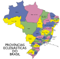 With names
(not finished) -
 Without names


Request:
SVG version of this map. Luan fala! 02:57, 16 December 2011 (UTC) ![]() Done on es-wiki
Done on es-wiki
- Place the names on the SVG version. House (talk) 21:09, 16 December 2011 (UTC)
- It may be better to number them then use the file description to hold the key (in different languages if necessary). --Fred the Oyster (talk) 22:03, 16 December 2011 (UTC)
Graphist opinion(s): What do the colour keys represent? --Fred the Oyster (talk) 22:02, 16 December 2011 (UTC)
 Request taken by Robot8A (talk). I'm putting names. --Robot8A (talk) 15:39, 18 December 2011 (UTC)
AutosoloCourses-AM-1&2.pdf[edit]
-
 Layout for autosolo event
 -
 SVG version

Request: Image looks like its over exposed, light lines, small and not really usefull as it is. If you guys think it can't be saved, please tag image to be deleted due to lack of educational value. Thanks folks! Hedwig in Washington (MAIL?) 01:23, 8 March 2012 (UTC)
Graphist opinion(s): I made the image clearer by making the stroke width 2px. I don't care this image deleted by consensus. Phoenix7777 (talk) 12:23, 8 March 2012 (UTC)
(Edit conflict) I extracted the artwork from the PDF container and increased the stroke values. Then converted to SVG. Unfortunately due to the way the original artwork was created it introduced a lot of inefficient path structures and accordingly increased the filesize exponentially. As PDF files can compress lineart and SVG can't the filesize increased from 23kb to 178kb. But at least it's viewable now (not that you'd believe it from the thumbnail!!. --Fred the Oyster (talk) 12:28, 8 March 2012 (UTC)
- Great! Thanks guys! You saved an image from the trash bin! :-))
- Which is all very well, but it doesn't appear to be being used for anything anyway, certainly not in any wiki articles. --Fred the Oyster (talk) 09:08, 12 March 2012 (UTC)
- Sorry for the delay, I just added a section on enwiki, if course including the image. :) I had a little backlog myself. --Hedwig in Washington (MAIL?) 17:27, 12 March 2012 (UTC)
![]() Done
Done
Adding new districts in Madhya Pradesh[edit]
-
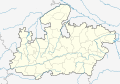 Blank location map of Madhya Pradesh
 -
 Smaller version of the other


Request: Correct the map according to [1]. Yann (talk) 05:57, 16 February 2012 (UTC)
- Could someone please help? This request is one year old. Yann (talk) 08:33, 22 February 2013 (UTC)
Graphist opinion(s):
I wonder if this map is appropiate, to.
I wonder if this map is appropiate, to. Please name the new districts. --maxxl2 ![]() - talk 12:31, 22 February 2013 (UTC)
- talk 12:31, 22 February 2013 (UTC)
- The names of the new districts are available on the link above. Or do you mean something else? Yann (talk) 15:54, 22 February 2013 (UTC)
- There is a new border between Guna and Ashoknagar, Sagar and Narsimhapur, Jhabua and Alirajpur, Khandwa and Burhanpur, Shahdol and Anuppur, Sindhi and Singrauli, Mandla extendsion to the east. In total there are 8 changes. Is that correct? --maxxl2
 - talk 11:09, 23 February 2013 (UTC)
- There is a new border between Guna and Ashoknagar, Sagar and Narsimhapur, Jhabua and Alirajpur, Khandwa and Burhanpur, Shahdol and Anuppur, Sindhi and Singrauli, Mandla extendsion to the east. In total there are 8 changes. Is that correct? --maxxl2
- List of districts of Madhya Pradesh says that there are 50 districts in M.P. However this map only shows 46 of them. The new districts are: Alirajpur District (split off Jhabua District), Singrauli District (split off Sidhi District), Burhanpur District (split off East Nimar), Ashoknagar (split off Guna). Thanks, Yann (talk) 19:07, 23 February 2013 (UTC)
- I hope its properly corrected now. --maxxl2 - talk 21:03, 23 February 2013 (UTC)
- Thanks a lot! Yann (talk) 06:43, 24 February 2013 (UTC)
- I hope its properly corrected now. --maxxl2
- List of districts of Madhya Pradesh says that there are 50 districts in M.P. However this map only shows 46 of them. The new districts are: Alirajpur District (split off Jhabua District), Singrauli District (split off Sidhi District), Burhanpur District (split off East Nimar), Ashoknagar (split off Guna). Thanks, Yann (talk) 19:07, 23 February 2013 (UTC)
- This section was archived on a request by: Yann (talk) 06:34, 24 February 2013 (UTC)
Habsburg[edit]

Request: English version please... Kintetsubuffalo (talk) 11:54, 7 March 2012 (UTC)
Graphist opinion(s):
- This section was archived on a request by: Kintetsubuffalo (talk) 11:06, 11 April 2013 (UTC)
Wilhelminapier update[edit]
-
 Map needs updating

Request: Hi, at about the place you see the orange stripe on the south bank there is an additional building, the New Orleans. On Open Street Maps it's the block that has the Lantaren/Venster theater in it. Thank you Vera (talk) 21:10, 15 March 2012 (UTC)
Graphist opinion(s):
![]() Done per [2] Phoenix7777 (talk) 08:39, 16 March 2012 (UTC)
Done per [2] Phoenix7777 (talk) 08:39, 16 March 2012 (UTC)
- The SVG seems to be a bit wobly :S --Vera (talk) 16:32, 16 March 2012 (UTC)
- Yes, strangely 120px and 200px didn't change, while 500px, 1000px, and 2000px changed correctly. I am not sure the cause of the problem. SVG Check shows fine. -- Phoenix7777 (talk) 22:20, 16 March 2012 (UTC)
- Those seem to be the old picture, if I download smaller versions through the top menu they just as wobly. --Vera (talk) 00:22, 17 March 2012 (UTC)
- Yes, strangely 120px and 200px didn't change, while 500px, 1000px, and 2000px changed correctly. I am not sure the cause of the problem. SVG Check shows fine. -- Phoenix7777 (talk) 22:20, 16 March 2012 (UTC)
I re-uploaded the file (plain SVG version). However the result is the same. I checked the http last-modified time of the png files.
- My upload time: 07:27 GMT, 20 March
- 120px: 10:30:12 GMT, 07 March
- 200px: 21:05:56 GMT, 15 March
- 500px: 07:33:40 GMT, 20 March
- 1000px: 07:39:53 GMT, 20 March
- 2000px: 07:40:51 GMT, 20 March
Clearly 120px and 200px are not updated to the new file. This seems to be some Squid cache management problem. ―― Phoenix7777 (talk) 07:57, 20 March 2012 (UTC)
Now two pngs are updated in MetaWiki server.
- 120px: 00:43:12 24 GMT, March
- 200px: 04:07:11 GMT, 25 March
- ―― Phoenix7777 (talk) 10:30, 26 March 2012 (UTC)
- I cropped the file --Vera (talk) 12:22, 21 April 2012 (UTC)
- This section was archived on a request by: Vera (talk) 12:22, 21 April 2012 (UTC)
Color correction[edit]
-
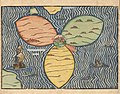
 Map of Asia Minor in 63 BCE

Request: The image has an unpleasant yellow shade, would it be possible to remove it? It was done in a similar image, this. --TcfkaPanairjdde (talk) 11:48, 24 April 2012 (UTC)
Graphist opinion(s): I fixed the white balance. However, the discoloration on the image is not completely uniform so now the top right is a bit blue-ish, while the bottom left is still yellowy Richardprins (talk) 21:40, 24 April 2012 (UTC)
- Let me thank you nonetheless. Bye.
- This section was archived on a request by: TcfkaPanairjdde (talk) 22:00, 24 April 2012 (UTC)
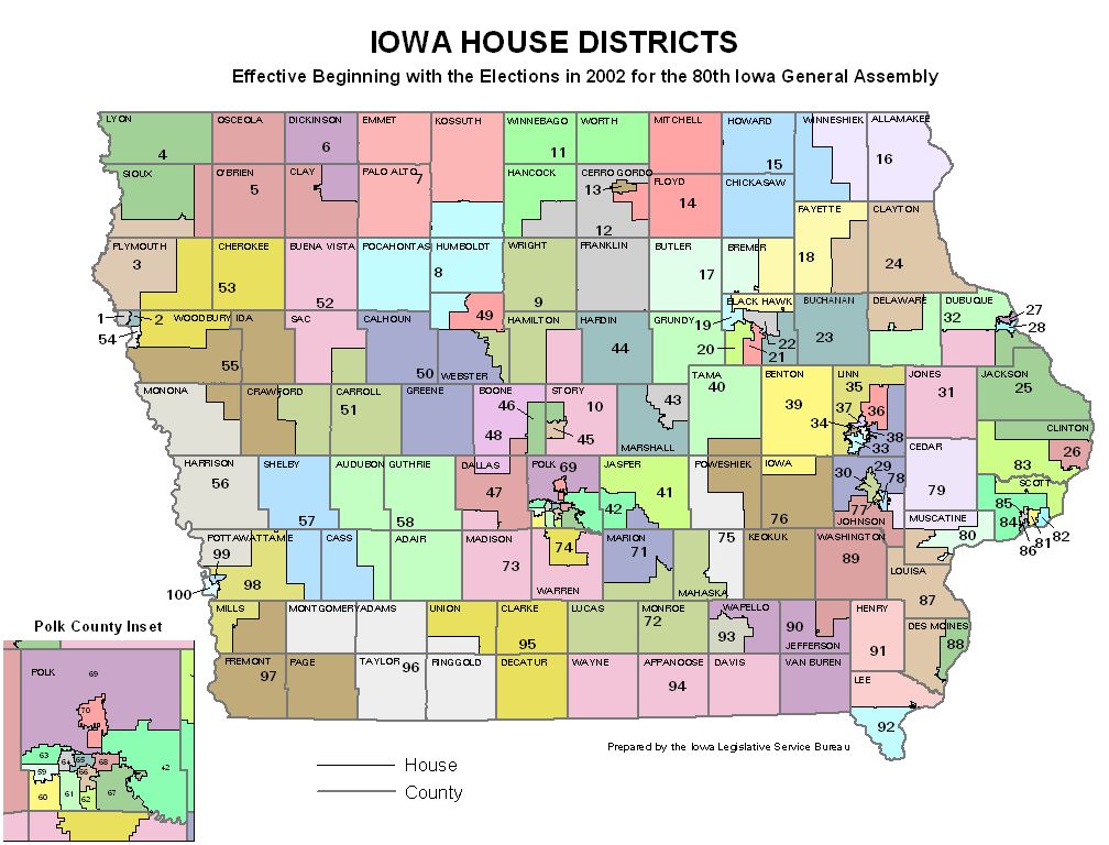
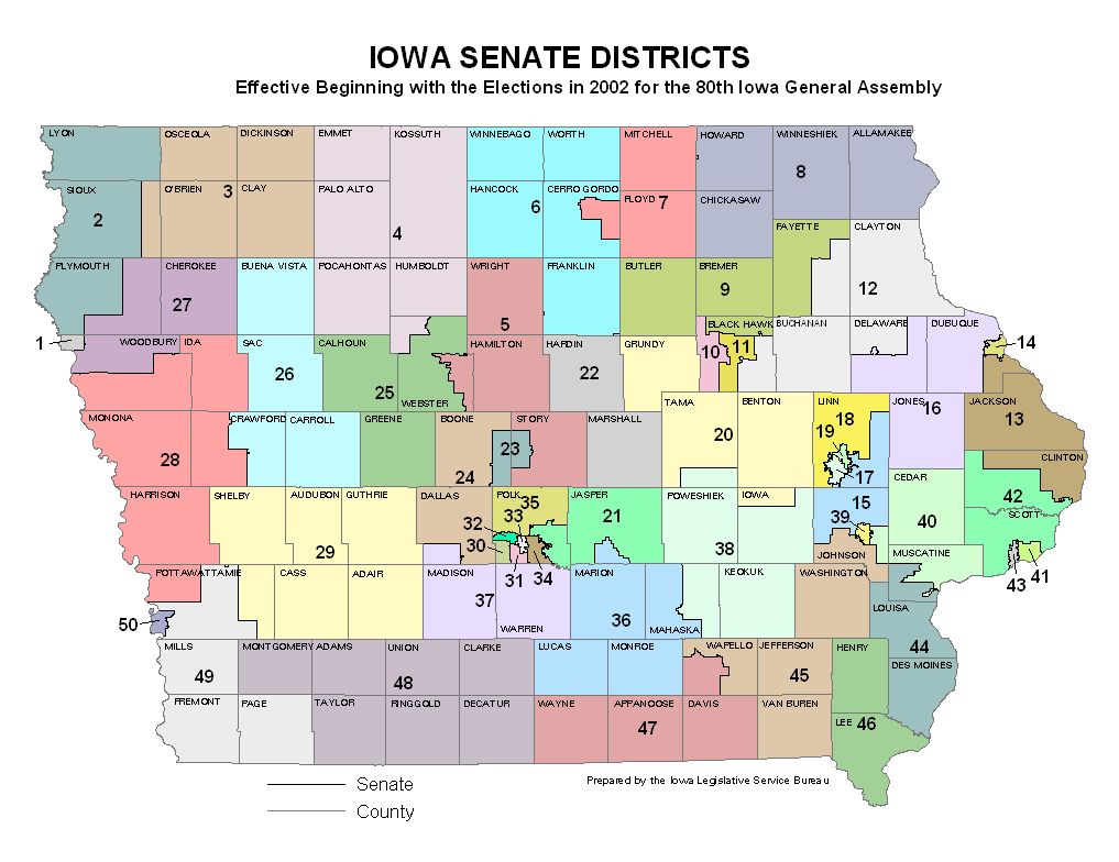
Add numbers to blank maps[edit]
-
 State House. District #s at https://www.legis.iowa.gov/DOCS/DistrictMaps/2003/House/house-color.jpg
 -
 State Senate. District #s at https://www.legis.iowa.gov/DOCS/DistrictMaps/2003/Senate/senate-color.jpg


Request: Would someone please add the district numbers to these blank maps? Thanks. --Philosopher Let us reason together. 07:19, 15 July 2012 (UTC)
- I suppose I should have noted that the districts are already sorted by district number order, they just need the numbers added to them. --Philosopher Let us reason together. 23:25, 17 July 2012 (UTC)
Graphist opinion(s): Never mind, I've figured it out. --Philosopher Let us reason together. 06:39, 18 July 2012 (UTC)
- This section was archived on a request by: Philosopher Let us reason together. 06:39, 18 July 2012 (UTC)
Creation of File:Tibet Mongolia Locator.svg[edit]


Request: Could any one create File:Tibet Mongolia Locator.svg as File:India Mongolia Locator.svg? Tibet isn't marked on the world map but can be found here : File:Tibet 1940.png. (I am creating fr:Relations entre le Tibet et la Mongolie).--Rédacteur Tibet (talk) 19:43, 6 December 2012 (UTC)
Graphist opinion:
Like this ? Penyulap ☏ 21:29, 3 January 2013 (UTC)
- older borders per talkpage request. Penyulap ☏ 16:53, 6 January 2013 (UTC)
- This section was archived on a request by: Patrick87 (talk) 11:13, 15 July 2013 (UTC)
Discrimination against atheists[edit]

Request: Can someone make a new version of this map that will have highlighted Arkansas, Maryland, Mississippi, South Carolina, Tennessee, Texas as US states in which atheists have reduced rights under law-- Bojan Talk 09:16, 14 December 2012 (UTC)
Graphist opinion(s):
- What exactly are the reduced rights, if I may ask? Powers (talk) 16:45, 16 December 2012 (UTC)
- According to w:Discrimination against atheists their state constitutions prohibit atheists from holding office, atheists don't actually have reduced rights though as they've been overturned by the Supreme Court (explicitly for Maryland, implied for the others). Kmusser (talk) 04:09, 17 December 2012 (UTC)
- I'm aware of that, but I thought Bojan might have something else in mind, something that actually materially affected atheists' rights in those states. If not, then I would recommend this request be rejected as contrary to our educational mission. Powers (talk) 20:30, 17 December 2012 (UTC)
- According to w:Discrimination against atheists their state constitutions prohibit atheists from holding office, atheists don't actually have reduced rights though as they've been overturned by the Supreme Court (explicitly for Maryland, implied for the others). Kmusser (talk) 04:09, 17 December 2012 (UTC)
Like this ? I know little about the states of the USA, so you'll have to check it. Without text it can be added onto other language wiki's I can't recall offhand how you do little text dots of different colours for a written legend, but the help desk can tell you pretty fast. I can add text to a duplicate image though. Penyulap ☏ 21:06, 3 January 2013 (UTC)
- This section was archived on a request by: Patrick87 (talk) 11:13, 15 July 2013 (UTC)
Jerusalem 1581[edit]
-
 map of Jerusalem in 1581
 -


Request:Is it possible to create a blank version of this map?--باسم (talk) 18:29, 23 December 2012 (UTC)
Graphist opinion(s): Like this ? Penyulap ☏ 21:14, 4 January 2013 (UTC)
- Yes! Thank you very mutch--باسم (talk) 23:44, 4 January 2013 (UTC)
- You're welcome. Penyulap ☏ 20:32, 5 January 2013 (UTC)
- Yes! Thank you very mutch--باسم (talk) 23:44, 4 January 2013 (UTC)
- This section was archived on a request by: Patrick87 (talk) 11:13, 15 July 2013 (UTC)
Tasmanian town locator PortArthur.png[edit]
-
 Tasmanian town locator PortArthur
 -
 New image


![]() Done
Request: An editor requested a new map here. I happen to agree with this editor. I too found it difficult to separate land from sea which is not helped by the blue that surrounds Hobart. Perhaps the image could be converted to SVG at the same time? --Senra (talk) 13:21, 31 December 2012 (UTC)
Done
Request: An editor requested a new map here. I happen to agree with this editor. I too found it difficult to separate land from sea which is not helped by the blue that surrounds Hobart. Perhaps the image could be converted to SVG at the same time? --Senra (talk) 13:21, 31 December 2012 (UTC)
- I suggest the water be blue and the land be green. A different shade of green can be used to show Hobart, and different shades of green and blue can be used in the inset, if necessary, to distinguish it from the rest of the map. 68.79.93.151 20:07, 31 December 2012 (UTC)
- Agreed. Erm. Make it so! He he --Senra (talk) 21:08, 31 December 2012 (UTC)
- Great job. Thank you --Senra (talk) 12:27, 5 January 2013 (UTC)
Graphist opinion(s):
How about this ? any good ? you wouldn't want a space station floating over the top of it by any chance would you ? God I'm bored. Penyulap ☏ 20:31, 3 January 2013 (UTC)
- Thank you, and you're welcome. Penyulap ☏ 19:45, 5 January 2013 (UTC)
- This section was archived on a request by: Patrick87 (talk) 11:13, 15 July 2013 (UTC)
Jerusalem 1581[edit]
-
map of Jerusalem in 1581
-
Request:Is it possible to create a blank version of this map?--باسم (talk) 18:29, 23 December 2012 (UTC)
Graphist opinion(s): Like this ? Penyulap ☏ 21:13, 4 January 2013 (UTC)
- This section was archived on a request by: Patrick87 (talk) 11:13, 15 July 2013 (UTC)
SVG corrections[edit]


Request: Please correct mistakes. On the first image: draw two districts and correct one word, on the second: remove municiplaity borders and correct three words (see tags on the images). Anatoliy (talk) 00:56, 13 January 2012 (UTC)
Graphist opinion(s):
![]() Done: By user:Texnik and user:DenysZ.--Anatoliy (talk) 15:29, 28 May 2012 (UTC)
Done: By user:Texnik and user:DenysZ.--Anatoliy (talk) 15:29, 28 May 2012 (UTC)
- This section was archived on a request by: Goran tek-en (talk) 18:05, 10 January 2014 (UTC)
Mistakes on the maps[edit]


Request: Please correct mistakes in words on maps. See tags on the images. Anatoliy (talk) 01:08, 13 January 2012 (UTC)
Graphist opinion(s): ![]() Done by user:Texnik and user:DenysZ
Done by user:Texnik and user:DenysZ
- This section was archived on a request by: Goran tek-en (talk) 18:04, 10 January 2014 (UTC)
Make "English" version of this map[edit]


'Request: Please make a second version of this map, where the decimal point commas (",") are replaced with periods/full stops (".") - The Spanish language uses commas as its decimal points, but the English language uses periods/full stops as its decimal points
Thank you WhisperToMe (talk) 05:06, 28 February 2012 (UTC)
 Done I made the raster image to a svg file for future maintenance. Phoenix7777 (talk) 13:17, 28 February 2012 (UTC)
- Thank you very much :) WhisperToMe (talk) 01:39, 11 September 2012 (UTC)
- This section was archived on a request by: Goran tek-en (talk) 17:59, 10 January 2014 (UTC)
Bosnie et Sandjak 1904.svg[edit]

Request: There is a problem with the legend – strange black boxes. — Cheers, JackLee –talk– 18:29, 27 March 2012 (UTC)
- Inkscape users, see here: Help:SVG#Fonts -- πϵρήλιο ℗ 21:48, 29 March 2012 (UTC)
Graphist opinion(s):
![]() Done --Fulvio314 (talk) 20:43, 2 May 2013 (UTC)
Done --Fulvio314 (talk) 20:43, 2 May 2013 (UTC)
- This section was archived on a request by: Goran tek-en (talk) 17:58, 10 January 2014 (UTC)
Rework a location map[edit]
-
 Location map of Yasuni National Park in Ecuador cleaned.
 -
 Location map of Yasuni National Park and Huaorani region in Ecuador.
 -
 Location map of Yasuni National Park in Ecuador.


Request: There is no explanation of the significance of the two shaded areas in the first map which appears to be a copy of the second map shown. The Huaorani territory section could be removed so that is a map solely of the National Park and a separate map could be made to incorporated that area. Also, the inset showing the Galapagos Islands is not needed in this context. Country names should also be used on the map. Alan Liefting (talk) 21:20, 29 March 2012 (UTC)
Graphist opinion(s):
![]() Done -- Fulvio 314 18:51, 14 May 2013 (UTC)
Done -- Fulvio 314 18:51, 14 May 2013 (UTC)
- This section was archived on a request by: Goran tek-en (talk) 17:57, 10 January 2014 (UTC)
Blank map of Europe cropped.svg with small circles[edit]
-
 Blank map of Europe

Request: Can you put on this map the circles for small countries in this way, each with its ISO-3116-1-ALPHA2 code in lower case for easy coloring?--Carnby (talk) 11:07, 5 April 2012 (UTC)
Graphist opinion(s):
![]() Done --Fulvio314 (talk) 21:09, 2 May 2013 (UTC)
Done --Fulvio314 (talk) 21:09, 2 May 2013 (UTC)
- This section was archived on a request by: Goran tek-en (talk) 17:42, 10 January 2014 (UTC)
Software suggestions[edit]
Not really a request. Could someone make a list of software useful to create/edit maps(SVG preferred). This section is not well documented in the main GL page. A short description of each software with pros and cons would be appreciated.--Gauravjuvekar (talk) 10:34, 10 April 2012 (UTC)
- I am not sure if your request is specific to Maps, but in the mean time, this might be of help en:Comparison of vector graphics editors --Jayarathina (talk) 11:04, 5 December 2012 (UTC)
- This section was archived on a request by: Goran tek-en (talk) 17:41, 10 January 2014 (UTC)
Archdioceses of Church of England (map)TRANSFERRED from Illustration workshop[edit]
-
 Map showing the two dioceses of the Church of England

Request: Also, a slightly different file exists on the English Wikipedia. Please can you convert this to an .svg file, making the background transparent, and upload it to Commons (the slightly different png file has been flagged for transfer on en). --000peter (talk) 13:43, 11 April 2012 (UTC)
Graphist opinion(s): You may get a better response if you place this request in the Map Workshop, rather than here. --Fred the Oyster (talk) 15:56, 11 April 2012 (UTC)
I created this map [3] (created with a ShareMap - take a look and opinions. --Jkan997 (talk) 22:39, 24 April 2012 (UTC)
- You need to double check your spellings. --Fred the Oyster (talk) 08:45, 25 April 2012 (UTC)
![]() Done
I checked spellings, map was created with ShareMap
Done
I checked spellings, map was created with ShareMap

--Jkan997 (talk) 23:35, 26 April 2012 (UTC)
- Leicester, Worcester and Gloucester are all spelt wrong, the outline of the UK is somewhat, errr, inexact and some of the labels need wrapping. I suggest that ShareMap may not be the best way of going about this. Perhaps you would end up with a better result by using one of the UK locator SVG maps here at Commons, eg Category:SVG locator maps of ceremonial counties in England (dark sea location map scheme), then labelling and shading that. --Fred the Oyster (talk) 18:20, 27 April 2012 (UTC)
--Thanks for comments - I fixed mispellings. The Britain map I used was Natural Earth 1:50M. In the free time I will replace it with Natural Earth 1:10M. --Jkan997 (talk) 19:59, 27 April 2012 (UTC)
--UK coastline was replaced to more precise (from NE 1:50M to NE 1:10M ) - thanks Fred the Oyster for mentioning this problem.
--Jkan997 (talk) 11:49, 12 May 2012 (UTC)
- This section was archived on a request by: Goran tek-en (talk) 17:40, 10 January 2014 (UTC)
Asia Minor 188 BCE[edit]
-
 Map of Asia Minor in 188 BCE

Request: The image is rather dark, is it possible do do something? --TcfkaPanairjdde (talk) 17:05, 26 April 2012 (UTC)
Graphist opinion(s): Like this? Yann (talk) 17:31, 26 April 2012 (UTC)
- Better, thanks. However it is a little too much yellow, is it possible to "move" towards white? Thanks. --TcfkaPanairjdde (talk) 16:43, 27 April 2012 (UTC)
Well, user appears to be gone, but colours have been adjusted to less yellow. I hope it's satisfactory. Nelg (talk) 01:17, 6 January 2013 (UTC)
- This section was archived on a request by: Goran tek-en (talk) 17:40, 10 January 2014 (UTC)
-
 Rio Pact locator map

Request: The locator map for the Rio Pact needs to be updated now that Bolivia, Ecuador, Nicaragua, and Venezuela announced their departure from the treaty last week. Thanks! Dominic (talk) 06:18, 12 June 2012 (UTC)
Graphist opinion(s):
![]() Already done: by User:Merchancano. --Philosopher Let us reason together. 07:32, 1 August 2012 (UTC)
Already done: by User:Merchancano. --Philosopher Let us reason together. 07:32, 1 August 2012 (UTC)
- This section was archived on a request by: Goran tek-en (talk) 17:38, 10 January 2014 (UTC)
India with cross.svg[edit]
-

DistortedCorrected -
 Sample


Request: The map of India in the image File:India with cross.svg is distorted and needs correction. Map in File:India roadway map.svg may be used as sample. §§AnimeshKulkarni (talk) 12:08, 28 June 2012 (UTC)
- It looks okay to me; it's probably just a different map projection. Powers (talk) 20:49, 30 June 2012 (UTC)
- Really? Check this sample. §§AnimeshKulkarni (talk) 16:02, 1 July 2012 (UTC)
Graphist opinion(s):
![]() Done It is distorted because it was created from a Pseudocylindrical projection map (File:Location India.svg). ―― Phoenix7777 (talk) 04:17, 2 July 2012 (UTC)
Done It is distorted because it was created from a Pseudocylindrical projection map (File:Location India.svg). ―― Phoenix7777 (talk) 04:17, 2 July 2012 (UTC)
- Oh i see! Thanks! §§AnimeshKulkarni (talk) 16:24, 2 July 2012 (UTC)
- This section was archived on a request by: Goran tek-en (talk) 17:37, 10 January 2014 (UTC)
Regionale Naturparks in Frankreich[edit]
-
 Die Karte der Regionalen Naturparks

Request: Die Karte der Regionalen Naturparks File:Parcs naturels français.svg ist nicht mehr aktuell. Zwischenzeitlich sind 2 neue Parks dazugekommen (PN des Ardennes und PN des Préalpes d'Azur). Bitte um Aktualisierung! --Skipper69 (talk) 12:02, 30 July 2012 (UTC)
Graphist opinion(s):
![]() Done Bourrichon (talk) 15:36, 8 August 2012 (UTC)
Done Bourrichon (talk) 15:36, 8 August 2012 (UTC)
- This section was archived on a request by: Goran tek-en (talk) 17:37, 10 January 2014 (UTC)
Chinese national highway map[edit]
-
Map of Chinese highways
Request: Remove the Chinese Wikipedia logo which is watermarked all over the map. --King of ♥ ♦ ♣ ♠ 17:00, 9 August 2012 (UTC)
Graphist opinion(s):
![]() Done: ―― Phoenix7777 (talk) 11:46, 11 August 2012 (UTC)
Done: ―― Phoenix7777 (talk) 11:46, 11 August 2012 (UTC)
- This section was archived on a request by: Goran tek-en (talk) 17:36, 10 January 2014 (UTC)
No sub after PNG rendering[edit]
-
 Monoglyceride chemical structure

Request: Can somebody take a look there? The original SVG is ok but the PNG rendering doesn't seem to understand the <sub>s. --Gikü (talk) 15:31, 21 August 2012 (UTC)
- Manage to work it out by byself. --Gikü (talk) 11:50, 29 August 2012 (UTC)
- This section was archived on a request by: Goran tek-en (talk) 17:35, 10 January 2014 (UTC)
Graphist opinion(s):
White Area Erase on a Transparent Background-PNG File[edit]
-
 The logo I've created for my Self graphic making project about Turkey.
Request: But accidently, I did a mistake and saved the .png file without realizing it. You see a white area above Turkey map if you largen the picture. This is a .png file and I wish that white area to be erased while transparent background stays. I've tried to erase it with Inkscape and GIMP but the transparent background had gone. So can you erase that white area while you don't harm the transparent background, and it is a little urgent.
(talk) 20:15, 13 October, 2012 (UTC)
- This is not a map. You may be looking for Commons:Graphic Lab/Illustration workshop. Powers (talk) 14:10, 14 October 2012 (UTC)
- Oh, my bad, I am taking this section directly to the Illustration page. Thanks.

- Oh, my bad, I am taking this section directly to the Illustration page. Thanks.
(talk) 15:01, 15 October, 2012 (UTC)
- This section was archived on a request by: Goran tek-en (talk) 17:29, 10 January 2014 (UTC)
Spanish language map[edit]
-
 With Spanish legend
 -
 With no legend
 -
 English version as requested


Request: Please make an English version. The legends should say "Majority use of the term Castellano" and "Majority use of the term Español" --WhisperToMe (talk) 11:55, 16 October 2012 (UTC)
Graphist opinion(s):
![]() Done―― Phoenix7777 (talk) 08:50, 17 October 2012 (UTC)
Done―― Phoenix7777 (talk) 08:50, 17 October 2012 (UTC)
- Thank you :) WhisperToMe (talk) 18:36, 19 October 2012 (UTC)
- This section was archived on a request by: Goran tek-en (talk) 17:27, 10 January 2014 (UTC)
Numbered Map of Pskov Oblast.svg[edit]
-
 Numbered Map of Pskov Oblast

Request: Do something with them...I just created this svg file as a derivative, but somehow the right side moved down by several pixels (above, there is a free space, and below, it is outside the frame). I have absolutely no idea what went wrong. If this is easy to correct, I'd appreciate it very much. If it takes more than five minutes, do not bother. Thanks in advance. --Ymblanter (talk) 14:55, 21 October 2012 (UTC)
Graphist opinion(s):
![]() Done You just moved all elements a bit. Please name the author of the original file. This is part of the license. NNW (talk) 15:42, 21 October 2012 (UTC)
Done You just moved all elements a bit. Please name the author of the original file. This is part of the license. NNW (talk) 15:42, 21 October 2012 (UTC)
- Great, thanks. Will add the original author now.--Ymblanter (talk) 16:11, 21 October 2012 (UTC)
- This section was archived on a request by: Goran tek-en (talk) 17:26, 10 January 2014 (UTC)
Map of Countries that do not recognize Christmas as Public Holiday[edit]

Request: In response to an edit request at en.wp., I wonder if this map could be updated to remove the brown shading from Nepal, where Christmas is now apparently a public holiday. Thanks. Rivertorch (talk) 05:44, 20 November 2012 (UTC)
Graphist opinion(s):
![]() Done ―― Phoenix7777 (talk) 09:03, 20 November 2012 (UTC)
Done ―― Phoenix7777 (talk) 09:03, 20 November 2012 (UTC)
- This section was archived on a request by: Goran tek-en (talk) 17:26, 10 January 2014 (UTC)
Map inaccuracies[edit]
-
 Distribution map of Podiceps auritus (French text)
 -
 Distribution map of Podiceps auritus (English text)


Request: to correct inaccuracies in map (needs someone with svg editing ability):
- Does not breed in Ireland: please change Ireland from yellow to white
- Does not breed in NW Washington and SW British Columbia: please extend white up western coastal N America to Queen Charlotte Islands
- Does not winter in inland northern Italy and Switzerland: please remove orange blob there
- Does winter on British coasts: please add orange line round British coast
- Does winter on northern Adriatic Sea coasts: please add orange line to coast from Po Valley (NE Italy) to entire Croatian coast
- (Optional) Traditional formatting of maps puts the legend with breeding at top, wintering below: invert text and colour blobs on Legend
Thanks! - MPF (talk) 11:34, 17 December 2012 (UTC)
Moved from Commons:Graphic_Lab/Photography_workshop#Map_inaccuracies ([4])--Hic et nunc (talk) 02:10, 19 December 2012 (UTC)
Graphist opinion(s):
![]() Done--maxxl2
Done--maxxl2 ![]() - talk 17:11, 26 February 2013 (UTC)
- talk 17:11, 26 February 2013 (UTC)
- This section was archived on a request by: Goran tek-en (talk) 17:25, 10 January 2014 (UTC)
Text Erasing Without Damaging The Transparent Background[edit]
-

-
 derived from File:Clickable_Regions_of_Ghana.svg

Request: I want the "Greater Accra" part and the line that shows the name to be deleted without harming the transparent background. And this is a little urgent, please. --Berkaysnklf (talk) 14:43, 22 December 2012 (UTC)
Graphist opinion(s):
- What is the source of this image? It says "own work" but you must have gotten the borders from somewhere. Powers (talk) 17:33, 22 December 2012 (UTC)
- I directly uploaded it, I will want image to be deleted after it is corrected and upload the one showing the election results, with the source. But here. --Berkaysnklf (talk) 16:37, 22 December 2012 (UTC)
- Hmm, have you read our licensing policy? The file File:Clickable_Regions_of_Ghana.svg is licensed under a Creative Commons Attribution-Share Alike license, which means that any works based on it (like your blank map) have to be licensed the same way, and the original author has to be credited. You claim "own work", instead of crediting User:Thfc, which makes it a copyright violation. I suggest updating the image description page, lest it be deleted. Furthermore, the original file is an SVG, a vector image format. Is there a reason your map is a PNG? It would be much easier to just modify the SVG, and it will produce better results. Powers (talk) 21:36, 24 December 2012 (UTC)
- I've gone ahead and created a blank SVG map based on the file you mentioned. If you need a PNG for some reason, you can generate one using the links underneath the image on the image description page. Powers (talk) 21:45, 24 December 2012 (UTC)
- I know the policies, I thought it will take about an hour so I uploaded it and wrote "Going to be improved." in description. But it took 2 days. Now I will choose the .PNG one and change its description by giving the needed attributions and will upload it same way after I finish the election map. Thanks a lot ! --Berkaysnklf (talk) 16:11, 25 December 2012 (UTC)
- I've gone ahead and created a blank SVG map based on the file you mentioned. If you need a PNG for some reason, you can generate one using the links underneath the image on the image description page. Powers (talk) 21:45, 24 December 2012 (UTC)
- Hmm, have you read our licensing policy? The file File:Clickable_Regions_of_Ghana.svg is licensed under a Creative Commons Attribution-Share Alike license, which means that any works based on it (like your blank map) have to be licensed the same way, and the original author has to be credited. You claim "own work", instead of crediting User:Thfc, which makes it a copyright violation. I suggest updating the image description page, lest it be deleted. Furthermore, the original file is an SVG, a vector image format. Is there a reason your map is a PNG? It would be much easier to just modify the SVG, and it will produce better results. Powers (talk) 21:36, 24 December 2012 (UTC)
- I directly uploaded it, I will want image to be deleted after it is corrected and upload the one showing the election results, with the source. But here. --Berkaysnklf (talk) 16:37, 22 December 2012 (UTC)
- This section was archived on a request by: Goran tek-en (talk) 17:24, 10 January 2014 (UTC)
Map of Countries that do not recognize Christmas as Public Holiday[edit]
Can the state of Laos (the inland country between Thailand and Vietnam) please be shaded brown since it does NOT recognise Christmas as a holiday? It is shaded grey in the map here which is wrong.
- Secondly, can Togo in Central Africa be shaded grey because it does have Christmas as a public holiday There are 2 independent web sources here. Thank You, --Leoboudv (talk) 05:13, 26 December 2012 (UTC)
Graphist opinion(s):
![]() Done―― Phoenix7777 (talk) 00:31, 28 December 2012 (UTC)
Done―― Phoenix7777 (talk) 00:31, 28 December 2012 (UTC)
 Comment: Thank you for your help Phoenix777.
- I have one final request. Can this map be slightly updated with the political boundaries of a new country? It is missing the new nation of South Sudan which was created in 2011 from Sudan in North Africa. The colour remains the same--grey as this list indicates as black South Sudan celebrates Christmas as a holiday--as does Arab North Sudan. If you can, that would be great. If not, then thank you for all your help. Best Regards, --Leoboudv (talk) 01:15, 28 December 2012 (UTC)
- Done―― Phoenix7777 (talk) 03:37, 28 December 2012 (UTC)
- Thank you very much and please have a Happy New Year Phoenix7777. Best Wishes from Vancouver, Canada, --Leoboudv (talk) 03:51, 28 December 2012 (UTC)
- This section was archived on a request by: Goran tek-en (talk) 17:22, 10 January 2014 (UTC)
Physical maps of Madhya Pradesh and Gujarat[edit]


Request: Create physical maps of Madhya Pradesh and Gujarat. Sources: [5], [6]. Yann (talk) 14:25, 13 February 2012 (UTC)
- Could someone please help? This request is one year old. Yann (talk) 08:33, 22 February 2013 (UTC)
Graphist opinion(s):
![]() Request taken by Goran tek-en (talk) 19:45, 12 January 2014 (UTC)
Request taken by Goran tek-en (talk) 19:45, 12 January 2014 (UTC)
What do you mean by physical map? --Goran tek-en (talk) 19:45, 12 January 2014 (UTC)
- Have a look at this draft here and give me feedback if this is what you are looking fore? --Goran tek-en (talk) 13:11, 13 January 2014 (UTC)
@Yann: I need your feedback as above if you want me to be able to complete your request, thanks. --Goran tek-en (talk) 17:06, 17 January 2014 (UTC)
- Yes, it looks good. I don't know how much details you can add, but do as best as you can. Thanks, Yann (talk) 02:11, 25 January 2014 (UTC)
- @Yann: Now they are uploaded and you can find them here;
- You should check the categories, description and so on, thanks. --Goran tek-en (talk) 18:58, 25 January 2014 (UTC)
- Thanks a lot! Great works. Yann (talk) 19:06, 25 January 2014 (UTC)
- Yes, it looks good. I don't know how much details you can add, but do as best as you can. Thanks, Yann (talk) 02:11, 25 January 2014 (UTC)
![]() Done
Done
- This section was archived on a request by: Goran tek-en (talk) 18:58, 25 January 2014 (UTC)
Updating a map[edit]


It seems like the English map is more up to date than the Spanish one. Please update the Spanish map to match the US map.
Also, please make the following changes on the Spanish map:
- Minneapolis -> Mineápolis
- St. Louis -> San Luis
- Los Angeles -> Los Ángeles
Thank you
WhisperToMe (talk) 17:46, 30 August 2012 (UTC)
@WhisperToMe: ![]() Done
Done
- This section was archived on a request by: Goran tek-en (talk) 18:48, 11 February 2014 (UTC)
Vectorize map[edit]
 From w:es:Wikiproyecto:Ilustración/Taller gráfico/Peticiones#Vectorizar MormonWarMap1.jpg
Please, if possible, vectorize the map and split it into layers, the text in one layer and the image in another layer. Regards!!! Ezarateesteban 13:26, 22 December 2012 (UTC)
From w:es:Wikiproyecto:Ilustración/Taller gráfico/Peticiones#Vectorizar MormonWarMap1.jpg
Please, if possible, vectorize the map and split it into layers, the text in one layer and the image in another layer. Regards!!! Ezarateesteban 13:26, 22 December 2012 (UTC)
- @Ezarate: Now you can have a look at a draft, takes time to load. I didn't add all the info on the map but if you want it just tell me. Give me feedback on this, thanks. --Goran tek-en (talk) 18:10, 13 February 2014 (UTC)
- Hi Goran. Translate this, the rests of texts put in English, pleas
- Grindstone Fork
- Adan-ondi-Ahman
- Mormon Missouri War, Northwestern Missouri in 1838Showing Points of conflict = Guerra Mormona de Missouri, Noroeste de Missouri en 1938, se visualizan los puntos en conflicto.
- Haun's Mill Massacre = Masacre del molino de Haun
- Battle of Crooked River = Batalla del Río Crooked
- Grand River = Río Grande
- Crooked River = Río Crooked
- Shoal Creek = Arroyo Shoal
- Missouri River = Río Missouri
Thanks!! Ezarateesteban 21:49, 17 February 2014 (UTC)
- OK Ezarate I didn't understand the two first lines as there was no translations.
- Is this Spanish?
- Now you can look at the two versions as I think we should upload both versions as it's now made in svg.
- Give me feedback, thanks. --Goran tek-en (talk) 10:31, 18 February 2014 (UTC)
- The first line haven't translation in English, could you please translate Far West = Lejano Oeste, thanks!!! Ezarateesteban 11:05, 18 February 2014 (UTC)
- Now the new version is up, spanish maybe you have to reload the page to get the new version.
- Is it Spanish?
- Is this Done now? --Goran tek-en (talk) 15:38, 18 February 2014 (UTC)
- Hunter's mill = Molino de Hunter, and ready!!! Thanks for your work!!!! Ezarateesteban 17:55, 18 February 2014 (UTC)
- OK Ezarate I didn't understand the two first lines as there was no translations.
Now you can find them here;
![]() Done --Goran tek-en (talk) 19:44, 18 February 2014 (UTC)
Done --Goran tek-en (talk) 19:44, 18 February 2014 (UTC)
- This section was archived on a request by: Goran tek-en (talk) 19:44, 18 February 2014 (UTC)
-
 California economic regions map
 -
 Blank map of Nevada
 -
 A guide?
.svg)


Request: I'm trying to make an image for w:Sacramento metropolitan area. The area in yellow on the California map has nearly every county but there's one in Nevada as well; w:Douglas County, Nevada. In the cluster of smaller counties on the middle left of Nevada, it is the bottom left one (hopefully that makes sense) and it should be labeled "Douglas" in the same font that's used on the California map. I think leaving the Sacramento Area yellow/golden would be fine, but if we could make the rest of the counties' labels go away and then cut out anything above Butte, below San Joaquin, and anything to the right (east) of a couple counties from Douglas that would be amazing (to limit scope to this area but give a small amount of context). If you have a better idea to try to do this that would look better, I'm open to suggestions. I tried doing this on Inkscape today but was very unsuccessful. :( --Killiondude (talk) 01:25, 29 April 2012 (UTC)
- How about the above PNG as a guide? I'd do it myself but I don't have any spare time at the minute. --Fred the Oyster (talk) 11:09, 29 April 2012 (UTC)
- As a guide for where Douglas County is, that's a good idea! Thanks for at least reading my request. :) Hopefully someone with enough time and graphic talent can piece this together. :) Killiondude (talk) 03:15, 2 May 2012 (UTC)
Graphist opinion(s): @Killiondude: Do you still want this map? If so contact me and I will do it, but probably will need your help along the way, thanks. --Goran tek-en (talk) 07:49, 4 April 2015 (UTC)
- This section was archived on a request by: Storkk (talk) 12:56, 5 August 2015 (UTC)
File:Europe polar stereographic Caucasus Urals boundary.svg[edit]

Request: Please add the borders of Morocco and Kosovo. --Liam987 (talk) 17:57, 1 August 2012 (UTC)
Graphist opinion(s):
![]() Request taken by Silvia eadt (talk): I'm working on it, i'll be finished in a few days. //
Request taken by Silvia eadt (talk): I'm working on it, i'll be finished in a few days. //
![]() Done: That's the best I can do editing the file with the programs I'm able to use, I added the borders but the definition of the image is in a lower detail now.
Done: That's the best I can do editing the file with the programs I'm able to use, I added the borders but the definition of the image is in a lower detail now.
- This section was archived on a request by: Storkk (talk) 12:56, 5 August 2015 (UTC)