Category:Maps of Delhi
Jump to navigation
Jump to search
States of India: Andhra Pradesh · Arunachal Pradesh · Assam · Bihar · Chhattisgarh · Goa · Gujarat · Haryana · Himachal Pradesh · Jharkhand · Karnataka · Kerala · Madhya Pradesh · Maharashtra · Manipur · Meghalaya · Mizoram · Nagaland · Odisha · Punjab · Rajasthan · Sikkim · Tamil Nadu · Telangana · Tripura · Uttar Pradesh · Uttarakhand · West Bengal
Union territories: Andaman and Nicobar Islands · Chandigarh · Dadra and Nagar Haveli and Daman and Diu · Delhi · Jammu and Kashmir · Ladakh · Lakshadweep · Puducherry
Former states of India: Jammu and Kashmir ·
Former union territories: Dadra and Nagar Haveli district · Daman and Diu ·
Union territories: Andaman and Nicobar Islands · Chandigarh · Dadra and Nagar Haveli and Daman and Diu · Delhi · Jammu and Kashmir · Ladakh · Lakshadweep · Puducherry
Former states of India: Jammu and Kashmir ·
Former union territories: Dadra and Nagar Haveli district · Daman and Diu ·
- 50 most populous urban areas of India
- Agra
- Ahmedabad
- Bangalore (Bengaluru)
- Bhopal
- Chandigarh
- Chennai (Madras)
- Coimbatore
- Delhi
- Gwalior
- Hyderabad
- Indore
- Jaipur
- Kannur (Cannanore)
- Kanpur
- Kochi (Cochin)
- Kolkata (Calcutta)
- Kollam (Quilon)
- Kozhikode (Calicut)
- Lucknow
- Madurai
- Malappuram
- Mumbai (Bombay)
- Nagpur
- Patna
- Pune (Poona)
- Srinagar
- Surat
- Thiruvananthapuram (Trivandrum)
- Thrissur (Trichur)
- Tiruchirappalli (Trichy)
- Varanasi (Banaras, Kashi)
- Vijayawada
- Visakhapatnam
Wikimedia category | |||||
| Upload media | |||||
| Instance of | |||||
|---|---|---|---|---|---|
| Category combines topics | |||||
| Delhi | |||||
Indian metropolis that includes New Delhi   someja satełitar in marso   _(claimed_and_disputed_hatched).svg)   | |||||
| Instance of |
| ||||
| Part of |
| ||||
| Location |
| ||||
| Head of government |
| ||||
| Has part(s) |
| ||||
| Inception |
| ||||
| Significant event |
| ||||
| Population |
| ||||
| Area |
| ||||
| Elevation above sea level |
| ||||
| Replaces |
| ||||
| Different from | |||||
| Said to be the same as | National Capital Territory of Delhi | ||||
 | |||||
Subcategories
This category has the following 11 subcategories, out of 11 total.
- Old maps of Delhi (35 F)
- Maps of the history of Delhi (17 F)
!
*
- Maps of New Delhi (4 F)
- Maps of Old Delhi (13 F)
B
- Blank maps of Delhi (3 F)
L
- Location maps of Delhi (1 F)
O
- OpenStreetMap maps of Delhi (10 F)
T
Media in category "Maps of Delhi"
The following 13 files are in this category, out of 13 total.
-
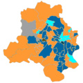 2013 Delhi assembly election.png 250 × 251; 38 KB
-
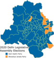 2020DelhiLegislativeAssemblyresult.png 450 × 478; 87 KB
-
 Administrative map of Delhi with RTO codes for vehicle registration.png 1,059 × 1,045; 143 KB
-
 Delhi districts.png 1,231 × 896; 1.01 MB
-
 Delhi map wikivoyage.png 7,557 × 8,102; 2.31 MB
-
 Delhi Parliamentary Constituencies.PNG 718 × 704; 85 KB
-
 DelhiAssembly2015.png 300 × 338; 48 KB
-
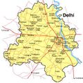 Delhimap.jpg 428 × 429; 46 KB
-
 DelhiMunicipalités.png 648 × 676; 32 KB
-
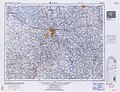 India and Pakistan 1-250000 NH 43-16 Delhi, 1962, LoC.jpg 8,598 × 6,566; 33.26 MB
-
 Karawal Nagar Delhi Assembly Constituency.jpg 700 × 702; 149 KB
-
 Majnu-ka-tilla.png 561 × 414; 151 KB
-
 Sarita Vihar.jpg 472 × 640; 105 KB


