Category:Maps of Cuyahoga Valley National Park
Jump to navigation
Jump to search
United States national parks: Acadia · American Samoa · Arches · Badlands · Big Bend · Biscayne · Black Canyon of the Gunnison · Bryce Canyon · Canyonlands · Capitol Reef · Carlsbad Caverns · Channel Islands · Congaree · Crater Lake · Cuyahoga Valley · Death Valley · Denali · Dry Tortugas · Everglades · Gateway Arch · Gates of the Arctic · Glacier · Glacier Bay · Grand Canyon · Grand Teton · Great Basin · Great Smoky Mountains · Guadalupe Mountains · Haleakalā · Hawaii Volcanoes · Hot Springs · Indiana Dunes · Isle Royale · Joshua Tree · Kenai Fjords · Kings Canyon · Kobuk Valley · Lake Clark · Lassen Volcanic · Mammoth Cave · Mesa Verde · Mount Rainier · North Cascades · Olympic · Petrified Forest · Pinnacles · Redwood · Rocky Mountain · Saguaro · Sequoia · Shenandoah · Theodore Roosevelt · Virgin Islands · Voyageurs · White Sands · Wind Cave · Wrangell-St. Elias · Yellowstone · Yosemite · Zion
English: Maps of Cuyahoga Valley National Park
Wikimedia category | |||||
| Upload media | |||||
| Instance of | |||||
|---|---|---|---|---|---|
| Category combines topics | |||||
| Cuyahoga Valley National Park | |||||
national park in Ohio, United States  | |||||
| Instance of | |||||
| Location |
| ||||
| Visitor center |
| ||||
| Operator | |||||
| IUCN protected areas category | |||||
| Inception |
| ||||
| Area |
| ||||
| Visitors per year |
| ||||
| official website | |||||
 | |||||
Subcategories
This category has only the following subcategory.
Media in category "Maps of Cuyahoga Valley National Park"
The following 51 files are in this category, out of 51 total.
-
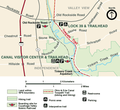 Canalvc.png 500 × 459; 73 KB
-
 Cuyahoga Valley National Park map of a portion of the canal route.jpg 5,312 × 2,988; 3.7 MB
-
 Cuyahoga Valley National Park.svg 1,000 × 1,000; 12 KB
-
 Cuyahoga Valley National Recreation Area, Ohio - park and area map LOC 95681528.jpg 10,276 × 7,206; 10.7 MB
-
 Cuyahoga Valley National Recreation Area, Ohio - park and area map LOC 95681528.tif 10,276 × 7,206; 211.86 MB
-
 Cuyahoga Valley National Recreation Area, Ohio - park and area map LOC 95681529.jpg 10,283 × 7,211; 12.2 MB
-
 Cuyahoga Valley National Recreation Area, Ohio - park and area map LOC 95681529.tif 10,283 × 7,211; 212.15 MB
-
 Cuyahoga Valley National Recreation Area, Ohio LOC 89694605.jpg 10,240 × 7,171; 10.96 MB
-
 Cuyahoga Valley National Recreation Area, Ohio LOC 89694605.tif 10,240 × 7,171; 210.09 MB
-
 Cuyahoga Valley National Recreation Area, Ohio LOC 89694606.jpg 10,285 × 7,188; 11.78 MB
-
 Cuyahoga Valley National Recreation Area, Ohio LOC 89694606.tif 10,285 × 7,188; 211.51 MB
-
 Cuyahoga Valley, official map and guide LOC 96681989.tif 10,258 × 7,188; 210.96 MB
-
 LocMap Cuyahoga National Park.png 280 × 183; 31 KB
-
 NPS cuyahoga-attractions-map.gif 1,700 × 2,540; 470 KB
-
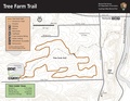
 NPS cuyahoga-tree-farm-trail-map.jpg 1,870 × 1,445; 657 KB
-
 NPS cuyahoga-tree-farm-trail-map.pdf 1,650 × 1,275; 495 KB
-
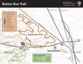
 NPS cuyahoga-valley-boston-run-trail-map.jpg 1,870 × 1,445; 741 KB
-
 NPS cuyahoga-valley-boston-run-trail-map.pdf 1,650 × 1,275, 2 pages; 2.93 MB
-
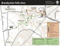
 NPS cuyahoga-valley-brandywine-falls-map.jpg 1,870 × 1,445; 900 KB
-
 NPS cuyahoga-valley-brandywine-falls-map.pdf 1,650 × 1,275; 980 KB
-
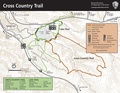
 NPS cuyahoga-valley-cross-country-trail-map.jpg 1,870 × 1,445; 1.01 MB
-
 NPS cuyahoga-valley-cross-country-trail-map.pdf 1,650 × 1,275; 763 KB
-
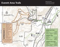
 NPS cuyahoga-valley-everett-area-trail-map.jpg 1,870 × 1,445; 912 KB
-
 NPS cuyahoga-valley-everett-area-trail-map.pdf 1,650 × 1,275; 994 KB
-
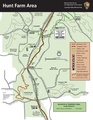
 NPS cuyahoga-valley-hunt-farm-trail-map.jpg 1,445 × 1,870; 451 KB
-
 NPS cuyahoga-valley-hunt-farm-trail-map.pdf 1,275 × 1,650; 1.1 MB
-
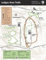
 NPS cuyahoga-valley-ledges-trail-map.jpg 1,445 × 1,870; 880 KB
-
 NPS cuyahoga-valley-ledges-trail-map.pdf 1,275 × 1,650; 493 KB
-
 NPS cuyahoga-valley-map-new.png 2,000 × 4,647; 2.69 MB
-
 NPS cuyahoga-valley-map.gif 1,427 × 3,284; 690 KB
-
 NPS cuyahoga-valley-map.pdf 1,427 × 3,283; 1.09 MB
-
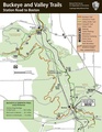
 NPS cuyahoga-valley-north-buckeye-trail-map.jpg 1,445 × 1,870; 444 KB
-
 NPS cuyahoga-valley-north-buckeye-trail-map.pdf 1,275 × 1,650; 484 KB
-
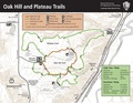
 NPS cuyahoga-valley-oak-hill-trail-map.jpg 1,870 × 1,445; 893 KB
-
 NPS cuyahoga-valley-oak-hill-trail-map.pdf 1,650 × 1,275; 685 KB
-
 NPS cuyahoga-valley-regional-map.gif 421 × 837; 39 KB
-
 NPS cuyahoga-valley-regional-map.pdf 314 × 627; 55 KB
-
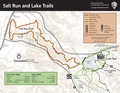
 NPS cuyahoga-valley-salt-run-trail-map.jpg 1,870 × 1,445; 978 KB
-
 NPS cuyahoga-valley-salt-run-trail-map.pdf 1,650 × 1,275; 872 KB
-
 NPS cuyahoga-valley-south-buckeye-trail-map.jpg 1,445 × 1,870; 485 KB
-
 NPS cuyahoga-valley-south-buckeye-trail-map.pdf 1,275 × 1,650; 448 KB
-
 NPS cuyahoga-valley-station-road-bridge-trail-map.jpg 1,445 × 1,870; 691 KB
-
 NPS cuyahoga-valley-station-road-bridge-trail-map.pdf 1,275 × 1,650; 998 KB
-
 NPS cuyahoga-valley-towpath-map.gif 450 × 4,140; 195 KB
-
 NPS cuyahoga-valley-towpath-map.pdf 375 × 3,450; 364 KB
-
 NPS cuyahoga-valley-towpath-trail-map.gif 1,502 × 3,218; 560 KB
-
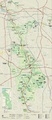
 NPS cuyahoga-valley-vegetation-map.gif 3,977 × 4,777; 1.79 MB
-
 NPS cuyahoga-valley-virginia-kendall-area-map.jpg 1,870 × 1,445; 323 KB
-
 NPS cuyahoga-valley-virginia-kendall-area-map.pdf 1,650 × 1,275; 1,019 KB
-
 NPS cuyahoga-valley-wetmore-trail-map.jpg 1,870 × 1,445; 1.01 MB
-
 NPS cuyahoga-valley-wetmore-trail-map.pdf 1,650 × 1,275; 1.01 MB


