Category:Geography of Mono County, California
Jump to navigation
Jump to search
Counties of California: Alameda · Alpine · Amador · Butte · Calaveras · Colusa · Contra Costa · Del Norte · El Dorado · Fresno · Glenn · Humboldt · Imperial · Inyo · Kern · Kings · Lake · Lassen · Los Angeles · Madera · Marin · Mariposa · Mendocino · Merced · Modoc · Mono · Monterey · Napa · Nevada · Orange · Placer · Plumas · Riverside · Sacramento · San Benito · San Bernardino · San Diego · San Joaquin · San Luis Obispo · San Mateo · Santa Barbara · Santa Clara · Santa Cruz · Shasta · Sierra · Siskiyou · Solano · Sonoma · Stanislaus ·Sutter · Tehama · Trinity · Tulare · Tuolumne · Ventura · Yolo · Yuba – Consolidated city-county: San Francisco
Wikimedia category | |||||
| Upload media | |||||
| Instance of | |||||
|---|---|---|---|---|---|
| Category combines topics | |||||
| Mono County | |||||
county in California, United States .jpg) Mono Lake as seen from Mount Dana     | |||||
| Instance of | |||||
| Named after | |||||
| Location | California, Pacific States Region | ||||
| Capital | |||||
| Inception |
| ||||
| Population |
| ||||
| Area |
| ||||
| official website | |||||
 | |||||
Subcategories
This category has the following 21 subcategories, out of 21 total.
A
- Adobe Hills (California) (3 F)
B
C
- Cascade Lake (California) (2 F)
- Conway Summit (29 F)
D
- Donohue Pass (24 F)
E
L
- Lee Vining Creek (1 P, 9 F)
M
- Mono Pass (6 F)
O
S
Media in category "Geography of Mono County, California"
The following 27 files are in this category, out of 27 total.
-
 California - Mono Lake - NARA - 543453.jpg 2,027 × 3,000; 1.02 MB
-
 California fish and game (19892243323).jpg 2,085 × 3,249; 250 KB
-
 Connes glacier.jpg 640 × 675; 143 KB
-
 Convict Lake Pano.jpg 3,600 × 1,240; 1.61 MB
-
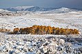 Early winter in the Bodie Hills 2017.jpg 2,048 × 1,365; 717 KB
-
 Extinct Volcano near Mono Lake, California - NARA - 519602.jpg 3,000 × 1,206; 1.16 MB
-
 Extinct Volcanoes. Near Mono Lake, California - NARA - 519497.jpg 3,000 × 2,253; 1.38 MB
-
 070617-6 Greenstone lake 10.jpg 3,872 × 2,592; 5.54 MB
-
 Glass-mountains.jpg 4,000 × 3,000; 1.6 MB
-
 Grennstone-lake.jpg 480 × 717; 90 KB
-
 Lee Vining aerial.jpeg 3,264 × 2,448; 2.74 MB
-
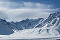
 Mammoth Lakes (Feb 2013) 05.JPG 3,801 × 2,590; 4.74 MB
-
 Mammoth Lakes (Feb 2013) 06.JPG 4,512 × 3,000; 6.87 MB
-
 Mammoth Yosemite Airport 11.JPG 4,333 × 2,167; 4.2 MB
-
 Mammoth Yosemite Airport 12.JPG 4,313 × 2,554; 5.05 MB
-
 Mammoth Yosemite Airport 16.JPG 4,370 × 2,094; 3.28 MB
-
 Mammoth-creek-glass-mountains.jpg 768 × 1,024; 93 KB
-
 McGee Creek valley from US395 winter.jpg 3,480 × 2,330; 3.03 MB
-

-

-
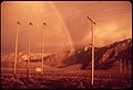 RAINBOW ABOVE POWER LINES NEAR MONO LAKE - NARA - 543130.jpg 3,000 × 2,050; 1.09 MB
-
 Sonora Pass - panoramio.jpg 3,372 × 2,248; 2.4 MB
-
 Sunrise light on Wheeler Crest frosted rocks.jpg 3,888 × 2,592; 3.89 MB
-
 Swall underhill near.jpg 3,504 × 2,336; 4.38 MB
-
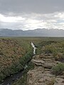
 W Walker River from Emigrant out to Leavitt Mdws.jpg 3,648 × 2,736; 5.65 MB
-
 Wheeler flatirons pastPinyons.jpg 3,504 × 2,336; 4.42 MB
-
 WhiteMtn-XmasSnow pastTrees.jpg 3,150 × 2,100; 3.22 MB

.jpg)


_05.JPG)
_06.JPG)


_NEAR..._-_NARA_-_543129.jpg)


