Category:Geography of Alameda County, California
Jump to navigation
Jump to search
Counties of California: Alameda · Alpine · Amador · Butte · Calaveras · Colusa · Contra Costa · Del Norte · El Dorado · Fresno · Glenn · Humboldt · Imperial · Inyo · Kern · Kings · Lake · Lassen · Los Angeles · Madera · Marin · Mariposa · Mendocino · Merced · Modoc · Mono · Monterey · Napa · Nevada · Orange · Placer · Plumas · Riverside · Sacramento · San Benito · San Bernardino · San Diego · San Joaquin · San Luis Obispo · San Mateo · Santa Barbara · Santa Clara · Santa Cruz · Shasta · Sierra · Siskiyou · Solano · Sonoma · Stanislaus ·Sutter · Tehama · Trinity · Tulare · Tuolumne · Ventura · Yolo · Yuba – Consolidated city-county: San Francisco
Wikimedia category | |||||
| Upload media | |||||
| Instance of | |||||
|---|---|---|---|---|---|
| Category combines topics | |||||
| Alameda County | |||||
county in California, United States       | |||||
| Instance of | |||||
| Part of |
| ||||
| Named after |
| ||||
| Location | California, Pacific States Region | ||||
| Capital | |||||
| Inception |
| ||||
| Population |
| ||||
| Area |
| ||||
| official website | |||||
 | |||||
| geography | |||||
science that studies the terrestrial surface, the societies that inhabit it and the territories, landscapes, places or regions that form it when interacting with each other     | |||||
| Pronunciation audio | |||||
| Instance of |
| ||||
| Different from | |||||
| Partially coincident with | |||||
| |||||
Subcategories
This category has the following 24 subcategories, out of 24 total.
A
- Mount Allison (1 P, 8 F)
- Arroyo del Valle (6 F)
B
C
D
- Lake Del Valle (9 F)
F
- Fleming Point (3 F)
K
- Kaiser Creek (6 F)
L
M
- Mission Peak (1 P, 64 F)
N
O
- Ohlone Wilderness Trail (10 F)
P
S
- San Antonio Reservoir (2 F)
Media in category "Geography of Alameda County, California"
The following 20 files are in this category, out of 20 total.
-
 131128 5456 - panoramio.jpg 3,560 × 2,848; 2.5 MB
-
 131128 5457 - panoramio.jpg 4,288 × 2,848; 2.1 MB
-
 131128 5459 - panoramio.jpg 2,848 × 4,288; 3.5 MB
-
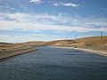 Bethany Reservoir and California Aqueduct.jpg 3,264 × 2,448; 2.63 MB
-

-
 Callahan Creek.jpg 3,024 × 4,032; 6.45 MB
-
 Cataracts on Kaiser Creek.png 874 × 1,474; 2.94 MB
-
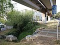 Cerrito Creek at Ohlone Greenway.jpg 4,592 × 3,448; 7.65 MB
-
 Del Valle Regional Park banner.jpg 7,736 × 1,228; 10.3 MB
-
 Del Valle Regional Park Panorama.jpg 8,596 × 2,362; 18.56 MB
-
 DoolanCanyon.jpg 4,592 × 3,448; 7.9 MB
-
 Emeryville mudflats distant San Francisco.JPG 3,240 × 2,406; 1.6 MB
-
 Flowers in the Wind (5498388389).jpg 1,279 × 616; 114 KB
-
 Kaiser Creek Canyon.png 2,880 × 1,800; 8.12 MB
-
 Kaiser Creek Cataract.png 1,372 × 1,800; 5.15 MB
-
 Kaiser Creek Waterfall.png 1,374 × 1,800; 5.15 MB
-
 Lake del Valle aerial view, December 2018.JPG 4,875 × 3,252; 2.17 MB
-
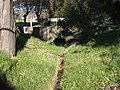 Marin Creek.jpg 2,560 × 1,920; 3.22 MB
-
 South from Rocky Ridge.png 2,880 × 1,800; 8.85 MB
-
 Upper San Leandro Creek.jpg 3,024 × 4,032; 7.68 MB


_(20260991129).jpg)


.jpg)


