Hărți despre România
(Redirected from Maps of Romania)
Countries of Europe: Albania · Andorra · Armenia‡ · Austria · Azerbaijan‡ · Belarus · Belgium · Bosnia and Herzegovina · Bulgaria · Croatia · Cyprus‡ · Czech Republic · Denmark · Estonia · Finland · France‡ · Georgia‡ · Germany · Greece · Hungary · Iceland · Republic of Ireland · Italy · Kazakhstan‡ · Latvia · Lithuania · Luxembourg · Malta · Monaco · Netherlands‡ · North Macedonia · Norway · Poland · Portugal‡ · Romania · Russia‡ · San Marino · Slovakia · Slovenia · Spain‡ · Sweden · Switzerland · Turkey‡ · Ukraine · United Kingdom · Vatican City
Specific status: Faroe Islands · Gibraltar · Isle of Man – Limited recognition: Abkhazia‡ · Kosovo
‡: partly located in Europe
Specific status: Faroe Islands · Gibraltar · Isle of Man – Limited recognition: Abkhazia‡ · Kosovo
‡: partly located in Europe
- Maps are also available as part of the
 Wikimedia Atlas of the World project in the Atlas of Romania.
-
 Satellite image of Romania in December 2001

Location Maps[edit]
-
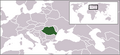 Location map for Romania
 -
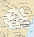 CIA map of Romania
 -
 CIA map with French caption
 -
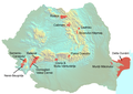 National Parks in Romania


Romanian Regions[edit]
-
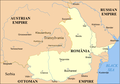
 Historical provincies of Greater Romania
 -
 Romania from 1859 - 1878


Romanian development regions[edit]
-
 Euro Regions of Romania
 -
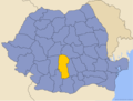
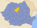
 Location of Centru development region
 -
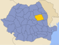
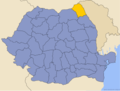
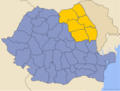 Location of Nord-Est development region
 -
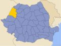
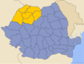 Location of Nord-Vest development region
 -
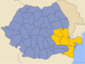
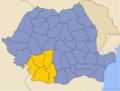
 Location of Sud development region
 -
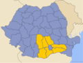
 Location of Sud-Est development region
 -
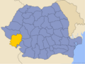
 Location of Sud-Vest development region
 -
 Location of Vest development region


Romanian counties[edit]
-
 Counties of Romania
 -
 Location of Alba county on a map of Romania
 -
 Location of Arad county on a map of Romania
 -
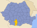
 Location of Argeş county on a map of Romania
 -
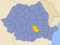
 Location of Bacău county on a map of Romania
 -
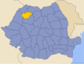
 Location of Bihor county on a map of Romania
 -
 Location of Bistriţa-Năsăud county on a map of Romania
 -
 Location of Botoşani county on a map of Romania
 -
 Location of Braşov county on a map of Romania
 -
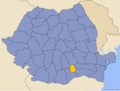
 Location of Braila county on a map of Romania
 -
 Location of Buzău county on a map of Romania
 -
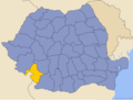
 Location of Caraş-Severin county on a map of Romania
 -
 Location of Călăraşi county on a map of Romania
 -
 Location of Cluj county on a map of Romania
 -
 Location of Constanţa county on a map of Romania
 -
 Location of Covasna county on a map of Romania
 -
 Location of Dâmboviţa county on a map of Romania
 -
 Location of Dolj county on a map of Romania
 -
 Location of Galaţi county on a map of Romania
 -
 Location of Giurgiu county on a map of Romania
 -
 Location of Gorj county on a map of Romania
 -
 Location of Harghita county on a map of Romania
 -
 Location of Hunedoara county on a map of Romania
 -
 Location of Ialomiţa county on a map of Romania
 -
 Location of Iaşi county on a map of Romania
 -
 Location of Ilfov county on a map of Romania
 -
 Location of Maramureş county on a map of Romania
 -
 Location of Medehinţi county on a map of Romania
 -
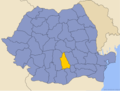
 Location of Mureş county on a map of Romania
 -
 Location of Neamţ county on a map of Romania
 -
 Location of Olt county on a map of Romania
 -
 Location of Prahova county on a map of Romania
 -
 Location of Satu Mare county on a map of Romania
 -
 Location of Sălaj county on a map of Romania
 -
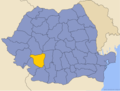
 Location of Sibiu county on a map of Romania
 -
 Location of Suceava county on a map of Romania
 -
 Location of Teleorman county on a map of Romania
 -
 Location of Timiş county on a map of Romania
 -
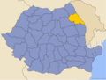
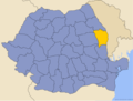
 Location of Tulcea county on a map of Romania
 -
 Location of Vâlcea county on a map of Romania
 -
 Location of Vaslui county on a map of Romania
 -
 Location of Vrancea county on a map of Romania


Historical Maps[edit]
-
 Romania after WWII. Lost territories are marked in yellow
