Category:Wahn (Hümmling)
Jump to navigation
Jump to search
| Object location | | View all coordinates using: OpenStreetMap |
|---|
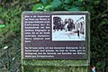
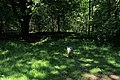
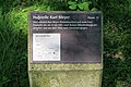
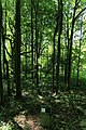
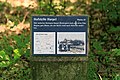
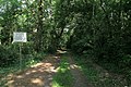
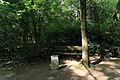
abandoned village  | |||||
| Upload media | |||||
| Instance of | |||||
|---|---|---|---|---|---|
| Location | Sögel, Emsland, Lower Saxony, Germany | ||||
 | |||||
Subcategories
This category has the following 8 subcategories, out of 8 total.
Media in category "Wahn (Hümmling)"
The following 64 files are in this category, out of 64 total.
-
 Sögel - K168 + Wahn 01 ies.jpg 5,616 × 3,745; 23.19 MB
-
 Sögel - K168 + Wahn 02 ies.jpg 3,744 × 5,616; 18.48 MB
-
 Sögel - K168 + Wahn 03 ies.jpg 5,616 × 3,744; 18.05 MB
-
 Sögel - L53 + Wahn 01 ies.jpg 5,616 × 3,744; 32.01 MB
-
 Sögel - L53 + Wahn 02 ies.jpg 5,616 × 3,744; 19.02 MB
-
 Sögel - L53 + Wahn 03 ies.jpg 5,616 × 3,744; 27.14 MB
-
 Sögel - L53+K168 + Wahn 01 ies.jpg 5,616 × 3,744; 27.36 MB
-
 Sögel - L53+K168 + Wahn 02 ies.jpg 5,616 × 3,745; 21.33 MB
-
 Sögel - L53+K168 + Wahn 03 ies.jpg 5,616 × 3,744; 27.1 MB
-
 Sögel - L53+K168 + Wahn 04 ies.jpg 5,616 × 3,744; 23.29 MB
-
 Sögel - L53+K168 + Wahn 05 ies.jpg 3,744 × 5,616; 16.81 MB
-
 Sögel - Wahn 01 ies.jpg 5,616 × 3,744; 28.57 MB
-
 Sögel - Wahn 02 ies.jpg 5,616 × 3,744; 28.72 MB
-
 Sögel - Wahn 03 ies.jpg 5,616 × 3,744; 15.2 MB
-
 Sögel - Wahn 04 ies.jpg 5,616 × 3,744; 17.42 MB
-
 Sögel - Wahn 05 ies.jpg 5,616 × 3,744; 25.62 MB
-
 Sögel - Wahn 06 ies.jpg 5,616 × 3,744; 17.41 MB
-
 Sögel - Wahn 07 ies.jpg 5,616 × 3,744; 20.41 MB
-
 Sögel - Wahn 08 ies.jpg 5,616 × 3,744; 28.64 MB
-
 Sögel - Wahn 09 ies.jpg 5,616 × 3,744; 29.65 MB
-
 Sögel - Wahn 10 ies.jpg 5,616 × 3,743; 19.73 MB
-
 Sögel - Wahn 11 ies.jpg 5,616 × 3,743; 18.79 MB
-
 Sögel - Wahn 12 ies.jpg 5,616 × 3,744; 18.48 MB
-
 Sögel - Wahn 13 ies.jpg 5,616 × 3,744; 28.92 MB
-
 Sögel - Wahn 14 ies.jpg 5,616 × 3,744; 17.29 MB
-
 Sögel - Wahn 15 ies.jpg 5,616 × 3,744; 18.98 MB
-
 Sögel - Wahn 16 ies.jpg 5,616 × 3,744; 27.63 MB
-
 Sögel - Wahn 17 ies.jpg 5,616 × 3,744; 18.59 MB
-
 Sögel - Wahn 18 ies.jpg 5,616 × 3,744; 26.82 MB
-
 Sögel - Wahn 19 ies.jpg 5,616 × 3,744; 19.32 MB
-
 Sögel - Wahn 20 ies.jpg 5,616 × 3,745; 16.81 MB
-
 Sögel - Wahn 21 ies.jpg 5,616 × 3,744; 31.56 MB
-
 Sögel - Wahn 22 ies.jpg 5,616 × 3,744; 31.04 MB
-
 Sögel - Wahn 23 ies.jpg 5,616 × 3,744; 16.77 MB
-
 Sögel - Wahn 24 ies.jpg 5,616 × 3,744; 27.2 MB
-
 Sögel - Wahn 25 ies.jpg 5,616 × 3,743; 17.79 MB
-
 Sögel - Wahn 26 ies.jpg 5,616 × 3,744; 27.67 MB
-
 Sögel - Wahn 27 ies.jpg 5,616 × 3,745; 17.38 MB
-
 Sögel - Wahn 28 ies.jpg 5,616 × 3,744; 27.31 MB
-
 Sögel - Wahn 29 ies.jpg 5,616 × 3,744; 27.24 MB
-
 Sögel - Wahn 30 ies.jpg 5,616 × 3,744; 20.04 MB
-
 Sögel - Wahn 31 ies.jpg 3,744 × 5,616; 27.85 MB
-
 Sögel - Wahn 32 ies.jpg 3,744 × 5,616; 27.97 MB
-
 Sögel - Wahn 33 ies.jpg 5,616 × 3,744; 21.61 MB
-
 Sögel - Wahn 34 ies.jpg 5,616 × 3,743; 19.29 MB
-
 Sögel - Wahn 35 ies.jpg 5,616 × 3,744; 24.2 MB
-
 Sögel - Wahn 36 ies.jpg 5,616 × 3,744; 23.18 MB
-
 Sögel - Wahn 37 ies.jpg 3,744 × 5,616; 28.04 MB
-
 Sögel - Wahn 38 ies.jpg 5,616 × 3,744; 30.68 MB
-
 Sögel - Wahn 39 ies.jpg 5,616 × 3,744; 25.37 MB
-
 Sögel - Wahn 40 ies.jpg 5,616 × 3,744; 16.98 MB
-
 Sögel - Wahn 41 ies.jpg 5,616 × 3,744; 30.23 MB
-
 Sögel - Wahn 42 ies.jpg 5,616 × 3,743; 19.06 MB
-
 Sögel - Wahn 43 ies.jpg 5,616 × 3,744; 27.12 MB
-
 Sögel - Wahn 44 ies.jpg 5,616 × 3,744; 28.22 MB
-
 Sögel - Wahn 45 ies.jpg 5,616 × 3,744; 29.38 MB
-
 Sögel - Wahn 46 ies.jpg 5,616 × 3,744; 23.97 MB
-
 Sögel - Wahn 47 ies.jpg 5,616 × 3,744; 18.98 MB
-
 Sögel - Wahn 48 ies.jpg 5,616 × 3,744; 25.23 MB
-
 Sögel - Wahn 49 ies.jpg 5,616 × 3,744; 28.46 MB
-
 Sögel - Wahn 50 ies.jpg 5,616 × 3,744; 26.88 MB
-
 Sögel - Wahn 51 ies.jpg 5,616 × 3,744; 28.99 MB
-
 Sögel - Wahn 52 ies.jpg 5,616 × 3,744; 16.81 MB
-
 Sögel - Wahn 53 ies.jpg 3,745 × 5,616; 21.9 MB


