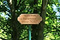
Category:Marienklause in Wahn (Hümmling)
Jump to navigation
Jump to search
| Object location | | View all coordinates using: OpenStreetMap |
|---|
| Upload media | |||||
| Instance of | |||||
|---|---|---|---|---|---|
| Location | Sögel, Emsland, Lower Saxony, Germany | ||||
 | |||||
Media in category "Marienklause in Wahn (Hümmling)"
The following 8 files are in this category, out of 8 total.
-
 Sögel - Wahn - Marienklause 01 ies.jpg 5,616 × 3,744; 19.98 MB
-
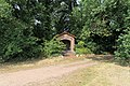 Sögel - Wahn - Marienklause 02 ies.jpg 5,616 × 3,744; 28.09 MB
-
 Sögel - Wahn - Marienklause 03 ies.jpg 5,616 × 3,744; 27.25 MB
-
 Sögel - Wahn - Marienklause 04 ies.jpg 5,616 × 3,743; 20.16 MB
-
 Sögel - Wahn - Marienklause 05 ies.jpg 3,743 × 5,616; 20.55 MB
-
 Sögel - Wahn - Marienklause 06 ies.jpg 3,744 × 5,616; 18.45 MB
-
 Sögel - Wahn - Marienklause 07 ies.jpg 3,744 × 5,616; 22.02 MB
-
 Sögel - Wahn - Marienklause 08 ies.jpg 3,743 × 5,616; 17.96 MB


