Category:Maps of Bosnia and Herzegovina
Jump to navigation
Jump to search
Countries of Europe: Albania · Andorra · Armenia‡ · Austria · Azerbaijan‡ · Belarus · Belgium · Bosnia and Herzegovina · Bulgaria · Croatia · Cyprus‡ · Czech Republic · Denmark · Estonia · Finland · France‡ · Georgia‡ · Germany · Greece · Hungary · Iceland · Republic of Ireland · Italy · Kazakhstan‡ · Latvia · Liechtenstein · Lithuania · Luxembourg · Malta · Moldova · Monaco · Montenegro · Netherlands‡ · North Macedonia · Norway · Poland · Portugal‡ · Romania · Russia‡ · San Marino · Serbia · Slovakia · Slovenia · Spain‡ · Sweden · Switzerland · Turkey‡ · Ukraine · United Kingdom · Vatican City
Specific status: Akrotiri and Dhekelia‡ · Faroe Islands · Gibraltar · Bailiwick of Guernsey · Isle of Man · Jersey · Svalbard – Limited recognition: Abkhazia‡ · Gagauzia · Kosovo · South Ossetia‡ · Transnistria · Northern Cyprus‡ · United Nations Buffer Zone in Cyprus‡
‡: partly located in Europe
Specific status: Akrotiri and Dhekelia‡ · Faroe Islands · Gibraltar · Bailiwick of Guernsey · Isle of Man · Jersey · Svalbard – Limited recognition: Abkhazia‡ · Gagauzia · Kosovo · South Ossetia‡ · Transnistria · Northern Cyprus‡ · United Nations Buffer Zone in Cyprus‡
‡: partly located in Europe
Wikimedia category | |||||
| Upload media | |||||
| Instance of | |||||
|---|---|---|---|---|---|
| Category combines topics | |||||
 | |||||
Subcategories
This category has the following 39 subcategories, out of 39 total.
*
C
D
F
G
H
L
M
O
P
R
S
T
Pages in category "Maps of Bosnia and Herzegovina"
The following 2 pages are in this category, out of 2 total.
Media in category "Maps of Bosnia and Herzegovina"
The following 28 files are in this category, out of 28 total.
-
 20170109 SE Europe SW v2.pdf 1,625 × 1,125; 806 KB
-
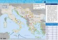
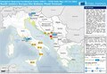
 20170717 IT HR BiH ME ForestFires.pdf 1,625 × 1,125; 946 KB
-
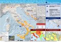
 20170719 DailyMap IT HR BiH ME ForestFires.pdf 1,754 × 1,239; 1.09 MB
-
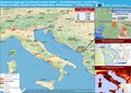
 20170727 Forest Fires in Southern Europe.pdf 1,625 × 1,125; 988 KB
-
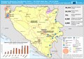 20191128 DM Bosnia refugee.pdf 1,754 × 1,239; 871 KB
-
 Bosnia and Hercegovina (Herzegovina) - DPLA - 0ef8ef9ab05c35ce37479dbc572c9da0.jpg 2,630 × 3,282; 5.45 MB
-
 Bosnia and Herzegovina - DPLA - 26ceae64b780f1ceb344f21bee53a83f.jpg 2,554 × 3,278; 4.97 MB
-
 Bosnia and Herzegovina - DPLA - 409fd111fd4cd1f40e1b2b44b0b81951.jpg 2,556 × 3,278; 5.77 MB
-
 Bosnia and Herzegovina - DPLA - 7f1cd0540349148957e1861515292d15.jpg 2,554 × 3,276; 5.84 MB
-
 Bosnia and Herzegovina - DPLA - 8b903054f77310e1d84cb7450772cd17.jpg 2,554 × 3,278; 5.53 MB
-
 Bosnia regions by hdi.png 971 × 772; 65 KB
-
 BosniaandHerzegovina regions by HDI(FIXED).png 932 × 780; 65 KB
-
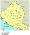
 Bosnianlanguagemap.png 2,552 × 1,604; 484 KB
-
 ECDM 20150210 World Events.pdf 1,625 × 1,125; 446 KB
-
 ECDM 20150918 WesternBalkansRoute.pdf 1,754 × 1,239; 1.18 MB
-
 ECDM 20161107 EuropeFloodForecast SE.pdf 1,625 × 1,125; 733 KB
-
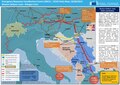
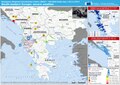 ECDM 20171130 Western-Balkans Severe Weather.pdf 2,479 × 1,754; 1.07 MB
-
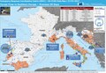
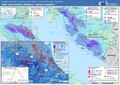 ECDM 20230519 ST Italy Balkans(1).pdf 2,479 × 1,754; 1.3 MB
-
 Herzegbosnia.png 1,809 × 1,752; 149 KB
-
 Hrvatska Samouprava u BiH 2001.png 1,100 × 1,070; 153 KB
-
 Hrvatski prostori u BiH.png 1,100 × 1,070; 154 KB
-
 Map of UN Safe Areas in Bosnia and Herzegovina 1993-1995.png 1,920 × 1,824; 190 KB
-
 Mapa entitats de Bòsnia.png 1,103 × 1,044; 51 KB
-
 Patriarchate of Peć in the 16th and 17th century.png 1,170 × 1,383; 129 KB
-
 Pecka patrijarsija mapa sr.png 1,170 × 1,383; 123 KB
-
 Policija RS - Policijske uprave.tif 3,507 × 2,480; 2.11 MB
-
 Prepolovljene-opcine.gif 800 × 760; 102 KB
-
 Prosrpsko raspoloženje u BiH 1919.png 2,000 × 2,000; 468 KB
_-_DPLA_-_0ef8ef9ab05c35ce37479dbc572c9da0.jpg)


.png)


