Category:Maps of the UN Buffer Zone in Cyprus
Jump to navigation
Jump to search
Countries of Europe: Cyprus‡
‡: partly located in Europe
‡: partly located in Europe
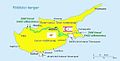
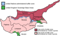
English: This category contains maps of the United Nations Buffer Zone in Cyprus, which runs for more than 180.5 kilometres (112.2 mi) along what is known as the Green Line and has an area of 346 square kilometres (134 sq mi). The zone partitions the island of Cyprus into a southern area effectively controlled by the government of the Republic of Cyprus (which is the de jure government for the entire island save for the British Sovereign Base Areas), and the northern area controlled by the Turkish Republic of Northern Cyprus.
Subcategories
This category has only the following subcategory.
Media in category "Maps of the UN Buffer Zone in Cyprus"
The following 8 files are in this category, out of 8 total.
-
 Ciprus közigazgatási kerületei.png 600 × 365; 53 KB
-
 Ciprus Zold Vonal.jpg 629 × 319; 69 KB
-
 Cyprus BufferZoneInBlue.png 630 × 321; 21 KB
-
 Cyprus districts named.png 600 × 365; 22 KB
-
 Cyprus-administration-map-german.PNG 563 × 324; 17 KB
-
 The Attila Line Proposed by Turkey.png 1,686 × 886; 692 KB
-
 UNFICYP Jun 14.png 960 × 720; 368 KB
-
 UNFICYP map may 2011.jpg 2,551 × 1,974; 908 KB


