File:EB9 United States - historical maps (bottom).jpg
Jump to navigation
Jump to search
Size of this preview: 750 × 600 pixels. Other resolutions: 300 × 240 pixels | 600 × 480 pixels | 961 × 768 pixels | 1,280 × 1,024 pixels | 2,501 × 2,000 pixels.
Original file (2,501 × 2,000 pixels, file size: 942 KB, MIME type: image/jpeg)
Captions
Captions
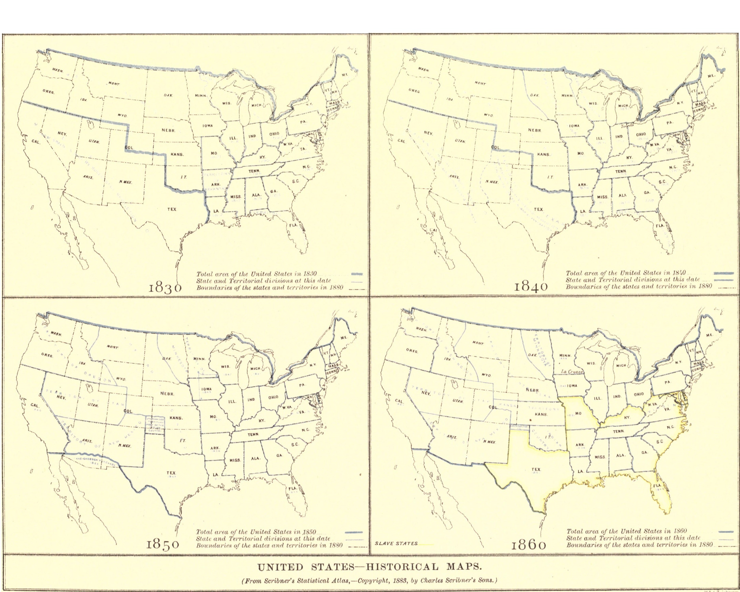
4 maps from the history of the United States: its expansion and divisions in 1830, 1840, 1850, and 1860.
Summary[edit]
| Description |
English: 4 historical maps of the United States, the bottom half of Plate VII. in the article "United States" in the American version of the Encyclopaedia Britannica, 9th ed. 1830, depicting the dates of states' admissions to the United States, the Arkansas Territory, and various other changes in the 1810s and 1820s with illegible blue text. Total area of the United States in 1830 depicted with a thick blue line, State and Territorial divisions at this date depicted with thin blue lines, & Boundaries of the states and territories in 1880 depicted with a black dot-and-dash line. 1840, depicting the dates of states' admissions to the United States, the Iowa Territory, the Republic of Texas, and various other changes in the 1810s with illegible blue text. Total area of the United States in 1840 depicted with a thick blue line, State and Territorial divisions at this date depicted with thin blue lines, & Boundaries of the states and territories in 1880 depicted with a black dot-and-dash line. 1850, depicting the dates of states' admissions to the United States, the Minnesota, Oregon, Utah, and New Mexico Territories, the Unorganized Territory west of the Indian Country, the Gadsden Purchase, and various other changes in the 1840s with illegible blue text. Total area of the United States in 1850 depicted with a thick blue line, State and Territorial divisions at this date depicted with thin blue lines, & Boundaries of the states and territories in 1880 depicted with a black dot-and-dash line. 1860, depicting the dates of states' admissions to the United States, the Washington, Nebraska, Utah, New Mexico, Kansas, and Minnesota Territories, Indian Country, and various other changes in the 1850s with illegible blue text. slave states [yellow]. Total area of the United States in 1860 depicted with a thick blue line, State and Territorial divisions at this date depicted with thin blue lines, & Boundaries of the states and territories in 1880 depicted with a black dot-and-dash line. La Crosse inexplicibly marked in Minnesota. |
|||
| Date | ||||
| Source | “United States” in the Encyclopædia Britannica, 9th ed., Vol. XXIII, Plate VII. (bottom), between pp. 728 and 729. | |||
| Author | Anonymous, from an original in Scribner's Historical Atlas, published by Charles Scribner's Sons, engraved by William & Alexander Keith Johnston | |||
| Permission (Reusing this file) |
|
|||
| Other versions |
|

.jpg)
.jpg&action=edit§ion=1)
File history
Click on a date/time to view the file as it appeared at that time.
| Date/Time | Thumbnail | Dimensions | User | Comment | |
|---|---|---|---|---|---|
| current | 21:51, 20 August 2018 | | 2,501 × 2,000 (942 KB) | Bob Burkhardt (talk | contribs) | {{Information |description ={{en|1=Historical maps of the United States for 1830, 1840, 1850, 1860.}} |date =1888 |source =“United States,” ''Encyclopædia Britannica'' (9th ed.), v. 23, 1888, Plate VII. (bottom), between pp. 728 and 729. |author =Charles Scribner's Sons (''Scribner's Historical Atlas'') |permission ={{PD-Britannica}} }} Category:Old maps of the United States |
You cannot overwrite this file.
File usage on Commons
The following page uses this file:
File usage on other wikis
The following other wikis use this file:
.jpg&oldid=784763959)
Categories:
- Old maps of the United States
- Maps of the history of the United States
- 1830 maps of the United States
- Maps of the history of Arkansas
- Arkansas Territory
- 1840 maps of the United States
- Maps of the history of Texas
- Maps of the Republic of Texas
- Maps of the history of Iowa
- Iowa Territory
- Maps of the history of Florida
- Florida Territory
- 1850 maps of the United States
- Maps of the history of Utah
- Utah Territory
- Maps of the history of New Mexico
- New Mexico Territory
- Maps of the history of Minnesota
- Minnesota Territory
- Maps of the history of Arizona
- Gadsden Purchase
- 1860 maps of the United States
- Slavery in the United States
- Maps of the history of Washington (state)
- Washington Territory
- Maps of the history of Nebraska
- Nebraska Territory
- Maps of the history of Kansas
- Kansas Territory
- Maps of the history of Oklahoma
- Maps of the Indian Territory
- 1888 engravings
- William Johnston (1802-1888)
- Maps by Alexander Keith Johnston (1804–1871)
- Engravings from the United Kingdom
- 1888 maps of the United States
- Maps from Encyclopædia Britannica