Commons:Graphic Lab/Map workshop/Archive/2018
 | This is an archive of past discussions. Do not edit the contents of this page. If you wish to start a new discussion or revive an old one, please do so on the current talk page. |
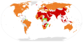
Right-wing populism map
-
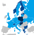 European national parliaments with representatives from right-wing populist parties in 2016—in dark blue, those in government.
.png)
Article(s): en:Right-wing populism
- Change UK to either light or medium blue
- The en:Democratic Unionist Party is in the parliament and supports the Conservative Party government. The DUP is a right-wing populist party (see here -- source: Ingle, Stephen (2008). The British Party System: An Introduction. Routledge. p. 156.) -- and it's agreement with the Tories may quality the UK for being shaded medium blue.
- Either way, the UK should be shaded at least light blue, as the DUP sits in parliament, and some factions of the Conservative Party (including some MPs) are right-wing populist.[1] --1990'sguy (talk) 14:30, 17 January 2018 (UTC)
- Graphist opinion(s)
@1990'sguy: You should check the description of that file as Maphobbyist seems to have fulfilled this, so I make it ![]() Done --Goran tek-en (talk) 18:23, 26 January 2018 (UTC)
Done --Goran tek-en (talk) 18:23, 26 January 2018 (UTC)
- Yes, it has been fulfulled -- Maphobbyist notified me on my talk page about this, but I neither of us apparently noted it here. --1990'sguy (talk) 02:47, 27 January 2018 (UTC)
Then it should be archived also :This section was archived on a request by: Goran tek-en (talk) 11:49, 27 January 2018 (UTC)
FBS Independent Schools Map

Article(s): en:NCAA Division I FBS independent schools
- Request
- Need to modify the map to include Virginia (home of Liberty University) and New Mexico (home of New Mexico State) which will be FBS Independents for the 2018 football season. --Jayron32 (talk) 20:09, 10 January 2018 (UTC)
- Graphist opinion(s)
![]() Done :This section was archived on a request by: Blervis (talk) 21:13, 1 February 2018 (UTC)
Done :This section was archived on a request by: Blervis (talk) 21:13, 1 February 2018 (UTC)
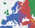
Time zone maps of Europe
-
 Europe time zones map.png
 -
 Europe time zones map de.png
 -
 Europe time zones map en.png
 -
 Europe time zones map fr.png
 -
 Europe time zones map tr corrected.png
 -
 Europe time zones map tr.png
 -
 Europe time zones map multilingüe.jpg


Article(s): Many
- Request
- These time zone maps of Europe files are obsolete and need to be updated because they don't show the latest changes for Northern Cyprus,Turkey or Crimea. Northern Cyprus reverted back to UTC+2 and Daylight Saving Time (DST). Crimea and Turkey are in time zone UTC+3 and don't use Daylight Saving Time (DST). The de-facto situation in Crimea does not imply endorsement of any side of the conflict but only reflects the actual usage. Furthermore many Wikipedia articles use these files. For reference see the source: https://www.timeanddate.com/ --Maphobbyist (talk) 23:22, 2 January 2018 (UTC)
- Graphist opinion(s)
![]() Done
Done
- This section was archived on a request by: Maphobbyist (talk) 13:36, 6 February 2018 (UTC)
update of map showing orbital launch capabilities
-
 Map displaying orbital launches by country

Article(s): en:Timeline of first orbital launches by country; similar articles in other language WPs
- Request
- New Zealand launched its first orbital rocket today (details here); as such, its colour needs to be changed on this map
- The two main islands of New Zealand (and accompanying offshore islands immediately to the south and east) need to be shaded red, replacing the current green shade. --Grutness (talk) 03:06, 21 January 2018 (UTC)
- Graphist opinion(s)
![]() Request taken by Goran tek-en (talk) 18:15, 26 January 2018 (UTC)
Request taken by Goran tek-en (talk) 18:15, 26 January 2018 (UTC)
![]() Done --Goran tek-en (talk) 18:16, 26 January 2018 (UTC)
Done --Goran tek-en (talk) 18:16, 26 January 2018 (UTC)
- This section was archived on a request by: Goran tek-en (talk) 19:20, 6 February 2018 (UTC)
Borders of South Sudan
-
 Fatimid Caliphate Map in Arabic
 -
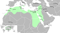 Fatimid Caliphate Map in English
 -
 Fatimid Caliphate Map in Hebrew
 -
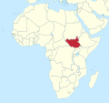 South Sudan


_(-mini_map_-rivers).svg)
- Request
- Can you please add the boarders of Southern Sudan to the first 3 maps--باسم (talk) 18:22, 6 February 2018 (UTC)
- Graphist opinion(s)
![]() Done – Now South Sudan is shown in all three maps. NNW 16:43, 21 February 2018 (UTC)
Done – Now South Sudan is shown in all three maps. NNW 16:43, 21 February 2018 (UTC)
- This section was archived on a request by: NNW 16:43, 21 February 2018 (UTC)
Operation Olive Branch
-
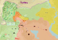 Map of the Turkish operation against Kurdish-held territory in northern Syria.

Article(s): ar:هجوم عفرين
- Request
- Would you please translate the English text into Arabic. In addition to a legend describes the colors used.
 --Aladdin (talk) 07:33, 30 January 2018 (UTC)
- @Goran tek-en: Thank you for your response, Concerning translation, Please find it below:
- Turkey: تركيا
- Aleppo: حلب
- Afrin: عفرين
- Manbij: منبج
- Al-Bab: الباب
- Concerning the legend, the colores are below:
- Red: Syrian Armed Forces & Allied Groups (القوات المسلحة السورية والمجموعات الحليفة لها)
- Green: Free Syrian Army and Turkish Troops (الجيش السوري الحر والقوات التركية).
- Yellow: Syrian Democratic Forces (قوات سوريا الديمقراطية).
--Aladdin (talk) 15:04, 7 February 2018 (UTC)
- Graphist opinion(s)
@علاء الدين: T o be able to do this we (graphic workers) would need the translation and the text corresponding to which color for the legend. We are graphic workers and have no knowledge about your subject, thanks. --Goran tek-en (talk) 19:19, 6 February 2018 (UTC)
![]() Request taken by Goran tek-en (talk) 16:44, 12 February 2018 (UTC)
Request taken by Goran tek-en (talk) 16:44, 12 February 2018 (UTC)
- @علاء الدين: Sorry for the delay but now there is a draft for you to check. Give me feedback, please ping me, thanks. --Goran tek-en (talk) 14:01, 18 February 2018 (UTC)
- @Goran tek-en: ; I'm sorry for being late, but I have some problems with my internet connection, therefore, I can't see the complete SVG file. If it's applicable, I believe, JPG file will be easier to be seen. Anyway, if you think it's good, you can upload it to commons. Thank you very much for your efforts.--Aladdin (talk) 08:00, 27 February 2018 (UTC)
@علاء الدين: Now you can find it here file:Operation Olive Branch-ar.svg. You have to add the Arabic explanation. If you are happy with this please put the code {{section resolved|1=~~~~}} on this request so it can be archived, thanks. ![]() Done --Goran tek-en (talk) 13:15, 27 February 2018 (UTC)
Done --Goran tek-en (talk) 13:15, 27 February 2018 (UTC)
- This section was archived on a request by: Goran tek-en (talk) 16:49, 5 March 2018 (UTC)
Map of bombing of Damascus and Homs
-
 Map of 2018 bombing of Damascus and Homs released by the US Department of Defense

Article(s): ar:قصف دمشق وحمص في 2018
- Request
- Please translate the texts in this map into Arabic Language, It would be very easier to be read by Arabs.--Aladdin (talk) 07:13, 15 April 2018 (UTC)
- Graphist opinion(s)
![]() Done by @Mohmd1429: . check the map--باسم (talk) 11:22, 16 April 2018 (UTC)
Done by @Mohmd1429: . check the map--باسم (talk) 11:22, 16 April 2018 (UTC)
 Comment @Mohmd1429 and باسم: , Thank you both for your efforts. Kindly note that the airport within Damascus Rural is "الضمير" (Dumair) not "تدمر" (Palmyra). In addition, Al Quneitra Governorate is on the western side of Dar'a, but in Arabic maps, it looks like on its north. One more thing, the word "الصفا" near Tiyas airport wasn't mentioned on the original map nor on its English wikipedia article nor in its Arabic one.--Aladdin (talk) 12:01, 16 April 2018 (UTC)
@علاء الدين: ![]() Done I correct what you said the map --Mohmd1429 (talk) 12:30, 16 April 2018 (UTC)
Done I correct what you said the map --Mohmd1429 (talk) 12:30, 16 April 2018 (UTC)
- @Mohmd1429: Thanks a lot
 Like.--Aladdin (talk) 12:35, 16 April 2018 (UTC)

- This section was archived on a request by: --باسم (talk) 18:57, 16 April 2018 (UTC)
File:Stolpersteine in Europe.svg IS WRONG, please correct it a.s.a.p.
-
 Map of countries with Stolpersteine

Article(s):
- de:Liste der Orte mit Stolpersteinen
- en:List of cities by country that have stolpersteine
- it:Pietre d'inciampo
- zh:绊脚石 (艺术项目)
- nn:Snublesteinar and some more
- Request
- Please UNLIST Belarus. There are NO Stolpersteine there. Yes, the collocation of Stolpersteine in Belarus has been announced (but for unknown reasons it never happened.) Please do not ask for proof. There is no proof for something that never happened. --Meister und Margarita (talk) 18:34, 23 May 2018 (UTC)
- Graphist opinion(s)
![]() Done – when the request is done.
Done – when the request is done.
- This section was archived on a request by: CorrectHorseBatteryStaple (talk) 22:58, 27 May 2018 (UTC)
Golden jackal range modification for Turkey
-
 Current map

Golden jackal:
- Request
- Update range map
- Species range in Turkey should be reduced, in accordance with figure 3 in this research paper --Mariomassone (talk) 11:42, 23 March 2018 (UTC)
- Graphist opinion(s)
![]() Request taken by Goran tek-en (talk) 14:56, 14 June 2018 (UTC)
Request taken by Goran tek-en (talk) 14:56, 14 June 2018 (UTC)
@Mariomassone: Is this correct? --Goran tek-en (talk) 16:56, 14 June 2018 (UTC)
- Perfect! Thank you so much. It would be great if we could use it to overwrite the original, that way we don't get yet another range map on commons. Mariomassone (talk) 16:59, 14 June 2018 (UTC)
- @Mariomassone: Now you can find it as an update of the original file. If you are happy with this please put the code
{{section resolved|1=~~~~}}on this request so it can be archived, thanks. Done --Goran tek-en (talk) 17:52, 14 June 2018 (UTC)
- @Mariomassone: Now you can find it as an update of the original file. If you are happy with this please put the code
- This section was archived on a request by: Mariomassone (talk) 17:57, 14 June 2018 (UTC)
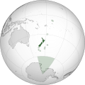
Vectorise and update NZ map
-
 Map identifying New Zealand, its territories and associated states
 -
 Orthographic map (unlabelled)
 -
 Orthographic map (labelled with English and Māori names)


Article(s): en:Realm of New Zealand
- Request
- Please vectorise the file, improve the text labels and (optionally) correct the map by inserting a border for South Sudan--Hazhk (talk) 00:41, 12 February 2018 (UTC)
- Graphist opinion(s)
- I've always found the presence of this map on the New Zealand page to be odd. What's wrong with just adding labels to the existing orthographic map of New Zealand? That would remove issues with Sudan, because it's on the other side of the globe. Gringer (talk) 13:30, 10 March 2018 (UTC)
- Done Labelled orthographic version of the map with English and Māori names. Gringer (talk) 13:30, 10 March 2018 (UTC)
- This section was archived on a request by: Yann (talk) 20:08, 5 July 2018 (UTC)
Mount Tambora
-
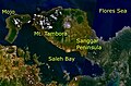 Mount Tambora
 -
 Done
Done


Article(s): tr:Tambora_Dağı
- Request
- Can you translate in Turkish language?
- Mt. Tambora → Tambora Dağı
- Saleh Bay → Saleh Körfezi
- Flores Sea → Flores Denizi --Hedda Gabler (talk) 15:41, 21 February 2018 (UTC)
- Graphist opinion(s)
- This section was archived on a request by: Yann (talk) 20:08, 5 July 2018 (UTC)
Stolpersteine in Europe
Article(s): de:Liste der Orte mit Stolpersteinen
- Request
- Please add Latvia in orange
- The first collocations of Stolpersteine in Latvia took place in Riga on July 28, 2018.--Meister und Margarita (talk) 14:38, 7 August 2018 (UTC)
- This section was archived on a request by: CorrectHorseBatteryStaple (talk) 04:49, 9 August 2018 (UTC)
Saint Pierre and Miquelon
- This section was archived on a request by: Kintetsubuffalo (talk) 10:52, 11 August 2018 (UTC)

- Article(s)
- en:Saint Pierre and Miquelon
- Request
- please create closeup map of the islands in relation to Newfoundland. The article has two long-distance maps which show them as specks… --Kintetsubuffalo (talk) 01:50, 11 June 2018 (UTC)
- Graphist opinion(s)
![]() Done @Kintetsubuffalo: I transferred File:Saint Pierre et Miquelon Map.svg into a commonly used format with larger text. If you need a somewhat larger overview, let me know. De728631 (talk) 19:35, 3 August 2018 (UTC)
Thank you!--Kintetsubuffalo (talk) 10:52, 11 August 2018 (UTC)
Done @Kintetsubuffalo: I transferred File:Saint Pierre et Miquelon Map.svg into a commonly used format with larger text. If you need a somewhat larger overview, let me know. De728631 (talk) 19:35, 3 August 2018 (UTC)
Thank you!--Kintetsubuffalo (talk) 10:52, 11 August 2018 (UTC)
French version of File:Air_Canada_Flight_797_seat_injury_chart.svg
Article(s): fr:Vol 797 Air Canada
- Request
- Please make a French version of File:Air_Canada_Flight_797_seat_injury_chart.svg.
The big labels, respectively, should be "Decès," "Survivants," and "Agents de bord".
Smaller:
- aft lavatory -> toilettes à l'arrière
- galley #1 -> office no 1
- galley #2 -> office no 2
- aux. galley -> office auxiliaire
- galley service door -> porte d'service du office
- side window -> fenêtre latérale
- passenger exterior door -> porte passager extérieure
- double flight attendant seat -> siège 2 places de l'agent de bord
- Aft stowage -> arrimage à l'arrière
Thanks! --WhisperToMe (talk) 18:22, 16 April 2018 (UTC)
- Graphist opinion(s)
 Request taken by KCVelaga (talk · mail) 09:14, 10 September 2018 (UTC)
- Done @WhisperToMe: Please check the translated version at: File:Air Canada Flight 797 seat injury chart-fr.svg. KCVelaga (talk · mail) 09:36, 10 September 2018 (UTC)
- This section was archived on a request by: KCVelaga (talk · mail) 06:44, 23 September 2018 (UTC)
Color countries in SVG maps
-
 Color Argentina orange
 -
 Color Argentina red


Article(s): Legality of child pornography and Bicycle helmet laws by country
- Request
- Possession of child pornography is illegal in Argentina, should be colored orange. Bicycle helmets are mandatory in Argentina, should be colored red. Thanks. --Yilku1 (talk) 20:30, 26 September 2018 (UTC)
- Graphist opinion(s)
![]() Done – @Yilku1: Had some issues with cache on the laptop, but viewing on phone, I can see the newer file. I guess it is done. Have a look, and if it is fine, please let me know so that I can mark it as resolved.
Done – @Yilku1: Had some issues with cache on the laptop, but viewing on phone, I can see the newer file. I guess it is done. Have a look, and if it is fine, please let me know so that I can mark it as resolved.
acagastya 22:05, 27 October 2018 (UTC)
- @Acagastya: Thank you! It's solved. --Yilku1 (talk) 22:36, 27 October 2018 (UTC)
- This section was archived on a request by: acagastya 22:59, 27 October 2018 (UTC)
Road traffic accidents world map
-
 Road traffic accidents world map - Death - WHO2012

Article(s): en:List of countries by traffic-related death rate
- Request
- The map is completely out of sync with the table in the article. Please update. Thanks, Yann (talk) 16:38, 23 October 2018 (UTC)
- Details of your request go here… --Yann (talk) 16:38, 23 October 2018 (UTC)
- Graphist opinion(s)
![]() Done – File:Road traffic accidents world map - Death - WHO2013.svg -- per the data of 2015. (The file needs rename, due to typo, but there is the newer map.
Done – File:Road traffic accidents world map - Death - WHO2013.svg -- per the data of 2015. (The file needs rename, due to typo, but there is the newer map.
acagastya 21:47, 27 October 2018 (UTC)
- This section was archived on a request by: acagastya 21:47, 27 October 2018 (UTC)
Map of Gascon campaign of 1345
-
 Map of Gascon campaign of 1345

Article(s): en:Gascon campaign of 1345
- Request
- I would like to request a map of the Gascon campaign of 1345, based on the following map. A change is also required to the text, from "Lancaster" to "Derby", as Henry had yet to succeed to Earldom of Lancaster during this campaign. Regards Newm30 (talk) 06:20, 12 November 2018 (UTC)
- Graphist opinion(s)
![]() Request taken by Goran tek-en (talk) 15:04, 12 November 2018 (UTC)
Request taken by Goran tek-en (talk) 15:04, 12 November 2018 (UTC)
@Newm30: A first draft for you to check. The base map is drawn from today map so if some important area has changed you have to tell me. Check everything and give me feedback, thanks. --Goran tek-en (talk) 19:23, 13 November 2018 (UTC)
- @Goran tek-en: Thank you for creating the first draft. I have the following comments and suggestions. Regards Newm30 (talk) 08:07, 15 November 2018 (UTC)
- 1.
Can the Isle of Oléron, be named as Île d'Oléron. Done - 2.
Can St. Jean d'Angély, be named Saint-Jean-d'Angély. Done - 3.
Can La Réola. be renamed La Réole. Done - 4.
Could the dates in textbox be centered? Done - 5.
Can the "route" lines be made thicker? Done - 6.
The "route" line from Bordeaux to St Macarie needs to be as per Derby advance. Done - 7.
The "route" line from Périgieux to Saint-Émilion needs to be Derby retreat and could be a different colour/shade. Done - 8.
Can the "route" line from Auberoche start closer to the place marker and be a different colour/shade, including "route" line from Auberoche to La Réole? Done - 9.
Could Périgord be placed to NE of Périgieux, similar to text Saintonge, to identify County? Done
- 1.
Suggest Derby's advance be a solid red line and his retreat a broken one; that allows the same colour to be kept.Serial Number 54129 (talk) 08:38, 15 November 2018 (UTC)
- The map is looking great. For information the GAN is just wrapping up and I am hoping to move it straight on to ACR. Some thoughts:
10. The legend. Could the labels in this read:- Derby's retreat
- Derby's advance
- Derby's advance to Auberouche
Louis of Poitiers' advance Done
11. Could they be reordered as below, so as to be in chronological order, which I think will make more sense to a reader.- Derby's advance
- Derby's retreat
- Louis of Poitiers' advance
Derby's advance to Auberouche Done
12. Would it be possible to delete St Macarie, which is not mentioned in the text, and replace it with Langon, which is - several times? Langon is about 3 km WSW of St Macarie, on the west bank of the Garonne. Done13. Any chance that Aiguillon could be added? It is at the junction of the Lor and the Garonne, in the SE corner. Done- 14.
Périgueux is the capital of the province of Périgord. Would it be possible to have Périgord in a similar style to Agenais and Gascony? Done
- I have not used the map creation service myself and I am extremely impressed by the speed and quality on offer. Clearly I have been missing out. Many thanks for the work on this. Gog the Mild (talk) 11:17, 15 November 2018 (UTC)
- @Newm30: I'm just pinging you, you contact the others needed.
- New draft, check it and give me feedback, thanks. I just realized I had put St Emilion in a wrong position, now updated. --Goran tek-en (talk) 18:05, 15 November 2018 (UTC)
Regarding #8, there is only 1 line going from Auberoche but you are talking about 2 different, I don't understand?
You have fixed the issue. Sorry for the confusion. Done
My idea with keeping the same broken line for all Derby movement and then change the outline is to keep some uniformity, to me it's easier to view the information in the map.
Ok, I understand, leave as is. Can we change route lines Derby's retreat to Orange and Derby's advance to Auberouche to Purple and Derby's XXX (return to La Réole) Green? Done
As St Macarie was requested to be removed should the lines to/from St Macarie be changed to Langon?
There is no mention of Derby retreated to Langon. Keep St Macrie at present and see whether Langon could be added. Done
- In the legend should the line/arrow with green and XXX be included and if so which text and order?
Keep and name Derby's return to La Réole. Suggested green colour of route line above. Done
- @Newm30: I'm just pinging you, you contact the others needed.
- I have not used the map creation service myself and I am extremely impressed by the speed and quality on offer. Clearly I have been missing out. Many thanks for the work on this. Gog the Mild (talk) 11:17, 15 November 2018 (UTC)
- Responses above. Have stuck through completed requests/suggestions. Newm30 (talk) 01:48, 16 November 2018 (UTC)
- Oops forgot to ping you again @Goran tek-en: . Newm30 (talk) 01:50, 16 November 2018 (UTC)
- @Goran tek-en: - I just remembered another couple of questions?
Can we put battle markers at Auberoche and Bergerac? DoneAnother route line for Louis of Poitiers' advance should also be shown between Périgieux and Auberoche. Done
- BTW, The map is looking fantastic. Regards Newm30 (talk) 01:56, 16 November 2018 (UTC)
- @Newm30: Thanks for pinging me and keeping this request easier for me to grasp. Draft 4.
- Neither orange or purple is very visible against the red line so right now I haven't changed anything, and why do you need outline color for line toward Auberoche, it has another type of dashed line? --Goran tek-en (talk) 17:55, 16 November 2018 (UTC)
- @Goran tek-en:
- Last questions/suggestions:
(a) Can the line for Derby's return to La Réole be green instead of red line with green highlight?- (b) Can the line for Derby's retreat be Orange instead of a red line?
- (c) Can the line for Derby's advance to Auberouche be Purple instead of a red line?
- (d) Can Angoulême be placed to closeby NE of Angoulême, similar to text Saintonge, to identify County?
(e) Can County identifier Agenais (large font) be moved to east of Aiguillon. Done Thanks Newm30 (talk) 05:23, 17 November 2018 (UTC)
- Regards Newm30 (talk) 05:14, 17 November 2018 (UTC)
- @Newm30: Thanks for pinging me and keeping this request easier for me to grasp. Draft 4.
@Goran tek-en: - Perfect!!!! Thank you very much for creating the map. This will be very helpful in understanding the campaign. Regards Newm30 (talk) 04:39, 18 November 2018 (UTC) @Newm30: I will need the following;
- Name of the file
- Description
- Map of the Gascon campaign of 1345, part of the Hundred Years' War. This map shows the English and French army movements during the campaign and the most important battles.
- Category/ies at commons
- Category:Maps of the Hundred Years' War
to be able to upload it at commons. --Goran tek-en (talk) 17:27, 18 November 2018 (UTC)
- @Goran tek-en: : Details provided. Any problems let me know. Regards Newm30 (talk) 21:53, 18 November 2018 (UTC)
- @Newm30: Now you can find it here file:Map of Gascon campaign of 1345.svg. If you are happy with this please put the code
{{section resolved|1=~~~~}}on this request so it can be archived, thanks. Done --Goran tek-en (talk) 18:00, 19 November 2018 (UTC)
- @Newm30: Now you can find it here file:Map of Gascon campaign of 1345.svg. If you are happy with this please put the code
- @Goran tek-en: The map looks great. However, which I put it in the article, Gascon campaign of 1345 in the English Wikipedia, at any reasonable size, the print is very small. Would it be possible to:
- Enlarge the legend box.
- Focus in on the 'action' by cropping all four sides.
- Make all of the type, especially the place names, larger.
- Many thanks for your efforts. I am impressed. (I also intend to use the map in Battle of Auberouche.) Gog the Mild (talk) 16:13, 20 November 2018 (UTC)
- @Newm30: @Gog the Mild: As Newm30 is the original requester I would like to get his opinion on those changes. We can always do a nother version if you have different needs, thanks. --Goran tek-en (talk) 18:00, 20 November 2018 (UTC)
- Goran tek-en, fair enough. Newm30, could you have a look at the map in the article and see what you think of my comments above. Thanks. Gog the Mild (talk) 18:04, 20 November 2018 (UTC)
- @Goran tek-en: ,@Gog the Mild: - I can see what Gog the Mild means by the map when compressed to fit on article page can be hard to read. I am happy if you both agree on the changes. I don't think however any amount of enlargement will render it completely unnecessary to open image to view 100% of what map is intending to do, on Wikipedia. Regards Newm30 (talk) 20:58, 20 November 2018 (UTC)
- @Newm30: @Gog the Mild:
- When I draw a map here at commons it's often for a specific purpose but very often they are used in several different context and there fore I make it so it will work in approximately 100% of it's original size. If it needs to be used in a very different size you often have to do a new version to make that work. If a map is to be made in a particular size I need to know that size before I start working on the map, this is even more important when I do an illustration, icon or similar.
- I don't create articles like what you guys do on wikipedia but my understanding is that (there or any other place where html or similar is used) often you show a thumbnail and if you are interested you click on that to view it in a bigger view able size. This is a big difference from something present on a physical media book, paper, etc.
- Of course I (we, who do graphic work) should try to fulfill the requester's wishes and needs but with the above and other parameters in mind. So to make this happened I propose the following;
- Newm30 You put the code
{{section resolved|1=~~~~}}on this request so it can be archived. - Gog the Mild You start a new request using "▶ Make a new request ◀" link at the top of this page, ping me in it and I will make another version of this map as you would like it to look. --Goran tek-en (talk) 14:51, 21 November 2018 (UTC)
- Newm30 You put the code
- @Newm30: @Gog the Mild:
- @Goran tek-en: ,@Gog the Mild: - I can see what Gog the Mild means by the map when compressed to fit on article page can be hard to read. I am happy if you both agree on the changes. I don't think however any amount of enlargement will render it completely unnecessary to open image to view 100% of what map is intending to do, on Wikipedia. Regards Newm30 (talk) 20:58, 20 November 2018 (UTC)
- Goran tek-en, fair enough. Newm30, could you have a look at the map in the article and see what you think of my comments above. Thanks. Gog the Mild (talk) 18:04, 20 November 2018 (UTC)
- @Newm30: @Gog the Mild: As Newm30 is the original requester I would like to get his opinion on those changes. We can always do a nother version if you have different needs, thanks. --Goran tek-en (talk) 18:00, 20 November 2018 (UTC)
- @Goran tek-en: The map looks great. However, which I put it in the article, Gascon campaign of 1345 in the English Wikipedia, at any reasonable size, the print is very small. Would it be possible to:
- This section was archived on a request by: Newm30 (talk) 19:24, 21 November 2018 (UTC)
Map of Lancaster's chevauchée of 1346
Article(s): en:Lancaster's chevauchée of 1346
- Request
- I would like a svg map of the route of Lancaster's chevauchée of 1346. A line map example is provided here (Fig 30). Regards Newm30 (talk) 05:53, 9 November 2018 (UTC)
- Graphist opinion(s)
![]() Request taken by Goran tek-en (talk) 14:58, 12 November 2018 (UTC)
Request taken by Goran tek-en (talk) 14:58, 12 November 2018 (UTC)
- @Newm30: First draft, feedback, thanks. --Goran tek-en (talk) 18:49, 18 November 2018 (UTC)
- @Goran tek-en: Thanks for picking this request up as well. I have the following comments and suggestions.
*Could the counties, similar to Gascon campaign map be added, with inclusion of Poitou above Fontnay-le-Comte?- Can the route line from Châteauneuf to Saint-Jean-d'Angély go through Saint-Jean-d'Angély, as currently can be read as going past?
Can battle/siege markers be placed at Saint-Jean-d'Angély, Lusignan, Poitiers, Montreuil-Bonnin, Niort and Saint-Maixent. Done
- Regards Newm30 (talk) 07:30, 19 November 2018 (UTC)
- @Goran tek-en:
*I think we are going to have to separate march into two colours. 1. Lancasters march to Poitiers (Red) and 2. Lancasters return to Bordeaux (Green).The route line from Niort needs to extend to Saint-Jean-d'Angély. Done
- Regards Newm30 (talk) 21:23, 20 November 2018 (UTC)
- @Goran tek-en: - The map looks awesome. Please upload, information provided below. Will mark as resolved after upload. Regards Newm30 (talk) 20:35, 21 November 2018 (UTC)
- Name of the file
- Description
- Map of the route of Lancaster's chevauchée of 1346, part of the Hundred Years' War. This map shows the Lancaster's movements during the campaign and the most important sieges and sackings of towns.
- Category/ies at commons
- Category:Maps of the Hundred Years' War
@Newm30: I changed the green route color a little, this to ensure that even people with the three most common color issues can view/understand this map. Now you can find it here file:Map of route of Lancaster's chevauchée of 1346.svg. ![]() Done --Goran tek-en (talk) 16:04, 22 November 2018 (UTC)
Done --Goran tek-en (talk) 16:04, 22 November 2018 (UTC)
- @Goran tek-en: Thank you very much. Newm30 (talk) 03:03, 23 November 2018 (UTC)
- This section was archived on a request by: Newm30 (talk) 03:03, 23 November 2018 (UTC)
Fixing an Alaska locator map
-
 This map is messed up and doesn't display properly
 -
 This similar map is fine and may be a good place to start to fix the other one


Article(s): en:Yakutat, Alaska
- Request
- Just noticed this image is messed up and doesn't display properly. It appears this is true of both the current and earlier verson.
- Reporting in hopes someone can fix it --Pmaccabe (talk) 03:28, 23 August 2018 (UTC)
- Graphist opinion(s)
Seems as this is fixed in the latest version.
- This section was archived on a request by: --Goran tek-en (talk) 17:52, 26 November 2018 (UTC)
Looking for a tutor
For Stolpersteine in Italia I need some maps, pretty simple stuff. I would like to be able to do it on my own. I'm looking for someone who could explain to me the basics of creating a map (different colors for the different regions, highlighting the cities with many Stolpersteine). Thanks in advance.--Meister und Margarita (talk) 15:06, 24 August 2018 (UTC)
- @Planemad: I think you might me be able to help, if you have time. KCVelaga (talk · mail) 06:45, 23 September 2018 (UTC)
@Meister und Margarita: I think you can find a lot of info on this page and the links on it;
- This section was archived on a request by: Goran tek-en (talk) 14:34, 29 November 2018 (UTC)
Azerbaijan–Palestine relations

Article(s): en:Azerbaijan–Palestine relations
- Request
- Is it possible for you to color the map of the state of Palestine for use in the Azerbaijan–Palestine relations article?--Sakiv (talk) 16:18, 19 November 2018 (UTC)
- Details of your request go here… --Sakiv (talk) 16:18, 19 November 2018 (UTC)
- Graphist opinion(s)
![]()

This seems to be resolved, :This section was archived on a request by: Goran tek-en (talk) 14:33, 29 November 2018 (UTC)
English version of map of Gascony in 1328
-
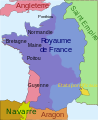 Gascony in 1328
 -
 Gascony in 1328 (English version)


Article(s): en:Battle of Winchelsea, en:Battle of Lunalonge, en:Battle of Auberoche, en:Hundred Years' War, en:Battle of Bergerac, en:Anglo-French War (1294–1303), en:Gascon campaign of 1345, en:Siege of Aiguillon and en:Lancaster's chevauchée of 1346.
- Request
- Can I get an English version of this map created please. The original creator has not been active since 2009.
Regards Newm30 (talk) 07:10, 13 December 2018 (UTC)
- Graphist opinion(s)
![]() Request taken by Goran tek-en (talk) 17:01, 15 December 2018 (UTC) @Newm30: You will have to provide me with the translation here, thanks. --Goran tek-en (talk) 17:01, 15 December 2018 (UTC)
Request taken by Goran tek-en (talk) 17:01, 15 December 2018 (UTC) @Newm30: You will have to provide me with the translation here, thanks. --Goran tek-en (talk) 17:01, 15 December 2018 (UTC)
- @Goran tek-en: - Thanks for picking this up.
Angleterre=England, Saint Empire=Holy Roman Empire, Normandie=Normandy, Bretagne=Brittany, Royaume de France=Kingdom of France, Guyenne=Gascony, États pontificaux=Papal State of Avignon. Ponthieu, Maine, Poitou, Navarre and Aragon are the same.Regards Newm30 (talk) 08:40, 16 December 2018 (UTC)- @Newm30: Draft 1, to be checked. --Goran tek-en (talk) 16:09, 16 December 2018 (UTC)
- @Goran tek-en: - Fantastic. The only update required is Flandres=Flanders. Regards Newm30 (talk) 02:01, 17 December 2018 (UTC)
- @Newm30: Draft 1, to be checked. --Goran tek-en (talk) 16:09, 16 December 2018 (UTC)
- @Goran tek-en: - Thanks for picking this up.
@Newm30: Now you can find it here file:Guyenne 1328-en.svg. If you are happy with this please put the code {{section resolved|1=~~~~}} on this request so it can be archived, thanks. ![]() Done --Goran tek-en (talk) 18:19, 17 December 2018 (UTC)
Done --Goran tek-en (talk) 18:19, 17 December 2018 (UTC)
- @Goran tek-en: Once again, thank you for your help in creating this file and the others I have previously requested. Your help is much appreciated. Regards Newm30 (talk) 00:50, 18 December 2018 (UTC)
- This section was archived on a request by: Newm30 (talk) 00:50, 18 December 2018 (UTC)
Map of Silverpit crater
File:Silverpitlocatormap.png used in featured articles of several Wikipedias, it'll be useful have a vectorize version easy to translate, regards!!! Ezarateesteban 22:43, 2 December 2018 (UTC)
- @Ezarate: It would be great if you use the "Make a new request" link at the top when you ask for something here. In that way we get all the code we need to work with it. In the way you have linked to the source it appears not to exist on commons, one way is to write like this
[[:file:Silverpitlocatormap.png]], file:Silverpitlocatormap.png, thanks. --Goran tek-en (talk) 12:32, 3 December 2018 (UTC)- I'm sorry, yes it's File:Silverpitlocatormap.png --Ezarateesteban 15:13, 3 December 2018 (UTC)
![]() Request taken by Goran tek-en (talk) 17:08, 15 December 2018 (UTC)
Request taken by Goran tek-en (talk) 17:08, 15 December 2018 (UTC)
- @Ezarate: Draft to look at. Please ping, thanks. --Goran tek-en (talk) 17:42, 16 December 2018 (UTC)
- @Goran tek-en: I think is ok, thanks Ezarateesteban 12:18, 18 December 2018 (UTC)
- @Ezarate: Now you can find it here file:Map of Silverpit crater.svg. If you are happy with this please put the code
{{section resolved|1=~~~~}}on this request so it can be archived, thanks. Done --Goran tek-en (
talk) 17:54, 18 December 2018 (UTC)
- @Ezarate: Now you can find it here file:Map of Silverpit crater.svg. If you are happy with this please put the code
- Thanks!!!! Ezarateesteban 18:11, 18 December 2018 (UTC)
- This section was archived on a request by: Ezarateesteban 18:11, 18 December 2018 (UTC)
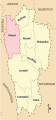
Limassol District
-
Description of first image
-
Description of second image (if needed)
-
Description of third image (if needed; don't request too many at once, though)
Article(s): [[]]
- Request
- Details of your request go here.
Hello. We have File:Cyprus limassol district.svg. I need a similar map, but the map must show the border of the communities. Like File:LimassolDistrict (1).png. I know the border coordinates. Can you help me? I have created File:LimassolDistrict2.svg but I don't know if it is really svg file like the rest location map, and there is no color. Xaris333 (talk) 18:00, 23 January 2018 (UTC)
Οκ. It working. The only problem is the colors. I want to have the same colors as the original not svg file. Xaris333 (talk) 19:42, 23 January 2018 (UTC)
- Graphist opinion(s)
Please use the "Make a new Request" (green) button/link at the top as it gives us all the code we need, thanks. --Goran tek-en (talk) 20:08, 25 January 2018 (UTC)
- This section was archived on a request by: Yann (talk) 20:07, 5 July 2018 (UTC)
Bad river name for early modern Europe map
-
 Europe, 1700—1714

Article(s): (none)
- Request
- Over Ukraine, we see a river labeled as Dniester. That's actually Southern Bug. Dniester is the next river to the left, at the border of Ukraine and Moldova. Can someone fix? --Gikü (talk) 21:48, 7 August 2018 (UTC)
- Graphist opinion(s)
@Gikü: Now there is a corrected version. If you are happy with this please put the code {{resolved|1=~~~~}} on this request so it can be archived, thanks. ![]() Done --Goran tek-en (talk) 18:09, 26 November 2018 (UTC)
Done --Goran tek-en (talk) 18:09, 26 November 2018 (UTC)
- This section was archived on a request by: Gikü (talk) 18:15, 26 November 2018 (UTC)
Germans attacks on Nauru-en.svg

Article(s): en:German attacks on Nauru
- Request
- Please correct two typos in Germans attacks on Nauru-en.svg
- Please change "Decembrer1940" to "December 1940" and "17 and 8 December" to "7 and 8 December" (Macedonian version also has this second error) --Davidships (talk) 18:24, 30 June 2018 (UTC)
- Graphist opinion(s)
![]() Done for English and Macedonian. De728631 (talk) 21:02, 2 August 2018 (UTC)
Done for English and Macedonian. De728631 (talk) 21:02, 2 August 2018 (UTC)
- This section was archived on a request by: BMacZero (talk) 21:03, 5 January 2019 (UTC)
Palestinian revolutionary flag
-

-
 Palestinian flag 1938


Article(s): en:1936–1939 Arab revolt in Palestine
- Request
- Can one of you add the crescent and the cross to the current Palestinian flag to conform to the Palestinian flag during the revolution. Like this flag.
- Details of your request go here… --Sakiv (talk) 00:40, 1 December 2018 (UTC)
- Graphist opinion(s)
- @Sakiv: Done KCVelaga (talk · mail) 15:20, 6 December 2018 (UTC)
- This section was archived on a request by: BMacZero (talk) 20:42, 5 January 2019 (UTC)
Update map for Internet access
-
 Internet access in percentage

Article(s): Many articles.
- Request
- This needs to be updated. The map is from 2012, which is prehistoric for Internet data. 2016 data is available in w:List of countries by number of Internet users. --Yann (talk) 16:58, 15 December 2018 (UTC)
- Graphist opinion(s)
- Request taken by BMacZero (talk) 19:57, 5 January 2019 (UTC)
- Done BMacZero (talk) 20:41, 5 January 2019 (UTC)
- This section was archived on a request by: BMacZero (talk) 20:41, 5 January 2019 (UTC)
Vermont
-
 SVG version of File:Vermont Municipal Map.png
 -
Description of second image (if needed)
-
Description of third image (if needed; don't request too many at once, though)

Article(s): [[]]
- Request
- SVG version of PNG map above. I'll use it to make a town by town map of the 2018 senate election in Vermont. --MB298 (talk) 07:03, 25 December 2018 (UTC)
- Graphist opinion(s)
- @MB298: Done File:Vermont Municipal Map.svg BMacZero (talk) 19:11, 5 January 2019 (UTC)
- This section was archived on a request by: BMacZero (talk) 19:11, 5 January 2019 (UTC)
SVG map for File:Esperanza de vida.PNG
-
 SVG map
 -
 PNG map


Article(s): Life expectancy
- Request
- Missing SVG map, please convert to SVG. --116.237.18.33 02:32, 1 April 2018 (UTC)
- Graphist opinion(s)
![]() Done I have also updated the map with reliable data from 2015. De728631 (talk) 17:59, 3 August 2018 (UTC)
Done I have also updated the map with reliable data from 2015. De728631 (talk) 17:59, 3 August 2018 (UTC)
- This section was archived on a request by: BMacZero (talk) 21:49, 6 January 2019 (UTC)
Mizoram district maps
-
 Saiha district
 -
 Serchhip district
 -
 Mamit district
 -
 Lunglei district
 -
 Lawngtlai district
 -
 Kolasib district
 -
 Aizawl district


Article(s): en:Saiha district, en:Serchhip district, en:Mamit district, en:Lunglei district, en:Lawngtlai district, en:Kolasib district, en:Aizawl district
- Request
- Please fix spelling Champai to Champhai in all as per district official name is en:Champhai district.-- Godric ki Kothritalk to me 12:45, 27 May 2018 (UTC)
- Graphist opinion(s)
- This section was archived on a request by: BMacZero (talk) 21:32, 6 January 2019 (UTC)
Free_State_of_Fiume


- Article(s)
- en:Free_State_of_Fiume
- Request
- Please make English version named File:Free_State_of_Fiume_1920-1924.png-the only names needing changed are "Italy" and "Yugoslavia"… --Kintetsubuffalo (talk) 01:46, 11 June 2018 (UTC)
- Graphist opinion(s)
@Kintetsubuffalo: ![]() Done, I've also cleaned up the JPEG artifacts that were present in the German source file. --Xerxes2k (talk) 21:21, 10 January 2019 (UTC)
Done, I've also cleaned up the JPEG artifacts that were present in the German source file. --Xerxes2k (talk) 21:21, 10 January 2019 (UTC)
- This section was archived on a request by: Xerxes2k (talk) 21:21, 10 January 2019 (UTC)
@Xerxes2k: Thank you so much for catching this!Kintetsubuffalo (talk) 05:29, 11 January 2019 (UTC)
Translate the file into Malay language
-
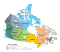 Image requested for translation (Political map of Canada.png)

Article(s): Provinsi dan wilayah di Kanada
- Request
- Hello. Can someone translate the image attached into Malay language (code lang: ms)? The translations are as follow:
- Canada – Political:
- → Kanada – Politik
- International boundary:
- → Sempadan antarabangsa
- Provincial/territorial boundary:
- → Sempadan provinsi/wilayah
- Province/territory:
- → Provinsi/wilayah
- National capital:
- → Ibu negara
- Provincial/territorial capital:
- → Ibu kota provinsi/wilayah
- Scale:
- → Skala
- Northwest Territories:
- → Wilayah Barat Laut
- Newfoundland and Labrador:
- → Newfoundland dan Labrador
- Prince Edward Island:
- → Pulau Putera Edward
- Thank you. 26 Ramadan (talk) 14:41, 1 June 2018 (UTC)
- Graphist opinion(s)
I will make a svg version so it will be easier to translate, ![]() Request taken by Goran tek-en (talk) 17:36, 2 February 2019 (UTC)
Request taken by Goran tek-en (talk) 17:36, 2 February 2019 (UTC)
- @26 Ramadan: Draft for you to check, ping me, thanks. --Goran tek-en (talk) 17:41, 7 February 2019 (UTC)
- @26 Ramadan: I really need your feedback per above to be able to complete this, ping me, thanks. --Goran tek-en (talk) 17:41, 15 February 2019 (UTC)
@26 Ramadan: I don't get any feedback/contact with the requester here so I upload it now. Now you can find it here file:Political map of Canada ms.svg. So I also put this as resolved for the above reason. :This section was archived on a request by: Goran tek-en (talk) 15:09, 21 February 2019 (UTC) ![]() Done --Goran tek-en (talk) 15:09, 21 February 2019 (UTC)
Done --Goran tek-en (talk) 15:09, 21 February 2019 (UTC)
Route of the chevauchée of Edward III in 1346
-
File:Map of route of Edward III's chevauchée of 1346.svg
Article(s): en:Chevauchée of Edward III (1346), en:Battle of Caen (1346), en:Battle of Blanchetaque, en:Battle of Crécy and en:Siege of Calais (1346–1347).
- Request
- I would like a map to be created of the route of the Chevauchée of Edward III through Northern France in 1346, based on this map. Battle markers will be needed at Caen, Blanchetaque (crossing of the Somme), Crécy and Calais. Regards --Newm30 (talk) 03:10, 23 December 2018 (UTC)
- Graphist opinion(s)
![]() Request taken by Goran tek-en (talk) 16:41, 23 February 2019 (UTC)
Request taken by Goran tek-en (talk) 16:41, 23 February 2019 (UTC)
- @Newm30: Draft-1 for you to check. Feedback and please ping me, thanks. --Goran tek-en (talk) 22:47, 26 February 2019 (UTC)
- @Goran tek-en: - Thanks again for picking up one of my requests. Much appreciated.
Could battle markers be placed next to Caen, Crécy and Calais? DoneCould battle marker and location "Blanchetaque" with date 24 August be placed at crossing of Somme between Crécy and Abbeville? DoneCan Seine be placed near river line east of Harfleur? DoneCan Somme be placed near river line south east of Abbeville? DoneCan Eure be placed near river line south west of Freneuse? DoneCan English channel be English Channel? DoneCan (Bay of the Seine) in small font be placed under Baie de la Siene? DoneCan Portsmouth be provided on the map with 11/12 July next to it and arrow from St.-Vaast-laHogue linked to Portsmouth? DoneCan St.-Vaast-laHogue be changed to St. Vaast la Hogue? Done
- Regards Newm30 (talk) 10:21, 27 February 2019 (UTC)
- @Newm30: Draft-2. I wrote 11-12 July instead as we used that format before, If you want the one you wrote just tell me. Also should not "Bay of the Seine" be the biggest one and "Baie de la Siene" smaller (if there at all) as the other two names of the Channel is in English?, thanks. --Goran tek-en (talk) 11:12, 27 February 2019 (UTC)
- @Goran tek-en: - Thanks very much for the fast response. I concur with "11-12 July". en:Baie de la Seine is the English wikipedia name of the article for the bay, so I that is why I thought Bay of the Seine underneath would clarify. Happy if you want to go with "Bay of the Seine" instead. Have struck through and marked as completed those that have been done. Please see couple outstanding. Thanks once again. Regards Newm30 (talk) 12:25, 27 February 2019 (UTC)
- @Newm30: Draft-3. --Goran tek-en (talk) 18:26, 27 February 2019 (UTC)
- @Goran tek-en: - Thank you very much for your very important input, excellent map creation skills and easy approach to my map requests. Your assistance and expertise is much appreciated and it is always a pleasure to work with you. The map is fantastic as usual and ready for upload into Wikispace. Regards Newm30 (talk) 09:00, 28 February 2019 (UTC)
- @Newm30: Thanks for that, you make it easy with your organized feedback, I will need the following;
- Name of the file
- Description
- Map of the route of Edward III's chevauchée of 1346, part of the Hundred Years' War. This map shows the English army movements during the campaign and the most important battles.
- Category/ies at commons
- to be able to upload it at commons. --Goran tek-en ([[User talk:Goran tek-en|
- @Goran tek-en: - Provided information above as requested. Sorry for the delay. Regards Newm30 (talk) 07:33, 6 March 2019 (UTC)
- @Newm30: Thanks for that, you make it easy with your organized feedback, I will need the following;
- @Goran tek-en: - Thank you very much for your very important input, excellent map creation skills and easy approach to my map requests. Your assistance and expertise is much appreciated and it is always a pleasure to work with you. The map is fantastic as usual and ready for upload into Wikispace. Regards Newm30 (talk) 09:00, 28 February 2019 (UTC)
- @Newm30: Draft-3. --Goran tek-en (talk) 18:26, 27 February 2019 (UTC)
- @Goran tek-en: - Thanks very much for the fast response. I concur with "11-12 July". en:Baie de la Seine is the English wikipedia name of the article for the bay, so I that is why I thought Bay of the Seine underneath would clarify. Happy if you want to go with "Bay of the Seine" instead. Have struck through and marked as completed those that have been done. Please see couple outstanding. Thanks once again. Regards Newm30 (talk) 12:25, 27 February 2019 (UTC)
- @Newm30: Draft-2. I wrote 11-12 July instead as we used that format before, If you want the one you wrote just tell me. Also should not "Bay of the Seine" be the biggest one and "Baie de la Siene" smaller (if there at all) as the other two names of the Channel is in English?, thanks. --Goran tek-en (talk) 11:12, 27 February 2019 (UTC)
- @Goran tek-en: - Thanks again for picking up one of my requests. Much appreciated.
talk]]) 13:27, 28 February 2019 (UTC) @Newm30: I need your input as per above, thanks. --Goran tek-en (talk) 11:06, 4 March 2019 (UTC)
- @Newm30: If you ever think I can help you it's OK to contact me direct. Now you can find it here file:Map of the route of Edward III's chevauchée of 1346.svg. If you are happy with this please put the code
{{section resolved|1=~~~~}}on this request so it can be archived, thanks. Done --Goran tek-en (talk) 14:10, 6 March 2019 (UTC) - This section was archived on a request by: Newm30 (talk) 09:50, 7 March 2019 (UTC)
Minor modifications to 2006 CIA Somalia base map
-
 2006 Somalia base map

Article(s): en:Somali Armed Forces
- Request
- Details of your request go here: Please modify https://commons.wikimedia.org/wiki/File:Somalia_pol02.jpg with two minor amendments; (1) change "Giohar" to "Jowhar" (en:Jowhar) as this is now the most common name; (2) insert a new location, Adado (en:Adado), in Galgaduud, about half way up the map. Please mark Adado in with a black dot, same style as Ceelbuur, on the road north of Dusa Marreb. The road from Dusa Marreb to Galcaio is basically in three bits; first one that bends slightly to the east, then it bends slightly to the west (bisected by the green dotted line west-east), and then it takes a hard almost 90% turn to the east again. Please mark in Adado half way up the second bit, the one bending to the west, which should be south of the green west-east line. Many thanks!! Buckshot06 (talk) 08:55, 11 February 2018 (UTC)
- Graphist opinion(s)
![]() Request taken by Goran tek-en (talk) 17:56, 16 March 2019 (UTC) New version is uploaded.
Request taken by Goran tek-en (talk) 17:56, 16 March 2019 (UTC) New version is uploaded. ![]() Done
Done I also mark this as resolved as it's so old and the user has no account here. :This section was archived on a request by: Goran tek-en (talk) 17:56, 16 March 2019 (UTC)
Geographical range of grey wolf and golden jackal together
-
 Blank map of Europe with subdivisions as template
 -
 Range of golden jackal (please ignore red dots)


Article(s): European jackal
- Request
- A map of Europe with overlapping ranges of grey wolf and golden jackal
- Have the wolf range in brown and the jackal range in dark yellow (something along these lines: File:Distribution of North American Canis.svg ). For an updated European wolf range map, see https://whyfiles.org/2014/europe-return-of-the-carnivores/index.html --Mariomassone (talk) 12:01, 18 February 2018 (UTC)
- Graphist opinion(s)
![]() Request taken by Goran tek-en (talk) 17:56, 2 February 2019 (UTC)
Request taken by Goran tek-en (talk) 17:56, 2 February 2019 (UTC)
- @Mariomassone: Draft for you to check, ping me, thanks. --Goran tek-en (talk) 19:10, 10 February 2019 (UTC)
- @Goran tek-en: It's perfect. Thank you! -Mariomassone (talk) 20:55, 10 February 2019 (UTC)
- @Mariomassone:
- I will need the following;
- Name of the file
- Description
- Category/ies at commons
- to be able to upload it at commons. --Goran tek-en (talk) 15:33, 11 February 2019 (UTC)
- @Goran tek-en: Grey wolf, golden jackal & African wolf ranges
- Ranges of Canis lupus, Canis aureus and Canis anthus in Mediterranean area
- Canis lupus distribution maps - Canis aureus moreotica - Canidae distribution maps - Canis anthus
- @Mariomassone:
- @Goran tek-en: It's perfect. Thank you! -Mariomassone (talk) 20:55, 10 February 2019 (UTC)
Mariomassone (talk) 08:53, 14 February 2019 (UTC)
@Mariomassone: Now you can find it here file:Grey wolf, golden jackal & African wolf ranges.svg. If you are happy with this please put the code {{section resolved|1=~~~~}} on this request so it can be archived, thanks. ![]() Done --Goran tek-en (talk) 17:36, 15 February 2019 (UTC)
I mark this as resolved now. :This section was archived on a request by: Goran tek-en (talk) 17:58, 16 March 2019 (UTC)
Done --Goran tek-en (talk) 17:36, 15 February 2019 (UTC)
I mark this as resolved now. :This section was archived on a request by: Goran tek-en (talk) 17:58, 16 March 2019 (UTC)
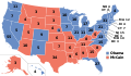
-
 2014 U.S. House election results
 -
 Global superpowers in 1945
 -
 Legality of Home schooling around the world


Article(s): en:United States House of Representatives elections, 2014, en:Superpower, en:Homeschooling in the United States
- Request
- Image #1: en:New Hampshire's 2nd congressional district is shaded as "Republican gain" even though the Democrat incumbent (en:Ann McLane Kuster) won re-election. Also, en:Illinois's 6th congressional district is shaded as "Democrat hold" even though the Republican incumbent (en:Peter Roskam) won re-election. These errors should be fixed.
- Image #2: The en:Aleutian Islands are shaded red (as though they are part of the USSR) even though they were (and are) part of the United States. This should be fixed.
- Image #3: The U.S. should be colored green on this map, as homeschooling is legal in all 50 states. What is disputed is not the legality of homeschooling, but the "amount of state regulation and help that can or should be expected", according to the article en:Homeschooling in the United States. --1990'sguy (talk) 15:45, 23 February 2018 (UTC)
- Graphist opinion(s)
- 1: Done by MB298
- 2: Done
- BMacZero (talk) 22:23, 6 January 2019 (UTC)
- 3: There seems to be a discussion about that map and it is marked "The factual accuracy of this map or the file name is disputed." and it seems to have many misstated areas so I think no one really knows what to do. --Goran tek-en (talk) 18:19, 17 March 2019 (UTC)
- This section was archived on a request by: Goran tek-en (talk) 18:19, 17 March 2019 (UTC)
Location map
-
 New administrative map of Nepal
 -
 Nepal relief location map


en:Province No. 1, en: Administration in Province No. 1
- Request
- Location map for Province No. 1 in Nepal.
- Need a location map for Province No. in Nepal, both adm. and relief. Also need location map for 14 districts in Province No. 1 of Nepal… --Raju Babu (talk) 17:42, 21 February 2018 (UTC)
- Graphist opinion(s)
? You asked me for a location map of Province No. 1 and I made it: Nepal Province No 1 adm location map.svg. NNW 20:31, 21 February 2018 (UTC)
- This map is okay, But may we not have a location map shaded province No. 1 in map of Nepal? You can draw a map of Nepal, in this map Nepal Province No 1 adm location map.svg on the top left corner. Raju Babu (talk) 02:39, 22 February 2018 (UTC)
- @Raju Babu: I'm trying to understand what you want. Is it a relief map of this area Nepal Province No 1 adm location map.svg? Please explain so I understand, I have zero knowledge of structure of provinces there, please ping me, thanks. --Goran tek-en (talk) 18:14, 17 March 2019 (UTC)
- @Raju Babu: If you want my help you will have to give me feedback on above, thanks. --Goran tek-en (talk) 16:02, 27 March 2019 (UTC)
- @Goran tek-en: I meant to say this map Nepal Province 1.svg, which is solved now. If you want to help me please draw adm. and rel. maps for Province No. 3, Gandaki Pradesh, Province No. 5 and Karnali Pradesh---Raju Babu (talk) 06:55, 30 March 2019 (UTC)
- @Raju Babu: If this was solved it should have been marked with
{{done}}{{section resolved|1=~~~~}}so it can be archived. Otherwise it's really hard for us who work here to know which request to attend to. So please do so and start a new request with your other needs, ping me there and I will help you but you will also have to provide me with sources I can use for the different adm. areas, thanks. --Goran tek-en (talk) 12:44, 30 March 2019 (UTC)- @Goran tek-en: I thought
{{done}}is marked by wikigraphists, so my attention was not on this.
- @Goran tek-en: I thought
- @Raju Babu: If this was solved it should have been marked with
- @Goran tek-en: I meant to say this map Nepal Province 1.svg, which is solved now. If you want to help me please draw adm. and rel. maps for Province No. 3, Gandaki Pradesh, Province No. 5 and Karnali Pradesh---Raju Babu (talk) 06:55, 30 March 2019 (UTC)
![]() Done :This section was archived on a request by: Raju Babu (talk) 13:50, 30 March 2019 (UTC)
@Raju Babu: I agree but that didn't work here. --Goran tek-en (talk) 15:30, 31 March 2019 (UTC)
Done :This section was archived on a request by: Raju Babu (talk) 13:50, 30 March 2019 (UTC)
@Raju Babu: I agree but that didn't work here. --Goran tek-en (talk) 15:30, 31 March 2019 (UTC)
South Sudan (and if it is also missing, Montenegro) urgently needs to be included in these blank world maps
-
 File:Blank map world gmt.pdf Done
 -
 File:Blank map world gmt (simplified).svg Done
 -
 File:Blank map world gmt (more simplified).svg Done
 -
 File:BlankMap - World - Hellerick polynomial continent-based projection.svg Done
 -
 File:BlankMap-World.svg Already Done
 -
 File:BlankMap-World-162E-flat.svg Done
 -
 File:BlankMap-World-180E.svg Done
 -
 File:BlankMap-World-90W.svg Done
 -
 File:BlankMap-World-large2.png Done
 -
File:BlankMap-World.svg This was alredy Done
-
 File:BlankMap-World5.svg Done
 -
File:BlankMap-World.svg This was alredy Done
-
File:BlankMap-World.svg This was alredy Done
-
 File:NED worldmap 110m.svg Done
 -
 File:World map (Miller cylindrical projection, blank).svg Done
 -
 File:World map - low resolution chain test.svg Done
 -
 File:World Map Blank.svg Done
 -
 File:World map blank with blue sea.svg Done
 -
 File:World map nations.svg Done
 -
 File:World pacific 0001.svg Done
 -
 File:Worldmap-blank.svg Done
 -
 File:World V2.0.svg Done
.svg)
.svg)


.svg)


-
 File:Africa mapa mudo.png Done
 -
 File:Blankmap-Africa2.png Done
 -
 File:SVG-Koort Afrika.svg Done


-
 File:Asia in Th.png Nothing to update here. Done
 -
 File:Asia location map.svg Done
 -
 File:Asia location map2.svg Done
 -
 File:Asie.svg Nothing to update here. Done
 -
 File:Les pays asiatiques - Blank.svg Done
 -
 File:Location Map Asia.svg Nothing to update here. Done


Article(s): Many
- Request
- South Sudan (and if it is also missing, Montenegro) urgently needs to be included in these blank world maps, because many users create and upload new maps based on these obsolete maps, without realizing this. Updating all these maps will spare time consuming border changes in the future (and also if new countries become independent in the future). The maps are based on de-jure borders. (I am adding South Sudan (as well as Montenegro and other possible missing updates) in the PNG maps in Category:Maps needing South Sudan political boundaries and then remove this category after updating them. There were close to 1100 maps since I started to update these files, now it is reduced to less than 800 maps, but there is a very long way to go and it is very time consuming and almost never ending, as there are very likely many more unlabeled maps.) --Maphobbyist (talk) 13:37, 10 March 2018 (UTC)
- Graphist opinion(s)
- There's a template for that: {{update|South Sudan}}. I'd recommend adding this to these maps (and any others). I've also noticed that some of these maps have 'South Sudan' mentioned in the file changes; have you checked that these maps need updating prior to putting them in the gallery? Gringer (talk) 21:55, 12 March 2018 (UTC)
@Maphobbyist: I will help with this but I can't tell how many or when. --Goran tek-en (talk) 21:31, 5 March 2019 (UTC)
![]() Done :This section was archived on a request by: Goran tek-en (talk) 15:38, 12 April 2019 (UTC)
Done :This section was archived on a request by: Goran tek-en (talk) 15:38, 12 April 2019 (UTC)
Borders of South Sudan
-
 1st Map
 -
 2nd Map
 -
 3rd Map
 -
 4th Map
 -
 Borders of South Sudan


Article(s): Several
- Request
- Can you please add the Borders of South Sudan in the 1st, 2nd, 3rd, and 4th Maps --باسم (talk) 09:55, 1 April 2018 (UTC)
- Graphist opinion(s)
![]() Request taken by Goran tek-en (talk) 15:40, 12 April 2019 (UTC)
Request taken by Goran tek-en (talk) 15:40, 12 April 2019 (UTC)
- @باسم: Updated and if you are happy with this please put the code
{{section resolved|1=~~~~}}on this request so it can be archived, thanks. Done --Goran tek-en (talk) 17:04, 12 April 2019 (UTC)
- @Goran tek-en: thank you so muchباسم (talk) 17:09, 12 April 2019 (UTC)
- This section was archived on a request by: باسم (talk) 17:09, 12 April 2019 (UTC)
Physical map of Peru, with source for the underlying topographical information
-
Description of first image
-
Description of second image (if needed)
-
Description of third image (if needed; don't request too many at once, though)
Article(s): en:Ubinas
- Request
- A physical map of Peru.
- Basically, the same content as File:Peru physical map.svg but from a clearly stated source for the topographic information, as File:Peru physical map.svg states no source and unsourced maps are inadequate for certain enwiki processes. Summoning also Urutseg. --Jo-Jo Eumerus (talk) 07:04, 27 August 2018 (UTC)
- In respond to summon: Jo-Jo Eumerus, all my maps are made using en:SRTM data v3. I'm not active anymore, so if something needs changing, feel free to do it.--Urutseg (talk) 16:53, 8 September 2018 (UTC)
- Graphist opinion(s)
![]() Request taken by Goran tek-en (talk) 17:45, 12 April 2019 (UTC)
@Jo-Jo Eumerus: Draft for you. The finished file will be heavy (in Mb) but not as heavy as this draft, please ping me, thanks. --Goran tek-en (talk) 14:36, 14 April 2019 (UTC)
Request taken by Goran tek-en (talk) 17:45, 12 April 2019 (UTC)
@Jo-Jo Eumerus: Draft for you. The finished file will be heavy (in Mb) but not as heavy as this draft, please ping me, thanks. --Goran tek-en (talk) 14:36, 14 April 2019 (UTC)
- @Goran tek-en: Seems like the issue in enwiki was resolved, but thanks. That seems fairly heavily stylized, though. Jo-Jo Eumerus (talk) 15:58, 14 April 2019 (UTC)
![]() Done Then I mark this as :This section was archived on a request by: Goran tek-en (talk) 15:00, 15 April 2019 (UTC)
Done Then I mark this as :This section was archived on a request by: Goran tek-en (talk) 15:00, 15 April 2019 (UTC)
Political divisions of Mexico 1865
-

-

-

-

-
 Option 1


.svg)
_in_Mexico.svg)
Article(s): es:Segundo Imperio Mexicano
- Request
- I request an SVG map of the political territorial division of the Second Mexican Empire (1865) with the map design "option 1". If possible, also add some lines to compare the territorial limits of 1865 with the current ones
- Details of your request go here… --Wiki-1776 (talk) 23:13, 7 June 2018 (UTC)
- Just as a note, I'm still interested in my request. Hispano76 (talk) 20:13, 17 March 2019 (UTC)
- Graphist opinion(s)
@Hispano76: You have to be more specific I/we don't know anything about this subject. Provide source and what you want, not a lot of information around, thanks. Please ping me. --Goran tek-en (talk) 17:29, 12 April 2019 (UTC)
- Goran tek-en Well, I'm redoing the request in the hope of clearing it up.
- I ask for a SVG from this map but one that only has the proposed 1865 boundaries and not the current territorial division. In other words, remove the "grey" lines from the map and make the dotted lines "long".
- Another clarification, I want you to allow that this map can be "colored", that is in case there is interest in making a population statistic with the table of this web page, something similar to this European map (Example).
- I hope you have understood me, my apologies if this is not the case. Hispano76 (talk) 20:30, 14 April 2019 (UTC)
- Request taken by Goran tek-en (talk) 15:56, 15 April 2019 (UTC)
- @Hispano76: Thank you, now I understand, great. --Goran tek-en (talk) 15:56, 15 April 2019 (UTC)
- @Hispano76: Now there is a draft for you to check. All the different areas are divided as the division borders. I have also (just for this draft) colored areas and island with a temporary line around so you can tell me where the different islands belongs. Give me feedback, do you want names or anything else just tell me thanks. --Goran tek-en (talk) 10:09, 23 April 2019 (UTC)
- @Goran tek-en: Thank you very much, I like the way it looks.
- According to the website I linked to, all the lines to your department are correct. Only the islands of the Orange line are not mentioned on the website but I could assume it belongs to Autlan because of the proximity. Or we can leave it "blank" until there are sources to clarify this.
- About your second question. You could make another map with the names of the departments if you like, so you would have two, a map with the divisions and the names of the departments and another with only the territorial divisions. What do you say? Hispano76 (talk) 16:35, 23 April 2019 (UTC)
- @Hispano76: Here is two different drafts, is this what you mean?
- Draft borders.
- Draft names, you should check all the names, thanks. --Goran tek-en (talk) 13:54, 24 April 2019 (UTC)
- @Goran tek-en: The first image looks good.
- The second map, the names of the entities are not well visualized because they are intercut (Tulacingo..) and the territorial division is not visualized, perhaps it would be good that instead of having names intercut, they were numbers as it was done with these maps or the second option is that they have different size of letter and they are in horizontal order, vertical or etc, something similar to this other map. At first glance, there doesn't seem to be any misplacement with the names.
- But I also leave you free to decide to do it or leave it as it is. You'll say. Anyway I thank you very much for your great work. Hispano76 (talk) 16:06, 24 April 2019 (UTC)
- @Hispano76: I don't understand what you mean by "intercut (Tulacingo..) and the territorial division is not visualized".
- Is it that the words are on two lines to be able to fit?
- What is not visualized, is it not the correct borders?
- I agree that there is to much text so I will do a version. --Goran tek-en (talk) 16:57, 24 April 2019 (UTC)
- @Hispano76: I don't understand what you mean by "intercut (Tulacingo..) and the territorial division is not visualized".
- @Hispano76: Here is two different drafts, is this what you mean?
- @Goran tek-en: I'm sorry, he used a translator and he did it wrong. I wanted to say "[words] cut off that don't visualize well with territorial divisions". Hispano76 (talk) 17:22, 24 April 2019 (UTC)
- @Hispano76: Draft with numbers. --Goran tek-en (talk) 17:48, 24 April 2019 (UTC)
- @Goran tek-en: I like the way it looks, thank you. I propose you name them as Political divisions of Mexico 1865.svg y Political divisions of Mexico 1865 (numbers).svg. Description may be "Mexico Territorial Division of 1865/División Territorial de México de 1865. Category: Maps of the Mexican Empire, SVG maps of the history of Mexico, Territorial evolution of Mexico. What do you say? Hispano76 (talk) 18:07, 24 April 2019 (UTC)
- @Hispano76: I guess that the second language is Spanish so I used that for the descriptions and also I added Captions. If you don'y know about Caption read here.
- Now you can find them under your names.. If you are happy with this please put the code
{{section resolved|1=~~~~}}on this request so it can be archived, thanks. Done --Goran tek-en (talk) 14:18, 25 April 2019 (UTC)
- @Hispano76: I guess that the second language is Spanish so I used that for the descriptions and also I added Captions. If you don'y know about Caption read here.
- @Goran tek-en: I like the way it looks, thank you. I propose you name them as Political divisions of Mexico 1865.svg y Political divisions of Mexico 1865 (numbers).svg. Description may be "Mexico Territorial Division of 1865/División Territorial de México de 1865. Category: Maps of the Mexican Empire, SVG maps of the history of Mexico, Territorial evolution of Mexico. What do you say? Hispano76 (talk) 18:07, 24 April 2019 (UTC)
- @Hispano76: Draft with numbers. --Goran tek-en (talk) 17:48, 24 April 2019 (UTC)
- This section was archived on a request by: Hispano76 (talk) 14:23, 25 April 2019 (UTC)
Map for the "Cultural Triangle" in Sri Lanka
Article(s): en:Cultural triangle
- Request
- The "Cultural triangle" is literally a triangle between the cities of Anuradhapura/Polonnaruwa/Kandy in Sri Lanka.
- Would anyone be kind enough to create a map showing this, or let me know how to do? With Inkscape I added a red triangle over a screenshot of OpenStreetMap, but the result is not great because the 3 city names are not all visible, and labels of unrelated smaller cities add to the mess. Thanks! :-) --Syced (talk) 07:59, 6 December 2018 (UTC)
- Graphist opinion(s)
![]() Request taken by Goran tek-en (talk) 17:53, 26 April 2019 (UTC)
Request taken by Goran tek-en (talk) 17:53, 26 April 2019 (UTC)
@Syced: Draft for you to check, feedback, thanks, --Goran tek-en (talk) 10:11, 28 April 2019 (UTC)
- @Goran tek-en: : Looks great! Would you mind adding the cities Sigiriya and of Dambulla too? Thanks a lot :-) Syced (talk) 07:18, 29 April 2019 (UTC)
- @Syced: Draft 2 and if this is okayI will need the following;
- Name of the file
- Description (language)
- Captions/s (language/content)
- Category/ies at commons
- to be able to upload it at commons. If you don'y know about Captions read here.--Goran tek-en (talk) 16:13, 29 April 2019 (UTC)
- @Goran tek-en: Perfect thanks!
- Name: Sri Lanka’s Cultural triangle
- Description (English): Situated in the centre of the island, covering an area which includes the World Heritage cultural sites of the Sacred City of Anuradhapura, the Ancient City of Polonnaruwa, the Ancient City of Sigiriya, the Ancient City of Dambulla and the Sacred City of Kandy.
- Caption (English): Sri Lanka’s Cultural triangle
- Categories: Maps of Sri Lanka, Culture of Sri Lanka
- Thanks! Syced (talk) 18:21, 30 April 2019 (UTC)
- @Syced: Draft 2 and if this is okayI will need the following;
@Syced: Now you can find it here file:Sri Lanka’s Cultural triangle.svg. If you are happy with this please put the code {{section resolved|1=~~~~}} on this request so it can be archived, thanks. ![]() Done --Goran tek-en (talk) 12:39, 1 May 2019 (UTC)
Done --Goran tek-en (talk) 12:39, 1 May 2019 (UTC)
- Wonderful, thanks! :-) Syced (talk) 06:29, 3 May 2019 (UTC)
- This section was archived on a request by: Goran tek-en (talk) 17:06, 22 May 2019 (UTC)
Divide blank world map with subdivisions by continents
-
 Blank Map of the World
 -
 example/style 1
 -
 example/style 2
 -
 Example/style 3

_(special_marker)_(-mini_map_-rivers).svg)


Article(s):
- Request
- Hola estimados, quiero pedirles que dividan el mapa por continentes con uno de los dos estilos (style 1 o style 2 o 3) para que puedan verse mejor el mapa y más cerca. Sería útil para algunos artículos que existen. Al menos lo pido para Norteamerica (que incluido Centroamerica y el Caribe además de Groenlandia y Hawaii) porque hay otro similar pero siempre le falta uno que otro "territorio". Pueden hacerlo PNG o SVG, como gusten-
- Is there news? --189.230.76.133 14:30, 18 March 2018 (UTC)
- Details of your request go here… --189.238.82.187 01:35, 5 November 2017 (UTC)
- Graphist opinion(s)
I don't know how many speak Spanish (I think it is) here but no one has taken this and I don't know how to contact the requester. --Goran tek-en (talk) 17:58, 17 March 2019 (UTC)}}
- Goran tek-en Hello, I am interested in this request
A translation would be:
"Hello estimates, I would like to ask you to divide the map by continents with one of the two styles (style 1 or style 2 or 3) so that the map can be seen better and closer. It would be useful for some existing articles. At least I ask for North America (which includes Central America and the Caribbean as well as Greenland and Hawaii) because there is another similar one but it always lacks one or another "territory". You can do it PNG or SVG, as you like." Hispano76 (talk) 20:11, 17 March 2019 (UTC)
![]() Request taken by Goran tek-en (talk) 14:15, 18 March 2019 (UTC)
Request taken by Goran tek-en (talk) 14:15, 18 March 2019 (UTC)
@Hispano76: I can help you but first we have to check some things.
- Have you searched commons to see what already exist, if not please do so.
- If we will do new ones: Do you want just country borders or also "landscape/area" borders like in this file:World blank map.png
It will be really really hard to know which are correct and up to date, and to find an accurate source in svg. Please ping me, thanks. --Goran tek-en (talk) 14:15, 18 March 2019 (UTC)
- Goran tek-en
- 1) I didn't find an existing image for this.
- 2) Only territorial borders Hispano76 (talk) 17:11, 18 March 2019 (UTC)
@Hispano76: If you look here;
- Locator_maps_of_continents and all its subcategories/subsubcategories etc you will find a lot.
- SVG_locator_maps_of_continents_(globe_scheme)
- or just search like this continents
- Please get back to me any way, if you find what you want or not. There are so many ways to depict them so if you need new ones we have to define that, thanks. --Goran tek-en (talk) 14:03, 19 March 2019 (UTC)
- @Hispano76: I need your feedback on the things above, ping me, thanks. --Goran tek-en (talk) 17:43, 25 March 2019 (UTC)
- Do these designs work?
- Canada
- United States
- Mexico
- Guatemala
- Belize
- Honduras
- El Salvador
- Nicaragua
- Costa Rica
- Panama
- Cuba
- Jamaica
- Bahamas
- Puerto Rico
- Greenland
- Haiti
- Dominican Republic
- Lesser Antilles
- Goran tek-en Hispano76 (talk) 19:08, 25 March 2019 (UTC)
- @Hispano76: I think we misunderstand each other. You put a lot of links to maps with administrative divisions and I don't understand why. You wrote before only "Only territorial borders" so why those links?
- If you checked the links I gave you before and the maps you want can't be found there I have to understand what you want.
- Do you want each continent alone on it's own map without the rest of the world?
- Do you want each continent viewed as straight on as possible? E.a. Antarctic is often showed at the bottom of a map and not straight on.
- Do you want each continent alone on it's own map without the rest of the world?
- Like in this map were it's mostly Africa which is shown straight on, the rest at different angels.
- I have to understand so I don't do a lot of work for nothing. --Goran tek-en (talk) 19:50, 25 March 2019 (UTC)
- @Hispano76: I think we misunderstand each other. You put a lot of links to maps with administrative divisions and I don't understand why. You wrote before only "Only territorial borders" so why those links?
- Goran tek-en Hispano76 (talk) 19:08, 25 March 2019 (UTC)
- um, he had actually written a text re-explaining what the ip was looking for and what the ip is looking for, but apparently the new code editor 2017 deleted that part... I explain again and apologize. Goran tek-en
- I think you misunderstood me or I didn't make myself understood. What I and the ip are looking for is a map of the state/provincial subdivisions of nations by continent similar to these three maps of Europe. But for the continents of South America, North America with Central America and the Caribbean included, Asia, Africa, Oceania and Europe.
- Although my priority (and I don't know the ip... :/) would be to have a map of the territorial subdivisions of North America that includes the Caribbean and Central America as well as Hawaii and Greenland. I already linked several maps of the subdivisions by country, it could be used as a reference to create a continental map of territorial subdivisions. Do you understand me?
- Postscript: South America is another priority. Hispano76 (talk) 18:39, 26 March 2019 (UTC)
- @Hispano76: Thanks for explaining to me. Most maps have different projections so to move borders/territorial subdivisions from one map onto another is often an impossible task. Even those two Canada, United States are different and not possible to join together for a whole map. So I think the best way would be if someone who knows how to work with datasets/gis or something could do this. I don't have that knowledge.
- I'm trying another way but it means a great deal of work for me but I will try it on North America and then we will see. So I will be back in a while with a draft. --Goran tek-en (talk) 18:04, 27 March 2019 (UTC)
- @Hispano76: When I make a map I design it so that it will be legible at 100%, this is the only size I have some control over. I can never design one map so it will be legible at many different sizes. As I said before this is really complicated as there are countries with so big differences in sizes of it's administrative divisions and then it's almost impossible to join different maps. So it's a big complicated map both to make but also to take part of. I hope you have a good idea of how to use it as to my understanding it will be hard.
- All sources for Greenland were very different in projection compared with my base map so I had to guess a bit there.
- Draft-1 for you to check, give me feedback, thanks. --Goran tek-en (talk) 17:32, 7 April 2019 (UTC)
- Goran tek-en I understand. On the map it seems good to me, I could opt for this design instead of looking for another one. As for its use, I had thought of making examples of population density at the state level, entities that have already had a woman in the position of state executive power, etc. You could fix it or make a second version so that different colors can be added. I'm sorry if I seem demanding. Hispano76 (talk) 18:02, 7 April 2019 (UTC)
- @Hispano76: I don't understand what you mean by this "I could opt for this design instead of looking for another one." specially the word "opt".
- So to see if I understand you;
- This draft is okay for you and could be some kind of "empty base map". I will then need the following;
- Name of the file
- Description
- Category/ies at commons to be able to upload it at commons.
- You want another version were some divisions have different colors. It would have been god to know this before as many of the divisions are not an area by itself, in fact I have removed such areas as the had no use for the purpose you gave me before. It can be done but also this part can be extensive depending on how many it is.
- You want another version were some divisions have different colors. It would have been god to know this before as many of the divisions are not an area by itself, in fact I have removed such areas as the had no use for the purpose you gave me before. It can be done but also this part can be extensive depending on how many it is.
- You have to provide me with sources and maps are easier for me, not names of divisions. Get that and I will look at it, thanks. --Goran tek-en (talk) 14:10, 8 April 2019 (UTC)
- @Hispano76: I don't understand what you mean by this "I could opt for this design instead of looking for another one." specially the word "opt".
- Goran tek-en I understand. On the map it seems good to me, I could opt for this design instead of looking for another one. As for its use, I had thought of making examples of population density at the state level, entities that have already had a woman in the position of state executive power, etc. You could fix it or make a second version so that different colors can be added. I'm sorry if I seem demanding. Hispano76 (talk) 18:02, 7 April 2019 (UTC)
- @Hispano76: When I make a map I design it so that it will be legible at 100%, this is the only size I have some control over. I can never design one map so it will be legible at many different sizes. As I said before this is really complicated as there are countries with so big differences in sizes of it's administrative divisions and then it's almost impossible to join different maps. So it's a big complicated map both to make but also to take part of. I hope you have a good idea of how to use it as to my understanding it will be hard.
- @Hispano76: Thanks for explaining to me. Most maps have different projections so to move borders/territorial subdivisions from one map onto another is often an impossible task. Even those two Canada, United States are different and not possible to join together for a whole map. So I think the best way would be if someone who knows how to work with datasets/gis or something could do this. I don't have that knowledge.
- Yes, is okay.
- Name of the file: File:North America, administrative divisions.svg
- Description: Map of North America with subdivisions at the state level. / Mapa de Norteamérica con las subdivisiones a nivel estatal.
- Category/ies: Category:SVG labeled maps of administrative divisions of countries of North America (location map scheme) or Category:SVG labeled maps of administrative divisions of North America (location map scheme)
- About that, I wanted something like this map of Europe but I no longer understood what you meant by other sources and maps, in that part I was confused, must be by my lack of experience in this. I'm sorry. Although I have reviewed the file, it seems that entities such as Alaska can be "colored" as long as they do not have intermediate lines such as rivers. But the colors are down 30-70%. Perhaps by simply removing the geographical boundaries, it can be solved and colored. Anyway, this wouldn't be urgent and you can take your time. Hispano76 (talk) 21:16, 9 April 2019 (UTC)
- @Hispano76: Now you can find it here file:North America, administrative divisions.svg. In some way you have to tell which areas to color and if any are the same, what you want to show. You can make print screens of the uploaded file (or download a png) and then put colored dots in the different areas you want colored and provide me with it. --Goran tek-en (talk) 18:27, 11 April 2019 (UTC)
- Thank you very much. I'll check it out. Greetings. Hispano76 (talk) 19:45, 12 April 2019 (UTC)
- @Hispano76: Now you can find it here file:North America, administrative divisions.svg. In some way you have to tell which areas to color and if any are the same, what you want to show. You can make print screens of the uploaded file (or download a png) and then put colored dots in the different areas you want colored and provide me with it. --Goran tek-en (talk) 18:27, 11 April 2019 (UTC)
![]() Done
Done
@Hispano76: Is this done? If so please put the code {{section resolved|1=~~~~}} on this request so it can be archived, or get back to me with what you need, thanks. --Goran tek-en (talk) 11:38, 29 May 2019 (UTC)
- At the moment, I have no further requests regarding this request. Greetings. Hispano76 (talk) 16:04, 29 May 2019 (UTC)
- This section was archived on a request by: Hispano76 (talk) 16:04, 29 May 2019 (UTC)
Right-wing populist parties in Europe, Dec. 2017
-
 Right-wing populist parties in Europe, December 2017
.png)
Article(s): en:Right-wing populism
- Request
- Please shade the UK light blue. As I stated when I requested the Oct. 2017 map be fixed, the en:Democratic Unionist Party is in the parliament and supports the Conservative Party government. The DUP is a right-wing populist party (see here -- source: Ingle, Stephen (2008). The British Party System: An Introduction. Routledge. p. 156.). Also, some factions of the Conservative Party (including some MPs) are right-wing populist.[2]
- Also, maybe Iceland should also be shaded light blue. Since the en:Icelandic parliamentary election, 2017 (held in late-October 2017), two parties that are arguably right-wing populist, the en:People's Party (Iceland, 2016)[3][4] and the en:Centre Party (Iceland), were first elected to the parliament. Most of what I read labels these parties simply as "populist", but both of these parties lean on the right, at least on issues related to nationalism and immigration, and right-wing populism is increasingly being labeled as simply "populism." This isn't as important as my first request, but I think it should still be done. --1990'sguy (talk) 04:10, 6 March 2018 (UTC)
- Graphist opinion(s)
- This map needs more reliable sources in the first place. The only source attributed in the description is Parties and Elections in Europe which does not even label some of the parties mentioned in the map as right-wing populism. Add to that that it appears to be a one-man self-published website. I'd agree with your analysis of the UK though, but this Icelandic source doesn't look very reliable to me. De728631 (talk) 00:45, 5 August 2018 (UTC)
Greater Armenia

- Article(s)
- en:Greater Armenia
- Request
- please overlay other landmarks like the Caspian or Black Sea, for context… --Kintetsubuffalo (talk) 14:04, 5 April 2018 (UTC)
- Graphist opinion(s)
Saint Pierre and Miquelon
- Article(s)
- en:Saint Pierre and Miquelon
- Request
- please create closeup map of the islands in relation to Newfoundland. The article has two long-distance maps which show them as specks… --Kintetsubuffalo (talk) 14:04, 5 April 2018 (UTC)
- Graphist opinion(s)
Create a map using gpx data
Hello. I have a gpx file with communities border of my country. Anyone can help me to use it to create a map? Xaris333 (talk) 01:04, 27 August 2018 (UTC)
- @Xaris333: Just search internet for "Create a map using gpx data" and you will find information on how to. --Goran tek-en (talk) 14:39, 12 November 2018 (UTC)
- It was the first I did. No useful results. Xaris333 (talk) 16:30, 12 November 2018 (UTC)
- @Xaris333: Here you can upload a file and choose output, more options here. Qgis is a free program that has a plug in gpxsomething wich also work, here. List of websites. You can also go this way, it also depends on what kind of output you want. --Goran tek-en (talk) 17:12, 12 November 2018 (UTC)
- It was the first I did. No useful results. Xaris333 (talk) 16:30, 12 November 2018 (UTC)
Map of Limosa lapponica subspecies
-
 Map of Limosa lapponica subspecies migration routes
- Request
- Merge L. l. anadyrensis map into L. l. baueri map as one map, under the latter name (synonymy [scroll ¾ down linked page for details])
- Rearrange maps geographically, rather than alphabetically, so left to right in this order:
- L. l. lapponica
- L. l. taymyrensis
- L. l. menzbieri
- L. l. baueri
- MPF (talk) 14:54, 12 September 2018 (UTC)
- Graphist opinion(s)
Requesting a version of this particular map with subdivisions such as states and oblasts and etc.
-
Somebody please make this map but with subdivisions
Article(s): Since the image isn't working here's the link to its wikipedia page!
- Request
- I can't seem to find the above map ANYWHERE when I upload it to google image search, and unfortunately its not the simple 1-px-wide border system but national borders of varying size and pattern, and I'm simply not skilled or do not have the right equipment available to be able to expand said map down into the sub-national sub-divisions. Thanks! --Abbazorkzog (talk) 00:16, 25 November 2018 (UTC)
- Graphist opinion(s)
@Abbazorkzog: I don't really understand what you are looking for but have you checked out this category with blank world maps. Don't forget to look in all the subcategories also. --Goran tek-en (talk) 14:28, 29 November 2018 (UTC)
2 maps of Argentina
-
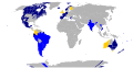 1. Color Tierra del Fuego
 -
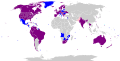 2. Change color of Buenos Aires and Rosario


- Request
- Color Tierra del Fuego Province the same color the rest of Argentina, as the ban is the whole country
- Change color of Buenos Aires and Rosario, Argentina, to Purple - Sexual orientation and gender identity: all employment
--Yilku1 (talk) 16:53, 22 December 2018 (UTC)
- Graphist opinion(s)
- @Yilku1: Done BMacZero (talk) 19:27, 5 January 2019 (UTC)
- There is a mistake in N.2, the cities of Buenos Aires and Rosario should be purple "Sexual orientation and gender identity: all employment" --Yilku1 (talk) 00:32, 10 January 2019 (UTC)
Create Luzon locator maps
-
Description of first image
-
Description of second image (if needed)
-
Description of third image (if needed; don't request too many at once, though)
Article(s): More zoomed in locator maps for Luzon.
- Request
- Locator maps for Luzon
- Additional locator maps for Luzon, as is the most populated island, which means there are more points of interest here than elsewhere in the Philippines.
- Mega Manila, 40 km radius from Manila City Hall. (A more zoomed out version of Metro Manila location map.svg.
- Northern Luzon, from Batanes to the southern tip of Bataan.
- Southern Luzon, from the northern tip of Quezon to Masbate
- Philippines location map (Luzon).svg can be used. The three maps do overlap, and there's no need for other parts of the country to be grayed out.
Howard the Duck (talk) 02:36, 29 December 2018 (UTC)
- Graphist opinion(s)
Lamu
- Article(s)
- en:Lamu
- Request
- the map Funguvisiwa vya Lamu.png at https://sw.wikipedia.org/wiki/Funguvisiwa_ya_Lamu#/media/File:Funguvisiwa_vya_Lamu.png may not be allowable here, but the size and detail are great. please make free-use Commons-friendly version … --Kintetsubuffalo (talk) 01:45, 11 June 2018 (UTC)
- Graphist opinion(s)
@Kintetsubuffalo: Why would it not be allowed here, it's from Open Street Map, as long as credits are given I can't see any problem. --
- Then can you bring it to Commons, my unsigned friend?Kintetsubuffalo (talk) 05:08, 5 February 2019 (UTC)
Location maps Norway
-
 Sortland Municipality
 -
 Kvæfjord Municipality
 -
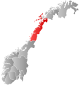 Nordland County
 -
 Troms County


Request:
@Jon Harald Søby: , @Marmelad: These maps (and possibly others?) need to be updated. Godfjorden in Kvæfjord became part of Sortland in 2000. Blue Elf (talk) 19:52, 25 May 2018 (UTC)
- Comment: Where is the source? I don’t see mention of Scotland in either article.
- Comment: The gradient is confusing, nonstandard, and unaesthetic. A lot of locator maps for Norway will correspondingly need to be changed. –LaundryPizza03 (dc̄) 05:55, 16 July 2019 (UTC)
Maps of Poland, Russia and Lithuania
Article(s): en:Kingdom of Poland, en:Kievan Rus', Polish-Lithuaninan Commonwealt, Russian Empire, Muscovy...
- Request
- I don't know source of these maps, it might be still under copyright. It would be nice if we could have free SVG alternatives
- Details of your request go here… -- Bojan Talk 03:01, 28 May 2018 (UTC)
- Graphist opinion(s)
 Deleted per Commons:Deletion requests/Files uploaded by DrMako. –LaundryPizza03 (dc̄) 15:13, 16 July 2019 (UTC)
Metrication by year
-
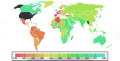 World Map showing metrication
 -
 Correct palette/South Sudan boundaries


Article(s): Metrificación, Sistema internazionale di unità di misura and many others
- Update map and friendly coloring
- A lot of work here. It is supposed to be the "replacement map" for metrication pages; nevetheless it has a lot of issues. There are no South Sudan boundaries; the color palette isn't the best for visually impaired people. I'm not good at all at Perl and similar, could you help me? The palette is shown in the second image.--Carnby (talk) 18:04, 28 January 2018 (UTC)
- Graphist opinion(s)
Note: Argentina adopted the metre in 1863, not in the 1880s.--Yilku1 (talk) 16:41, 22 December 2018 (UTC)
- The corrections and updates made in File:Metrication by year map.svg must also be applied in File:World metrication.svg which has numerous countries left as uncategorized and blank.
Biome of Australia
-
 This the Temperate broadleaf and mixed forests biome.
 -
 Mediterranean Forests, woodlands and scrub biome.


Article(s):
- en:Mediterranean forests, woodlands, and scrub
- en:Temperate broadleaf and mixed forest
- en:Tropical and subtropical dry broadleaf forests
- Request
- As per these sources ([5] - or jump to its map link - and [6]), it is quite clear that most of eastern Australia, besides a few spots, are not under the temperate forest biome. Sydney, for instance, mostly has dry sclerophyl and a few wet sclerophyl places, just akin to Adelaide and Perth. Therefore, it will be more appropriate for the region of Sydney to be under the Mediterranean biome. Furthermore, as you can see from these maps I provided, there are small pockets of temperate and subtropical forests to the north of Sydney. Also, the eastern portion of Melbourne is also dry sclerophyll, meaning it should be under the Med biome as well. I would hope that these are amended, as the original maps are rather fallacious and misleading. Thanks. --Meganesia (talk) 10:07, 24 February 2018 (UTC)
- Graphist opinion(s)
![]() Request taken by Goran tek-en (talk) 18:24, 17 March 2019 (UTC)
Request taken by Goran tek-en (talk) 18:24, 17 March 2019 (UTC)
--Goran tek-en (talk) 18:47, 19 April 2019 (UTC)
- @Meganesia: I will help you but you have to be more precis, I have zero knowledge of this. Tell which map that should be edited and from which source and what to edit. Don't explain a lot that I don't need, please ping me, thanks. --Goran tek-en (talk) 18:31, 17 March 2019 (UTC)
- @Goran tek-en: Sorry for the late reply. I didn't realise that I had received a response -- Is this case not open anymore? Anyway, both maps should be edited. On the temperate rainforest map (green-coloured), remove the colour over the Sydney and Melbourne region. On the Mediterranean forest map (brown), colour in the Sydney and Melbourne region as they have sclerophyll forests (which are a Med type, NOT temperate). Unfortunately, one of the source pages is now dead. So you can only base it on this one. If you are still confused I can provide you with an illustration (on how the envisioned maps should look). Just let me know. --Meganesia (talk) 03:37, 24 February 2018 (UTC)
- @Meganesia: Now there are two drafts for you to check.
- Feedback thanks. --Goran tek-en (talk) 18:09, 29 July 2019 (UTC)
- @Goran tek-en: Sorry for the late reply. I didn't realise that I had received a response -- Is this case not open anymore? Anyway, both maps should be edited. On the temperate rainforest map (green-coloured), remove the colour over the Sydney and Melbourne region. On the Mediterranean forest map (brown), colour in the Sydney and Melbourne region as they have sclerophyll forests (which are a Med type, NOT temperate). Unfortunately, one of the source pages is now dead. So you can only base it on this one. If you are still confused I can provide you with an illustration (on how the envisioned maps should look). Just let me know. --Meganesia (talk) 03:37, 24 February 2018 (UTC)
British India

.png)
.svg)
_-_Nmbrs_-_monochrome.svg)
.svg)
.svg)
- Article(s)
- en:British India
- Request
- please remove anachronous Uzbek and Tajik borders, fill in hinterland cities… --Kintetsubuffalo (talk) 01:43, 11 June 2018 (UTC)
- Graphist opinion(s)
What exactly do you want?— Preceding unsigned comment added by [[User:|]] ([[User talk:|talk]] • contribs)
- please remove anachronous Uzbek and Tajik borders, fill in hinterland citiesKintetsubuffalo (talk) 08:41, 4 August 2019 (UTC)
Map of the 4th Ukrainian Front advance during the Nikopol–Krivoi Rog Offensive 1 to 8 February 1944
-
Source map
Article(s): en:Nikopol–Krivoi Rog Offensive
- Request
- I would like an English version of the map using NATO military symbology. Additionally this will serve as a replacement for the original file which could be deleted as not public domain. I will provide translations and help with what symbols should be used to graphist. OpenStreetMap can be used for the source terrain. --Kges1901 (talk) 22:38, 19 November 2018 (UTC)
- Graphist opinion(s)
@Kges1901: I could help you but first I would like to know what kind of map you want, example a topographic like the first one or other? Please ping me, thanks--Goran tek-en (talk) 16:08, 21 November 2018 (UTC)
- @Goran tek-en: I would like a political-style map that shows terrain features as elevations are not shown in the source map. Thanks, Kges1901 (talk) 16:15, 21 November 2018 (UTC)
- @Kges1901: I'm sorry but I don't understand, if there is elevations and terrain to me that is a topographic map like this.
- If that is not what you mean please link to a map of the kind you mean.
- I can't see/understand which part the original map is of the source map, remember I know nothing of this subject. Please provide screen print with a rectangle on it (or some other way) showing the area you want, thanks. --Goran tek-en (talk) 17:43, 21 November 2018 (UTC)
- If that is not what you mean please link to a map of the kind you mean.
- @Kges1901: I'm sorry but I don't understand, if there is elevations and terrain to me that is a topographic map like this.
![]() Request taken by Goran tek-en (talk) 17:43, 21 November 2018 (UTC)
Request taken by Goran tek-en (talk) 17:43, 21 November 2018 (UTC)
| Extended content |
|---|
@Kges1901: When we graphic workers draw maps we try to follow those map conventions so that we have some similarity between the maps. I have now a new #2 draft for you to look at. It doesn't look like the OSM map because of the conventions I mentioned. Really there is nothing left of the OSM map, too much had changed. This is not the final version by far, and I have had to guess quite a bit as I don't really know what everything is on the source map. I would like to get the overall background more lively but I really don't know what it is. Is it fields, sand or what. You tell what you want it to show, give me feedback on the hole map. Any feedback goes, just tell me, thanks. --Goran tek-en (talk) 19:27, 23 November 2018 (UTC)
Day 1@Kges1901: I do have problems to interpret the map so now I will give you 10 different drafts to check. What I want is to get all the different areas, lines etc correct before we start giving them the final look. The numbers below are the different days.
@Goran tek-en: Excellent work. Comments for Soviet units: the 416th Rifle Division should be marked as infantry - you have used the mechanized infantry symbol there. The 50th Guards should also be north of the 416th. 34th Rifle Corps should have 'Gds' below the '34', and three 'X's instead of four 'x's. 32nd Rifle Corps should have three 'X's instead of four 'x's. 3rd Army (4 X's) should have 'Gds' below the '3'. Thanks, Kges1901 (talk) 23:35, 20 December 2018 (UTC)
@Goran tek-en: Thanks. Two final comments:
Day 2@Goran tek-en: There isn't much change for Day 2. Here's an image showing new unit positions. Kges1901 (talk) 01:35, 1 January 2019 (UTC)
Day 3@Kges1901: Give me info. --Goran tek-en (talk) 18:27, 16 January 2019 (UTC)
@Goran tek-en: Apologies for being unclear, but what I meant was the units marked in this image such as "Training (on left of box), II, Infantry, 54 Gds on right of box" and "Penal (on left of box), I, infantry, 54 Gds (on right of box)". Thanks, Kges1901 (talk) 01:47, 31 January 2019 (UTC)
Day 4@Kges1901: I will wait for your info on day 4. --Goran tek-en (talk) 12:33, 16 February 2019 (UTC)
@Goran tek-en: It turned out correctly. One last change: add the unit marked in black text. Thanks, Kges1901 (talk) 00:34, 2 March 2019 (UTC)
@Goran tek-en: I noticed my own error that needs to be corrected: II, Infantry, 54 Gds (on right) should be III, Infantry, 54 Gds (on right). Kges1901 (talk) 22:34, 13 March 2019 (UTC)
Day 5Konstantinovka sector, Dneprovka sector, Veseloye sector - Soviet positions marked by blue lines with red borders Kges1901 (talk) 19:01, 21 March 2019 (UTC) @Kges1901: Day5-1. --Goran tek-en (talk) 15:48, 22 March 2019 (UTC)
@Goran tek-en: Using the same color is fine since we are creating separate maps for each day. Kges1901 (talk) 10:45, 21 April 2019 (UTC)
|
Day 6
Nikopol sector, Verkhnye Rogachuk sector, Konstantinovka sector Soviet positions marked by red with green borders. Kges1901 (talk) 19:49, 21 March 2019 (UTC)
- @Kges1901: I'm sorry I didn't mean to push you, I just didn't want this not to be completed.
- Day6-1. I have drawn some black lines to show you what I have mentioned before. That the dashed line for the first day is the same as we use for areas (not front lines) and to me that is not correct. I think we should have another type of lines for areas after day 1.
- @Goran tek-en: It is ok that it has the same type of line because those units (behind the front lines) did not change positions after Day 1 and stayed in the same place for the duration we have on the map. For the time being, you can upload what we have so far as I think it is adequate for the article that it will be on. Kges1901 (talk) 11:59, 1 August 2019 (UTC)
- @Kges1901: Is day 6 finished?
- I will need the following for each day/file;
- Name of the file
- Description (/language)
- Captions/s (/language)
- Category/ies at commons
- to be able to upload it at commons. If you don'y know about Captions read here.--Goran tek-en (talk) 18:00, 4 August 2019 (UTC)
- @Kges1901: I will be unable to work on this for some three weeks, just so you know. --Goran tek-en (talk) 18:47, 12 August 2019 (UTC)
- @Goran tek-en: It is ok that it has the same type of line because those units (behind the front lines) did not change positions after Day 1 and stayed in the same place for the duration we have on the map. For the time being, you can upload what we have so far as I think it is adequate for the article that it will be on. Kges1901 (talk) 11:59, 1 August 2019 (UTC)
@Goran tek-en: Ok then, we can return to this in mid-September. Thanks, Kges1901 (talk) 18:51, 12 August 2019 (UTC)
- @Kges1901: I'm back now but I still need information/answers as above. --Goran tek-en (talk) 18:41, 20 September 2019 (UTC)
- @Kges1901: Do you have time to provide me with the needed info as above, I would like to close this, thanks. --Goran tek-en (talk) 17:13, 12 October 2019 (UTC)
- @Kges1901: I mark this as I need your feedback but don't hear from you. --Goran tek-en (talk) 14:59, 29 November 2019 (UTC)
 Stale
Stale
- @Kges1901: I mark this
@Kges1901: Is it possible for you to help me finish this request? --Goran tek-en (talk) 15:39, 16 January 2020 (UTC)